REVIEW 4 major objections 6 minor 53 references
An Underwater, Fault-Tolerant, Laser-Aided Robotic Multi-Modal Dense SLAM System for Continuous Underwater In-Situ Observation
T0 review · 4 major / 6 minor · reviewed 2026-08-16 · deepseek-v4-flash
Pith's one-line read Water-DSLAM claims continuous dense underwater SLAM through sensor dropouts, with 0.039 m RMSE and roughly tenfold denser maps than compared methods.
desk verdict Serious systems paper with real field experiments; the central claim is plausible but the fault-tolerance story has an untested hole where the trusted DP-INS reference itself drifts. read the letter →
The pith
A machine-rendered reading of the paper's core claim, the machinery that carries it, and where it could break.
The reading
What carries the argument
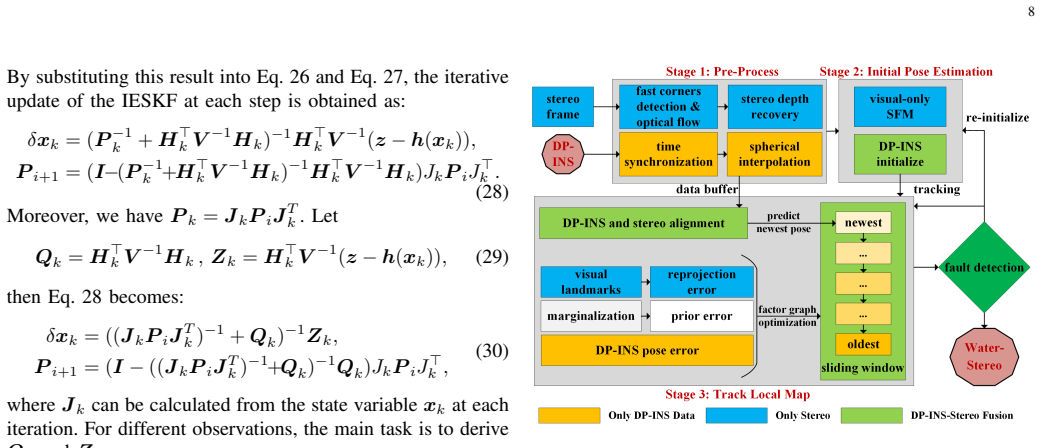
The carrying mechanism is the triple-subsystem front-end plus an asynchronous factor graph. UBSL, an underwater binocular structured-light module whose laser line is swept by an oscillating mirror at 2 Hz, produces 70 Hz scans that only become usable sweeps if each scan line is undistorted by the robot's motion; DP-INS supplies the 100 Hz poses that make this undistortion possible. Water-UBSL then tightly couples Sweep-NDT registration with DP-INS in an IESKF, Water-Stereo couples DP-INS with stereo feature optimization, and a multi-modal factor graph adds, interpolates, and removes nodes and edges as constraints arrive at different rates, gated by the fault-detection module.
What would settle it
Run the system in a scene where the DP-INS is deliberately biased (for example, by unmodeled DVL scale error or a strong water current) while the stereo and structured-light sensors are healthy, then check whether the fault-detection gates keep rejecting valid corrections; if valid constraints are rejected and the trajectory diverges, the central assumption fails.
Extended reading notes
Core claim
Water-DSLAM claims to be the first structured-light-based underwater multi-modal dense SLAM system that runs continuously through partial sensor faults. The central discovery is that a high-frequency ESKF-based DP-INS backbone, fusing IMU, DVL, and pressure data, can carry the system across dropouts of the external perception sensors, while tightly coupled UBSL and stereo subsystems supply relative constraints that correct drift, and a multi-modal factor graph back-end with statistical fault detection selectively accepts those constraints. In experiments, the system reports 0.039 m trajectory RMSE with 100 percent continuity during partial sensor dropout, and point-cloud densities around 6922.4 points per cubic meter over a 750 cubic meter sinkhole volume, roughly ten times denser than the compared fixed-line structured-light and multi-modal baselines.
Load-bearing premise
The whole fault-tolerance scheme trusts the DP-INS backbone as the reference for accepting or rejecting the other sensors' corrections, so if DP-INS itself drifts or its noise model is wrong, the system has no independent check.
Editorial extensions
If this is right
- If the claims hold, underwater robots can keep estimating pose and building dense maps through partial sensor failures because the DP-INS backbone continues when DVL, pressure, stereo, or structured-light measurements drop out.
- Dense structured-light mapping at roughly 7000 points per cubic meter makes fine-scale observation possible in darkness and texture-sparse water, such as inspecting cave walls, boulders, and river structures.
- The fault-detection and asynchronous graph maintenance strategy provides a template for fusing intermittent heterogeneous sensors on other underwater vehicles with different sensor suites.
- The reported 100 percent continuity under partial dropout, if robust, removes the need for frequent reinitialization, a known failure mode in underwater visual-inertial odometry.
Reading between the lines
- Inference: because the fault-detection gates treat DP-INS as the trusted reference, a natural extension is reciprocal validation, where loop closures or UBSL constraints are used to detect DP-INS drift and trigger re-calibration; the paper does not claim this.
- Inference: the point-density metric (points per cubic meter) may not be directly comparable across methods unless the surveyed volume and overlap are identical; future comparisons could standardize density over the same surveyed region.
- Inference: the same fusion pattern of active structured light with inertial and acoustic sensing could plausibly transfer to low-visibility non-underwater settings such as dusty or smoke-filled environments, though the paper does not make that claim.
Signed reviews
Editorial analysis
A structured set of objections, weighed in public.
Referee Report
Summary. The paper presents Water-DSLAM, a multi-modal dense SLAM system for underwater robots, together with a custom sensor platform (Water-Scanner) that includes an IMU, DVL, pressure sensor, stereo camera, and a self-designed scanning underwater binocular structured-light (UBSL) module. The front-end consists of three subsystems: DP-INS (an ESKF fusing IMU, DVL, and pressure data), Water-UBSL (IESKF-based tight coupling of UBSL sweeps with DP-INS), and Water-Stereo (DP-INS-aided stereo visual odometry). The back-end is a factor graph that accepts or rejects subsystem constraints through fault-detection thresholds and maintains asynchronous, intermittently available factors. Experiments in a pool, a dark underwater scene, a 16-meter-deep sinkhole, and a field river report trajectory RMSE of 0.039 m at 100% continuity under partial sensor dropout and dense mapping at 6922.4 points/m^3 in a 750 m^3 volume.
Significance. If the reported results hold, this would be a valuable and rare integrated system: it combines a custom structured-light scanner with inertial-acoustic-visual fusion in a fault-tolerant architecture, and it is evaluated in real underwater environments rather than simulation. The pool experiments use an independent Apriltag-based ground truth, the derivations in Sections V and VI are largely standard and internally consistent, and the hardware and data collection are substantial. The main contributions—tight UBSL/DP-INS coupling, factor-graph maintenance under asynchronous sensor faults, and high-density structured-light mapping in dark underwater scenes—are potentially significant for underwater in-situ observation. However, the central fault-tolerance claim and the quantitative superiority claims are not yet fully supported by the evidence presented.
major comments (4)
- [VI.A (Eqs. 43-49), V.A.6, III.B] The fault-detection mechanism treats DP-INS as the trusted reference: UBSL and Stereo constraints are accepted or rejected according to their discrepancy from DP-INS relative poses, with thresholds τt=2.0σ_INS and τR=4.0σ_INS. But DP-INS is not an independent truth source; it fuses DVL and PS, which Section III.B explicitly identifies as external sensors subject to temporary faults. The sliding-window statistical test in V.A.6 can reject large outliers but cannot detect a slowly growing bias in DVL or PS (e.g., from acoustic multipath or pressure drift), because such a bias is consistent within the window. In that regime, valid UBSL and Stereo constraints would be discarded as inconsistent with the biased DP-INS, and the factor graph is initialized and anchored to the same biased reference. None of the experiments inject DVL or PS bias or dropout inside DP-INS; they only test dropout of UBSL and Stereo while DP-INS remains healthy. Thus the central 'uninterrupted, fault-tolerant' claim is not established for the case where the trusted reference itself drifts.
- [Tables II-VI; VII.A] Every quantitative result appears to come from a single run per condition. The tables report no standard deviations, no repeated trials, and no statistical comparison, although the pool environments and the free-motion trajectories are likely subject to considerable run-to-run variability. In addition, the baselines were not the original implementations but 'only reproduce core ideas on our platform' (VII.A), which makes the comparisons less definitive. For instance, the headline improvement of 0.039 m over 0.068 m ATE RMSE in Table VI, or the 100% versus ~25% continuity ratios, could be within run-to-run variation or implementation differences. To support the claimed superiority, the authors should provide multiple runs per method with mean and standard deviation (or per-run values), and state exactly which parts of the baseline pipelines were reproduced.
- [VII.F, VII.G, Abstract] The '10 times denser than existing methods' claim is based on comparing point densities such as 6922.4 points/m^3 versus 664.2 points/m^3, but point density is not a method-invariant quantity. It depends on the scanning pattern, robot speed, standoff distance, sensor field of view, trajectory, and the volume over which the density is computed. The compared baselines use fixed-line structured light and different trajectories, so a density ratio does not by itself demonstrate a superiority of the mapping algorithm. The authors should either define a controlled density metric (e.g., same trajectory, same scanned volume, same distance range) or present additional metrics such as completeness, map consistency, and error versus an independent scan of the scene.
- [V.A.6, VI.A (Eqs. 43-49)] The fault-detection pipeline has several free thresholds—ξ, τt=2.0σ_INS, τR=4.0σ_INS, qthresh, Nthresh, ε—but no sensitivity analysis is provided. Since the entire fault-tolerance and 'uninterrupted operation' claim hinges on these thresholds, the authors should show how the system behaves when they are varied over reasonable ranges, and ideally justify σ_INS calibration. In Eq. (44), Nmatched and the eigenvalues λ3/λ1 are used to flag structural degeneracy, but Nmatched is never defined and the eigenvalue source (which point cloud, what neighborhood) is not specified; without these definitions the structural-fault criterion is not reproducible.
minor comments (6)
- [VI.C.8, Eq. (58)] The MAP estimation in Eq. (58) writes min_X while summing over xi∈Y and defining residuals in terms of Y; the optimization variable should be Y, not X.
- [VI.B, Eqs. (52), (55), (56)] There are repeated typos: 'ndoe' should be 'node'. Also the UBSL and Stereo factor definitions refer to 'the current node yj and the previous node yj'; it appears one of these should be yi.
- [VI.B, Eqs. (55), (56)] The frame notation is inconsistent: the residuals use T^W_yj and T^W_yi but the preceding text defines poses as T^I_yi; the frames should be aligned or explicitly defined.
- [VII.D.2] In the mapping evaluation paragraph, the text mentions 'USBL constraints' (line beginning 'Water-Scanner, based on a scanning structured light system') but the system is consistently called UBSL elsewhere; this should be corrected.
- [Table V] The table uses ∞* for interrupted runs and color coding, but the meaning of ∞ is not explained in the caption or text; the reader cannot tell whether this is a divergent estimate, a failed optimization, or missing data.
- [Abstract and I.B] The claims 'first complete solution' and 'first structured-light-based underwater multi-modal dense SLAM system' are strong and difficult to verify; the authors should soften or qualify them relative to the specific sensor configuration and public evidence.
Circularity Check
Fault-detection gate uses DP-INS as the reference for constraints that were themselves estimated with DP-INS as an input; final trajectory RMSE is still externally anchored.
-
self definitional
[Sec. VI.A.1, Eqs. (43)-(45); Sec. V.B.1, Eq. (32)]
"First, the discrepancy between point cloud matching and DP-INS estimates is quantified ... ∆t =∥tUBSL− tINS∥2, ∆R =∥ logSO(3)(R⊤UBSLRINS)∨∥2 ... A constraint is flagged as faulty if any of the following conditions are met: F = (1, if (∆t>τ t)∨ (∆R>τ R)∨ (S = 1), 0 otherwise) ... z−h(xk) = [pDP−INS−pk, logSO(3)(R⊤kRDP−INS)∨]⊤."
The t_UBSL/R_UBSL being checked are not raw UBSL registrations; they are outputs of the Water-UBSL IESKF, whose observation model includes the DP-INS pose as a measurement (Eq. 32). The 'inconsistency' measured in Eq. 43 is therefore the deviation of an estimate that already contains DP-INS from DP-INS itself. A bad UBSL match is pulled toward DP-INS by the filter and can pass the gate, while a biased DP-INS (e.g., from undetected DVL/PS faults) makes good UBSL matches look faulty and discards the corrections needed to fix the bias. The same pattern appears in Sec. VI.A.2 for stereo: the Water-Stereo sliding-window optimization contains the DP-INS factor (Eq. 41) and is then gated against DP-INS (Eqs. 46-49). This is a self-referential validation loop rather than an independent check.
full rationale
Most of the paper's quantitative claims are anchored externally: pool trajectories are evaluated against an Apriltag marker detected by a global camera, DVL and PS are physical sensors providing absolute measurements, and the reported mapping densities are direct point-cloud statistics. The IESKF and factor-graph equations are standard multi-sensor fusion formulations, and the comparisons to VINS-Fusion, DIP-Fusion, Visual-DVL Fusion, and structured-light baselines are against external methods. The one genuinely self-referential element is the fault-detection design: DP-INS is both an input to Water-UBSL and Water-Stereo and the reference against which those subsystems' constraints are accepted or rejected, so the 'fault-tolerant' validation does not cover the case where the trusted reference itself drifts. This is a real but limited self-reference; it does not reduce the headline trajectory RMSE or density numbers to the paper's own outputs. Score 2 reflects one minor load-bearing self-reference, not a fully circular derivation chain.
Assumptions & free parameters
free parameters (7)
- Fault-detection outlier threshold ξ (DP-INS) =
3 (default; no reported value used in experiments)
- UBSL fault-detection thresholds τ_t=2.0σ_INS, τ_R=4.0σ_INS =
multipliers 2.0 and 4.0
- UBSL structural-degeneracy thresholds N_thresh and ε =
not reported
- Water-Stereo fault thresholds q_thresh, τ_t, τ_R =
not reported
- NDT voxel size and Gauss-Newton convergence parameters =
not reported
- Factor graph node rate (5 Hz) =
5 Hz
- DP-INS ESKF noise covariances Q and V =
not reported
assumptions (6)
- standard math IESKF update equations are valid as derived in FAST-LIO [48]; the paper applies them without re-deriving convergence or observability.
- domain assumption The IMU provides continuous, valid data; only external sensors fail.
- domain assumption The DVL velocity observation model v_dvl = R_D^I v is unbiased when the DVL has bottom lock.
- domain assumption The UBSL refraction-based measurement model from [46] is accurate under field conditions; the paper does not re-validate it.
- domain assumption The environment is static and rigid during mapping.
- domain assumption The magnetometer provides absolute orientation underwater despite magnetic disturbances.
Cite this review
Pith. "Pith review of An Underwater, Fault-Tolerant, Laser-Aided Robotic Multi-Modal Dense SLAM System for Continuous Underwater In-Situ Observation." pith.science (2026). https://pith.science/paper/IHXPPKCK
@misc{pith2026250421826,
  author       = {Pith},
  title        = {Pith review of: An Underwater, Fault-Tolerant, Laser-Aided Robotic Multi-Modal Dense SLAM System for Continuous Underwater In-Situ Observation},
  year         = {2026},
  howpublished = {\url{https://pith.science/paper/IHXPPKCK}},
  note         = {Machine review of arXiv:2504.21826}
}
read the original abstract
Existing underwater SLAM systems are difficult to work effectively in texture-sparse and geometrically degraded underwater environments, resulting in intermittent tracking and sparse mapping. Therefore, we present Water-DSLAM, a novel laser-aided multi-sensor fusion system that can achieve uninterrupted, fault-tolerant dense SLAM capable of continuous in-situ observation in diverse complex underwater scenarios through three key innovations: Firstly, we develop Water-Scanner, a multi-sensor fusion robotic platform featuring a self-designed Underwater Binocular Structured Light (UBSL) module that enables high-precision 3D perception. Secondly, we propose a fault-tolerant triple-subsystem architecture combining: 1) DP-INS (DVL- and Pressure-aided Inertial Navigation System): fusing inertial measurement unit, doppler velocity log, and pressure sensor based Error-State Kalman Filter (ESKF) to provide high-frequency absolute odometry 2) Water-UBSL: a novel Iterated ESKF (IESKF)-based tight coupling between UBSL and DP-INS to mitigate UBSL's degeneration issues 3) Water-Stereo: a fusion of DP-INS and stereo camera for accurate initialization and tracking. Thirdly, we introduce a multi-modal factor graph back-end that dynamically fuses heterogeneous sensor data. The proposed multi-sensor factor graph maintenance strategy efficiently addresses issues caused by asynchronous sensor frequencies and partial data loss. Experimental results demonstrate Water-DSLAM achieves superior robustness (0.039 m trajectory RMSE and 100\% continuity ratio during partial sensor dropout) and dense mapping (6922.4 points/m^3 in 750 m^3 water volume, approximately 10 times denser than existing methods) in various challenging environments, including pools, dark underwater scenes, 16-meter-deep sinkholes, and field rivers. Our project is available at https://water-scanner.github.io/.
Figures


Figures from the paper (15 more)



Reference graph
Works this paper leans on
-
[1]
Design and validation of a robotic control law for observation of deep-ocean jellyfish,
J. H. Rife and S. M. Rock, “Design and validation of a robotic control law for observation of deep-ocean jellyfish,” IEEE Transactions on Robotics, vol. 22, no. 2, pp. 282–291, 2006
work page 2006
-
[2]
Mobile robotic platforms for the acoustic tracking of deep-sea demersal fishery re- sources,
I. Masmitja, J. Navarro, S. Gom ´ariz, J. Aguzzi, B. Kieft, T. O’Reilly, K. Katija, P.-J. Bouvet, C. Fannjiang, M. Vigo et al. , “Mobile robotic platforms for the acoustic tracking of deep-sea demersal fishery re- sources,” Science Robotics, vol. 5, no. 48, p. eabc3701, 2020
work page 2020
-
[3]
An in situ digital synthesis strategy for the discovery and description of ocean life,
J. A. Burns, K. P. Becker, D. Casagrande, J. Daniels, P. Roberts, E. Orenstein, D. M. V ogt, Z. E. Teoh, R. Wood, A. H. Yin et al., “An in situ digital synthesis strategy for the discovery and description of ocean life,” Science Advances, vol. 10, no. 3, p. eadj4960, 2024
work page 2024
-
[4]
Development of bioinspired multimodal underwater robot “hero-blue
T. Kim, J. Kim, and S.-C. Yu, “Development of bioinspired multimodal underwater robot “hero-blue” for walking, swimming, and crawling,” IEEE Transactions on Robotics , vol. 40, pp. 1421–1438, 2024
work page 2024
-
[5]
Multi-environment robotic transitions through adaptive morphogenesis,
R. Baines, S. K. Patiballa, J. Booth, L. Ramirez, T. Sipple, A. Garcia, F. Fish, and R. Kramer-Bottiglio, “Multi-environment robotic transitions through adaptive morphogenesis,” Nature, vol. 610, no. 7931, pp. 283– 289, 2022
work page 2022
-
[6]
Real-time visual slam for autonomous underwater hull inspection using visual saliency,
A. Kim and R. M. Eustice, “Real-time visual slam for autonomous underwater hull inspection using visual saliency,” IEEE Transactions on Robotics, vol. 29, no. 3, pp. 719–733, 2013
work page 2013
-
[7]
Past, present, and future of simultaneous localization and mapping: Toward the robust-perception age,
C. Cadena, L. Carlone, H. Carrillo, Y . Latif, D. Scaramuzza, J. Neira, I. Reid, and J. J. Leonard, “Past, present, and future of simultaneous localization and mapping: Toward the robust-perception age,” IEEE Transactions on robotics, vol. 32, no. 6, pp. 1309–1332, 2016
2016
-
[8]
A fast in-motion alignment method for ins/dvl in rough sea conditions,
H. Qin, X. Wang, G. Wang, M. Hu, Y . Bian, X. Qin, and R. Ding, “A fast in-motion alignment method for ins/dvl in rough sea conditions,” IEEE Transactions on Instrumentation and Measurement , 2024
work page 2024
Show all 53 references
-
[9]
Dual-slam: A framework for robust single camera navigation,
H. Huang, W.-Y . Lin, S. Liu, D. Zhang, and S.-K. Yeung, “Dual-slam: A framework for robust single camera navigation,” in 2020 IEEE/RSJ International Conference on Intelligent Robots and Systems (IROS) . IEEE, 2020, pp. 4942–4949
2020
-
[10]
Underwater pose slam using gmm scan matching for a mechanical profiling sonar,
P. Vial, N. Palomeras, J. Sol `a, and M. Carreras, “Underwater pose slam using gmm scan matching for a mechanical profiling sonar,” Journal of Field Robotics, vol. 41, no. 3, pp. 511–538, 2024. 20
2024
-
[11]
Development, calibration, and image processing of underwater structured light vision system: A survey,
J. Fan, X. Wang, C. Zhou, Y . Ou, F. Jing, and Z. Hou, “Development, calibration, and image processing of underwater structured light vision system: A survey,” IEEE Transactions on Instrumentation and Measure- ment, vol. 72, pp. 1–18, 2023
2023
-
[12]
Three birds, one stone: Unified laser- based 3-d reconstruction across different media,
C. Gu, Y . Cong, and G. Sun, “Three birds, one stone: Unified laser- based 3-d reconstruction across different media,” IEEE Transactions on Instrumentation and Measurement , vol. 70, pp. 1–12, 2020
2020
-
[13]
Svin2: A multi-sensor fusion-based underwater slam system,
S. Rahman, A. Quattrini Li, and I. Rekleitis, “Svin2: A multi-sensor fusion-based underwater slam system,” The International Journal of Robotics Research, vol. 41, no. 11-12, pp. 1022–1042, 2022
2022
-
[14]
A fully-automatic side-scan sonar simultaneous localization and mapping framework,
J. Zhang, Y . Xie, L. Ling, and J. Folkesson, “A fully-automatic side-scan sonar simultaneous localization and mapping framework,” IET Radar, Sonar & Navigation , vol. 18, no. 5, pp. 674–683, 2024
2024
-
[15]
Experi- mental comparison of open source visual-inertial-based state estimation algorithms in the underwater domain,
B. Joshi, S. Rahman, M. Kalaitzakis, B. Cain, J. Johnson, M. Xanthidis, N. Karapetyan, A. Hernandez, A. Q. Li, N. Vitzilaios et al. , “Experi- mental comparison of open source visual-inertial-based state estimation algorithms in the underwater domain,” in 2019 IEEE/RSJ Interna...
2019
-
[16]
Vins-mono: A robust and versatile monocular visual-inertial state estimator,
T. Qin, P. Li, and S. Shen, “Vins-mono: A robust and versatile monocular visual-inertial state estimator,” IEEE transactions on robotics , vol. 34, no. 4, pp. 1004–1020, 2018
2018
-
[17]
Detecting loop closure using enhanced image for underwater vins-mono,
H. Zhao, R. Zheng, M. Liu, and S. Zhang, “Detecting loop closure using enhanced image for underwater vins-mono,” in Global Oceans 2020: Singapore–US Gulf Coast . IEEE, 2020, pp. 1–6
2020
-
[18]
An open-source, fiducial-based, underwater stereo visual-inertial localization method with refraction correction,
P. Zhang, Z. Wu, J. Wang, S. Kong, M. Tan, and J. Yu, “An open-source, fiducial-based, underwater stereo visual-inertial localization method with refraction correction,” in 2021 IEEE/RSJ International Conference on Intelligent Robots and Systems (IROS) . IEEE, 2021, pp. 4331–4336
2021
-
[19]
Sm/vio: Robust underwater state estimation switching between model-based and visual inertial odometry,
B. Joshi, H. Damron, S. Rahman, and I. Rekleitis, “Sm/vio: Robust underwater state estimation switching between model-based and visual inertial odometry,” in 2023 IEEE International Conference on Robotics and Automation (ICRA) . IEEE, 2023, pp. 5192–5199
2023
-
[20]
Hybrid visual inertial odometry for robust underwater estimation,
B. Joshi, C. Bandara, I. Poulakakis, H. G. Tanner, and I. Rekleitis, “Hybrid visual inertial odometry for robust underwater estimation,” in OCEANS 2023-MTS/IEEE US Gulf Coast . IEEE, 2023, pp. 1–7
2023
-
[21]
Acoustic-vins: Tightly coupled acoustic- visual-inertial navigation system for autonomous underwater vehicles,
J. Song, W. Li, and X. Zhu, “Acoustic-vins: Tightly coupled acoustic- visual-inertial navigation system for autonomous underwater vehicles,” IEEE Robotics and Automation Letters , 2023
2023
-
[22]
Robust underwater visual slam fusing acoustic sensing,
E. Vargas, R. Scona, J. S. Willners, T. Luczynski, Y . Cao, S. Wang, and Y . R. Petillot, “Robust underwater visual slam fusing acoustic sensing,” in 2021 IEEE International Conference on Robotics and Automation (ICRA). IEEE, 2021, pp. 2140–2146
2021
-
[23]
Tightly- coupled visual-dvl fusion for accurate localization of underwater robots,
Y . Huang, P. Li, S. Yan, Y . Ou, Z. Wu, M. Tan, and J. Yu, “Tightly- coupled visual-dvl fusion for accurate localization of underwater robots,” in 2023 IEEE/RSJ International Conference on Intelligent Robots and Systems (IROS). IEEE, 2023, pp. 8090–8095
2023
-
[24]
Visual- inertial-acoustic sensor fusion for accurate autonomous localization of underwater vehicles,
Y . Huang, P. Li, S. Ma, S. Yan, M. Tan, J. Yu, and Z. Wu, “Visual- inertial-acoustic sensor fusion for accurate autonomous localization of underwater vehicles,” IEEE Transactions on Cybernetics , 2024
2024
-
[25]
Aqua-slam: Tightly-coupled underwater acoustic-visual-inertial slam with sensor calibration,
S. Xu, K. Zhang, and S. Wang, “Aqua-slam: Tightly-coupled underwater acoustic-visual-inertial slam with sensor calibration,” IEEE Transactions on Robotics, 2025
2025
-
[26]
An integrated visual odometry system for underwater vehicles,
Z. Xu, M. Haroutunian, A. J. Murphy, J. Neasham, and R. Norman, “An integrated visual odometry system for underwater vehicles,” IEEE Journal of Oceanic Engineering , vol. 46, no. 3, pp. 848–863, 2020
2020
-
[27]
Sonar visual inertial slam of underwater structures,
S. Rahman, A. Q. Li, and I. Rekleitis, “Sonar visual inertial slam of underwater structures,” in 2018 IEEE International Conference on Robotics and Automation (ICRA) . IEEE, 2018, pp. 5190–5196
2018
-
[28]
Svin2: An underwater slam system using sonar, visual, inertial, and depth sensor,
——, “Svin2: An underwater slam system using sonar, visual, inertial, and depth sensor,” in 2019 IEEE/RSJ International Conference on Intelligent Robots and Systems (IROS) . IEEE, 2019, pp. 1861–1868
2019
-
[29]
Absolute scale estimation for underwater monocular visual odometry based on 2-d imaging sonar,
D. Yang, H. Ai, J. Liu, and B. He, “Absolute scale estimation for underwater monocular visual odometry based on 2-d imaging sonar,” Measurement, vol. 190, p. 110665, 2022
2022
-
[30]
Camera-sonar combination for im- proved underwater localization and mapping,
A. Cardaillac and M. Ludvigsen, “Camera-sonar combination for im- proved underwater localization and mapping,” IEEE Access, 2023
2023
-
[31]
An open-source bio-inspired solution to underwater slam,
L. Silveira, F. Guth, P. Drews-Jr, P. Ballester, M. Machado, F. Codevilla, N. Duarte-Filho, and S. Botelho, “An open-source bio-inspired solution to underwater slam,” IFAC-PapersOnLine, vol. 48, no. 2, pp. 212–217, 2015
2015
-
[32]
Underwater caves sonar data set,
A. Mallios, E. Vidal, R. Campos, and M. Carreras, “Underwater caves sonar data set,” The International Journal of Robotics Research, vol. 36, no. 12, pp. 1247–1251, 2017
2017
-
[33]
Real-time underwater 3d reconstruction using global context and active labeling,
R. DeBortoli, A. Nicolai, F. Li, and G. A. Hollinger, “Real-time underwater 3d reconstruction using global context and active labeling,” in 2018 IEEE International Conference on Robotics and Automation (ICRA). IEEE, 2018, pp. 6204–6211
2018
-
[34]
Wide aperture imaging sonar reconstruction using generative models,
E. Westman and M. Kaess, “Wide aperture imaging sonar reconstruction using generative models,” in 2019 IEEE/RSJ International Conference on Intelligent Robots and Systems (IROS). IEEE, 2019, pp. 8067–8074
2019
-
[35]
Autonomous 3-d mapping and safe-path planning for underwater terrain reconstruction using multi- level coverage trees,
Z. Shen, J. Song, K. Mittal, and S. Gupta, “Autonomous 3-d mapping and safe-path planning for underwater terrain reconstruction using multi- level coverage trees,” in OCEANS 2017-Anchorage. IEEE, 2017, pp. 1–6
2017
-
[36]
Ct-cpp: Coverage path planning for 3d terrain reconstruction using dynamic coverage trees,
——, “Ct-cpp: Coverage path planning for 3d terrain reconstruction using dynamic coverage trees,” IEEE Robotics and Automation Letters , vol. 7, no. 1, pp. 135–142, 2021
2021
-
[37]
Unified underwater structure-from-motion,
K. Ichimaru, Y . Taguchi, and H. Kawasaki, “Unified underwater structure-from-motion,” in 2019 International Conference on 3D Vision (3DV). IEEE, 2019, pp. 524–532
2019
-
[38]
Hy- perspectral 3d mapping of underwater environments,
M. Ferrera, A. Arnaubec, K. Isteni ˇc, N. Gracias, and T. Bajjouk, “Hy- perspectral 3d mapping of underwater environments,” in Proceedings of the IEEE/CVF International Conference on Computer Vision , 2021, pp. 3703–3712
2021
-
[39]
Robust underwater slam using autonomous relocalisation,
J. S. Willners, Y . Carreno, S. Xu, T. Łuczy ´nski, S. Katagiri, J. Roe, `E. Pairet, Y . Petillot, and S. Wang, “Robust underwater slam using autonomous relocalisation,” IFAC-PapersOnLine, vol. 54, no. 16, pp. 273–280, 2021
2021
-
[40]
High-resolution underwater robotic vision-based mapping and three-dimensional reconstruction for archae- ology,
M. Johnson-Roberson, M. Bryson, A. Friedman, O. Pizarro, G. Troni, P. Ozog, and J. C. Henderson, “High-resolution underwater robotic vision-based mapping and three-dimensional reconstruction for archae- ology,” Journal of Field Robotics , vol. 34, no. 4, pp. 625–643, 2017
2017
-
[41]
Application of structured light imaging for high resolution mapping of underwater archaeological sites,
C. Roman, G. Inglis, and J. Rutter, “Application of structured light imaging for high resolution mapping of underwater archaeological sites,” in OCEANS’10 IEEE SYDNEY . IEEE, 2010, pp. 1–9
2010
-
[42]
Generation of high-resolution three-dimensional reconstructions of the seafloor in color using a single camera and structured light,
A. Bodenmann, B. Thornton, and T. Ura, “Generation of high-resolution three-dimensional reconstructions of the seafloor in color using a single camera and structured light,” Journal of Field Robotics , vol. 34, no. 5, pp. 833–851, 2017
2017
-
[43]
Underwater 3d scanning system for cultural heritage documentation,
C. Br ¨auer-Burchardt, C. Munkelt, M. Bleier, M. Heinze, I. Gebhart, P. K ¨uhmstedt, and G. Notni, “Underwater 3d scanning system for cultural heritage documentation,” Remote Sensing , vol. 15, no. 7, p. 1864, 2023
2023
-
[44]
Improving self-consistency in underwa- ter mapping through laser-based loop closure,
T. Hitchcox and J. R. Forbes, “Improving self-consistency in underwa- ter mapping through laser-based loop closure,” IEEE Transactions on Robotics, vol. 39, no. 3, pp. 1873–1892, 2023
2023
-
[45]
Inspection of an underwater structure using point-cloud slam with an auv and a laser scanner,
A. Palomer, P. Ridao, and D. Ribas, “Inspection of an underwater structure using point-cloud slam with an auv and a laser scanner,” Journal of field robotics , vol. 36, no. 8, pp. 1333–1344, 2019
2019
-
[46]
Binocular structured light 3-d reconstruction system for low-light underwater environments: Design, modeling, and laser-based calibration,
Y . Ou, J. Fan, C. Zhou, S. Tian, L. Cheng, and M. Tan, “Binocular structured light 3-d reconstruction system for low-light underwater environments: Design, modeling, and laser-based calibration,” IEEE Transactions on Instrumentation and Measurement , vol. 72, pp. 1–14, 2023
2023
-
[47]
Water-mbsl: Un- derwater movable binocular structured light-based high-precision dense reconstruction framework,
Y . Ou, J. Fan, C. Zhou, L. Cheng, and M. Tan, “Water-mbsl: Un- derwater movable binocular structured light-based high-precision dense reconstruction framework,”IEEE Transactions on Industrial Informatics, vol. 20, no. 4, pp. 6142–6154, 2023
2023
-
[48]
Fast-lio: A fast, robust lidar-inertial odometry package by tightly-coupled iterated kalman filter,
W. Xu and F. Zhang, “Fast-lio: A fast, robust lidar-inertial odometry package by tightly-coupled iterated kalman filter,” IEEE Robotics and Automation Letters, vol. 6, no. 2, pp. 3317–3324, 2021
2021
-
[49]
A general optimization-based framework for global pose estimation with multiple sensors,
T. Qin, S. Cao, J. Pan, and S. Shen, “A general optimization-based framework for global pose estimation with multiple sensors,” arXiv preprint arXiv:1901.03642, 2019
1901 arXiv
-
[50]
Hybrid-vins: Underwater tightly coupled hybrid visual inertial dense slam for auv,
Y . Ou, J. Fan, C. Zhou, P. Zhang, and Z.-G. Hou, “Hybrid-vins: Underwater tightly coupled hybrid visual inertial dense slam for auv,” IEEE Transactions on Industrial Electronics , 2024
2024
-
[51]
Evo: A geometric approach to event-based 6-dof parallel tracking and mapping in real time,
H. Rebecq, T. Horstsch ¨afer, G. Gallego, and D. Scaramuzza, “Evo: A geometric approach to event-based 6-dof parallel tracking and mapping in real time,” IEEE Robotics and Automation Letters , vol. 2, no. 2, pp. 593–600, 2016
2016
-
[52]
Structured light-based underwater collision-free navigation and dense mapping system for refined exploration in unknown dark environments,
Y . Ou, J. Fan, C. Zhou, S. Kang, Z. Zhang, Z.-G. Hou, and M. Tan, “Structured light-based underwater collision-free navigation and dense mapping system for refined exploration in unknown dark environments,” IEEE Transactions on Systems, Man, and Cybernetics: Systems , 2024
2024
-
[53]
Extrinsic visual– inertial calibration for motion distortion correction of underwater 3d scans,
M. Castill ´on, R. Pi, N. Palomeras, and P. Ridao, “Extrinsic visual– inertial calibration for motion distortion correction of underwater 3d scans,” IEEE Access, vol. 9, pp. 93 384–93 398, 2021
2021
Reviewed August 16, 2026 · model on record in the stance chip above.
Discussion (0). Continue with ORCID to comment.