REVIEW 5 major objections 6 minor 35 references
LF-GNSS: Towards More Robust Satellite Positioning with a Hard Example Mining Enhanced Learning-Filtering Deep Fusion Framework
T0 review · 5 major / 6 minor · reviewed 2026-08-07 · deepseek-v4-flash
Pith's one-line read A learning-filtering deep fusion framework claims more accurate urban GNSS positioning by letting a neural network set the Kalman filter's noise and innovation corrections from per-satellite signal features.
desk verdict A plausible learning-plus-EKF GNSS fusion with two genuinely new twists, but the hard-example loss as written zeros out the hardest samples and the evaluation lacks error bars and cross-dataset validation. read the letter →
The pith
A machine-rendered reading of the paper's core claim, the machinery that carries it, and where it could break.
The reading
What carries the argument
The load-bearing mechanism is the learned EKF update. For each epoch, a network with multi-head self-attention and fully connected layers (dimensions 64, 128, 64) consumes per-satellite features — signal-to-noise ratio, elevation, azimuth, pseudorange residual, and a new DOP-contribution feature — and produces (1) the diagonal observation-noise covariance matrix $R$, kept positive via Softplus, and (2) the innovation compensation vector $v_c$. The EKF uses $R$ inside the innovation covariance and updates the state with $v_k + v_c$, using the Joseph-stabilized covariance update. The DOP-contribution feature is computed by removing each satellite from the design matrix and recomputing DOP, so the network sees each satellite's geometric importance. The dynamic hard-example-mining loss reweights training epochs by Euclidean ENU error, focusing learning on hard positioning cases.
What would settle it
Re-run the private route comparison with ground truth from survey-grade total-station marks or a post-processed open-sky RTK/INS solution, and check whether LF-GNSS's 3D RMSE margins over TDL-GNSS and RTKLIB (1.91 m versus 2.70 m on ALGO-B, for example) survive; if the margin collapses to noise, the central accuracy claim is falsified.
Extended reading notes
Core claim
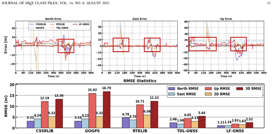
The central claim is that the tight fusion of learning and filtering works: a multi-head attention network that outputs a per-epoch diagonal measurement-noise matrix $R$ and a compensated innovation vector $v_c$, fed into a standard EKF, yields more accurate and stable pseudorange-only positioning than hand-tuned filters or earlier learning-based estimators. The paper reports 2D and 3D RMSE improvements of 79.55%–84.99% over CSSRLIB, goGPS, and RTKLIB, and a 53.68% improvement over TDL-GNSS on the private route, with the full framework reaching 3D RMSE of 1.91 m on ALGO-B while IE-PPP reaches 2.55 m. Ablations show that both the DOP-contribution feature and the dynamic hard-example-mining loss contribute to the improvement.
Load-bearing premise
The evaluation treats the reference trajectories as exact ground truth — RTK/INS tightly coupled solutions on the private route and the provided references on the public datasets — so if those references carry meter-level errors in urban canyons, the reported RMSE differences between methods become unreliable.
Editorial extensions
If this is right
- The network adds only a small per-epoch forward pass, so LF-GNSS can run as a real-time pseudorange-only positioning engine on vehicles without IMU or camera.
- Because the learned outputs are noise covariances and innovation offsets rather than positions, the same model can handle changing satellite geometry and multiple constellations (GPS, BeiDou, Galileo, GLONASS) through the inter-system-bias state.
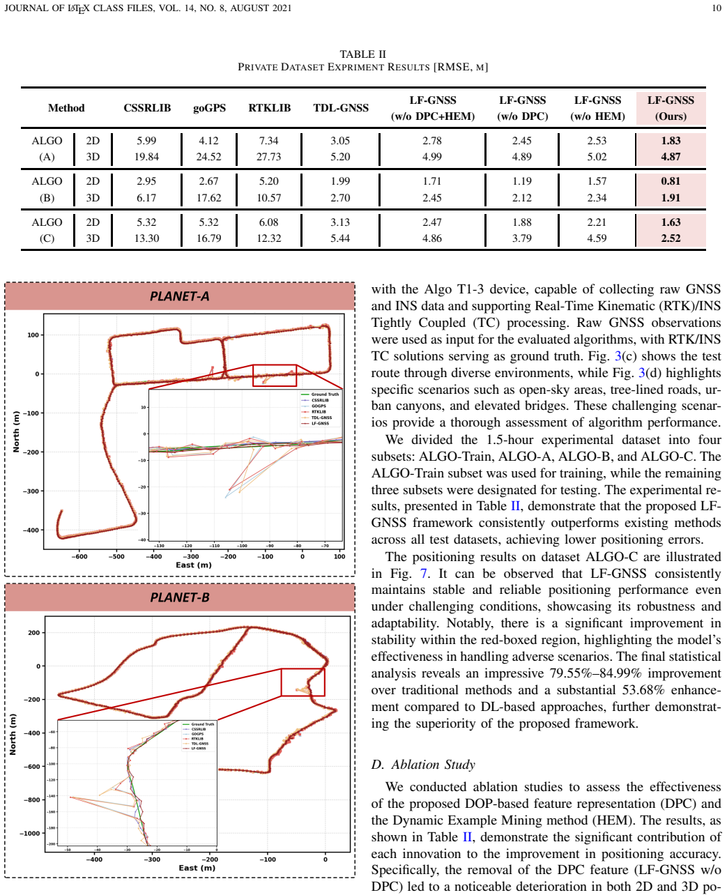
- On the private route, the full framework reaches 2D RMSE of 1.83 m on ALGO-A; removing the DOP feature raises it to 2.45 m and removing hard-example mining to 2.53 m, indicating both components carry part of the gain.
- Against carrier-phase PPP, LF-GNSS keeps 3D RMSE at 1.91 m on ALGO-B while IE-PPP gives 2.55 m, suggesting better stability in deep urban scenes.
- The planned open-source release of code and a collection of urban satellite-positioning datasets gives other groups the means to reproduce the comparisons.
Reading between the lines
- The framework's features are all derivable from pseudorange measurements and ephemeris, so the same learned $R$ and $v_c$ mechanism could plausibly be attached to other estimators, such as factor-graph optimization or an unscented Kalman filter, not just an EKF.
- The paper does not report cross-city generalization; a natural testable extension is to train on one city's urban dataset and evaluate on another, using the released code, to see whether the learned noise and innovation models transfer or overfit local canyon geometry.
- On open-sky segments, where all compared methods should agree, LF-GNSS should not be worse than the classical engines; a diagnostic that checks per-segment error would reveal whether the urban improvement comes with an open-sky cost.
Editorial analysis
A structured set of objections, weighed in public.
Referee Report
Summary. The manuscript proposes LF-GNSS, a deep-learning/Kalman-filter fusion framework for GNSS pseudorange positioning in urban environments. A multi-head-attention network takes per-satellite features (SNR, elevation, azimuth, pseudorange residual, and a new leave-one-out DOP contribution feature) and outputs a per-satellite measurement noise covariance R and an innovation compensation vector vc, which are injected into the EKF measurement update. Training uses a dynamic hard-example-mining loss on final ENU position error. The framework is evaluated against CSSRLIB, goGPS, RTKLIB, and TDL-GNSS on three public dataset families and a private vehicle dataset, with ablations of the DPC feature and the hard-example-mining loss on the private dataset only.
Significance. If the reported results hold, the framework would be a valuable sensor-free approach to urban GNSS positioning, with a simple and plausible integration of learned measurement noise and innovation compensation into a standard EKF, plus a novel per-satellite geometry feature. The open-source intent and the use of multiple public datasets are positive features. However, the current manuscript contains a mathematical inconsistency in the proposed hard-example-mining loss, and the evaluation has important gaps: single-run RMSEs without statistical tests, unquantified ground-truth reference quality, and ablations limited to the private dataset. These issues prevent the central claim of robust superiority from being accepted as stated.
major comments (5)
- [Section III-E, Eqs. (43)-(45)] The proposed hard-example-mining weight is inconsistent with its stated purpose. For the sample with Lbase = max(Lbase) in the batch, w = (1 - 1)^{γdynamic} = 0, so the hardest sample contributes zero to L_dhem. Moreover, for all samples w ∈ [0,1], and since γdynamic decreases as Lbase increases, w is actually larger for smaller Lbase; that is, easier samples receive the larger relative weights. Thus Eq. (45) implements a downweighting of large-error samples, not 'prioritizing challenging satellite signals.' The ablation in Table II therefore cannot be interpreted as evidence for hard-example mining as described. Please correct the formula (e.g., a focal-style factor that increases with error) or reframe the contribution as a robust loss, and re-run the ablation.
- [Section IV-C and IV-B] The evaluation treats the RTK/INS tightly coupled solutions (private dataset) and the provided reference trajectories (public datasets) as exact ground truth, but nowhere quantifies their accuracy over the tested segments. Because the loss (Eqs. 41-46), all RMSE values in Tables I and II, and the claimed improvement percentages in Section IV-C are computed against these references, any meter-level reference error would directly bias the comparisons. Please report reference-quality metrics (e.g., percentage of fixed RTK epochs, baseline lengths, or an independent cross-check) for at least the private dataset, and discuss how reference error affects the reported margins.
- [Section III-D, Eqs. (35)-(40)] The training procedure requires gradients of the final-position loss with respect to the network outputs R_k and vc_k through the EKF measurement update, including the inversion S_k^{-1} and the Joseph-form covariance update. The manuscript does not describe how this backpropagation is implemented, whether automatic differentiation is used, or how numerical stability is guaranteed for learned R_k. This is essential for reproducibility and for assessing gradient health; please add the implementation details and any stability measures.
- [Tables I and II, Section IV-D] All results are single-run RMSE point estimates with no standard deviations, confidence intervals, or significance tests, even though LF-GNSS training is stochastic. Furthermore, the ablations for DPC and HEM are reported only on the private dataset (Table II), so the contributions are not validated on the public datasets. Please provide multi-seed statistics and, if possible, ablations on at least one public split.
- [Section IV-A and Eqs. (31), (34), (43)-(45)] Several hyperparameters that determine the filter and loss behavior are not specified: the process noise covariance Q_k, the initial state covariance sigmas σ_p0, σ_v0, σ_cb0, σ_cd0, σ_ISB0, and the loss coefficients α, γ, λ. Without these values, the experiments cannot be reproduced and the sensitivity of the method to these settings cannot be assessed. Please report all hyperparameter values and, ideally, a sensitivity analysis.
minor comments (6)
- [Table II caption] The word 'EXPRIMENT' should be 'EXPERIMENT'.
- [Equation (24)] DPC is defined via a generic 'DOP'; please specify whether HDOP, VDOP, PDOP, or GDOP is used in the leave-one-out difference, since the values and their interpretation differ.
- [Section III-C1] The output layer is described as mapping to a '2-dimensional output' but Rdiag and vc are both of dimension N; this should read 'two output heads' or similar.
- [Section III-C2] The input dimension is stated as d=8, while Section III-B lists only five features; please clarify what the remaining three feature channels are.
- [Section IV-B] The mapping from 'KLT-[3, 1, 2] and Whampoa' to 'IPNL-Train, IPNL-A, IPNL-B, and IPNL-C' is ambiguous; an explicit one-to-one table would improve reproducibility.
- [Section IV-C] The sentence about 79.55%-84.99% and 53.68% improvements should state that these percentages correspond to the ALGO-C 3D RMSE values; as written, 'final statistical analysis' could be read as an aggregate over all private test sets.
Circularity Check
No circularity: LF-GNSS is a standard supervised learning pipeline trained on labeled splits and evaluated on held-out subsets; no prediction reduces to a fitted input or to a self-citation chain.
full rationale
I walked the claimed derivation chain: coarse least-squares positioning, feature packing (SNR, elevation, azimuth, pseudorange residual, and DOP contribution), an attention-based network producing R and vc, an EKF measurement update using those outputs, and a supervised loss against ground-truth positions. The network outputs are learned parameters, and the final position is computed by the EKF from the current pseudoranges; it is not equal to any training target or fitted parameter by construction. Test results are reported on explicitly designated hold-out subsets (IPNL-A/B/C, GREAT-A/B/C, PLANET-A/B/C, ALGO-A/B/C) that were not used for training, so the claimed accuracy improvements are empirical holdout evaluations rather than renamed training fits. The DPC feature (Eq. 24) is a leave-one-out DOP difference; it is an input feature, and the final position does not reduce to it by definition. The loss functions (Eqs. 41-46) and EKF update (Eq. 39) are standard supervised training and inference mechanics, not circular predictions. No load-bearing self-citations were found: the references to prior feature-selection work ([18], [31], [32]) and to the TDL-GNSS baseline are external and do not by themselves force the paper's conclusions. Potential concerns about ground-truth reference accuracy or statistical significance are evaluation-validity questions, not circularity of the derivation. Therefore no specific circular step can be exhibited, and the appropriate score is 0.
Assumptions & free parameters
free parameters (5)
- alpha
- gamma
- lambda
- Process noise covariance Q
- Initial covariance sigmas
assumptions (5)
- domain assumption Standard pseudorange observation model with Saastamoinen and Klobuchar corrections
- domain assumption Constant velocity motion model with zero-mean Gaussian process noise
- domain assumption Backpropagation through the EKF is numerically feasible
- domain assumption Ground-truth trajectories are accurate enough for training and evaluation
- ad hoc to paper DPC feature (leave-one-out DOP contribution) is a valid satellite quality indicator
Cite this review
Pith. "Pith review of LF-GNSS: Towards More Robust Satellite Positioning with a Hard Example Mining Enhanced Learning-Filtering Deep Fusion Framework." pith.science (2026). https://pith.science/paper/KOK7JLNN
@misc{pith2026250519560,
  author       = {Pith},
  title        = {Pith review of: LF-GNSS: Towards More Robust Satellite Positioning with a Hard Example Mining Enhanced Learning-Filtering Deep Fusion Framework},
  year         = {2026},
  howpublished = {\url{https://pith.science/paper/KOK7JLNN}},
  note         = {Machine review of arXiv:2505.19560}
}
read the original abstract
Global Navigation Satellite System (GNSS) is essential for autonomous driving systems, unmanned vehicles, and various location-based technologies, as it provides the precise geospatial information necessary for navigation and situational awareness. However, its performance is often degraded by Non-Line-Of-Sight (NLOS) and multipath effects, especially in urban environments. Recently, Artificial Intelligence (AI) has been driving innovation across numerous industries, introducing novel solutions to mitigate the challenges in satellite positioning. This paper presents a learning-filtering deep fusion framework for satellite positioning, termed LF-GNSS. The framework utilizes deep learning networks to intelligently analyze the signal characteristics of satellite observations, enabling the adaptive construction of observation noise covariance matrices and compensated innovation vectors for Kalman filter input. A dynamic hard example mining technique is incorporated to enhance model robustness by prioritizing challenging satellite signals during training. Additionally, we introduce a novel feature representation based on Dilution of Precision (DOP) contributions, which helps to more effectively characterize the signal quality of individual satellites and improve measurement weighting. LF-GNSS has been validated on both public and private datasets, demonstrating superior positioning accuracy compared to traditional methods and other learning-based solutions. To encourage further integration of AI and GNSS research, we will open-source the code at https://github.com/GarlanLou/LF-GNSS, and release a collection of satellite positioning datasets for urban scenarios at https://github.com/GarlanLou/LF-GNSS-Dataset.
Figures


Figures from the paper (5 more)



Reference graph
Works this paper leans on
-
[1]
Gnss/multi- sensor fusion using continuous-time factor graph optimization for robust localization,
H. Zhang, C.-C. Chen, H. Vallery, and T. D. Barfoot, “Gnss/multi- sensor fusion using continuous-time factor graph optimization for robust localization,” IEEE Transactions on Robotics , 2024
work page 2024
-
[2]
A portfolio approach to nlos and multipath mitigation in dense urban areas
P. D. Groves, Z. Jiang, M. Rudi, and P. Strode, “A portfolio approach to nlos and multipath mitigation in dense urban areas.” The Institute of Navigation, 2013
work page 2013
-
[3]
Enhanced land vehicular gnss/ins combined system by using multiple-antenna with common clock,
B. Li, L. He, T. Liu et al., “Enhanced land vehicular gnss/ins combined system by using multiple-antenna with common clock,” IEEE Transac- tions on V ehicular Technology, 2024
work page 2024
-
[4]
Z. Shen, X. Li, X. Wang, Z. Wu, X. Li, Y . Zhou, and S. Li, “A novel factor graph framework for tightly coupled gnss/ins integration with carrier-phase ambiguity resolution,” IEEE Transactions on Intelligent Transportation Systems, 2024
work page 2024
-
[5]
X. Geng, Y . Guo, K. Tang, and W. Wu, “A spoofing algorithm for ground unmanned platform equipped with gnss/ins integrated navigation system,” IEEE Transactions on Instrumentation and Measurement, 2024
work page 2024
-
[6]
A covert spoofing algorithm for sins/gnss tightly integrated navigation system,
X. Geng, Y . Guo, K. Tang, W. Wu, Y . Ren, and G. Duan, “A covert spoofing algorithm for sins/gnss tightly integrated navigation system,” IEEE Transactions on Automation Science and Engineering , 2024
work page 2024
-
[7]
R2-gvio: A robust, real-time gnss-visual-inertial state estimator in urban challenging environments,
J. Song, W. Li, C. Duan, and X. Zhu, “R2-gvio: A robust, real-time gnss-visual-inertial state estimator in urban challenging environments,” IEEE Internet of Things Journal , 2024. JOURNAL OF LATEX CLASS FILES, VOL. 14, NO. 8, AUGUST 2021 12
work page 2024
-
[8]
Ingvio: A consistent invariant filter for fast and high-accuracy gnss-visual-inertial odometry,
C. Liu, C. Jiang, and H. Wang, “Ingvio: A consistent invariant filter for fast and high-accuracy gnss-visual-inertial odometry,” IEEE Robotics and Automation Letters , vol. 8, no. 3, pp. 1850–1857, 2023
work page 2023
Show all 35 references
-
[9]
Ic-gvins: A robust, real- time, ins-centric gnss-visual-inertial navigation system,
X. Niu, H. Tang, T. Zhang, J. Fan, and J. Liu, “Ic-gvins: A robust, real- time, ins-centric gnss-visual-inertial navigation system,” IEEE Robotics and Automation Letters , vol. 8, no. 1, pp. 216–223, 2022
2022
-
[10]
Gvins: Tightly coupled gnss–visual–inertial fusion for smooth and consistent state estimation,
S. Cao, X. Lu, and S. Shen, “Gvins: Tightly coupled gnss–visual–inertial fusion for smooth and consistent state estimation,” IEEE Transactions on Robotics , vol. 38, no. 4, pp. 2004–2021, 2022
2004
-
[11]
P 3-vins: Tightly- coupled ppp/ins/visual slam based on optimization approach,
T. Li, L. Pei, Y . Xiang, W. Yu, and T.-K. Truong, “P 3-vins: Tightly- coupled ppp/ins/visual slam based on optimization approach,” IEEE Robotics and Automation Letters , vol. 7, no. 3, pp. 7021–7027, 2022
2022
-
[12]
Invariant-ekf-based gnss/ins/vision integration with high convergence and accuracy,
C. Xia, X. Li, S. Li, and Y . Zhou, “Invariant-ekf-based gnss/ins/vision integration with high convergence and accuracy,” IEEE/ASME Transac- tions on Mechatronics , 2024
2024
-
[13]
End-to-end autonomous driving: Challenges and frontiers,
L. Chen, P. Wu, K. Chitta, B. Jaeger, A. Geiger, and H. Li, “End-to-end autonomous driving: Challenges and frontiers,” IEEE Transactions on Pattern Analysis and Machine Intelligence , 2024
2024
-
[14]
Paving the way with machine learning for seamless indoor–outdoor positioning: A survey,
M. Mallik, A. K. Panja, and C. Chowdhury, “Paving the way with machine learning for seamless indoor–outdoor positioning: A survey,” Information Fusion , vol. 94, pp. 126–151, 2023
2023
-
[15]
Machine learning in gnss multipath/nlos mitigation: Review and benchmark,
P. Xu, G. Zhang, B. Yang, and L.-T. Hsu, “Machine learning in gnss multipath/nlos mitigation: Review and benchmark,”IEEE Aerospace and Electronic Systems Magazine , 2024
2024
-
[16]
Machine learning utilization in gnss—use cases, challenges and future applications,
A. Siemuri, H. Kuusniemi, M. S. Elmusrati, P. V ¨alisuo, and A. Shamsuz- zoha, “Machine learning utilization in gnss—use cases, challenges and future applications,” in 2021 International Conference on Localization and GNSS (ICL-GNSS) . IEEE, 2021, pp. 1–6
2021
-
[17]
Resilient pseudorange error prediction and correction for gnss positioning in urban areas,
R. Sun, L. Fu, Q. Cheng, K.-W. Chiang, and W. Chen, “Resilient pseudorange error prediction and correction for gnss positioning in urban areas,” IEEE Internet of Things Journal , vol. 10, no. 11, pp. 9979–9988, 2023
2023
-
[18]
A reliable nlos error identification method based on lightgbm driven by multiple features of gnss signals,
X. Zhang, X. Wang, W. Liu, X. Tao, Y . Gu, H. Jia, and C. Zhang, “A reliable nlos error identification method based on lightgbm driven by multiple features of gnss signals,” Satellite Navigation, vol. 5, no. 1, pp. 1–20, 2024
2024
-
[19]
Prediction on the urban gnss measurement uncertainty based on deep learning networks with long short-term memory,
G. Zhang, P. Xu, H. Xu, and L.-T. Hsu, “Prediction on the urban gnss measurement uncertainty based on deep learning networks with long short-term memory,” IEEE Sensors Journal , vol. 21, no. 18, pp. 20 563– 20 577, 2021
2021
-
[20]
Improving the prediction of gnss satellite visibility in urban canyons based on a graph transformer,
S. Zheng, K. Zeng, Z. Li, Q. Wang, K. Xie, M. Liu, and S. Xie, “Improving the prediction of gnss satellite visibility in urban canyons based on a graph transformer,” NA VIGATION: Journal of the Institute of Navigation , vol. 71, no. 4, 2024
2024
-
[21]
A framework for graphical gnss multipath and nlos mitigation,
P. Xu, G. Zhang, Y . Zhong, B. Yang, and L.-T. Hsu, “A framework for graphical gnss multipath and nlos mitigation,” IEEE Transactions on Intelligent Transportation Systems , 2024
2024
-
[22]
Continuous-time factor graph optimization for trajectory smoothness of gnss/ins navigation in temporarily gnss-denied environments,
H. Zhang, X. Xia, M. Nitsch, and D. Abel, “Continuous-time factor graph optimization for trajectory smoothness of gnss/ins navigation in temporarily gnss-denied environments,” IEEE Robotics and Automation Letters, vol. 7, no. 4, pp. 9115–9122, 2022
2022
-
[23]
pyrtklib: An open-source package for tightly coupled deep learning and gnss integration for positioning in urban canyons,
R. Hu, P. Xu, Y . Zhong, and W. Wen, “pyrtklib: An open-source package for tightly coupled deep learning and gnss integration for positioning in urban canyons,” arXiv preprint arXiv:2409.12996 , 2024
2024 arXiv
-
[24]
Learning gnss positioning corrections for smartphones using graph convolution neural networks,
A. Mohanty and G. Gao, “Learning gnss positioning corrections for smartphones using graph convolution neural networks,” NA VIGATION: Journal of the Institute of Navigation , vol. 70, no. 4, 2023
2023
-
[25]
Tightly coupled graph neural network and kalman filter for smartphone positioning,
——, “Tightly coupled graph neural network and kalman filter for smartphone positioning,” NA VIGATION: Journal of the Institute of Navigation, vol. 71, no. 4, 2024
2024
-
[26]
Learning-enhanced adaptive robust gnss navigation in challenging environments,
Y . Ding, P. Chauchat, G. Pages, and P. Asseman, “Learning-enhanced adaptive robust gnss navigation in challenging environments,” IEEE Robotics and Automation Letters , vol. 7, no. 4, pp. 9905–9912, 2022
2022
-
[27]
Kalmannet: Neural network aided kalman filtering for partially known dynamics,
G. Revach, N. Shlezinger, X. Ni, A. L. Escoriza, R. J. Van Sloun, and Y . C. Eldar, “Kalmannet: Neural network aided kalman filtering for partially known dynamics,” IEEE Transactions on Signal Processing , vol. 70, pp. 1532–1547, 2022
2022
-
[28]
Mgins: A lane-level local- ization system for challenging urban environments using magnetic field matching/gnss/ins fusion,
X. Niu, L. Ding, Y . Wang, and J. Kuang, “Mgins: A lane-level local- ization system for challenging urban environments using magnetic field matching/gnss/ins fusion,” IEEE Transactions on Intelligent Transporta- tion Systems , 2024
2024
-
[29]
Gps meteorology: Mapping zenith wet delays onto precipitable water,
M. Bevis, S. Businger, S. Chiswell, T. A. Herring, R. A. Anthes, C. Rocken, and R. H. Ware, “Gps meteorology: Mapping zenith wet delays onto precipitable water,” Journal of Applied Meteorology (1988- 2005), pp. 379–386, 1994
1988
-
[30]
Ionospheric time-delay algorithm for single-frequency gps users,
J. A. Klobuchar, “Ionospheric time-delay algorithm for single-frequency gps users,” IEEE Transactions on aerospace and electronic systems , no. 3, pp. 325–331, 1987
1987
-
[31]
Ins aided gnss pseudo-range error prediction using machine learning for urban vehicle navigation,
T. Zhang, L. Zhou, X. Feng, J. Shi, Q. Zhang, and X. Niu, “Ins aided gnss pseudo-range error prediction using machine learning for urban vehicle navigation,” IEEE Sensors Journal , 2024
2024
-
[32]
Learning-based nlos detection and uncertainty prediction of gnss observations with transformer-enhanced lstm network,
H. Zhang, Z. Wang, and H. Vallery, “Learning-based nlos detection and uncertainty prediction of gnss observations with transformer-enhanced lstm network,” in 2023 IEEE 26th International Conference on Intelli- gent Transportation Systems (ITSC) . IEEE, 2023, pp. 910–917
2023
-
[33]
Fisheye camera aided gnss nlos detection and learning-based pseudorange bias correction for intelligent vehicles in urban canyons,
R. Hu, W. Wen, and L.-T. Hsu, “Fisheye camera aided gnss nlos detection and learning-based pseudorange bias correction for intelligent vehicles in urban canyons,” in 2023 IEEE 26th International Conference on Intelligent Transportation Systems (ITSC) . IEEE, 2023, pp. 6088– 6095
2023
-
[34]
GREAT Dataset: A vehicle-mounted multi- sensor raw observation dataset in complex urban environment,
GREAT (GNSS+ REsearch, Application and Teaching) Group from SGG of Wuhan University, “GREAT Dataset: A vehicle-mounted multi- sensor raw observation dataset in complex urban environment,” Online, 2024
2024
-
[35]
A large-scale diverse gnss/sins dataset: construction, publication, and application,
F. Zhu, X. Chen, Q. Cai, and X. Zhang, “A large-scale diverse gnss/sins dataset: construction, publication, and application,” IEEE Transactions on Instrumentation and Measurement , 2024. Jianan Lou received the B.Eng. degree in Naviga- tion Engineering and the B.Ec. degree in ...
2024
Reviewed August 7, 2026 · model on record in the stance chip above.
Discussion (0). Continue with ORCID to comment.