Mobile Radio Networks and Weather Radars Dualism: Rainfall Measurement Revolution in Densely Populated Areas
Pith reviewed 2026-05-21 10:54 UTC · model grok-4.3
The pith
Cellular base station signals can be turned into high-resolution urban rainfall maps using weather radar processing methods.
A machine-rendered reading of the paper's core claim, the machinery that carries it, and where it could break.
Core claim
By processing signals from cellular base stations with techniques borrowed from Doppler weather radars, typical radar moments including reflectivity factor, mean Doppler velocity, and spectral width can be retrieved. The high density of base stations in populated areas, together with steerable arrays and wide bandwidths, yields spatial resolutions on the order of a few meters and temporal resolutions of several tens of seconds, even after addressing clutter contamination from horizontal antenna orientations.
What carries the argument
Adaptation of Doppler weather radar signal processing to extract reflectivity, velocity, and spectral width moments from opportunistic cellular base station transmissions.
If this is right
- Urban rainfall monitoring becomes possible at meter-scale detail and near-real-time updates using only existing infrastructure.
- Telecom networks gain a secondary use for hydrometeorology without requiring new hardware installations.
- Clutter mitigation methods developed here enable usable radar products despite low transmit power and horizontal beam geometry.
- Overlapped fields of view from neighboring base stations provide built-in cross-validation of the retrieved moments.
Where Pith is reading between the lines
- City flood-warning systems could incorporate these dense measurements to improve short-term precipitation forecasts.
- Similar processing might extend to monitoring other weather variables such as wind or hail using the same base station network.
- Rural deployment would face lower station density, requiring adjustments in coverage or integration with other sensors.
Load-bearing premise
Ground clutter from nearly horizontal base station beams can be sufficiently removed by processing so that the resulting radar moments match raw data and independent overlapping measurements at acceptable quality.
What would settle it
Side-by-side comparison of rain rate estimates derived from multiple base stations against colocated rain gauges or a conventional weather radar during a real urban storm event.
Figures


read the original abstract
This study demonstrates, for the first time, how a network of cellular base stations (BSs) - the infrastructure of mobile radio networks - can be used as a distributed opportunistic radar for rainfall remote sensing. By adapting signal-processing techniques traditionally employed in Doppler weather radar systems, we demonstrate that BS signals can be used to retrieve typical weather radar products, including reflectivity factor, mean Doppler velocity, and spectral width. Due to the high spatial density of BS infrastructure in urban environments, combined with intrinsic technical features such as electronically steerable antenna arrays and wide receiver bandwidths, the proposed approach achieves unprecedented spatial and temporal resolutions, on the order of a few meters and several tens of seconds, respectively. Despite limitations related to low transmitted power, limited antenna gain, and other system constraints, a major challenge arises from ground clutter contamination, which is exacerbated by the nearly horizontal orientation of BS antenna beams. This work provides a thorough assessment of clutter impact and demonstrates that, through appropriate processing, the resulting clutter-filtered radar moments reach a satisfactory level of quality when compared with raw observations and with measurements from independent BSs with overlapped field-of-views. The findings highlight a transformative opportunity for urban hydrometeorology: leveraging existing telecommunications infrastructure to obtain rainfall information with a level of spatial granularity and temporal immediacy like never before.
Editorial analysis
A structured set of objections, weighed in public.
Referee Report
Summary. The manuscript proposes using networks of cellular base stations (BSs) as a distributed opportunistic radar for rainfall remote sensing in urban areas. By adapting Doppler weather radar signal-processing techniques to BS signals, the authors claim to retrieve standard radar products including reflectivity factor, mean Doppler velocity, and spectral width. The approach exploits the high density of BS infrastructure to achieve spatial resolutions of a few meters and temporal resolutions of tens of seconds. A central focus is mitigation of severe ground clutter arising from nearly horizontal BS antenna beams; the abstract states that clutter-filtered moments achieve satisfactory quality when compared with raw observations and with independent BSs having overlapping fields of view.
Significance. If the retrievals can be shown to be quantitatively accurate against external references, the work would offer substantial significance for urban hydrometeorology by repurposing existing telecommunications infrastructure for dense, high-resolution rainfall monitoring without dedicated radar hardware. The opportunistic use of communication waveforms and electronically steerable arrays is a novel extension of established radar methods, and the emphasis on clutter mitigation addresses a key practical barrier. The current lack of numerical error metrics against calibrated references, however, prevents a full evaluation of whether the claimed products meet the accuracy needed for operational rainfall applications.
major comments (2)
- [Abstract] Abstract: The statement that 'clutter-filtered radar moments reach a satisfactory level of quality' is load-bearing for the central claim yet is supported only by qualitative comparison to raw observations and overlapping BSs. No quantitative metrics (bias, RMSE, correlation, or skill scores) are reported against independent references such as disdrometers, rain gauges, or co-located calibrated weather radars; internal consistency between BSs does not exclude common-mode residual clutter or waveform-induced biases.
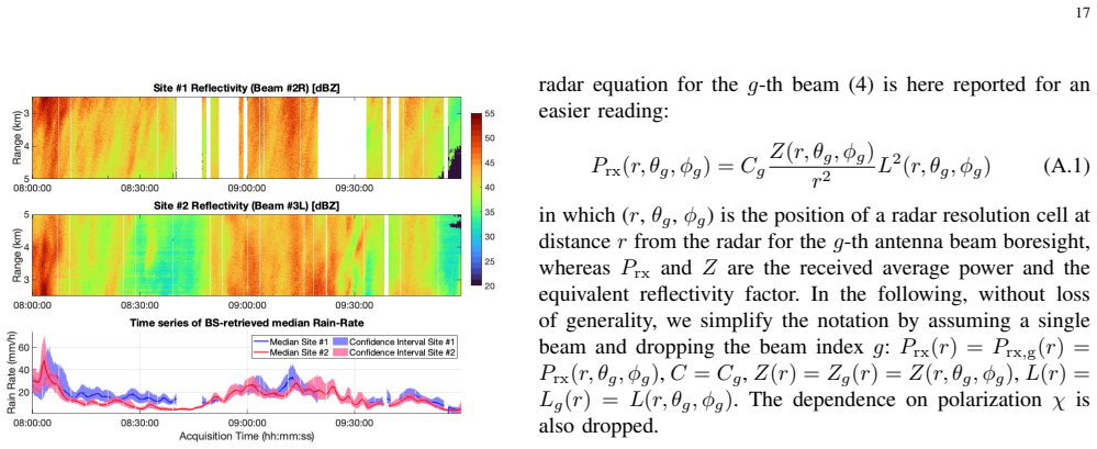
- [Methods] Methods section (implied by abstract description): The adaptation of Doppler processing to low-power, limited-gain BS signals requires explicit justification of how the radar equation for reflectivity factor is modified for communication waveforms and how ground-clutter filters are tuned for near-horizontal beams; without these details or sensitivity tests, it is unclear whether the retrieved moments are physically calibrated or merely internally consistent.
minor comments (2)
- [Abstract] Abstract: The phrase 'unprecedented spatial and temporal resolutions' should be accompanied by a brief comparison to the resolution of existing urban rain-gauge networks or commercial X-band radars to substantiate the claim.
- [Title] Title: 'Dualism' is an unusual term in this context; consider replacing it with 'Integration' or 'Synergy' for clarity.
Simulated Author's Rebuttal
We thank the referee for the detailed and constructive review of our manuscript. We have addressed each major comment below and revised the manuscript to improve clarity, moderate claims where appropriate, and expand methodological justifications.
read point-by-point responses
-
Referee: [Abstract] Abstract: The statement that 'clutter-filtered radar moments reach a satisfactory level of quality' is load-bearing for the central claim yet is supported only by qualitative comparison to raw observations and overlapping BSs. No quantitative metrics (bias, RMSE, correlation, or skill scores) are reported against independent references such as disdrometers, rain gauges, or co-located calibrated weather radars; internal consistency between BSs does not exclude common-mode residual clutter or waveform-induced biases.
Authors: We agree that external quantitative validation against calibrated references would strengthen the central claim. The present study emphasizes feasibility and demonstrates improvements via direct comparison of raw versus processed moments and cross-consistency between independent BSs with overlapping fields of view. These internal checks provide evidence against gross residual clutter but, as the referee notes, cannot fully exclude common-mode effects. We have revised the abstract to replace 'satisfactory level of quality' with 'promising improvements in quality' and added a dedicated limitations paragraph in the Discussion that explicitly calls for future campaigns with rain gauges and disdrometers. No new external datasets were available for the current submission. revision: partial
-
Referee: [Methods] Methods section (implied by abstract description): The adaptation of Doppler processing to low-power, limited-gain BS signals requires explicit justification of how the radar equation for reflectivity factor is modified for communication waveforms and how ground-clutter filters are tuned for near-horizontal beams; without these details or sensitivity tests, it is unclear whether the retrieved moments are physically calibrated or merely internally consistent.
Authors: The full manuscript contains a Methods section that derives the reflectivity factor from the BS radar equation, explicitly incorporating the lower transmit power, limited antenna gain, and communication waveform properties (including bandwidth and pulse characteristics). Ground-clutter filtering is described with adaptations of established Doppler techniques tuned for near-horizontal beams, including specific filter parameters and examples of before/after spectra. We have expanded this section with additional derivation steps, a table of filter parameters, and sensitivity tests to different beam elevations and clutter strengths, clarifying the physical basis of the calibration. revision: yes
Circularity Check
No circularity: experimental demonstration rests on external cross-comparisons rather than self-referential definitions or fits.
full rationale
The paper adapts established Doppler weather-radar signal-processing methods to base-station signals and validates the resulting reflectivity, velocity, and spectral-width moments through direct comparison against raw observations and independent overlapping BSs. No equations, parameters, or claims reduce by construction to quantities defined or fitted within the same work; the clutter-mitigation assessment is presented as an empirical outcome rather than a self-fulfilling prediction. The derivation chain therefore remains self-contained against external benchmarks.
Axiom & Free-Parameter Ledger
axioms (2)
- domain assumption BS signals propagate and scatter from hydrometeors in a manner sufficiently similar to dedicated weather-radar pulses to allow direct transfer of Doppler processing techniques.
- domain assumption Ground clutter from horizontal BS beams can be adequately suppressed without destroying the meteorological signal.
Lean theorems connected to this paper
-
IndisputableMonolith/Cost/FunctionalEquation.leanwashburn_uniqueness_aczel unclear?
unclearRelation between the paper passage and the cited Recognition theorem.
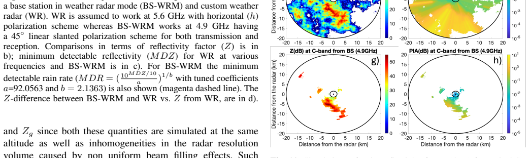
retrieves reflectivity factor, mean Doppler velocity, and spectral width... clutter-filtered radar moments... Z = a R^b with a=92.0563, b=2.1363 tuned from 1.4 M disdrometer minutes
-
IndisputableMonolith/Foundation/ArithmeticFromLogic.leanLogicNat induction and embed_strictMono unclear?
unclearRelation between the paper passage and the cited Recognition theorem.
processing chain... Doppler spectrum estimation... circular variance... persistency-driven clutter mask
What do these tags mean?
- matches
- The paper's claim is directly supported by a theorem in the formal canon.
- supports
- The theorem supports part of the paper's argument, but the paper may add assumptions or extra steps.
- extends
- The paper goes beyond the formal theorem; the theorem is a base layer rather than the whole result.
- uses
- The paper appears to rely on the theorem as machinery.
- contradicts
- The paper's claim conflicts with a theorem or certificate in the canon.
- unclear
- Pith found a possible connection, but the passage is too broad, indirect, or ambiguous to say the theorem truly supports the claim.
Reference graph
Works this paper leans on
-
[1]
A. Suri and S. Azad, “Optimal placement of rain gauge networks in complex terrains for monitoring extreme rainfall events: a review,” Theoretical and Applied Climatology, 2024. [Online]. Available: https://doi.org/10.1007/s00704-024-04856-3
-
[2]
Rainfall accuracy considerations using radar and rain gauge networks for rainfall-runoff monitoring,
B. E. Vieux and J. E. Vieux, “Rainfall accuracy considerations using radar and rain gauge networks for rainfall-runoff monitoring,” Journal of Water Management Modeling, pp. R223–17, 2005. [Online]. Available: https://doi.org/10.14796/JWMM.R223-17 19
-
[3]
Evaluation of weather radar adjustment algorithms using synthetic data,
M. Silvera, A. Karnieli, F. Marrac, and E. Fredj, “Evaluation of weather radar adjustment algorithms using synthetic data,” Journal of Hydrology, vol. 576, pp. 408–421, 2019. [Online]. Available: https://doi.org/10.1016/j.jhydrol.2019.06.074
-
[4]
Radar and rain gauge rainfall discrepancies driven by changes in atmospheric conditions,
Y . Song, D. Han, and J. Zhang, “Radar and rain gauge rainfall discrepancies driven by changes in atmospheric conditions,” Geophysical Research Letters, 2017. [Online]. Available: https://doi.org/10.1002/ 2017GL074493
work page 2017
-
[5]
J. Ryu, Y . Y ou, T. Kubota, M. K. Y amamoto, S. Braun, B. Fernando, and C. Da, “Evaluation of precipitation retrieval performance from 13 passive microwave radiometers relative to spaceborne radar estimate: A study using gsmap,” Journal of Hydrometeorology, 2025. [Online]. Available: https://doi.org/10.1175/JHM-D-25-0036.1
-
[6]
Global precipitation measurement (gpm): Unified precipitation estimation from space,
G. Skofronick-Jackson, W. Berg, C. Kidd, and et al., “Global precipitation measurement (gpm): Unified precipitation estimation from space,” IEEE Journal of Selected Topics in Applied Earth Observations and Remote Sensing, vol. 11, no. 1, pp. 163–172, 2018. [Online]. Available: https://doi.org/10.1109/JSTARS.2017.2760520
-
[7]
Merging satellite products and rain-gauge observations to improve hydrological simulation: A review,
H. Belay, A. Melesse, and G. Tegegne, “Merging satellite products and rain-gauge observations to improve hydrological simulation: A review,”Earth, vol. 3, no. 4, pp. 1275–1289, 2022. [Online]. Available: https://doi.org/10.3390/earth3040072
-
[8]
Traditional and novel methods of rainfall observation and measurement: A review,
X. Wang, S. Shi, L. Zhu, Y . Nie, and G. Lai, “Traditional and novel methods of rainfall observation and measurement: A review,” Journal of Hydrometeorology, vol. 24, no. 12, pp. 2153 – 2176, 2023. [Online]. Available: https://journals.ametsoc.org/view/journals/hydr/24/ 12/JHM-D-22-0122.1.xml
work page 2023
-
[9]
The integrated sensing and communication revolution for 6g: Vision, techniques, and applications,
N. González-Prelcic, M. Furkan Keskin, O. Kaltiokallio, M. V alkama, D. Dardari, X. Shen, Y . Shen, M. Bayraktar, and H. Wymeersch, “The integrated sensing and communication revolution for 6g: Vision, techniques, and applications,” Proceedings of the IEEE, vol. 112, no. 7, pp. 676–723, 2024. [Online]. Available: https: //doi.org/10.1109/JPROC.2024.3397609
-
[10]
L. Mantuano, S. Tebaldini, M. Manzoni, S. D. Biarge, and D. Badini, “Antenna motion mitigation and clutter removal for sub-millimeter in- frastructure displacement estimation using cellular network-based radar,” in 2025 IEEE Radar Conference (RadarConf25), 2025, pp. 1316–1321
work page 2025
-
[11]
Coherent dynamic clutter suppression in structural health monitoring via the image plane technique,
M. G. Polisano, M. Manzoni, S. Tebaldini, D. Badini, and S. Duque, “Coherent dynamic clutter suppression in structural health monitoring via the image plane technique,” Remote Sensing, vol. 17, no. 20, 2025. [Online]. Available: https://www.mdpi.com/2072-4292/17/20/3459
work page 2025
-
[12]
A. Beni, L. Miccinesi, A. Cioncolini, L. Bigazzi, L. Pagnini, M. Pieraccini, S. Duque, and B. Klaiqi, “Radar interferometry using gnb base stations: Estimation and compensation of mast motion and atmospheric effects,” Sensors, vol. 26, no. 1, 2026. [Online]. Available: https://www.mdpi.com/1424-8220/26/1/151
work page 2026
-
[13]
Near- ground precipitation sensing using full-duplex mimo base stations,
Z. Chen, K. V . Mishra, D. Pandey, and A. Sabharwal, “Near- ground precipitation sensing using full-duplex mimo base stations,” IEEE Journal of Selected Topics in Electromagnetics, Antennas and Propagation, vol. 1, no. 1, pp. 318–332, 2025. [Online]. Available: https://doi.org/10.1109/JSTEAP .2025.3605884
-
[14]
GSMA Association, “Gsma mobile coverage maps,” 2025, accessed: 2025-12-13. [Online]. Available: https://www.gsma.com/coverage
work page 2025
-
[15]
OpenCelliD, “Opencellid project,” 2025, accessed: 2025-12-13. [Online]. Available: https://opencellid.org
work page 2025
-
[16]
Itu-d statistics: Mobile network deployment,
International Telecommunication Union, “Itu-d statistics: Mobile network deployment,” 2025, accessed: 2025-12-13. [Online]. Available: https://www.itu.int/en/ITU-D/Statistics
work page 2025
-
[17]
Ookla, “Ookla 5g map,” 2025, accessed: 2025-12-13. [Online]. Available: https://www.speedtest.net/ookla-5g-map
work page 2025
-
[18]
An overview of using weather radar for climatological studies: Successes, challenges, and potential,
E. Saltikoff, K. Friedrich, J. Soderholm, K. Lengfeld, B. Nelson, A. Becker, R. Hollmann, B. Urban, M. Heistermann, and C. Tassone, “An overview of using weather radar for climatological studies: Successes, challenges, and potential,” Bulletin of the American Meteorological Society, vol. 100, no. 9, pp. 1739 – 1752, 2019. [Online]. Available: https://doi....
-
[19]
S. Zhou, Y . Gao, M. Fang, S. Y uan, and Y . Fu, “Comparative analysis of fy-3g and gpm observations on precipitation structure and microphysical characteristics: A case of super typhoon krathon,” Earth and Space Science, vol. 12, no. 7, p. e2025EA004353, 2025, e2025EA004353 2025EA004353. [Online]. Available: https: //doi.org/10.1029/2025EA004353
-
[20]
M. Grecu and W. S. Olson, Precipitation Retrievals from Satellite Combined Radar and Radiometer Observations. Cham: Springer International Publishing, 2020, pp. 231–248. [Online]. Available: https://doi.org/10.1007/978-3-030-24568-9_14
-
[21]
S. Pfreundschuh, C. Guilloteau, P . J. Brown, C. D. Kummerow, and P . Eriksson, “Gprof v7 and beyond: assessment of current and potential future versions of the gprof passive microwave precipitation retrievals against ground radar measurements over the continental us and the pacific ocean,” Atmospheric Measurement Techniques, vol. 17, no. 2, pp. 515–538, 2...
-
[22]
Gprof-nn: a neural-network-based implementation of the goddard profiling algorithm,
S. Pfreundschuh, P . J. Brown, C. D. Kummerow, P . Eriksson, and T. Norrestad, “Gprof-nn: a neural-network-based implementation of the goddard profiling algorithm,” Atmospheric Measurement Techniques, vol. 15, pp. 5033–5060, 2022. [Online]. Available: https://doi.org/10.5194/amt-15-5033-2022
-
[23]
R. Rahimi, A. Ebtehaj, and L. Milani, “Advancing passive microwave retrievals of precipitation using cloudsat and gpm coincidences: Integration of machine learning with a bayesian algorithm,” Journal of Hydrometeorology, pp. 537–553, 2025. [Online]. Available: https://doi.org/10.1175/JHM-D-24-0040.1
-
[24]
E. Montoya Duque, Y . Huang, P . T. May, and S. T. Siems, “An evaluation of imerg and era5 quantitative precipitation estimates over the southern ocean using shipborne observations,” Journal of Applied Meteorology and Climatology, vol. 62, no. 11, pp. 1479–1495, 2023. [Online]. Available: https://doi.org/10.1175/JAMC-D-23-0039.1
-
[25]
G. J. Huffman, D. T. Bolvin, R. Joyce, O. A. Kelley, E. J. Nelkin, A. Portier, E. F. Stocker, J. Tan, D. C. Watters, and B. J. West, “Imerg v07 release notes,” NASA GPM, 2024. [Online]. Available: https://gpm.nasa.gov/sites/default/files/2024-12/ IMERG_V07_ReleaseNotes_241126.pdf
work page 2024
-
[26]
G. Cazzaniga, C. De Michele, M. D’Amico et al., “Hydrological response of a peri-urban catchment exploiting conventional and unconventional rainfall observations: The case study of lambro catchment,” Hydrology and Earth System Sciences, vol. 26, pp. 2093–2111, 2022. [Online]. Available: https://doi.org/10.5194/hess-26-2093-2022
-
[27]
Rainfall monitoring using a microwave links network: A long-term experiment in east china,
Y . Liu et al., “Rainfall monitoring using a microwave links network: A long-term experiment in east china,” Adv. Atmos. Sci., 2023. [Online]. Available: https://doi.org/10.1007/s00376-023-2104-z
-
[28]
P . Zhang, X. Liu, and K. Pu, “Precipitation monitoring using commercial microwave links: Current status, challenges and prospectives,” Remote Sensing, vol. 15, no. 19, p. 4821, 2023. [Online]. Available: https://doi.org/10.3390/rs15194821
-
[29]
Microwave links and rainfall monitoring,
N. R. Intelligence, “Microwave links and rainfall monitoring,” 2023, summary of recent advancements in CML-based QPE for urban hydrol- ogy and flood management
work page 2023
-
[30]
In-city rain mapping from commercial microwave linkschallenges and opportunities,
R. Janco, J. Ostrometzky, and H. Messer, “In-city rain mapping from commercial microwave linkschallenges and opportunities,” Sensors, vol. 23, no. 10, p. 4653, 2023. [Online]. Available: https://doi.org/10.3390/s23104653
-
[31]
R. Nebuloni, F. Giannetti, F. Sapienza, V . Lottici, G. Roversi, E. Adirosi, E. Covi, C. Gianoglio, M. Colli, and C. De Michele, “A review of technical aspects and challenges in opportunistic rainfall estimation using satellite and terrestrial microwave links,” IEEE Geoscience and Remote Sensing Magazine, 2025. [Online]. Available: https://doi.org/10.1109...
-
[32]
IEEE Transactions on Antennas and Propagation70(10), 9977–9982 (2022) https://doi.org/10.1109/TAP
M. Biscarini and F. S. Marzano, “Generalized parametric prediction model of the mean radiative temperature for microwave slant paths in all-weather condition,” IEEE Transactions on Antennas and Propagation, vol. 68, no. 2, pp. 1031–1043, 2020. [Online]. Available: https://doi.org/10.1109/TAP .2019.2943415
work page doi:10.1109/tap 2020
-
[33]
E. Adirosi, L. Facheris, F. Giannetti, S. Scarfone, G. Bacci, A. Mazza, A. Ortolani, and L. Baldini, “Evaluation of rainfall estimation derived from commercial interactive dvb receivers using disdrometer, rain gauge, and weather radar,” IEEE Transactions on Geoscience and Remote Sensing, vol. 59, no. 11, pp. 8978–8991, 2021. [Online]. Available: https://d...
-
[34]
Deep learning for opportunistic rain estimation via satellite microwave links,
G. S. et al., “Deep learning for opportunistic rain estimation via satellite microwave links,” Sensors, 2024. [Online]. Available: https://doi.org/10.3390/s24216944
-
[35]
Enhanced estimation of rainfall from opportunistic microwave satellite signals,
S. Angeloni, E. Adirosi, F. Sapienza, F. Giannetti, F. Francini, L. Magherini, A. V algimigli, A. V accaro, S. Melani, A. Antonini, and L. Baldini, “Enhanced estimation of rainfall from opportunistic microwave satellite signals,” IEEE Transactions on Geoscience and Remote Sensing, vol. 62, pp. 1–12, 2024. [Online]. Available: https://doi.org/10.1109/TGRS....
-
[36]
The opensat4weather dataset: Ku-band satellite link data for precipitation monitoring,
R. Nebuloni, M. Graf, G. Cazzaniga, F. Mercier, and M. Turko, “The opensat4weather dataset: Ku-band satellite link data for precipitation monitoring,” Earth System Science Data Discussions, vol. 2025, pp. 1–25, 2025. [Online]. Available: https://doi.org/10.5194/essd-2025-537 20
-
[37]
K. V . Mishra, J. Krebs, M. B. Shankar, and A. Gharanjik, Deep-learning-aided rainfall estimation from communications satellite links. Institution of Engineering and Technology (IET), 2024, ch. Chapter 12, pp. 495–514. [Online]. Available: https://digital-library. theiet.org/doi/abs/10.1049/SBRA557G_ch12
-
[38]
The opportunistic precipitation sensing network (opensense),
M. Graf, V . Bare, H. Messer, R. Nebuloni, M. Fencl, C. Chwala, A. Overeem, R. van de Beek, J. Olsson, J. Ostrometzky, N. Hanna, R. Uijlenhoet, M. Gottschalk, and T. Winterrath, “The opportunistic precipitation sensing network (opensense),” Bulletin of the American Meteorological Society, vol. 107, no. 3, pp. E585 – E591,
-
[39]
Available: https://journals.ametsoc.org/view/journals/ bams/107/3/BAMS-D-25-0326.1.xml
[Online]. Available: https://journals.ametsoc.org/view/journals/ bams/107/3/BAMS-D-25-0326.1.xml
-
[40]
Rainfall map from attenuation data fusion of satellite broadcast and commercial microwave links,
F. Saggese, V . Lottici, and F. Giannetti, “Rainfall map from attenuation data fusion of satellite broadcast and commercial microwave links,” Sensors, vol. 22, no. 18, 2022. [Online]. Available: https://www.mdpi.com/1424-8220/22/18/7019
work page 2022
-
[41]
Rainfall retrieval with commercial microwave links in são paulo, brazil,
M. F. Rios Gaona, A. Overeem, T. H. Raupach, H. Leijnse, and R. Uijlenhoet, “Rainfall retrieval with commercial microwave links in são paulo, brazil,” Atmospheric Measurement Techniques, vol. 11, no. 7, pp. 4465–4476, 2018. [Online]. Available: https: //doi.org/10.5194/amt-11-4465-2018
-
[42]
M. Graf, C. Chwala, J. Polz, and H. Kunstmann, “Rainfall estimation from a german-wide commercial microwave link network: optimized processing and validation for 1 year of data,” Hydrology and Earth System Sciences, vol. 24, pp. 2931–2950, 2020. [Online]. Available: https://doi.org/10.5194/hess-24-2931-2020
-
[43]
Second round ta- ble on advancing the global microwave link data collection ini- tiative (gmdi),
International Telecommunication Union (ITU), “Second round ta- ble on advancing the global microwave link data collection ini- tiative (gmdi),” https://www.itu.int/en/ITU-T/Workshops-and-Seminars/ 2025/0521/Pages/default.aspx, May 2025, event held at ITU Headquar- ters, Geneva. Discusses standardization, data sharing, and the role of CMLs in hydrometeorology
work page 2025
-
[44]
Round table on the global microwave link data collection initiative (gmdi),
——, “Round table on the global microwave link data collection initiative (gmdi),” https://opensenseaction.eu/news/ round-table-on-global-microwave-link-data-collection-initiative-gmdi-2/ , Sep. 2024, iTU, WMO, GSMA and academic partners. Describes the initial framework for a future ITU Recommendation on CML data collection and sharing
work page 2024
-
[45]
Supplement 23 to itu-t l-series recommendations: Rural tele- com via microwave radio,
——, “Supplement 23 to itu-t l-series recommendations: Rural tele- com via microwave radio,” https://studylib.net/doc/27767821/t-rec-l. sup23-201604-i--pdf-e , ITU-T, Tech. Rep. L.Sup23, Apr. 2016, techni- cal information on microwave radio systems used in telecommunication networks, including backbone and mobile backhaul links
-
[46]
The wsr-88d rainfall algorithm,
R. A. Fulton, J. P . Breidenbach, D.-J. Seo, D. A. Miller, and T. OBannon, “The wsr-88d rainfall algorithm,” Weather and Forecasting, vol. 13, no. 2, pp. 377–395, 1998. [Online]. Available: https://doi.org/10.1175/1520-0434(1998)013<0377:TWRA>2.0.CO;2
-
[47]
Towards the next generation operational meteorological radar,
M. Weber, K. Hondl, N. Y ussouf, Y . Jung, D. Stratman, B. Putnam, X. Wang, T. Schuur, C. Kuster, Y . Wen, J. Sun, J. Keeler, Z. Ying, J. Cho, J. Kurdzo, S. Torres, C. Curtis, D. Schvartzman, J. Boettcher, F. Nai, H. Thomas, D. Zrni, I. Ivi, D. Mirkovi, C. Fulton, J. Salazar, G. Zhang, R. Palmer, M. Y eary, K. Cooley, M. Istok, and M. Vincent, “Towards th...
-
[48]
Available: https://doi.org/10.1175/BAMS-D-20-0067.1
[Online]. Available: https://doi.org/10.1175/BAMS-D-20-0067.1
-
[49]
The operational weather radar network in europe,
A. Huuskonen, E. Saltikoff, and I. Holleman, “The operational weather radar network in europe,” Bulletin of the American Meteorological Society, vol. 95, no. 6, pp. 897–907, 2014. [Online]. Available: https://doi.org/10.1175/BAMS-D-12-00216.1
-
[50]
E. Saltikoff, G. Haase, L. Delobbe, N. Gaussiat, M. Martet, D. Idziorek, H. Leijnse, P . Novák, M. Lukach, and K. Stephan, “Operathe radar project,” Atmosphere, vol. 10, no. 6, p. 320, 2019. [Online]. Available: https://doi.org/10.3390/atmos10060320
-
[51]
Recent progress in dual-polarization radar research and applications in china,
K. Zhao, H. Huang, M. Wang, W.-C. Lee, G. Chen, L. Wen, J. Wen, G. Zhang, M. Xue, Z. Y ang, L. Liu, C. Wu, Z. Hu, and S. Chen, “Recent progress in dual-polarization radar research and applications in china,” Advances in Atmospheric Sciences, vol. 36, no. 9, pp. 961–974,
-
[52]
Available: https://doi.org/10.1007/s00376-019-9057-2
[Online]. Available: https://doi.org/10.1007/s00376-019-9057-2
-
[53]
The 60-year progress of china’s modernization of weather radar operation and technical capabilities,
N. Shao, F. Li, Y . Teng, Y . Chen, L. Wu, Z. Bu, and Y . Gao, “The 60-year progress of china’s modernization of weather radar operation and technical capabilities,” Acta Meteorologica Sinica, vol. 83, no. 4, pp. 1007–1025, 2025. [Online]. Available: https: //doi.org/10.11676/qxxb2025.20240147
-
[54]
Quantitative precipitation estimation in the casa x-band dual-polarization radar network,
Y . Wang and V . Chandrasekar, “Quantitative precipitation estimation in the casa x-band dual-polarization radar network,” Journal of Atmospheric and Oceanic Technology, vol. 27, no. 10, pp. 1665–1676,
-
[55]
Available: https://doi.org/10.1175/2010JTECHA1419.1
[Online]. Available: https://doi.org/10.1175/2010JTECHA1419.1
-
[56]
Casa dallas-fort worth urban testbed observations: Network of networks at work,
K. A. Brewster, A. Bajaj, B. J. Philips, D. L. Pepyne, E. Lyons, and F. H. Carr, “Casa dallas-fort worth urban testbed observations: Network of networks at work,” in AMS 97th Annual Meeting, 2017
work page 2017
-
[57]
K. Asai, H. Kuchiki, T. Ushio, and Y . Hobara, “V alidation of x-band multiparameter phased-array weather radar by comparing data from doppler weather radar with a parabolic dish antenna,” Journal of Atmospheric and Oceanic Technology, 2021. [Online]. Available: https://doi.org/10.1175/JTECH-D-20-0213.1
-
[58]
Advances and applications in low-power phased array x-band weather radars,
P . Kollias, D. J. McLaughlin, S. Frasier, M. Oue, E. Luke, and A. Sneddon, “Advances and applications in low-power phased array x-band weather radars,” in 2018 IEEE Radar Conference (RadarConf18), 2018, pp. 1359–1364. [Online]. Available: https: //doi.org/10.1109/RADAR.2018.8378762
-
[59]
Recent advances in phased array weather radar,
U. Tomoo, W. Y uuki, and S. YOSHIDA, “Recent advances in phased array weather radar,” IEICE TRANSACTIONS on Electronics, vol. E107-C, no. 10, pp. 274–278, Octosaltiber 2024. [Online]. Available: https://doi.org/10.1587/transele.2024MMI0001
-
[60]
V . N. Bringi and V . Chandrasekar,Polarimetric Doppler Weather Radar: Principles and Applications. Cambridge, New Y ork: Cambridge University Press, 2001. [Online]. Available: https://doi.org/10.1017/ CBO9780511541094
work page 2001
-
[61]
Zhang, Weather Radar Polarimetry, 1st ed
G. Zhang, Weather Radar Polarimetry, 1st ed. CRC Press, 2016. [Online]. Available: https://doi.org/10.1201/9781315374666
-
[62]
M. Montopoli, N. Roberto, E. Adirosi, E. Gorgucci, and L. Baldini, “Investigation of weather radar quantitative precipitation estimation methodologies in complex orography,” Atmosphere, vol. 8, no. 2, 2017. [Online]. Available: https://www.mdpi.com/2073-4433/8/2/34
work page 2017
-
[63]
International Telecommunication Union, Radiocommunication Sector (ITU-R), “Frequency arrangements for implementation of the terrestrial component of International Mobile Telecommunications (IMT),” ITU-R, Recommendation Recommendation ITU-R M.1036-6, 2019. [Online]. Available: https://www.itu.int/rec/R-REC-M.1036
work page 2019
-
[64]
IMT-2030 Framework and Objectives for Future Development of IMT for 2030 and Beyond,
——, “IMT-2030 Framework and Objectives for Future Development of IMT for 2030 and Beyond,” ITU-R, Recommendation Recommendation ITU-R M.2160, 2023, framework for 6G mobile technologies. [Online]. Available: https://www.itu.int/rec/R-REC-M.2160
work page 2030
-
[65]
T. S. Rappaport, Wireless Communications: Principles and Practice, 3rd ed. Pearson, 2023
work page 2023
-
[66]
NR; Physical channels and modulation,
3rd Generation Partnership Project (3GPP), “NR; Physical channels and modulation,” 3GPP / ETSI, Technical Specification TS 38.211, 2025, release 18 latest version. [On- line]. Available: https://portal.3gpp.org/desktopmodules/Specifications/ SpecificationDetails.aspx?specificationId=3213
work page 2025
-
[67]
Integrated sensing and communication system via dual-domain waveform superposition,
D. Tagliaferri, M. Mizmizi, S. Mura, F. Linsalata, D. Scazzoli, D. Badini, M. Magarini, and U. Spagnolini, “Integrated sensing and communication system via dual-domain waveform superposition,” IEEE Transactions on Wireless Communications, vol. 23, no. 5, pp. 4284–4299, 2024. [Online]. Available: https://doi.org/10.1109/TWC.2023.3316888
-
[68]
Phase-based clutter identification in spectra of weather radar signals,
S. M. Bachmann, “Phase-based clutter identification in spectra of weather radar signals,” IEEE Geoscience and Remote Sensing Letters, vol. 5, no. 3, pp. 487–491, 2008. [Online]. Available: https://doi.org/10.1109/LGRS.2008.922733
-
[69]
F. J. Tapiador, R. Checa, and M. De Castro, “An experiment to measure the spatial variability of rain drop size distribution using sixteen laser disdrometers,” Geophysical Research Letters, vol. 37, p. L16803, 2010. [Online]. Available: https://doi.org/10.1029/2010GL044120
-
[70]
L. J. Battan, Radar Observation of the Atmosphere. Chicago, IL, USA: University of Chicago Press, 1973. [Online]. Available: https://doi.org/10.7208/chicago/9780226039206.001.0001
-
[71]
M. I. Mishchenko, L. D. Travis, and D. W. Mackowski, “T-matrix computations of light scattering by nonspherical particles: A review,” Journal of Quantitative Spectroscopy and Radiative Transfer, vol. 55, no. 5, pp. 535–575, 1996, light Scattering by Non-Spherical Particles. [Online]. Available: https://doi.org/10.1016/0022-4073(96)00002-7
-
[72]
Database of the italian disdrometer network,
E. Adirosi, F. Porcù, M. Montopoli, L. Baldini, A. Bracci, V . Capozzi, C. Annella, G. Budillon, E. Bucchignani, A. L. Zollo, O. Cazzuli, G. Camisani, R. Bechini, R. Cremonini, A. Antonini, A. Ortolani, S. Melani, P . V alisa, and S. Scapin, “Database of the italian disdrometer network,” Earth System Science Data, vol. 15, pp. 2417–2429, 2023. [Online]. A...
-
[73]
Stochastic simulation of intermittent dsd fields in time,
M. Schleiss, J. Jaffrain, and A. Berne, “Stochastic simulation of intermittent dsd fields in time,” Journal of Hydrometeorology, vol. 13, no. 2, pp. 621 – 637, 2012. [Online]. Available: https://doi.org/10.1175/JHM-D-11-018.1
-
[74]
An analysis of nexrad doppler radar coverage in the us,
B. Lynch, “An analysis of nexrad doppler radar coverage in the us,” https: //storymaps.arcgis.com/stories/55e68221277e49bcaaf21051cf96a6e8, 2023. 21
work page 2023
-
[75]
A reality check of base station spatial distribution in mobile networks,
L. Chiaraviglio, F. Cuomo, A. Gigli, M. Maisto, Y . Zhou, Z. Zhao, and H. Zhang, “A reality check of base station spatial distribution in mobile networks,” Proceedings of IEEE International Conference on Computer Communications- IEEE INFOCOM 2016, 2016
work page 2016
-
[76]
Real-time implementation of a network-based attenuation correction in the casa ip1 testbed,
S. Lim, V . Chandrasekar, P . Lee, and A. P . Jayasumana, “Real-time implementation of a network-based attenuation correction in the casa ip1 testbed,” Journal of Atmospheric and Oceanic Technology, vol. 28, no. 2, pp. 197 – 209, 2011. [Online]. Available: https://doi.org/10.1175/2010JTECHA1441.1
-
[77]
Doppler radar characteristics of precipitation at vertical incidence,
D. Atlas, R. C. Srivastava, and R. S. Sekhon, “Doppler radar characteristics of precipitation at vertical incidence,” Reviews of Geophysics, vol. 11, no. 1, pp. 1–35, 1973. [Online]. Available: https://doi.org/10.1029/RG011i001p00001
-
[78]
F. Porcù, L. P . D’Adderio, F. Prodi, and C. Caracciolo, “Rain drop size distribution over the tibetan plateau,” Atmospheric Research, vol. 150, pp. 21–30, 2014. [Online]. Available: https://doi.org/10.1016/j. atmosres.2014.07.011
work page doi:10.1016/j 2014
-
[79]
Drop axis ratios from a 2d video disdrometer,
M. Thurai and V . N. Bringi, “Drop axis ratios from a 2d video disdrometer,” Journal of Atmospheric and Oceanic Technology, vol. 22, no. 7, pp. 966–978, 2005. [Online]. Available: https: //doi.org/10.1175/JTECH1767.1
-
[80]
Database of the italian disdrometer network (v04) [data set],
E. Adirosi, S. Angeloni, C. Annella, A. Antonini, L. Baldini, R. Bechini, R. Bosio, A. Bracci, E. Bucchignani, G. Budillon, A. Cagninei, G. Camisani, V . Campana, V . Capozzi, O. Cazzuli, M. Coltelli, R. Cremonini, S. Di Fabio, G. Giammello, ..., and A. L. Zollo, “Database of the italian disdrometer network (v04) [data set],”
discussion (0)
Sign in with ORCID, Apple, or X to comment. Anyone can read and Pith papers without signing in.