GreenScatter: Through-Canopy Soil Moisture Sensing with UAV-Mounted Radar
Pith reviewed 2026-05-10 16:34 UTC · model grok-4.3
The pith
GreenScatter retrieves accurate soil moisture from UAV radar through dense canopy using a new physics model.
A machine-rendered reading of the paper's core claim, the machinery that carries it, and where it could break.
Core claim
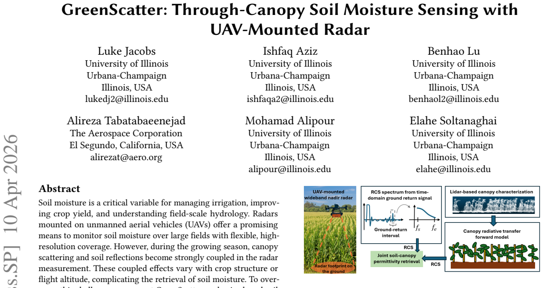
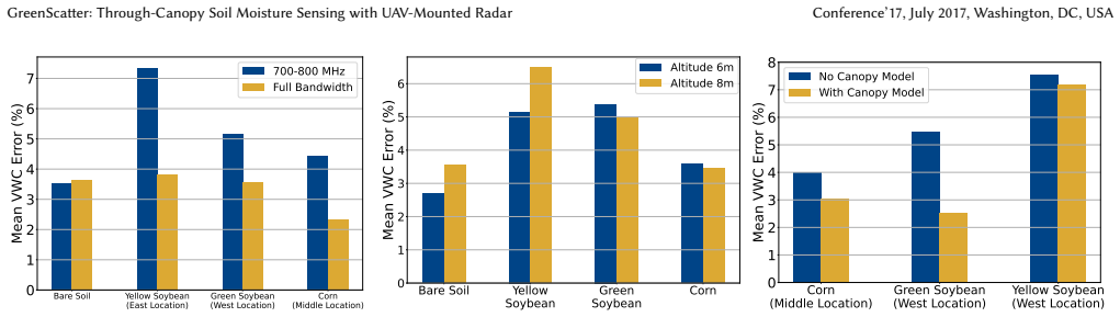
GreenScatter introduces a microwave radiative transfer model that explicitly captures the dominant electromagnetic interactions between vegetation and soil, enabling accurate modeling of coherent ground backscatter through canopy. In parallel, it develops a radar cross-section (RCS) estimation method that transforms time-domain radar signals into calibrated wideband RCS spectra, isolating soil reflections while compensating for hardware and waveform effects. Together, these components enable robust soil moisture estimation through vegetation across varying canopy conditions and UAV configurations. Field experiments across multiple corn and soybean sites demonstrate consistent retrieval with
What carries the argument
The microwave radiative transfer model for vegetation-soil interactions and the RCS estimation method for isolating calibrated soil backscatter spectra from radar signals.
Load-bearing premise
The dominant electromagnetic interactions between vegetation and soil are correctly described by the radiative transfer model, and the signal processing isolates soil reflections without significant remaining biases from canopy or hardware.
What would settle it
A set of independent ground truth measurements of volumetric water content taken simultaneously with UAV flights over the same sites, where the difference between estimated and measured values exceeds the reported error substantially.
Figures


read the original abstract
Soil moisture is a critical variable for managing irrigation, improving crop yield, and understanding field-scale hydrology. Radars mounted on unmanned aerial vehicles (UAVs) offer a promising means to monitor soil moisture over large fields with flexible, high-resolution coverage. However, during the growing season, canopy scattering and soil reflections become strongly coupled in the radar measurement. These coupled effects vary with crop structure or flight altitude, complicating the retrieval of soil moisture. To overcome this challenge, we present GreenScatter, a physics-based soil moisture retrieval framework for nadir-looking wideband UAV radars. GreenScatter introduces a microwave radiative transfer model that explicitly captures the dominant electromagnetic interactions between vegetation and soil, enabling accurate modeling of coherent ground backscatter through canopy. In parallel, it develops a radar cross-section (RCS) estimation method that transforms time-domain radar signals into calibrated wideband RCS spectra, isolating soil reflections while compensating for hardware and waveform effects. Together, these components enable robust soil moisture estimation through vegetation across varying canopy conditions and UAV configurations. Field experiments across multiple corn and soybean sites demonstrate consistent retrieval with an average volumetric water content (VWC) error of 4.49%.
Editorial analysis
A structured set of objections, weighed in public.
Referee Report
Summary. The manuscript presents GreenScatter, a physics-based soil moisture retrieval framework for nadir-looking wideband UAV radars. It introduces a microwave radiative transfer model that explicitly captures dominant electromagnetic interactions between vegetation and soil to model coherent ground backscatter through canopy. It also develops an RCS estimation method that transforms time-domain radar signals into calibrated wideband RCS spectra, isolating soil reflections while compensating for hardware and waveform effects. Field experiments across multiple corn and soybean sites report consistent retrieval with an average volumetric water content (VWC) error of 4.49%.
Significance. If the model and calibration hold, the work could advance practical UAV-based soil moisture monitoring under canopy cover, supporting applications in irrigation management and field-scale hydrology. The explicit physics-based modeling of vegetation-soil interactions combined with hardware compensation and multi-site field results with a concrete error metric represent a clear strength for reproducibility and applicability.
major comments (2)
- Abstract: The central claim of robust retrieval with 4.49% average VWC error from multi-site tests on corn and soybean is load-bearing, yet the abstract provides no details on ground-truth comparison methods, error bars, or data exclusion criteria. This prevents verification that the reported performance is not affected by unstated post-hoc choices or unmodeled effects.
- RCS estimation method: The description states that the method isolates soil reflections while compensating for hardware, waveform, and canopy effects, but without the explicit transformation equations or calibration steps shown, it is not possible to confirm that biases are avoided across varying canopy conditions and UAV altitudes.
minor comments (2)
- Abstract: Specify the frequency range or bandwidth of the wideband radar to contextualize the radiative transfer model assumptions.
- The manuscript should include an ablation study or sensitivity analysis on the radiative transfer model parameters to demonstrate robustness.
Simulated Author's Rebuttal
We thank the referee for the constructive and detailed feedback. We address each major comment below and have revised the manuscript to improve clarity and completeness where the concerns are valid.
read point-by-point responses
-
Referee: Abstract: The central claim of robust retrieval with 4.49% average VWC error from multi-site tests on corn and soybean is load-bearing, yet the abstract provides no details on ground-truth comparison methods, error bars, or data exclusion criteria. This prevents verification that the reported performance is not affected by unstated post-hoc choices or unmodeled effects.
Authors: We agree that the abstract would benefit from additional context on the validation approach. In the revised manuscript we have expanded the abstract to briefly note the use of in-situ sensor measurements for ground-truth VWC, the averaging of errors across the corn and soybean sites, and the reporting of standard deviations. Data exclusion criteria (low-SNR signals) are now also referenced in the abstract and remain fully detailed in the experimental methods section. revision: yes
-
Referee: RCS estimation method: The description states that the method isolates soil reflections while compensating for hardware, waveform, and canopy effects, but without the explicit transformation equations or calibration steps shown, it is not possible to confirm that biases are avoided across varying canopy conditions and UAV altitudes.
Authors: The RCS estimation procedure, including time-to-frequency transformation and hardware/waveform compensation, is described in Section III. To allow direct verification of bias avoidance, we have added the explicit transformation equations, the calibration steps using reference targets, and the integration with the radiative transfer model in the revised text. A new sensitivity analysis addressing canopy density and altitude variations has also been included. revision: yes
Circularity Check
No significant circularity; derivation is self-contained physics model plus calibration
full rationale
The paper presents a microwave radiative transfer model for vegetation-soil interactions and a separate RCS estimation pipeline that transforms time-domain signals into calibrated spectra. These are described as explicit physical modeling and hardware/waveform compensation steps, respectively, followed by field validation reporting a concrete VWC error metric. No equations or steps in the provided description reduce a claimed prediction to a fitted parameter by construction, nor does the central claim rest on self-citation chains or imported uniqueness theorems. The framework is therefore independent of its own outputs.
Axiom & Free-Parameter Ledger
axioms (1)
- domain assumption Standard electromagnetic assumptions in microwave radiative transfer for canopy and soil layers
Reference graph
Works this paper leans on
-
[1]
[n. d.]. TEROS 12 - METER Group. https://metergroup.com/products/teros-12/ GreenScatter: Through-Canopy Soil Moisture Sensing with UAV-Mounted Radar Conference’17, July 2017, Washington, DC, USA
work page 2017
-
[2]
Ishfaq Aziz, Elahe Soltanaghai, Adam Watts, and Mohamad Alipour. 2024. Bayesian inversion of GPR waveforms for sub-surface material characteriza- tion: An uncertainty-aware retrieval of soil moisture and overlaying biomass properties.Remote Sensing of Environment313 (Nov. 2024), 114351. doi:10.1016/j. rse.2024.114351
work page doi:10.1016/j 2024
-
[3]
Martin Béland et al . 2021. Mapping forest leaf area density from multiview terrestrial lidar.Methods in Ecology and Evolution12, 12 (2021), 2543–2560. doi:10.1111/2041-210X.13550
-
[4]
Martin Béland, Jean-Luc Widlowski, and Richard A. Fournier. 2014. On seeing the wood from the leaves and the role of voxel size in determining leaf area distribution of forests with terrestrial LiDAR.Remote Sensing of Environment140 (2014), 1–13. doi:10.1016/j.rse.2013.08.047
-
[5]
Craig F. Bohren and Donald R. Huffman. 2008.Absorption and Scattering of Light by Small Particles. John Wiley & Sons. Google-Books-ID: ib3EMXXIRXUC
work page 2008
-
[6]
Laura L Bourgeau-Chavez, Brigitte Leblon, Francois Charbonneau, and Joseph R Buckley. 2013. Evaluation of polarimetric Radarsat-2 SAR data for development of soil moisture retrieval algorithms over a chronosequence of black spruce boreal forests.Remote Sensing of Environment132 (2013), 71–85
work page 2013
-
[7]
Mariko Burgin, Daniel Clewley, Richard M. Lucas, and Mahta Moghaddam. 2011. A Generalized Radar Backscattering Model Based on Wave Theory for Multilayer Multispecies Vegetation.IEEE Transactions on Geoscience and Remote Sensing49, 12 (Dec. 2011), 4832–4845. doi:10.1109/TGRS.2011.2172949
-
[8]
Qinbo Cheng, Qiuju Su, Andrew Binley, Jintao liu, Zhicai Zhang, and Xi Chen
-
[9]
doi:10.1029/ 2022WR032621 Publisher: John Wiley and Sons Inc
Estimation of Surface Soil Moisture by a Multi-Elevation UAV-Based Ground Penetrating Radar.Water Resources Research59, 2 (2023). doi:10.1029/ 2022WR032621 Publisher: John Wiley and Sons Inc
work page 2023
-
[10]
J. Choi, S. Chung, and H. Park. 2023. Application of LiDAR Sensors for Crop and Working Environment Recognition in Agriculture: A Review.Remote Sensing16, 24 (2023), 4623. doi:10.3390/rs16244623
-
[11]
Rong Ding, Haiming Jin, Dong Xiang, Xiaocheng Wang, Yongkui Zhang, Ding- man Shen, Lu Su, Wentian Hao, Mingyuan Tao, Xinbing Wang, and Chenghu Zhou. 2023. Soil Moisture Sensing with UAV-Mounted IR-UWB Radar and Deep Learning.Proc. ACM Interact. Mob. Wearable Ubiquitous Technol.7, 1 (March 2023), 11:1–11:25. doi:10.1145/3580867
-
[12]
2025.GPSoil: Towards low-cost soil moisture sensing using GNSS signals
Huixin Dong, Jingqi Lin, Minhao Cui, Serene Zhang, Lili Qiu, Jie Xiong, and Wei Wang. 2025.GPSoil: Towards low-cost soil moisture sensing using GNSS signals. Association for Computing Machinery, New York, NY, USA, 635–649. https://doi-org.proxy2.library.illinois.edu/10.1145/3680207.3765236
-
[13]
S.L. Durden, J.J. van Zyl, and H.A. Zebker. 1989. Modeling and observation of the radar polarization signature of forested areas.IEEE Transactions on Geoscience and Remote Sensing27, 3 (May 1989), 290–301. doi:10.1109/36.17670
-
[14]
Florian J. Fischer, J. E. Pfeifer, J. H. Wackrow, and C. Hopkinson. 2024. Robust characterisation of forest structure from airborne laser and digital aerial pho- togrammetry data across boreal forest types.Methods in Ecology and Evolution 15, 4 (2024), 753–767. doi:10.1111/2041-210X.14416
-
[15]
Anke Fluhrer, Thomas Jagdhuber, Carsten Montzka, Maike Schumacher, Hamed Alemohammad, Alireza Tabatabaeenejad, Harald Kunstmann, and Dara En- tekhabi. 2024. Soil moisture profile estimation by combining P-band SAR po- larimetry with hydrological and multi-layer scattering models.Remote Sensing of Environment305 (May 2024), 114067. doi:10.1016/j.rse.2024.114067
-
[16]
A. Fung and Hyo Eom. 1983. Coherent scattering of a spherical wave from an irregular surface.IEEE Transactions on Antennas and Propagation31, 1 (Jan. 1983), 68–72. doi:10.1109/TAP.1983.1142979
-
[17]
X. Guo, J. Li, and T. Wang. 2024. A Comprehensive Review of LiDAR Applications in Crop Management and Phenotyping.Sensors24, 16 (2024), 5409. doi:10.3390/ s24165409
work page 2024
-
[18]
Irena Hajnsek, Eric Pottier, and Shane R Cloude. 2003. Inversion of surface parameters from polarimetric SAR.IEEE Transactions on Geoscience and Remote Sensing41, 4 (2003), 727–744
work page 2003
-
[19]
Mukuka Haluboka, Bryan N. Bailey, Walter F. Mahaffee, John A. Shaw, and Lee A. Vierling. 2021. Errors in the Estimation of Leaf Area Density from Aerial LiDAR Data: Influence of Statistical Sampling and Heterogeneity.IEEE Transactions on Geoscience and Remote Sensing59, 12 (2021), 10367–10377. doi:10.1109/TGRS. 2021.3123088
-
[20]
Thomas Jagdhuber, Irena Hajnsek, Stefan Sauer, Konstantinos P Papathanassiou, and Axel Bronstert. 2012. Soil moisture retrieval under forest using polarimetric decomposition techniques at P-band. InEUSAR 2012; 9th European Conference on Synthetic Aperture Radar. VDE, 709–712
work page 2012
-
[21]
Colleen Josephson. 2021. Low-cost In-ground Soil Moisture Sensing with Radar Backscatter Tags. InACM SIGCAS Conference on Computing and Sustainable Societies (COMPASS). ACM, Virtual Event Australia, 299–311. doi:10.1145/3460112. 3472326
-
[22]
Mostafa A Karam, Adrian K Fung, Roger H Lang, and Narinder S Chauhan. 1992. A microwave scattering model for layered vegetation.Universities Space Research Association, Goddard Visiting Scientist Program for the Space and Earth Sciences Directorate(1992)
work page 1992
-
[23]
Usman Mahmood Khan and Muhammad Shahzad. 2022. Estimating soil moisture using RF signals. InProceedings of the 28th Annual International Conference on Mobile Computing And Networking. ACM, Sydney NSW Australia, 242–254. doi:10.1145/3495243.3517025
-
[24]
Mehmet Kurum, Seung-Bum Kim, Ruzbeh Akbar, and Michael H. Cosh. 2021. Surface Soil Moisture Retrievals Under Forest Canopy for L-Band SAR Observa- tions Across a Wide Range of Incidence Angles by Inverting a Physical Scattering Model.IEEE Journal of Selected Topics in Applied Earth Observations and Re- mote Sensing14 (2021), 1741–1753. doi:10.1109/JSTARS....
- [25]
-
[26]
Modeling of ground-penetrating Radar for accurate characterization of subsurface electric properties.IEEE Transactions on Geoscience and Remote Sensing 42, 11 (Nov. 2004), 2555–2568. doi:10.1109/TGRS.2004.834800 Conference Name: IEEE Transactions on Geoscience and Remote Sensing
-
[27]
Manoj Lamichhane, Sushant Mehan, and Kyle R Mankin. 2025. Soil moisture prediction using remote sensing and machine learning algorithms: A review on progress, challenges, and opportunities.Remote Sensing17, 14 (2025), 2397
work page 2025
-
[28]
Roger H Lang and Jagjeet S Sighu. 1983. Electromagnetic backscattering from a layer of vegetation: A discrete approach.IEEE Transactions on Geoscience and Remote Sensing1 (1983), 62–71
work page 1983
-
[29]
Tien-Hao Liao, Seung-Bum Kim, Shurun Tan, Leung Tsang, Chenxin Su, and Thomas J Jackson. 2016. Multiple scattering effects with cyclical correction in active remote sensing of vegetated surface using vector radiative transfer theory. IEEE Journal of Selected Topics in Applied Earth Observations and Remote Sensing 9, 4 (2016), 1414–1429
work page 2016
-
[30]
Asem Melebari, Piril Nergis, Sepehr Eskandari, Pedro Ramos Costa, and Mahta Moghaddam. 2024. Absolute Calibration of a UAV-Mounted Ultra-Wideband Software-Defined Radar Using an External Target in the Near-Field.Remote Sensing16, 2 (Jan. 2024), 231. doi:10.3390/rs16020231 Publisher: Multidisciplinary Digital Publishing Institute
-
[31]
Mahta Moghaddam, Sasan Saatchi, and Richard H Cuenca. 2000. Estimating subcanopy soil moisture with radar.Journal of Geophysical Research: Atmospheres 105, D11 (2000), 14899–14911
work page 2000
-
[32]
Viet Thang Nguyen et al. 2022. Estimation of vertical plant area density from single-return terrestrial LiDAR using L-Vox.Remote Sensing of Environment272 (2022), 112920. doi:10.1016/j.rse.2022.112920
-
[33]
Stefan Paulus. 2019. Measuring crops in 3D: using geometry for plant phenotyp- ing.Plant Methods15, 1 (2019), 103. doi:10.1186/s13007-019-0490-0
-
[34]
Pramudita, Yuyu Wahyu, Syamsul Rizal, Murman D
Aloysius A. Pramudita, Yuyu Wahyu, Syamsul Rizal, Murman D. Prasetio, Agung N. Jati, Restu Wulansari, and Harfan H. Ryanu. 2022. Soil Water Content Estimation With the Presence of Vegetation Using Ultra Wideband Radar-Drone. IEEE Access10 (2022), 85213–85227. doi:10.1109/ACCESS.2022.3197636
-
[35]
Jiaxin Qian, Jie Yang, Weidong Sun, Lingli Zhao, Lei Shi, Hongtao Shi, Chaoya Dang, and Qi Dou. 2025. Multi-Layer and Profile Soil Moisture Estimation and Uncertainty Evaluation Based on Multi-Frequency (Ka-, X-, C-, S-, and L- Band) and Quad-Polarization Airborne SAR Data from Synchronous Observation Experiment in Liao River Basin, China.Water17, 14 (Jan...
work page 2025
-
[36]
Radar Systems. [n. d.]. Zond Aero 500 NG GPR. https://www.radsys.lv/en/ products-soft/products/prod/26
-
[37]
Alireza Tabatabaeenejad, Mariko Burgin, and Mahta Moghaddam. 2011. Potential of L-band radar for retrieval of canopy and subcanopy parameters of boreal forests.IEEE transactions on geoscience and remote sensing50, 6 (2011), 2150– 2160
work page 2011
-
[38]
Alireza Tabatabaeenejad, Mariko Burgin, and Mahta Moghaddam. 2012. Potential of L-Band Radar for Retrieval of Canopy and Subcanopy Parameters of Boreal Forests.IEEE Transactions on Geoscience and Remote Sensing50, 6 (June 2012), 2150–2160. doi:10.1109/TGRS.2011.2173349 Conference Name: IEEE Transactions on Geoscience and Remote Sensing
-
[39]
A. Tabatabaeenejad and M. Moghaddam. 2006. Bistatic scattering from three- dimensional layered rough surfaces.IEEE Transactions on Geoscience and Remote Sensing44, 8 (Aug. 2006), 2102–2114. doi:10.1109/TGRS.2006.872140
-
[40]
G. C. Topp, J. L. Davis, and A. P. Annan. 1980. Electromagnetic determination of soil water content: Measurements in coaxial transmission lines.Water Re- sources Research16, 3 (1980), 574–582. doi:10.1029/WR016i003p00574 _eprint: https://agupubs.onlinelibrary.wiley.com/doi/pdf/10.1029/WR016i003p00574
-
[41]
Saatchi, and Sermsak Jaruwatanadilok
My-Linh Truong-Loï, S. Saatchi, and Sermsak Jaruwatanadilok. 2015. Soil Mois- ture Estimation Under Tropical Forests Using UHF Radar Polarimetry.IEEE Transactions on Geoscience and Remote Sensing53, 4 (April 2015), 1718–1727. doi:10.1109/TGRS.2014.2346656 Conference Name: IEEE Transactions on Geo- science and Remote Sensing
-
[42]
Milad Vahidi, Sanaz Shafian, and William Hunter Frame. 2025. Multi-Modal sensing for soil moisture mapping: Integrating drone-based ground penetrating radar and RGB-thermal imaging with deep learning.Computers and Electronics in Agriculture236 (Sept. 2025), 110423. doi:10.1016/j.compag.2025.110423
-
[43]
Jeffrey P. Walker, Garry R. Willgoose, and Jetse D. Kalma. 2001. One- Dimensional Soil Moisture Profile Retrieval by Assimilation of Near-Surface Measurements: A Simplified Soil Moisture Model and Field Application. Conference’17, July 2017, Washington, DC, USA Jacobs et al. (2001). https://journals.ametsoc.org/view/journals/hydr/2/4/1525-7541_2001_ 002_0...
work page 2001
-
[44]
Ferrier, Jie Xiong, and Tianxing Li
Juexing Wang, Yuda Feng, Gouree Kumbhar, Guangjing Wang, Qiben Yan, Qingxu Jin, Robert C. Ferrier, Jie Xiong, and Tianxing Li. 2024. SoilCares: Towards Low-cost Soil Macronutrients and Moisture Monitoring Using RF-VNIR Sensing. InProceedings of the 22nd Annual International Conference on Mobile Systems, Applications and Services(Minato-ku, Tokyo, Japan)(M...
-
[45]
Y. Wang et al. 2023. Retrieval and validation of vertical LAI profile derived from TLS, ALS and spaceborne laser scanning.International Journal of Remote Sensing 44, 15-16 (2023), 5001–5025. doi:10.1080/01431161.2023.2214987
-
[46]
Y. Wang, H. Fang, X. Yao, et al. 2020. Estimation of LAI with the LiDAR Technol- ogy: A Review.Remote Sensing12, 20 (2020), 3457. doi:10.3390/rs12203457
-
[47]
Kaijun Wu, Gabriela Arambulo Rodriguez, Marjana Zajc, Elodie Jacquemin, Michiels Clément, Albéric De Coster, and Sébastien Lambot. 2019. A new drone- borne GPR for soil moisture mapping.Remote Sensing of Environment235 (Dec. 2019), 111456. doi:10.1016/j.rse.2019.111456
-
[48]
Yu-Huan Zhao, Delwyn Moller, Dean Meason, and Mahta Moghaddam. 2025. Multifrequency Subsurface Soil Moisture Retrieval for Forest Flows: A Case Study in Te Hiku, New Zealand.IEEE Journal of Selected Topics in Applied Earth Observations and Remote Sensing18 (2025), 435–445. doi:10.1109/JSTARS.2024. 3493118 Conference Name: IEEE Journal of Selected Topics i...
discussion (0)
Sign in with ORCID, Apple, or X to comment. Anyone can read and Pith papers without signing in.