REVIEW 3 major objections 5 minor 24 references
Automatic detection of overshooting tops and their properties from visible satellite channels
T0 review · 3 major / 5 minor · reviewed 2026-08-07 · deepseek-v4-flash
Pith's one-line read A visible-light-only neural network detects storm overshooting tops with 97% probability and estimates their height within 250 m.
desk verdict A solid, operationally motivated CNN for visible-light OT detection and shadow-based height estimation; the main caveat is that the headline metrics are patch-level and may not transfer to full-scene scanning. read the letter →
The pith
A machine-rendered reading of the paper's core claim, the machinery that carries it, and where it could break.
The reading
What carries the argument
The central object is a convolutional neural network (a residual network with 18 or 34 layers) that reads a 150×150 km crop of the SEVIRI high-resolution visible channel, reprojected to a uniform 1 km pixel size. Either a classification head outputs the probability that the crop is centered on an overshooting top, or a regression head outputs the shadow length $S$; the top height is then computed as $H = S \tan \alpha$, where $\alpha$ is the sun elevation angle supplied in postprocessing. The shadow-length regression is what makes the height estimate possible, and a SHAP attribution step over the regression output produces a pixel-level shadow mask that can be interpreted as the detected shadow's footprint.
What would settle it
Apply the trained model to full MSG/SEVIRI scenes with independent manual annotation of every overshooting top and compare per-scene probability of detection to the reported 0.977; if the per-scene value drops materially, the operational-transfer claim fails.
Extended reading notes
Core claim
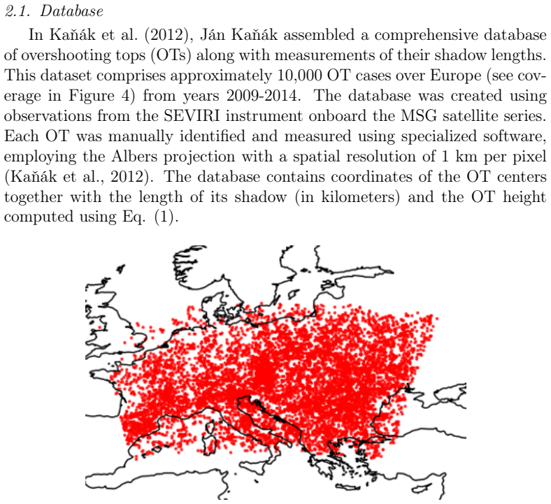
The central claim is that overshooting tops—cloud turrets that punch through the tropopause—can be detected and their heights estimated from visible satellite imagery alone. A convolutional neural network with residual connections, pretrained on ImageNet and fine-tuned on about 10,000 manually annotated European overshooting tops in the SEVIRI high-resolution visible channel, achieves a probability of detection of 0.977 and a false-alarm ratio of 0.036 on a balanced validation set. The regression version of the same network predicts the length of the shadow cast by the overshooting top, and the height follows from the geometric relation $H = S \tan \alpha$, giving a mean height error of 251 m on validation data. The method is deliberately restricted to daylight hours when shadows are visible, but it avoids the brightness-temperature anomalies that can defeat infrared techniques and, unlike those techniques, it yields a quantitative height estimate.
Load-bearing premise
The reported detection accuracy is measured on 150 by 150 kilometer patches centered on known overshooting tops, so the central claim assumes the same performance holds when the model scans full satellite scenes in which overshooting tops are rare.
Editorial extensions
If this is right
- During daylight hours when overshooting tops cast visible shadows, forecasters could run this model on full MSG/SEVIRI scenes to produce probability maps that pinpoint overshooting tops without any infrared input.
- Because the same model outputs a height estimate, it enables quantitative studies of the relation between overshooting-top height and severe weather, such as hail, severe winds, and tornadoes.
- The reported 0.977 probability of detection would surpass earlier deep-learning detectors (about 79 percent) and the best tested infrared threshold method (61 percent), at least for the European daytime distribution on which the model was trained.
- Because the input is uniform 1 km visible imagery, the model can be transferred to polar-orbiting and next-generation geostationary satellites, where finer resolution should shrink the minimum detectable top height from about 2 km toward 1 km.
Reading between the lines
- We infer that a visible-channel-only detector could complement infrared techniques specifically in 'BTD anomaly' cases, where the coldest infrared pixel does not coincide with the visual overshooting top, since the network learns shape and shadow cues rather than temperature patterns.
- A natural extension is to use the SHAP shadow mask as an automated replacement for manual shadow-length annotation, which could cheaply expand training databases to other regions and satellite instruments.
- Testable prediction: applied to Meteosat Third Generation at roughly 0.5 km resolution, the model's minimum detectable overshooting-top height should drop to about 1 km, matching the geometric threshold the paper plots for improved resolution.
Editorial analysis
A structured set of objections, weighed in public.
Referee Report
Summary. The paper trains ResNet18/34 convolutional neural networks on approximately 10,000 manually identified overshooting tops (OTs) over Europe from the SEVIRI high-resolution visible (HRV) channel, together with roughly 120,000 (later ~520,000) non-OT crops, to perform binary OT detection and regress OT shadow length / height. Heights in the database are derived from manual shadow-length measurements via H = S tan(alpha). On centered 150x150-km validation crops a balanced 50/50 model achieves POD 0.977 and FAR 0.036, and the regression model reports a mean height error of 251 m. A sliding-window full-scene probability map is shown only qualitatively. The paper claims operational applicability during daytime shadow conditions and discusses limitations arising from the diurnal cycle, shadow resolution thresholds, and the single-source nature of the ground truth.
Significance. If the full-scene validation gap is closed, this would be a practically useful complement to IR-based OT detection: the visible-only approach is novel among deep-learning OT detectors, the dataset (~10,000 manually labeled OTs over Europe) is one of the largest of its kind, and the joint detection-plus-height estimation is a genuine extension of previous work. The paper includes an honest treatment of class-ratio effects (Figure 9) and a frank limitation statement in Section 4. The main novelty is empirical rather than methodological; the ResNet architecture and transfer-learning setup are standard.
major comments (3)
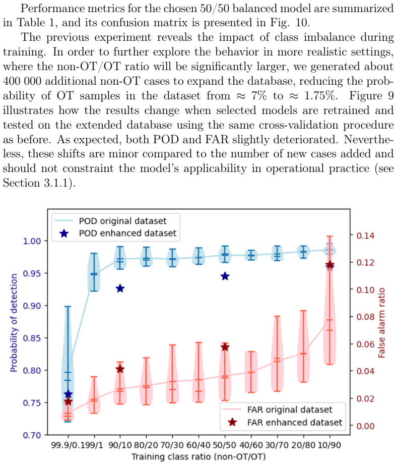
- [Section 3.1.1, Figure 12, Table 1] The headline detection metrics (Table 1) are computed on 150x150 km crops, with every positive sample centered on the OT coordinates (Section 2.1) and every negative sample an OT-free crop (Section 3.1). In operational use the model is applied as a sliding window that assigns the output probability to the central pixel (Section 3.1.1), so an OT will usually appear off-center in the window; because the training set contains no off-center positive examples, the network can exploit a center prior. Consequently the reported POD measures classification of centered OT crops, not detection/localization in full scenes. The only full-scene illustration, Figure 12, is a single qualitative probability map without a quantitative match to the expert-identified OTs or a false-alarm count. A per-window FAR of 0.036 would imply many false alarms per scene (about 1,400 for 40,000 windows at stride 5 in a 1000x1000-km domain), and the extended-dataset experiment in Figure 9 still evaluates isolated patches. The Section 4 caveat that 'the presented scores reflect the model's performance on the validation set' is appropriate but is not reflected in the abstract's unconditional 'detect OTs with a probability of detection reaching 97%.' Please add a full-scene evaluation against expert annotations (object-level precision/recall and false-alarm counts) or explicitly restrict the detection claim to centered-crop classification.
- [Section 3.1 and Table 1; Figure 9] The 50/50 balanced model was selected as 'the most effective configuration' on the basis of the 5-fold cross-validation POD/FAR curves in Figure 9, and the same cross-validation scores are then reported as the headline performance in Table 1. This is selection on the validation set, which makes the reported 0.977 POD and 0.036 FAR optimistic estimates of generalization. Please reserve an independent test split for the final model (or use nested cross-validation) and report the resulting scores, together with the selection procedure.
- [Section 3.2, Table 2, Eq. (1)] The regression target is the manually measured shadow length converted to height via H = S tan(alpha) with an assumed mean cloud-top height of about 10 km (Eq. 1). The 251 m mean height error in Table 2 is thus an agreement score with the human shadow measurements that define the ground truth, not an independent validation of OT height. No external benchmark (e.g., CloudSat, radar, stereo imagery, or NWP) is used. The abstract's 'average error of 0.25 km' should be qualified as an error with respect to manual shadow-length-based measurements, or an independent height validation should be added; otherwise the height-accuracy claim is overstated.
minor comments (5)
- [Section 2.2] The text describes an 80/20 training/test split but then reports 5-fold cross-validation; clarify whether the test set is a separate held-out portion or part of the cross-validation folds.
- [Sections 2.1 and 3.1.1] There are several typos: 'desreasing' should be 'decreasing', 'simultaneusly' should be 'simultaneously', and 'OT top detection' should be 'OT detection'.
- [Section 3.1] The assertion that many non-OT cases are easy to classify is central to the class-ratio argument; please support it with quantitative evidence, such as a distribution of model confidence on hard and easy negatives.
- [Section 3.2 / Table 2] Please report the number of validation samples and the cross-validation spread for the regression metrics; only point estimates are currently given.
- [Reproducibility] Please state whether the trained models, code, and (if possible) the de-identified database or sample indices will be made available.
Circularity Check
No significant circularity: the detection and height-estimation claims are supervised empirical evaluations on held-out data, not derivations that reduce to their own inputs.
full rationale
The paper's central claims are empirical supervised-learning results, not first-principles derivations. The OT height target is defined by the independent geometric relation H = S·tan(alpha) (Eq. 1), with shadow length S measured manually by human experts in the Kanak et al. (2012) database. The CNN is then trained to regress S from HRV patches and is evaluated on held-out validation folds from the same database. This is standard supervised evaluation: the validation targets are not derived from the model's outputs, and the model does not fit the validation samples. The detection POD/FAR likewise come from cross-validation on a fixed labeled dataset; the labels are human judgments, and the model is not designed to reproduce those labels by construction. The only self-referential aspect is provenance: the ground-truth database was assembled by co-author Kanak, and the paper explicitly acknowledges this in Section 4: 'The presented scores reflect the model’s performance on the validation set, which is based on the implicit definition of what constitutes an OT, determined during the assembly of the training database in (Kaňák et al., 2012) by its authors, and on the procedure for generating the non-OT portion of the database described in Section 3.1.' That is a data-provenance limitation, not a logical circularity: the database is an external empirical artifact with stated measurement procedures, and the model's predictions are compared against held-out measurements rather than being hard-wired to them. Concerns about transfer from centered-patch validation to full-scene scanning (Section 3.1.1, Figure 12) are about external validity and operational generalization, not about equivalence of inputs and outputs. Accordingly, no step in the paper reduces, by its own equations or by self-citation, to its own inputs.
Assumptions & free parameters
free parameters (7)
- CNN weights (ResNet18/34) =
Learned during training
- training class ratio non-OT/OT =
50/50 for the final balanced model
- learning rate =
0.001 for classification, 0.01 for regression
- number of epochs =
10
- dropout rate =
0.5
- input patch size =
150 x 150 km
- stride for scene probability map =
5 pixels
assumptions (6)
- standard math OT height H and shadow length S follow H = S tan alpha, where alpha is the sun elevation angle.
- domain assumption The difference between the sun elevation angle at the Earth's surface and at 10 km cloud-top height is negligible, so the surface sun angle can be used directly.
- domain assumption Manual OT labels and shadow-length measurements in the Kanak et al. (2012) database are correct and define the ground truth.
- domain assumption Non-OT training patches are truly OT-free and representative of the full satellite scenes where the model will be applied.
- domain assumption ImageNet-pretrained ResNet features transfer usefully to HRV cloud-top imagery.
- domain assumption The 5-fold cross-validation splits are temporally or otherwise independent and yield unbiased estimates of generalization.
Cite this review
Pith. "Pith review of Automatic detection of overshooting tops and their properties from visible satellite channels." pith.science (2026). https://pith.science/paper/HCZF3HJ3
@misc{pith2026250600246,
  author       = {Pith},
  title        = {Pith review of: Automatic detection of overshooting tops and their properties from visible satellite channels},
  year         = {2026},
  howpublished = {\url{https://pith.science/paper/HCZF3HJ3}},
  note         = {Machine review of arXiv:2506.00246}
}
read the original abstract
Overshooting tops (OTs) are informative indicators of convective storm intensity and are widely utilized in meteorological analyses. This study presents an automated algorithm for OT detection and OT height estimation using convolutional neural networks applied to visible satellite imagery. The models are trained and validated on an extensive OT dataset comprising approximately 10,000 manually detected cases over Europe. The OTs were identified from high-resolution visible (HRV) channel of the SEVIRI instrument on board the MSG geostationary satellite, with the heights determined from the length of their shadows in the imagery. While conventional OT detection methods primarily rely on the identification of cold features in thermal infrared channels, our approach extracts information from visible channels, leveraging the ground truth data on OT shadow length provided by the training dataset. In the morning and afternoon hours, when the shadows are visible, the proposed models detect OTs with a probability of detection reaching 97% and estimate their height with an average error of 0.25 km. The performance is expected to further improve once the model is applied to polar and new generation geostationary satellites with increased spatial resolution.
Figures


Figures from the paper (12 more)




Reference graph
Works this paper leans on
-
[1]
author Bedka, K. , author Brunner, J. , author Dworak, R. , author Feltz, W. , author Otkin, J. , author T., G. , year 2010 . title Objective satellite-based detection of overshooting tops using infrared window channel brightness temperature gradients . journal Journal of Applied Meteorology and Climatology , pages 181--202 https://doi.org/10.1175/2009JAMC2286.1
-
[2]
author Bedka, K.M. , author Dworak, R. , author Brunner, J. , author Feltz, W. , year 2012 . title Validation of satellite-based objective overshooting cloud-top detection methods using cloudsat cloud profiling radar observations. journal Journal of Applied Meteorology and Climatology , pages 1811--1822 https://doi.org/10.1175/JAMC-D-11-0131.1
-
[3]
author Bluestein, H.B. , author Lindsey, D.T. , author Bikos, D. , author Reif, D.W. , author Wienhoff, Z.B. , year 2019 . title The relationship between overshooting tops in a tornadic supercell and its radar-observed evolution . journal Monthly Weather Review volume 147 , pages 4151 -- 4176 . https://journals.ametsoc.org/view/journals/mwre/147/11/mwr-d-...
-
[4]
author Deng, J. , author Dong, W. , author Socher, R. , author Li, L.J. , author Li, K. , author Fei-Fei, L. , year 2009 . title Imagenet: A large-scale hierarchical image database , in: booktitle 2009 IEEE Conference on Computer Vision and Pattern Recognition , pp. pages 248--255 . :10.1109/CVPR.2009.5206848
arXiv 2009
-
[5]
author Dworak, R. , author Bedka, K. , author Brunner, J. , author Feltz, W. , year 2012 . title Comparison between GOES-12 Overshooting-Top Detections, WSR-88D Radar Reflectivity, and Severe Storm Reports . journal Weather and Forecasting volume 27 . :10.1175/WAF-D-11-00070.1
-
[6]
author He, K. , author Zhang, X. , author Ren, S. , author Sun, J. , year 2016 . title Deep residual learning for image recognition . journal In Proceedings of the IEEE conference on computer vision and pattern recognition , pages 770--778
work page 2016
-
[7]
author Howard, J. , author Gugger, S. , year 2021 . title Deep learning for coders with FASTAI and pytorch: AI applications without a Phd . publisher O’Reilly Media
work page 2021
-
[8]
author Kanneganti, G.T. , year 2020 . title Detection of Overshooting Cloud Tops with Convolutional Neural Networks . type Master's thesis . University of Oklahoma. note Available at https://hdl.handle.net/11244/324409
work page 2020
Show all 24 references
-
[9]
, author Bedka, K.M
author Kaňák, J. , author Bedka, K.M. , author A., S. , year 2012 . title Mature convective storms and their overshooting tops over central europe: Overshooting top height analysis for summers 2009-2011 . journal Conference: 2012 EUMETSAT Meteorological Satellite Conference, S...
2012
-
[10]
, author Lee, J
author Kim, M. , author Lee, J. , author Im, J. , year 2018 . title Deep learning-based monitoring of overshooting cloud tops from geostationary satellite data . journal GIScience & Remote Sensing volume 55 , pages 763--792 . https://doi.org/10.1080/15481603.2018.1457201, :10....
2018
-
[11]
, author Ba, J
author Kingma, D.P. , author Ba, J. , year 2017 . title Adam: A method for stochastic optimization . https://arxiv.org/abs/1412.6980, http://arxiv.org/abs/1412.6980 arXiv:1412.6980
2017 arXiv
-
[12]
, author Lee, S.I
author Lundberg, S.M. , author Lee, S.I. , year 2017 . title A unified approach to interpreting model predictions , in: booktitle Advances in Neural Information Processing Systems , publisher Curran Associates, Inc
2017
-
[13]
, author Strelec Mahović, N
author Mikuš, P. , author Strelec Mahović, N. , year 2013 . title Satellite-based overshooting top detection methods and an analysis of correlated weather conditions . journal Atmospheric Research volume 123 , pages 268--280 . https://www.sciencedirect.com/science/article/pii/...
2013 doi
-
[14]
, author Matczak, P
author Piasecki, K. , author Matczak, P. , author Taszarek, M. , author Czernecki, B. , author Skop, F. , author Sobisiak, A. , year 2023 . title Giant hail in poland produced by a supercell merger in extreme instability – a sign of a warming climate? journal Atmospheric Resea...
2023
-
[15]
, year 2015
author Radová, M. , year 2015 . title Cloud-top morphology of convective storms as observed by meteorological satellites . note Available at http://hdl.handle.net/20.500.11956/76186
2015
-
[16]
, author Rotunno, R
author Ricchi, A. , author Rotunno, R. , author Miglietta, M.M. , author Picciotti, E. , author Montopoli, M. , author Marzano, F. , author Baldini, L. , author Vulpiani, G. , author Tiesi, A. , author Ferretti, R. , year 2023 . title Analysis of the development mechanisms of ...
2023
-
[17]
, author Pili, P
author Schmetz, J. , author Pili, P. , author Tjemkes, S. , author Just, D. , author Kerkmann, J. , author Rota, S. , author Ratier, A. , year 2002 . title An introduction to meteosat second generation (msg) . journal Bull. Amer. Meteor. Soc. volume 83 , pages 977--992 . https...
2002 doi
-
[18]
, author Lindsey, D.T
author Setvák, M. , author Lindsey, D.T. , author Novák, P. , author Wang, P.K. , year 2010 . title Satellite-observed cold-ring-shaped features atop deep convective clouds . journal Atmospheric Research , pages 80--96 https://doi.org/10.1016/j.atmosres.2010.03.009
2010 doi
-
[19]
, author Rabin, R.M
author Setvák, M. , author Rabin, R.M. , author Wang, P.K. , year 2007 . title Contribution of the modis instrument to observations of deep convective storms and stratospheric moisture detection in goes and msg imagery. journal Atmospheric Research , pages 505--518 10.1016/j.a...
2007 doi
-
[20]
, author Khoshgoftaar, T.M
author Shorten, C. , author Khoshgoftaar, T.M. , year 2019 . title A survey on image data augmentation for deep learning . journal Journal of Big Data volume 6 , pages 2196--1115 . https://doi.org/10.1186/s40537-019-0197-0, :10.1186/s40537-019-0197-0
2019 doi
-
[21]
, author Lu, G
author Sun, N. , author Lu, G. , author Fu, Y. , year 2024 . title Microphysical characteristics of precipitation within convective overshooting over east china observed by GPM DPR and ERA5 . journal Atmospheric Chemistry and Physics volume 24 , pages 7123--7135 . https://acp....
2024 doi
-
[22]
, author Khoshgoftaar, Taghi M
author Weiss, K. , author Khoshgoftaar, Taghi M. andWang, D. , year 2016 . title A survey of transfer learning . journal Journal of Big Data volume 3 , pages 2196--1115 . https://doi.org/10.1186/s40537-016-0043-6, :10.1186/s40537-016-0043-6
2016 doi
-
[23]
, author Korzets, M
author Yair, Y. , author Korzets, M. , author Devir, A. , author Korman, M. , author Stibbe, E. , year 2024 . title Space-based optical imaging of blue corona discharges on a cumulonimbus cloud top . journal Atmospheric Research volume 305 , pages 107445 . https://www.scienced...
2024
-
[24]
, author Xiao, W
author Yang, S. , author Xiao, W. , author Zhang, M. , author Guo, S. , author Zhao, J. , author Shen, F. , year 2023 . title Image data augmentation for deep learning: A survey . https://arxiv.org/abs/2204.08610, http://arxiv.org/abs/2204.08610 arXiv:2204.08610
2023 arXiv
Reviewed August 7, 2026 · model on record in the stance chip above.
Discussion (0). Sign in to comment.