REVIEW 4 major objections 5 minor 22 references
Algorithmic Analysis of GTFS-RT vehicle position accuracy
T0 review · 4 major / 5 minor · reviewed 2026-08-07 · deepseek-v4-flash
Pith's one-line read This paper claims that three newly assembled geodesic algorithms can compute the shortest distance from a GPS point to a scheduled transit route on the WGS84 ellipsoid, and that applying them to California's GTFS-RT feeds exposes…
desk verdict A large real-world dataset and an honest Discussion can't carry a paper whose core distance algorithm is unproven and whose central novelty claim is unsupported. read the letter →
The pith
A machine-rendered reading of the paper's core claim, the machinery that carries it, and where it could break.
The reading
What carries the argument
The load-bearing object is the geodesic intersection on the WGS84 ellipsoid: the closest point on a scheduled-route segment to a vehicle position is characterized by the connecting geodesic meeting the segment at right angles, and the routine iterates between inverse and direct geodesic calculations until that perpendicular condition holds. The faster convergence comes from two update equations that replace the initial guess, and the point-to-linestring layer uses a k-d tree, a spatial index that returns the nearest stored shape point in logarithmic time, so each query tests only the two segments adjacent to that point plus the point itself. That reduction from checking every segment is what makes statewide-scale analysis feasible, and it is also the part whose correctness guarantee is left open.
What would settle it
Build a synthetic route shape shaped like a sinusoidal wiggle around a great circle, place a query point near the pole of that great circle, and compare the algorithm's reported distance with the brute-force minimum over all route segments; if the k-d-tree result is larger, the shortest-distance guarantee fails.
Extended reading notes
Core claim
The central claim is that the minimum distance from a real-time vehicle position to a scheduled route can be computed directly on the WGS84 ellipsoid, without planar projection, by combining three pieces: a corrected iterative geodesic-intersection routine that handles arbitrary points and geodesic segments, a faster update formula for that routine, and a point-to-linestring wrapper that uses a k-d tree to find the nearest route-shape point and then solves the point-to-segment problem on the two neighboring segments. The paper further claims that applying this machinery to California's GTFS-RT feeds produces a usable accuracy measurement: of roughly 460 million position data points, about 314 million intersections were computed, and the results show both correctable anomalies and persistent large-scale discrepancies, including a nightly drop in the percentage of vehicles within 35 meters of their route. The author states that these are three new algorithms and frames the work as a method for assessing vehicle position drift.
Load-bearing premise
The whole distance calculation rests on assuming that the closest point on a route to a vehicle always lies on one of the two route segments adjacent to whichever shape point the k-d tree finds nearest; the paper states in Section 6 that this guarantee is not proven, and describes a wavy route where many points would be equidistant.
Editorial extensions
If this is right
- If the algorithms hold up, any transit agency can compute per-vehicle distance-from-route in logarithmic time per position, making real-time GPS drift monitoring practical.
- The reported data-quality numbers, roughly 30 percent of positions unmatchable to a trip or shape, give feed producers a concrete list of fields to fix, starting with unlinking vehicles from trips after service ends.
- The point-to-geodesic-segment routine generalizes beyond transit to any problem that needs the shortest distance from a GPS point to a mapped path on the Earth's ellipsoid.
- Because shapes are indexed once and queried many times, the same approach can be reused for daily or weekly accuracy audits of an entire state's transit feeds.
Reading between the lines
- Section 6 concedes that the k-d tree step is not proven to guarantee the true shortest distance; a route with a sinusoidal offset and a query point near the great-circle pole would create many equidistant shape points, so the two-segment test could miss the true closest segment.
- A natural stress test would compare the algorithm's answer against a brute-force scan of every segment on synthetic wavy shapes; if they disagree, restricting the candidate set to k nearest neighbors instead of one would likely restore correctness.
- The same distance metric could be turned into a data-quality flag for GTFS static feeds, catching the 'stop too far from shape' class of errors that the paper cites as a possible cause of its high standard deviation.
Editorial analysis
A structured set of objections, weighed in public.
Referee Report
Summary. The paper presents three algorithms for geodesic calculations on the WGS84 ellipsoid: computation of an ellipsoidal triangle's internal angles (Algorithm 2), a geodesic intersection routine built on Baselga and Martinez-Llario and Karney (Algorithm 3), and a point-to-linestring distance algorithm using a k-d tree (Algorithm 4). These are applied to a week of California GTFS-RT vehicle positions to estimate how far vehicles are from their scheduled routes, yielding nightly patterns and per-agency standard deviations, plus maps of positional errors. The paper also proposes practical fixes for data producers and consumers and discusses limitations, including an unproven guarantee for the k-d tree heuristic.
Significance. If the algorithms are correct, the point-to-linestring routine would offer a computationally attractive alternative to brute-force geodesic distance computation, and the large-scale Cal-ITP dataset (460 million data points) would give a useful picture of real-time transit position quality. The manuscript is honest about open issues, and the use of Karney's established algorithms is a sound foundation. The explicit acknowledgment of the unproven k-d tree property and the sinusoidal counterexample in the Discussion is commendable, but that acknowledgment does not replace the missing proof or validation. The empirical conclusions are not anchored to independent ground truth, so the central algorithmic and empirical claims both need substantial strengthening before the paper can be accepted.
major comments (4)
- [Section 4.2, Algorithm 4] The point-linestring algorithm's correctness depends on the assumption that the closest point on the linestring lies on one of the two geodesic segments adjacent to the k-d tree nearest shape point. The paper itself concedes in Section 6 that this is not proven and sketches a sinusoidal-offset linestring with many equidistant points. Because every distance measurement in Section 5 is produced by this algorithm, a failure of the heuristic would make the nightly pattern, per-agency standard deviations, and error maps artifacts of the search heuristic rather than real positional drift. The manuscript needs either a proof of the adjacency property or a validation against brute-force computation on a substantial subsample, with quantitative agreement reported before the case-study results can be accepted.
- [Algorithm 3, line 15] The update formula in Algorithm 3 uses the undefined variable 'map', and Eq. (2) in Section 3.2 uses the same placeholder. Without a definition, the Karney-improved step cannot be implemented or evaluated. This is a central part of the point-segment routine, not a cosmetic typo, and should be fixed or the line should be replaced with the explicit expression.
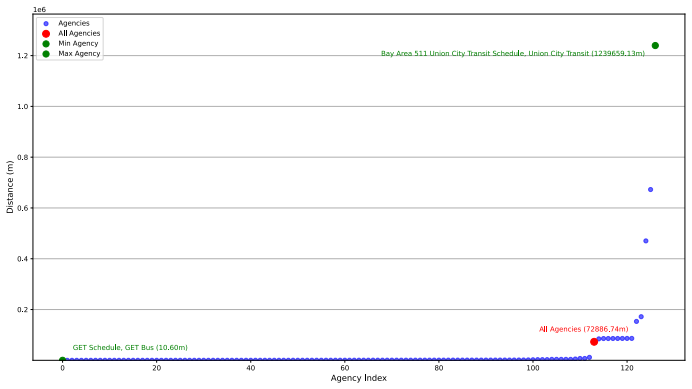
- [Section 5, Figures 1-3] The empirical results report percentages and standard deviations without confidence intervals, error bars, or ground-truth validation. The '35-meter threshold' is justified only by a qualitative statement about road width, with no sensitivity analysis. The only external comparison is anecdotal (Section 5.2: 'some routes in GTFS were 10-30 meters away from a road/pathway'), so the headline accuracy figures are not anchored to an independent reference. At minimum, the analysis should include a sensitivity sweep over the threshold and a comparison against a map-matched or surveyed reference for a subset of vehicles.
- [Section 4.1 and Section 6] The paper states that the internal-angle calculation 'currently only works for small ellipsoidal triangles as it assumes the maximum sum of internal angles of the ellipsoidal triangle is 180°', and no proof is given. Since Algorithm 3 depends on these angles, the scope of validity of the whole stack is unclear. The text should either supply the proof or explicitly characterize the maximum triangle size for which the approximation is valid, and verify that the case-study data lie within that range.
minor comments (5)
- [Section 2] In the description of Vehicle Positions, the sentence 'This feed sometimes contains the This feed can be updated with new trips or removed trips if necessary' is a grammatical error and should be rewritten.
- [Section 3.1] The name 'Stenier' appears in the text; it should be 'Steiner' to match the reference list.
- [Section 5.1] The phrase 'the unusually high standard deviation 3 found in the dataset' is unclear: the superscript 3 appears to be an artifact and the intended quantity should be stated explicitly.
- [Section 4.2] The problem statement says the goal is to 'find the closest point in that set to that random point', but the algorithm actually computes the minimum distance from the point to the linestring, including points interior to segments. The wording should match the implemented problem.
- [References] Reference [13] appears to be a thesis or report without a clear publisher or year; please provide complete citation details.
Circularity Check
No circularity: the analysis transforms GTFS-RT positions and GTFS shapes into distances using cited external geodesic routines; no result reduces to its inputs by construction.
full rationale
The paper contains no circular derivation. The geodesic intersection machinery (Algorithms 2 and 3) is explicitly built on external, cited work by Baselga and Martinez-Llario [6] and Karney [11, 12], and Algorithm 4 is a k-d tree nearest-neighbor search combined with calls to that external machinery. The empirical claims in Section 5 are direct measurements: GTFS-RT vehicle positions are matched to GTFS route shapes and distances are computed, with no fitted parameter renamed as a prediction and no quantity defined in terms of the conclusion it is supposed to support. The main weakness, acknowledged by the paper itself in Section 6, is that the k-d tree heuristic is not proven to guarantee the shortest point-to-linestring distance; its failure could invalidate the measured distances, but this is an unproven correctness assumption rather than a circular step. There are no load-bearing self-citations, no uniqueness theorem imported from the authors' prior work, and no ansatz smuggled in via citation. The claim that the algorithms are 'novel' may be an originality concern, but originality is not circularity. Accordingly, no specific circular step can be quoted and exhibited, and the appropriate score is 0.
Assumptions & free parameters
free parameters (1)
- 35-meter threshold =
35 m
assumptions (4)
- standard math Karney's direct and inverse geodesic algorithms are accurate and converge
- domain assumption The internal angles of a small ellipsoidal triangle sum to 180 degrees
- ad hoc to paper The nearest neighbor in a k-d tree plus its two neighbors always contain the closest point on a linestring
- domain assumption GTFS shape data and OpenStreetMap data are accurate enough to serve as reference
Cite this review
Pith. "Pith review of Algorithmic Analysis of GTFS-RT vehicle position accuracy." pith.science (2026). https://pith.science/paper/VW5W45KK
@misc{pith2026250606479,
  author       = {Pith},
  title        = {Pith review of: Algorithmic Analysis of GTFS-RT vehicle position accuracy},
  year         = {2026},
  howpublished = {\url{https://pith.science/paper/VW5W45KK}},
  note         = {Machine review of arXiv:2506.06479}
}
read the original abstract
This paper presents three novel algorithms for calculating geodesic intersections on an ellipsoid. These algorithms are applied in a case study analyzing real-time transit data in California to assess vehicle position drift. The analysis reveals that while certain data anomalies can be corrected, large-scale discrepancies persist. The paper concludes by proposing a set of practical solutions that can be implemented by either data producers or consumers to significantly improve positional accuracy.
Figures


Figures from the paper (2 more)


Reference graph
Works this paper leans on
-
[1]
11 - solving the geodetic triangles on the reference ellipsoid. In V.C. DRAGOMIR, D.N. GHIT ˘AU, M.S. MIH ˘AILESCU, and M.G. ROTARU, editors,Theory of the Earth’s Shape, volume 13 ofDevelopments in Solid Earth Geophysics, pages 224–232. Elsevier, 1982
work page 1982
-
[2]
Zack Aemmer, Andisheh Ranjbari, and Don MacKenzie. Measurement and classification of transit delays using gtfs-rt data.Public Transport, 14(2):263–285, 2022
work page 2022
-
[3]
J. P. Ballantine and A. R. Jerbert. Distance from a line, or plane, to a poin.The American Mathematical Monthly, 59(4):242–243, 1952
work page 1952
-
[4]
Overcoming barriers for the wide-scale adoption of standardized real-time transit information
Sean J Barbeau et al. Overcoming barriers for the wide-scale adoption of standardized real-time transit information. Technical report, National Institute for Transportation and Communities (NITC), 2018
work page 2018
-
[5]
Enabling cost-effective multimodal trip plan- ners through open transit data
SJ Barbeau and EL Hillsman. Enabling cost-effective multimodal trip plan- ners through open transit data. Technical report, Technical report, Uni- versity of South Florida (USF) National Center for . . . , 2011
work page 2011
-
[6]
Sergio Baselga and Jos´ e Carlos Mart ´ ınez-Llario. Intersection and point-to- line solutions for geodesics on the ellipsoid.Studia Geophysica et Geodaet- ica, 62(3):353–363, 7 2018. 11
work page 2018
-
[7]
Filip Biljecki, Yoong Shin Chow, and Kay Lee. Quality of crowdsourced geospatial building information: A global assessment of openstreetmap at- tributes.Building and Environment, 237:110295, 2023
work page 2023
-
[8]
California Open Data Portal. GTFS Datasets.https://data.ca. gov/dataset/de6f1544-b162-4d16-997b-c183912c8e62/resource/ e4ca5bd4-e9ce-40aa-a58a-3a6d78b042bd/download/gtfs_datasets. csv, 2024. Accessed: 2024-12-10
work page 2024
Show all 22 references
-
[9]
A survey of errors in gtfs static feeds from the united states.Findings, 2024
Saipraneeth Devunuri and Lewis Lehe. A survey of errors in gtfs static feeds from the united states.Findings, 2024
2024
-
[10]
The difference between the wgs84 and the etrs89 coordinate reference systems.UNIVER- SITAS PUBLISHING HOUSE Petro¸ sani–ROMˆANIA, 2013, 14:119–122, 2013
KLAUS GERHART FISSGUS and RARES ¸ MUNTEANU. The difference between the wgs84 and the etrs89 coordinate reference systems.UNIVER- SITAS PUBLISHING HOUSE Petro¸ sani–ROMˆANIA, 2013, 14:119–122, 2013
2013
-
[11]
Charles F. F. Karney. Algorithms for geodesics.Journal of Geodesy, 87(1):43–55, June 2012
2012
-
[12]
Charles F. F. Karney. Geodesic intersections, 2023
2023
-
[13]
Pondiˆ onstracker: A framework based on gtfs-rt to identify delays and estimate arrivals dynamically in public transportation network
Pedro Pongelupe Lopes. Pondiˆ onstracker: A framework based on gtfs-rt to identify delays and estimate arrivals dynamically in public transportation network
-
[14]
General transit feed specification (gtfs) realtime reference,
MobilityData. General transit feed specification (gtfs) realtime reference,
-
[15]
General transit feed specification (gtfs) schedule reference,
MobilityData. General transit feed specification (gtfs) schedule reference,
-
[16]
Long geodesics on the ellipsoid.Bulletin G´ eod´ esique (1946-1975), 37:12–22, 1955
Hume F Rainsford. Long geodesics on the ellipsoid.Bulletin G´ eod´ esique (1946-1975), 37:12–22, 1955
1946
-
[17]
Accessed: 2024-08-05
2024
-
[18]
Khoa Tran, Sean Barbeau, Edward Hillsman, and Miguel A Labrador. Go sync—a framework to synchronize crowd-sourced mapping contributors from online communities and transit agency bus stop inventories.Inter- national Journal of Intelligent Transportation Systems Research, 11:54–64, 2013
2013
-
[19]
Quality assess- ment of open realtime data for public transportation in the netherlands
Daniel Steiner, Hartwig Hochmair, and Gernot Paulus. Quality assess- ment of open realtime data for public transportation in the netherlands. GI Forum J. Geogr. Inf. Sci, 2015:579–588, 2015
2015
-
[20]
Accessibility beyond the schedule, May 2019
Nate Wessel. Accessibility beyond the schedule, May 2019
2019
-
[21]
Direct and inverse solutions of geodesics on the ellip- soid with application of nested equations.Survey review, 23(176):88–93, 1975
Thaddeus Vincenty. Direct and inverse solutions of geodesics on the ellip- soid with application of nested equations.Survey review, 23(176):88–93, 1975
1975
-
[23]
Constructing a routable retro- spective transit timetable from a real-time vehicle location feed and gtfs
Nate Wessel, Jeff Allen, and Steven Farber. Constructing a routable retro- spective transit timetable from a real-time vehicle location feed and gtfs. Journal of Transport Geography, 62:92–97, 2017. 12
2017
Reviewed August 7, 2026 · model on record in the stance chip above.
Discussion (0). Sign in to comment.