REVIEW 3 major objections 5 minor 25 references
A Versatile and Programmable UAV Platform for Radio Access Network and End-to-End Cellular Measurements
T0 review · 3 major / 5 minor · reviewed 2026-08-05 · deepseek-v4-flash
Pith's one-line read A drone-borne LTE probe shows rural signal strength rising with altitude while signal quality falls.
desk verdict A genuinely useful UAV cellular measurement platform that reproduces a known altitude-quality tradeoff; the causal story (LoS gain, neighbor interference) is asserted rather than tested, and the open-source artifacts are missing. read the letter →
The pith
A machine-rendered reading of the paper's core claim, the machinery that carries it, and where it could break.
The reading
What carries the argument
The platform's core is an integrated UAV system: an NVIDIA Jetson Orin onboard computer running ROS, a flight controller supplying GPS/IMU/pressure data, and a Microhard pMLTE commercial LTE modem. Custom logging software, deployed on the Orin, queries the modem over Ethernet at one-second intervals to record RSRP, RSRQ, RSSI, SINR, PCI, Cell ID, LAC, and neighbor-cell measurements, while Nping and iPerf3 provide RTT and bidirectional throughput to a dedicated server. Geospatial 2D/3D maps and statistical CDF/PDF analyses turn these logs into altitude-resolved coverage and quality assessments.
What would settle it
Fly the same platform at constant horizontal distance from a known base station and vary only altitude, while logging serving and neighbor cell RSRP, RSRQ, and SINR; if RSRP no longer rises with altitude or the RSRQ/SINR drop disappears once neighbor-cell received power is accounted for, the paper's altitude-tradeoff explanation is not supported.
Extended reading notes
Core claim
The central claim is that a UAV equipped with a commercial LTE modem and a custom onboard logger can simultaneously capture Radio Access Network metrics (RSRP, RSRQ, RSSI, SINR, cell IDs, neighbor-cell data) and end-to-end performance metrics (RTT, uplink and downlink throughput) in rural terrain. The experiments show an altitude-dependent tradeoff: higher altitude improves received signal power due to enhanced line-of-sight conditions, while degrading signal quality because of increased interference from neighboring cells. The paper further concludes that, in the area tested, the network delivered acceptable signal quality over roughly 85% of the region, throughput above 5 Mbps in both dire
Load-bearing premise
The altitude-dependent RSRP gain is attributed to improved line-of-sight, but distance to the serving base station was not held constant across altitudes, so the gain could partly or wholly be a distance effect.
Editorial extensions
If this is right
- Rural carriers can use this platform to build three-dimensional coverage maps without road access, addressing terrain and sparse-population gaps in crowd-sourced data.
- The measured altitude tradeoff implies that aerial users may need different cell-selection or handover rules than ground users, since stronger signal power can coincide with worse signal quality.
- The open-source logger offers a lower-cost, customizable alternative to licensed commercial testing tools and to SDR systems that capture only basic signal strength.
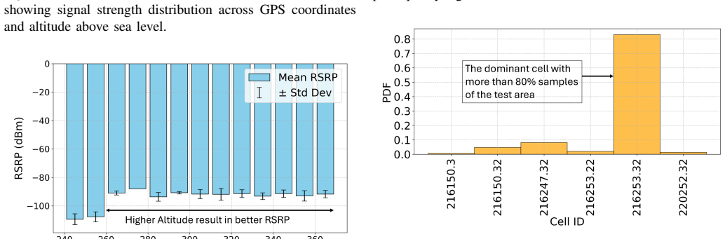
- Coverage planning should weigh both signal-strength metrics and the spatial extent over which a cell actually serves the area, not just per-cell RSRP averages.
- The framework can quantify both radio-layer coverage and application-level experience (throughput, latency) in one flight, supporting more complete rural network assessment.
Reading between the lines
- If the altitude-driven RSRP gain holds after controlling for distance to the serving cell, it would strengthen the case for designing UAV-specific interference mitigation, such as directional antennas or altitude-aware frequency planning, for aerial connectivity.
- The same measurement method could be extended to predict ground-level coverage in inaccessible rural areas from aerial samples, though the paper only lists that as future work.
- The neighbor-cell logs suggest handover prospects are generally good at altitude because at least one neighbor cell remains strong, but whether that holds in more obstructed or denser environments remains an open question the paper does not test.
- The reported throughput and RTT numbers are a snapshot from one rural site; repeating the flights across seasons and different terrain would clarify how vegetation and topography shift the altitude tradeoff.
Editorial analysis
A structured set of objections, weighed in public.
Referee Report
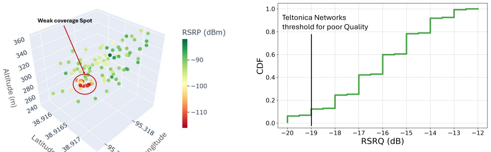
Summary. The paper presents a UAV-mounted cellular measurement platform combining a Jetson Orin, a Microhard pMLTE commercial modem, and custom data-logging software to collect RAN metrics (RSRP, RSRQ, RSSI, SINR) and end-to-end metrics (throughput, RTT) in a rural test site near Clinton Lake, Kansas. Experimental results show that RSRP improves with altitude, while RSRQ and SINR degrade; the authors attribute this to improved line-of-sight to the serving cell and increased neighboring-cell interference at altitude. They report that about 85% of the area has acceptable RSRQ, more than 90% of measurements exceed 5 Mbps in both directions, and more than 80% of RTT samples are below 150 ms.
Significance. If the platform and findings are validated, this is a useful open-source contribution: it addresses a real gap in rural cellular measurement, combines radio-layer and application-layer data at 1 s resolution, and avoids proprietary drive-test tools. The paper explicitly offers reproducibility advantages over commercial solutions and prior SDR-based approaches. The altitude-dependent tradeoff and the observation that strong cell-level signal metrics do not guarantee spatial coverage are potentially interesting for UAV communications and network planning. However, the central physical interpretation is currently under-supported, so the significance is conditional on additional analysis.
major comments (3)
- [Section III-A, Fig. 4] The claim that RSRP improves with altitude 'primarily' due to enhanced LoS is not established because the experiment does not control for distance to the serving cell or terrain. If the UAV is closer to the cell or over open ground at higher altitudes, the RSRP gain could be a propagation-distance effect rather than LoS. The authors should stratify RSRP by horizontal distance to the serving cell (or include path-loss analysis and terrain profile) before attributing the trend to LoS.
- [Section III-A, Fig. 8] The degradation of RSRQ/SINR with altitude is attributed to increased neighboring-cell interference, but no altitude-resolved neighbor-cell RSSI or interference measurement is presented. Fig. 8 shows only aggregate neighbor statistics across the whole flight. The authors should show that neighbor-cell received power increases with altitude and that RSRQ/SINR degrades when neighbor RSSI is higher, or explicitly soften the causal claim.
- [Section III-A/III-B] No statistical detail is provided for the altitude trends: number of samples per altitude bin, variance, or confidence intervals are missing. Since Fig. 4 is the key evidence for the tradeoff, the authors should report sample sizes and dispersion so readers can judge whether the trend is robust.
minor comments (5)
- [Title and throughout] 'UA V' appears with spurious spaces repeatedly; should be 'UAV'.
- [Section III-B, Fig. 5] The threshold is attributed to 'Teltonica Networks'; the correct spelling is Teltonika. Also, the CDF is over measurement samples, not strictly 'area'; please rephrase as '15% of measurement locations' or provide an area-weighted analysis.
- [Section III-C] The text says 'more than 90% of the coverage region supports throughput...' but the CDF is over samples/locations. Rephrase to avoid implying spatial interpolation.
- [Section II-A and II-B] The paper would benefit from a table listing all collected metrics and their units, and from stating the number of flights, flight duration, and weather conditions to support reproducibility.
- [Section III-A, Fig. 3] The caption says 'altitude above sea level' but the text discusses altitude in terms of flight altitude above ground; clarify which reference is used.
Circularity Check
No circularity: the paper reports an empirical measurement platform and observational results; no fitted parameters are relabeled as predictions and no load-bearing claim reduces to its own inputs.
full rationale
The paper is an instrumentation-and-measurement study. Its central claims are that the UAV platform can collect RAN and end-to-end metrics simultaneously and that field data show an altitude-dependent tradeoff (RSRP improving with altitude, RSRQ/SINR degrading). There is no derivation chain, no fitting procedure, and no predictive model. The altitude-tradeoff statement is presented as an interpretation of plotted measurements (Section III-A, Figures 3-4), not as a quantity derived from equations. The RSRQ poor-quality threshold of -19 dB is taken from an external source, Teltonika Networks [24], and is not fitted to the data. No parameter is fit to one subset and then used to 'predict' a closely related quantity. The self-citations that appear ([5], [6]) concern spectrum sensing and UTM systems and are not load-bearing for the cellular measurement claims. The only potential concern is that the interpretation attributes RSRP gains to improved line-of-sight and RSRQ/SINR loss to neighboring-cell interference without controlling for distance to the serving cell; however, that is an empirical-identification/correctness issue about causal attribution, not circularity. Under the definition used here, circularity requires a prediction or derivation that is equivalent by construction to its inputs, and no such step exists in the paper.
Assumptions & free parameters
free parameters (1)
- RSRQ poor-quality threshold =
-19 dB
assumptions (3)
- domain assumption The pMLTE modem's reported RSRP, RSRQ, RSSI, and SINR accurately represent the radio environment at the UAV's position.
- domain assumption The altitude-dependent RSRP improvement is attributable to enhanced line-of-sight rather than changing distance to the serving cell.
- domain assumption The area-based coverage statistics (e.g., 85% acceptable) are generalizable from the specific flight path.
Cite this review
Pith. "Pith review of A Versatile and Programmable UAV Platform for Radio Access Network and End-to-End Cellular Measurements." pith.science (2026). https://pith.science/paper/WGLMPAIP
@misc{pith2026250903818,
  author       = {Pith},
  title        = {Pith review of: A Versatile and Programmable UAV Platform for Radio Access Network and End-to-End Cellular Measurements},
  year         = {2026},
  howpublished = {\url{https://pith.science/paper/WGLMPAIP}},
  note         = {Machine review of arXiv:2509.03818}
}
read the original abstract
In this work, we develop a measurement platform to capture mobile network performance metrics including coverage and quality of service in regions where conventional coverage testing approaches are frequently time-intensive, labor-demanding, and occasionally hazardous. Traditionally, crowd-sourcing methods are used to collect cellular network performance metrics. However, these approaches are inadequate in rural areas due to low-density population, and difficult terrain. The platform described here is a UAV-based and is designed to investigate the mobile network performance through aerial operations and gather Radio Access Network (RAN) signal alongside end-to-end network performance metrics. Our platform gathers metrics through the integration of an onboard computation unit and commercial off-the-shelf cellular modem. The gathered data are subsequently analyzed and displayed using geospatial mapping utilities and statistical techniques to deliver key observations on cellular network performance. Experimental results showed that the received signal power improves at higher altitudes due to enhanced line-of-sight (LoS) conditions as expected. However, the signal quality degrades as a result of increased interference from neighboring cells. The analysis reveals that for most of the geographic area covered in the initial experiments the system maintained acceptable signal quality, with adequate throughput performance for both uplink and downlink communications, while maintaining satisfactory round-trip time characteristics. Notably, the experiment showed that a strong radio signal metric for a given cell does not necessarily translate to consistent spatial coverage across the tested region.
Figures


Figures from the paper (3 more)


Reference graph
Works this paper leans on
-
[1]
A. V . Sheshashayee, M. Bordin, P. B. del Prever, D. Villa, H. Cheng, C. Petrioli, T. Melodia, and S. Basagni, “Experimental Evaluation of the Performance of UA V-assisted Data Collection for Wake-up Radio- enabled Wireless Networks,” in 2024 IEEE 99th Vehicular Technology Conference (VTC2024-Spring), 2024, pp. 01–06
work page 2024
-
[2]
Coverage is Not Binary: Quantifying Mobile Broadband Quality in Urban, Rural, and Tribal Contexts,
V . Adarsh, M. Nekrasov, U. Paul, T. Mangla, A. Gupta, M. Vigil-Hayes, E. Zegura, and E. Belding, “Coverage is Not Binary: Quantifying Mobile Broadband Quality in Urban, Rural, and Tribal Contexts,” in 2021 International Conference on Computer Communications and Networks (ICCCN), 2021, pp. 1–9
work page 2021
-
[3]
CellMapper, “Online,” Available https://www.cellmapper.net
-
[4]
OpenSignal, “Online,” Available https://www.opensignal.com/
-
[5]
Col- laborative wideband spectrum sensing and scheduling for networked UA Vs in UTM systems,
S. R. Chintareddy, K. Roach, K. Cheung, and M. Hashemi, “Col- laborative wideband spectrum sensing and scheduling for networked UA Vs in UTM systems,” in GLOBECOM 2023-2023 IEEE Global Communications Conference. IEEE, 2023, pp. 3064–3069
work page 2023
-
[6]
——, “Federated learning-based collaborative wideband spectrum sens- ing and scheduling for uavs in utm systems,” IEEE Transactions on Machine Learning in Communications and Networking , 2025
work page 2025
-
[7]
Public LTE network measurements with drones in rural environment,
J. Sae, R. Wir ´en, J. Kauppi, H.-L. Maattanen, J. Torsner, and M. Valkama, “Public LTE network measurements with drones in rural environment,” in 2019 IEEE 89th Vehicular Technology Conference (VTC2019-Spring). IEEE, 2019, pp. 1–5
work page 2019
-
[8]
Pathloss Measurements and Modeling for UA Vs Connected to Cellular Networks,
R. Amorim, P. Mogensen, T. Sorensen, I. Z. Kovacs, and J. Wigard, “Pathloss Measurements and Modeling for UA Vs Connected to Cellular Networks,” in 2017 IEEE 85th Vehicular Technology Conference (VTC Spring), 2017, pp. 1–6
work page 2017
Show all 25 references
-
[9]
Measured Uplink Interference Caused by Aerial Vehicles in LTE Cellular Networks,
R. Amorim, H. Nguyen, J. Wigard, I. Z. Kov ´acs, T. B. Sørensen, D. Z. Biro, M. Sørensen, and P. Mogensen, “Measured Uplink Interference Caused by Aerial Vehicles in LTE Cellular Networks,” IEEE Wireless Communications Letters, vol. 7, no. 6, pp. 958–961, 2018
2018
-
[10]
InfoVista, “Online,” Available https://www.infovista.com/products/ tems-suite/mobile-network-testing
-
[11]
QualiPoc, “Online,” Available https://www.rohde-schwarz
Rohde and S. QualiPoc, “Online,” Available https://www.rohde-schwarz. com/us/products/test-and-measurement/network-data-collection/ qualipoc-android 63493-55430.html
-
[12]
Nemo, “Online,” Available https://www.keysight.com/zz/en/products/ nemo-wireless-network-solutions.html
K. Nemo, “Online,” Available https://www.keysight.com/zz/en/products/ nemo-wireless-network-solutions.html
-
[13]
Evaluating LTE Coverage and Quality from an Unmanned Aircraft System,
Nekrasov, Michael and Adarsh, Vivek and Paul, Udit and Showalter, Es- ther and Zegura, Ellen and Vigil-Hayes, Morgan and Belding, Elizabeth, “Evaluating LTE Coverage and Quality from an Unmanned Aircraft System,” in 2019 IEEE 16th International Conference on Mobile Ad Hoc and ...
2019
-
[14]
Mobile Network-Connected Drones: Field Trials, Simu- lations, and Design Insights,
X. Lin, R. Wiren, S. Euler, A. Sadam, H.-L. M ¨a¨att¨anen, S. Muru- ganathan, S. Gao, Y .-P. E. Wang, J. Kauppi, Z. Zou, and V . Yaj- nanarayana, “Mobile Network-Connected Drones: Field Trials, Simu- lations, and Design Insights,” IEEE Vehicular Technology Magazine , vol. 14, ...
2019
-
[15]
5G Aero: A Prototyping Platform for Evaluating Aerial 5G Communica- tions,
M. Bordin, M. S. Holla, S. Velumani, S. D’Oro, and T. Melodia, “5G Aero: A Prototyping Platform for Evaluating Aerial 5G Communica- tions,” arXiv preprint arXiv:2506.08386 , 2025
2025 arXiv
-
[16]
LTE I/Q Data Set for UA V Propagation Modeling, Communication, and Navigation Research,
Maeng, Sung Joon and Ozdemir, Ozgur and Guvenc, Ismail and Sichitiu, Mihail L. and Mushi, Magreth and Dutta, Rudra, “LTE I/Q Data Set for UA V Propagation Modeling, Communication, and Navigation Research,” IEEE Communications Magazine , vol. 61, no. 9, pp. 90–96, 2023
2023
-
[17]
AERIQ: SDR-Based LTE I/Q Measurement and Analysis Framework for Air-to-Ground Propagation Modeling,
Maeng, S. J. and Ozdemir, O. and G ¨uvenc ¸,˙I. and Sichitiu, M. L. and Dutta, R. and Mushi, M., “AERIQ: SDR-Based LTE I/Q Measurement and Analysis Framework for Air-to-Ground Propagation Modeling,” in 2023 IEEE Aerospace Conference , 2023, pp. 1–11
2023
-
[18]
Technical Feasibility and Design Challenges of Unmanned Aerial Vehicle based Drive Testing on Cellular Networks,
Tak ´acs, Oliv ´er and Kov ´acs, Tam ´as and Drot ´ar, Istv ´an and Wers ´enyi, Gy¨orgy, “Technical Feasibility and Design Challenges of Unmanned Aerial Vehicle based Drive Testing on Cellular Networks,” in2022 IEEE 1st International Conference on Internet of Digital Reality (...
2022
-
[19]
Nvidia, “Online,” Available https://www.nvidia.com/en-us/ autonomous-machines/embedded-systems/jetson-orin/
-
[20]
ROS, “Online,” Available https://www.ros.org/
-
[21]
pMLTE, “Online,” Available https://www.microhardcorp.com/pMLTE. php
-
[22]
Nping, “Online,” Available https://nmap.org/nping/
-
[23]
iPerf, “Online,” Available https://iperf.fr/
-
[24]
Networks, “Online,” Available https://wiki.teltonika-networks.com/ view/Mobile Signal Strength Recommendations
T. Networks, “Online,” Available https://wiki.teltonika-networks.com/ view/Mobile Signal Strength Recommendations
-
[25]
OOKLA, “Online,” Available https://www.speedtest.net/
Reviewed August 5, 2026 · model on record in the stance chip above.
Discussion (0). Sign in to comment.