Scaling and Population Loss in Mexican Urban Centres
Pith reviewed 2026-05-18 15:36 UTC · model grok-4.3
The pith
Mexican metropolitan areas saw central populations drop by 2.5 million and average distances from city centers rise 28 percent from 1990 to 2020.
A machine-rendered reading of the paper's core claim, the machinery that carries it, and where it could break.
Core claim
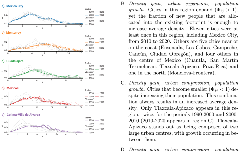
Mexico's urban population nearly doubled from 1990 to 2020, but populations shifted outward, resulting in a decline of 2.5 million residents in central areas. Distances from the city centre increased by 28 percent on average, driven by population losses in central zones combined with growth in peripheral regions. The radial probability density function and urban expansion factor provide a framework for comparing these changes over time and across regions.
What carries the argument
The radial probability density function combined with the urban expansion factor, which models population distribution at varying distances from the center and measures the degree of outward spread.
If this is right
- Central urban zones experience sustained population decline while outer zones absorb most new residents.
- The spatial configuration of cities becomes more spread out, increasing the physical extent of built-up areas.
- Urban form metrics based on distance from the center capture the combined effect of core losses and peripheral gains.
- The same model allows direct numerical comparison of expansion rates among different Mexican regions over the three decades.
Where Pith is reading between the lines
- Longer average distances from centers may raise daily travel requirements for residents even if total population grows.
- Similar radial-density analysis applied to other countries could test whether outward population shifts appear under comparable census conditions.
- Policy responses focused only on central revitalization may miss the larger peripheral growth that drives overall urban expansion.
Load-bearing premise
The radial probability density function and urban expansion factor can compare urban expansion reliably across time and regions without needing to adjust for variations in city boundaries or data accuracy.
What would settle it
A re-calculation of the 69 areas using fixed historical city boundaries that eliminates the reported 28 percent distance increase or the 2.5 million central population loss.
Figures


read the original abstract
Despite its pervasive implications, many cities worldwide continue to expand in a fragmented, horizontal manner. We analyse urban growth dynamics in 69 Mexican metropolitan areas from 1990 to 2020 using census data, developing a model of urban form change based on population size, density, and spatial configuration. We employ a radial probability density function and the urban expansion factor to create a framework for comparing urban expansion over time and across different regions. Over the past three decades, Mexico's urban population has nearly doubled. However, populations have shifted outward, resulting in a decline of 2.5 million residents in central areas. Our analysis shows that distances from the city centre have increased by 28% on average, driven by population losses in central zones combined with growth in peripheral regions.
Editorial analysis
A structured set of objections, weighed in public.
Referee Report
Summary. The manuscript analyzes urban growth dynamics in 69 Mexican metropolitan areas from 1990 to 2020 using census data. It develops a framework based on population size, density, and spatial configuration, employing a radial probability density function together with an urban expansion factor to compare expansion over time and regions. The central empirical claims are that urban population nearly doubled while central areas lost 2.5 million residents, producing a 28% average increase in distances from the city centre driven by central losses and peripheral gains.
Significance. If the boundary and robustness issues are resolved, the work would supply a multi-decade, multi-city empirical record of outward population shifts in Mexican urban centres, contributing to debates on horizontal urban expansion and its planning implications. The scale of the dataset (69 areas) offers potential for comparative insights, though the absence of error bars and validation currently limits the strength of the quantitative claims.
major comments (2)
- [Methods] Methods section (radial PDF and urban expansion factor): the framework does not describe any harmonization of time-varying metropolitan boundaries or fixed-boundary counterfactuals. Because Mexican census tracts and administrative definitions change between 1990 and 2020, the reported 28% distance increase and 2.5 M central loss could be driven by reclassification of peripheral tracts rather than genuine relocation; this directly affects the load-bearing claim that the model isolates outward shifts.
- [Results] Results (28% distance increase and central population loss): no error bars, confidence intervals, or sensitivity tests to radial binning choices or centre definitions are reported. Without these, it is impossible to evaluate whether the 28% figure is robust or sensitive to the PDF model assumptions.
minor comments (2)
- [Abstract] Abstract: the title refers to 'scaling' yet the abstract provides no explicit scaling relation or exponent; a brief statement of any scaling result would improve clarity.
- [Methods] Clarify the operational definition of 'city centre' and how it is held constant across the 69 areas and three decades.
Simulated Author's Rebuttal
We thank the referee for their constructive comments, which identify key areas where additional methodological detail and robustness checks will strengthen the manuscript. We respond to each major comment below and outline the revisions we will implement.
read point-by-point responses
-
Referee: [Methods] Methods section (radial PDF and urban expansion factor): the framework does not describe any harmonization of time-varying metropolitan boundaries or fixed-boundary counterfactuals. Because Mexican census tracts and administrative definitions change between 1990 and 2020, the reported 28% distance increase and 2.5 M central loss could be driven by reclassification of peripheral tracts rather than genuine relocation; this directly affects the load-bearing claim that the model isolates outward shifts.
Authors: We agree that explicit treatment of boundary changes is necessary. Our analysis employed the official INEGI metropolitan area definitions for each census year, but we did not previously detail potential reclassification effects. In the revised Methods section we will add a description of how we aligned tract-level data across years and include a fixed-boundary counterfactual restricted to metropolitan areas with stable delineations. This will allow us to quantify the contribution of administrative changes versus genuine population relocation to the reported 28% distance increase and central losses. revision: yes
-
Referee: [Results] Results (28% distance increase and central population loss): no error bars, confidence intervals, or sensitivity tests to radial binning choices or centre definitions are reported. Without these, it is impossible to evaluate whether the 28% figure is robust or sensitive to the PDF model assumptions.
Authors: We acknowledge that the current presentation lacks quantitative uncertainty measures and sensitivity tests. In the revised Results section we will add bootstrap-derived confidence intervals to the reported average distance increase and central population loss figures. We will also include sensitivity analyses that vary radial bin widths and test alternative centre definitions (geometric centroid versus population-weighted). These additions will demonstrate the robustness of the 28% figure to the modelling choices. revision: yes
Circularity Check
No circularity detected; results rest on direct census tabulations
full rationale
The paper analyzes 1990–2020 census data for 69 Mexican metropolitan areas, tabulating population shifts, central losses of 2.5 million, and a 28% average increase in distances from the city centre. It introduces a radial probability density function and urban expansion factor as a comparative framework, but no equations are shown that reduce these outputs to fitted parameters, self-citations, or ansatzes by construction. The central claims derive from external data processing rather than internal redefinition or prediction of inputs, making the derivation self-contained against the census benchmarks.
Axiom & Free-Parameter Ledger
Lean theorems connected to this paper
-
IndisputableMonolith/Foundation/RealityFromDistinction.leanreality_from_one_distinction unclear?
unclearRelation between the paper passage and the cited Recognition theorem.
We employ a radial probability density function and the urban expansion factor to create a framework for comparing urban expansion over time... ρ(s,tj)=1/Φij ρ(s/Φij,ti)
-
IndisputableMonolith/Cost/FunctionalEquation.leanwashburn_uniqueness_aczel unclear?
unclearRelation between the paper passage and the cited Recognition theorem.
Φij = (P(tj)/P(ti))^β e^{α(tj−ti)} ... β=0.60, α=0.0057
What do these tags mean?
- matches
- The paper's claim is directly supported by a theorem in the formal canon.
- supports
- The theorem supports part of the paper's argument, but the paper may add assumptions or extra steps.
- extends
- The paper goes beyond the formal theorem; the theorem is a base layer rather than the whole result.
- uses
- The paper appears to rely on the theorem as machinery.
- contradicts
- The paper's claim conflicts with a theorem or certificate in the canon.
- unclear
- Pith found a possible connection, but the passage is too broad, indirect, or ambiguous to say the theorem truly supports the claim.
Reference graph
Works this paper leans on
-
[1]
Population Division United Nations.World Ur- banization Prospects. 2023
work page 2023
-
[2]
Urban expansion: theory, evi- dence and practice
Shlomo Angel. “Urban expansion: theory, evi- dence and practice”. In:Buildings & Cities4.1 (2023)
work page 2023
-
[3]
A worldwide model for boundaries of urban settlements
Erneson A Oliveira et al. “A worldwide model for boundaries of urban settlements”. In:Royal Society Open Science5.5 (2018), p. 180468
work page 2018
-
[4]
Denise Pumain and Marianne Guerois. “Scaling laws in urban systems”. In:Santa Fe Institute, Working Papers. 2004, pp. 1–26
work page 2004
-
[5]
On the influence of density and morphology on the Urban Heat Island inten- sity
Yunfei Li et al. “On the influence of density and morphology on the Urban Heat Island inten- sity”. In:Nature Communications11.1 (2020), pp. 1–9
work page 2020
-
[6]
The role of city size and urban form in the sur- face urban heat island
Bin Zhou, Diego Rybski, and J¨ urgen P Kropp. “The role of city size and urban form in the sur- face urban heat island”. In:Scientific Reports 7.1 (2017), pp. 1–9
work page 2017
-
[7]
Introduction: Situating knowledge and action for an urban planet
Susan Parnell et al. “Introduction: Situating knowledge and action for an urban planet”. In:The Urban Planet: Knowledge Towards Sus- tainable Cities1 (2018), pp. 1–16
work page 2018
-
[8]
Human settlements, in- frastructure and spatial planning
Karen C Seto et al. “Human settlements, in- frastructure and spatial planning”. In:Climate Change 2014: Mitigation of Climate Change, Intergovernmental Panel on Climate Change IPCC1 (2014)
work page 2014
-
[9]
Alain Bertaud.Order without Design: How Markets Shape Cities. 2018
work page 2018
-
[10]
Urban Sprawl Is As- sociated with Reduced Access and Increased Costs of Water and Sanitation
Rafael Prieto-Curiel, Pavel Luengas-Sierra, and Christian Borja-Vega. “Urban Sprawl Is As- sociated with Reduced Access and Increased Costs of Water and Sanitation”. In:arXiv (2025). eprint:2402 . 06676.url:https : / / arxiv.org/abs/2402.06676
-
[11]
Infrastructure deficits and informal settle- ments in sub-Saharan Africa
Lu´ ıs MA Bettencourt and Nicholas Marchio. “Infrastructure deficits and informal settle- ments in sub-Saharan Africa”. In:Nature (2025), pp. 1–8
work page 2025
-
[12]
The structure of urban equi- libria: a unified treatment of the Muth-Mills model
Jank Brueckner. “The structure of urban equi- libria: a unified treatment of the Muth-Mills model”. In:Handbook of Regional and Urban Economics2 (1986), p. 821
work page 1986
-
[13]
Scaling of the morphol- ogy of African cities
Rafael Prieto-Curiel, Jorge E Patino, and Bril´ e Anderson. “Scaling of the morphol- ogy of African cities”. In:Proceedings of the National Academy of Sciences120.9 (2023), e2214254120
work page 2023
-
[14]
A longitudinal study of changes in urban sprawl between 2000 and 2010 in the United States
Shima Hamidi and Reid Ewing. “A longitudinal study of changes in urban sprawl between 2000 and 2010 in the United States”. In:Landscape and urban planning128 (2014), pp. 72–82
work page 2000
-
[15]
Jianxin Yang et al. “Simulating urban expan- sion using cellular automata model with spa- tiotemporally explicit representation of urban demand”. In:Landscape and Urban Planning 231 (2023), p. 104640
work page 2023
-
[16]
The SLEUTH land use change model: A review
Gargi Chaudhuri and Keith Clarke. “The SLEUTH land use change model: A review”. In: Environmental Resources Research1.1 (2013), pp. 88–105
work page 2013
-
[17]
Measuring sprawl and its impacts: An update
Shima Hamidi et al. “Measuring sprawl and its impacts: An update”. In:Journal of Planning Education and Research35.1 (2015), pp. 35–50. 18
work page 2015
-
[18]
Edward L Glaeser and Matthew E Kahn.De- centralized employment and the transformation of the American city. 2001
work page 2001
-
[19]
The spatial structure of US metropolitan employment: New insights from administrative data
Robert Manduca. “The spatial structure of US metropolitan employment: New insights from administrative data”. In:Environment and Planning B: Urban Analytics and City Sci- ence48.5 (2021), pp. 1357–1372
work page 2021
-
[20]
The planners’ war against spa- tial mismatch: Lessons learned and ways for- ward
Yingling Fan. “The planners’ war against spa- tial mismatch: Lessons learned and ways for- ward”. In:Journal of Planning Literature27.2 (2012), pp. 153–169
work page 2012
-
[21]
Travel and the built environment: A meta-analysis
Reid Ewing and Robert Cervero. “Travel and the built environment: A meta-analysis”. In: Journal of the American planning association 76.3 (2010), pp. 265–294
work page 2010
-
[22]
Colin Clark. “Urban Population Densities”. In:Journal of the Royal Statistical Society. Series A (General)114.4 (1951). Publisher: [Royal Statistical Society, Wiley], pp. 490–496. issn: 0035-9238.doi:10.2307/2981088.url: https : / / www . jstor . org / stable / 2981088 (visited on 04/01/2025)
-
[23]
The Spatial Variation of Urban Population Densities
Bruce E. Newling. “The Spatial Variation of Urban Population Densities”. In:Geographical Review59.2 (1969). Publisher: Taylor & Fran- cis, Ltd., pp. 242–252.issn: 0016-7428.doi: 10.2307/213456.url:https://www.jstor. org/stable/213456(visited on 04/08/2025)
-
[24]
Form Fol- lows Function: Reformulating Urban Popula- tion Density Functions
Michael Batty and Kwang Sik Kim. “Form Fol- lows Function: Reformulating Urban Popula- tion Density Functions”. en. In:Urban Stud- ies29.7 (Oct. 1992). Publisher: SAGE Publica- tions Ltd, pp. 1043–1069.issn: 0042-0980.doi: 10.1080/00420989220081041.url:https:// doi.org/10.1080/00420989220081041(vis- ited on 02/24/2025)
-
[25]
Urban Population Densi- ties: Structure and Change
Brian J. L. Berry, James W. Simmons, and Robert J. Tennant. “Urban Population Densi- ties: Structure and Change”. In:Geographical Review53.3 (1963). Publisher: [American Ge- ographical Society, Wiley], pp. 389–405.issn: 0016-7428.doi:10.2307/212588.url:https: //www.jstor.org/stable/212588(visited on 01/31/2025)
-
[26]
Modelling urban growth pat- terns
Hern´ an A Makse, Shlomo Havlin, and H Eu- gene Stanley. “Modelling urban growth pat- terns”. In:Nature377.6550 (1995), pp. 608– 612
work page 1995
-
[27]
Ottensmann.The Decline of the Density Gradient is Not a Good Measure of Decentralization
John R. Ottensmann.The Decline of the Density Gradient is Not a Good Measure of Decentralization. en. SSRN Scholarly Paper. Rochester, NY, June 2022.doi:10 . 2139 / ssrn . 4139820.url:https : / / papers . ssrn . com / abstract = 4139820(visited on 01/31/2025)
work page 2022
-
[28]
Official Website from INEGI.Census Data from Mexico, 1990-2020.http://www.inegi. org.mx/. Accessed on July 2021. 2021
work page 1990
-
[29]
Density gradients and their determinants: Evidence from India
Kala Seetharam Sridhar. “Density gradients and their determinants: Evidence from India”. In:Regional Science and Urban Economics37.3 (May 2007), pp. 314–344.issn: 0166-0462.doi: 10.1016/j.regsciurbeco.2006.11.001.url: https://www.sciencedirect.com/science/ article/pii/S0166046206000974(visited on 04/08/2025)
-
[30]
The at- traction of urban cores: Densification in Dutch city centres
Dani Broitman and Eric Koomen. “The at- traction of urban cores: Densification in Dutch city centres”. EN. In:Urban Studies57.9 (July 2020). Publisher: SAGE Publications Ltd, pp. 1920–1939.issn: 0042-0980.doi:10. 1177/0042098019864019.url:https://doi. org/10.1177/0042098019864019(visited on 04/08/2025)
-
[31]
Rodrigo Jim´ enez Uribe et al.Metr´ opolis de M´ exico 2020. Spanish. 1st ed. Secretar´ ıa de Desarrollo Agrario, Territorial y Urbano, Oct. 2023.isbn: 978-607-98208-2-4
work page 2020
-
[32]
Comparing urban form in- fluences on travel distance, car ownership, and mode choice
Peter Berrill et al. “Comparing urban form in- fluences on travel distance, car ownership, and mode choice”. In:Transportation Research Part D: Transport and Environment128 (2024), p. 104087. 19
work page 2024
-
[33]
Tamara Iungman et al. “The impact of urban configuration types on urban heat islands, air pollution, CO2 emissions, and mortality in Eu- rope: a data science approach”. In:The Lancet Planetary Health8.7 (2024), e489–e505.issn: 2542-5196.doi:https://doi.org/10.1016/ S2542-5196(24)00120-7.url:https://www. sciencedirect.com/science/article/pii/ S2542519624001207
work page 2024
-
[34]
Rafael Prieto-Curiel. “Weekly crime concentra- tion”. In:Journal of Quantitative Criminology 39.1 (2023), pp. 97–124
work page 2023
-
[35]
The growth of the city: an introduction to a research project
Ernest W Burgess. “The growth of the city: an introduction to a research project”. In:The trend of population. Chicago, USA: American Sociological Society, 1925, pp. 212–220
work page 1925
-
[36]
The new geography of con- temporary urbanization and the environment
Karen C Seto, Roberto S´ anchez-Rodr´ ıguez, and Michail Fragkias. “The new geography of con- temporary urbanization and the environment”. In:Annual Review of Environment and Re- sources35.1 (2010), pp. 167–194
work page 2010
-
[37]
Rosanna Salvia et al. “From Rural Spaces to Peri-Urban Districts: Metropolitan Growth, Sparse Settlements and Demographic Dynam- ics in a Mediterranean Region”. In:Land 9.6 (2020).issn: 2073-445X.doi:10 . 3390 / land9060200.url:https://www.mdpi.com/ 2073-445X/9/6/200
work page 2020
-
[38]
Self-organization and the city
Juval Portugali. “Self-organization and the city”. In:Encyclopedia of complexity and sys- tems science. Springer, 2017, pp. 1–49
work page 2017
-
[39]
Ralf Metzler et al. “Anomalous diffusion mod- els and their properties: non-stationarity, non- ergodicity, and ageing at the centenary of sin- gle particle tracking”. In:Physical Chemistry Chemical Physics16.44 (2014), pp. 24128– 24164
work page 2014
-
[40]
Shlomo Angel et al.Accommodating Urban Growth in Latin American and Caribbean Cities. 2025.doi:10 . 18235 / 0013550.url: https://doi.org/10.18235/0013550
-
[41]
Simon Elias Bibri, John Krogstie, and Mattias K¨ arrholm. “Compact city planning and devel- opment: Emerging practices and strategies for achieving the goals of sustainability”. In:De- velopments in the built environment4 (2020), p. 100021
work page 2020
-
[42]
Billie Giles-Corti et al. “What next? Expand- ing our view of city planning and global health, and implementing and monitoring evidence- informed policy”. In:The Lancet global health 10.6 (2022), e919–e926
work page 2022
-
[43]
The eco- nomics of urban density
Gilles Duranton and Diego Puga. “The eco- nomics of urban density”. In:Journal of eco- nomic perspectives34.3 (2020), pp. 3–26
work page 2020
-
[44]
Erick Guerra et al. “Urban form, transit sup- ply, and travel behavior in Latin America: Ev- idence from Mexico’s 100 largest urban areas”. In:Transport Policy69 (2018), pp. 98–105
work page 2018
-
[45]
Urban Shrinkage and sub- urbanization in Mexico: A view based on the last census data
Simone Di Pietro. “Urban Shrinkage and sub- urbanization in Mexico: A view based on the last census data”. In:Iberoamericana–Nordic Journal of Latin American and Caribbean Stud- ies50.1 (2021)
work page 2021
-
[46]
Yoonhee Kim and Bontje Zangerling.Mexico urbanization review: Managing spatial growth for productive and livable cities in Mexico. World Bank Publications, 2016
work page 2016
-
[47]
Alejandrina P´ erez Ayala and M del Carmen M´ ınguez Garc´ ıa. “¿Por Qu´ e Vivir En El Cen- tro Hist’orico? Motivos De Permanencia Desde La Percepci´ on De Los Habitantes.” In:Proce- sos Urbanos Y Metropolitanos En La Mundial- izaci´ on De Las Crisis. Cartograf´ ıa De Las Es- trategias Locales De Resistencia()
-
[48]
Do Mexican cities sprawl? Housing-finance reform and changing patterns of urban growth
Paavo Monkkonen. “Do Mexican cities sprawl? Housing-finance reform and changing patterns of urban growth”. In:Urban Geography32.3 (2011), pp. 406–423
work page 2011
-
[49]
Growth, innova- tion, scaling, and the pace of life in cities
Luis MA Bettencourt et al. “Growth, innova- tion, scaling, and the pace of life in cities”. In: PNAS104.17 (2007), pp. 7301–7306. 20
work page 2007
-
[50]
The origins of scaling in cities
Lu´ ıs MA Bettencourt. “The origins of scaling in cities”. In:Science340.6139 (2013), pp. 1438– 1441
work page 2013
-
[51]
The interpretation of urban scaling analysis in time
Lu´ ıs MA Bettencourt et al. “The interpretation of urban scaling analysis in time”. In:Journal of the Royal Society Interface17.163 (2020), p. 20190846
work page 2020
-
[52]
On the relation be- tween transversal and longitudinal scaling in cities
Fabiano L Ribeiro et al. “On the relation be- tween transversal and longitudinal scaling in cities”. In:PloS one15.5 (2020), e0233003
work page 2020
-
[53]
Marcello Schiavina, Sergio Freire, and Kytt MacManus.GHS-POP R2023A - GHS popula- tion grid multitemporal (1975-2030). en. 2023. doi:10 . 2905 / 2FF68A52 - 5B5B - 4A22 - 8F40 - C41DA8332CFE.url:http : / / data . europa . eu / 89h / 2ff68a52 - 5b5b - 4a22 - 8f40 - c41da8332cfe
work page 1975
-
[54]
WorldPop, open data for spatial demography
Andrew J Tatem. “WorldPop, open data for spatial demography”. In:Scientific data4.1 (2017), pp. 1–4
work page 2017
-
[55]
GHS-POP Accuracy Assessment: Poland and Portugal Case Study
Beata Calka and Elzbieta Bielecka. “GHS-POP Accuracy Assessment: Poland and Portugal Case Study”. In:Remote Sensing12.7 (2020). issn: 2072-4292.doi:10 . 3390 / rs12071105. url:https://www.mdpi.com/2072-4292/12/ 7/1105
work page 2020
-
[56]
Global pop- ulation datasets overestimate flood exposure in Sweden
Konstantinos Karagiorgos et al. “Global pop- ulation datasets overestimate flood exposure in Sweden”. In:Scientific Reports14.1 (2024), p. 20410
work page 2024
-
[57]
Implications for track- ing SDG indicator metrics with gridded pop- ulation data
Cascade Tuholske et al. “Implications for track- ing SDG indicator metrics with gridded pop- ulation data”. In:Sustainability13.13 (2021), p. 7329
work page 2021
-
[58]
Stefan Leyk et al. “The spatial allocation of population: a review of large-scale gridded pop- ulation data products and their fitness for use”. In:Earth System Science Data11.3 (2019), pp. 1385–1409
work page 2019
-
[59]
Building a multi-temporal urban population grid for Mexico: the why and the how
Rodolfo Soriano and Gonzalo Peraza-Mues. “Building a multi-temporal urban population grid for Mexico: the why and the how”. In: 19th International Conference on Computers in Urban Planning and Urban Management, CUPUM 2025. CUPUM. 2025
work page 2025
-
[60]
´Areas Geoestad´ ısticas B´ asicas Urbanas.https : / / www.inegi.org.mx/temas/mg/
INEGI.Marco Geoestad´ ıstico Nacional. ´Areas Geoestad´ ısticas B´ asicas Urbanas.https : / / www.inegi.org.mx/temas/mg/
-
[61]
Daniele Ehrlich et al. “Open and consistent geospatial data on population density, built-up and settlements to analyse human presence, so- cietal impact and sustainability: A review of GHSL applications”. In:Sustainability13.14 (2021), p. 7851
work page 2021
-
[62]
Flood exposure and poverty in 188 countries
Jun Rentschler, Melda Salhab, and Bramka Arga Jafino. “Flood exposure and poverty in 188 countries”. In:Nature communications13.1 (2022), p. 3527
work page 2022
-
[63]
Lewis Dijkstra et al. “Applying the degree of urbanisation to the globe: A new harmonised definition reveals a different picture of global urbanisation”. In:Journal of Urban Economics 125 (2021), p. 103312
work page 2021
-
[64]
Jorge Alberto Montejano Escamilla, Gerardo Avila Jim´ enez, and Camilo Alberto Caudillo Cos. “Estandarizaci´ on de las ´ areas geoes- tad´ ısticas b´ asicas urbanas para 100 ciudades del Sistema Urbano Nacional”. In:Realidad, datos y espacio. Revista internacional de es- tad´ ıstica y geograf´ ıa11.3 (2020)
work page 2020
-
[65]
Landmark-based elastic registration using approximating thin-plate splines
Karl Rohr et al. “Landmark-based elastic registration using approximating thin-plate splines”. In:IEEE Transactions on medical imaging20.6 (2001), pp. 526–534
work page 2001
-
[66]
INEGI.Metodolog´ ıa de la malla para la publi- caci´ on de informaci´ on estad´ ıstica y geogr´ afica. 2023
work page 2023
-
[67]
Radial analysis and scaling of urban land use
R´ emi Lemoy and Geoffrey Caruso. “Radial analysis and scaling of urban land use”. In:Sci- entific Reports11.1 (2021), p. 22044. 21
work page 2021
-
[68]
Evidence for the homothetic scaling of urban forms
R´ emi Lemoy and Geoffrey Caruso. “Evidence for the homothetic scaling of urban forms”. In: Environment and Planning B: Urban Analytics and City Science47.5 (2020), pp. 870–888
work page 2020
-
[69]
Dynamic models of seg- regation
Thomas C Schelling. “Dynamic models of seg- regation”. In:Journal of Mathematical Sociol- ogy1.2 (1971), pp. 143–186
work page 1971
-
[70]
African dreams: locating urban in- frastructure in the 2030 sustainable develop- mental agenda
Edgar Pieterse, Susan Parnell, and Gareth Haysom. “African dreams: locating urban in- frastructure in the 2030 sustainable develop- mental agenda”. In:Area Development and Policy3.2 (2018), pp. 149–169. 22 Supplementary Information 1 Identifying the city centre and the central parts We identify the city centre as the historical point where each city initi...
work page 2030
discussion (0)
Sign in with ORCID, Apple, or X to comment. Anyone can read and Pith papers without signing in.