Recognition: no theorem link
Spatial Analysis on Value-Based Quadtrees of Rasterized Vector Data
Pith reviewed 2026-05-15 00:31 UTC · model grok-4.3
The pith
A value-based quadtree on rasterized vector data cuts median point-in-polygon query latency by 90 percent while preserving accuracy.
A machine-rendered reading of the paper's core claim, the machinery that carries it, and where it could break.
Core claim
We contribute a value-based quadtree index that serves as a bridge builder to support joint spatial analysis on vector and raster data leveraging their unique autocorrelation property. This index is constructed on rasterized vector data and delivers a 90 percent reduction in median point-in-polygon query latency while keeping the accuracy of query responses at equal level.
What carries the argument
Value-based quadtree index that partitions rasterized space according to value similarity and autocorrelation to accelerate point-in-polygon checks.
If this is right
- Joint analysis of vector mobility traces and raster weather layers becomes practical at interactive speeds
- Point-in-polygon queries complete with 90 percent lower median latency
- Accuracy remains equivalent to pure vector methods
- Exploratory workflows no longer require full format conversion between vector and raster representations
Where Pith is reading between the lines
- The same indexing idea could be tested on other spatial operations such as range counts or nearest-neighbor searches
- Datasets with weaker autocorrelation may show smaller speedups or accuracy trade-offs
- Integration into existing GIS or database engines would let practitioners apply the method without custom code
Load-bearing premise
The underlying spatial data must possess a unique autocorrelation property that the value-based quadtree can exploit to keep query accuracy intact after vector data is rasterized.
What would settle it
Run the same point-in-polygon queries on the original vector data with a standard library and compare both accuracy and median latency against the quadtree results on the rasterized version; a statistically significant accuracy drop would falsify the claim.
Figures


read the original abstract
Mobility data science offers insights into the complex interconnections of spatial data of moving objects and their surroundings, often based on a combination of vector and raster data. For example, mobility traces are usually in vector format, weather data are often in raster format. Yet, available spatial analysis tools for exploratory data science push data scientists towards one or the other, providing only limited support for the respective other. In this paper, we contribute to this problem space with a value-based quadtree index, which serves as a bridge builder to support joint spatial analysis on vector and raster data leveraging their unique autocorrelation property. We achieve a 90% reduction in median Point-in-Polygon query latency, while keeping the accuracy of query responses at equal level.
Editorial analysis
A structured set of objections, weighed in public.
Referee Report
Summary. The paper introduces a value-based quadtree index for rasterized vector data to enable joint spatial analysis with raster data in mobility applications. It claims this construction exploits spatial autocorrelation to deliver a 90% reduction in median Point-in-Polygon query latency while preserving query accuracy at the level of the original vector representation.
Significance. If the accuracy claim holds under the stated autocorrelation assumptions, the result would be significant for mobility data science by providing a practical bridge between vector and raster formats without forcing a choice between them or incurring accuracy loss. The reported latency improvement is large enough to be practically relevant for exploratory analysis workloads.
major comments (2)
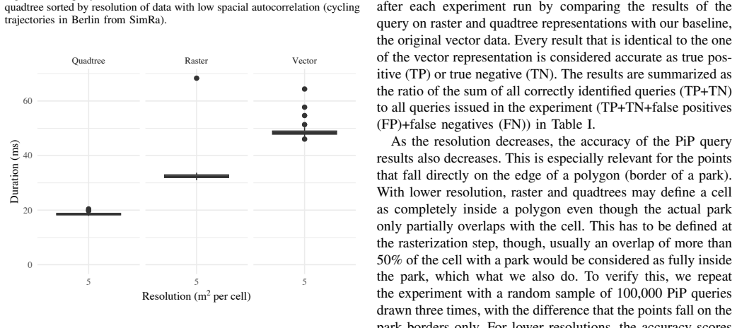
- [Abstract] Abstract: the central claim of 90% median PiP latency reduction with equal accuracy is stated without any experimental details, baselines, datasets, error bars, resolution parameters, or direct vector-vs-raster accuracy comparison. This prevents verification of the result and leaves the autocorrelation assumption untested.
- [Abstract] The accuracy preservation after rasterization is asserted to rely on a 'unique autocorrelation property,' yet no formal error bound, resolution-selection rule, or quantitative characterization of when discretization preserves PiP decisions is supplied. If autocorrelation is weaker than assumed, the equal-accuracy side of the claim fails.
minor comments (1)
- [Abstract] The abstract would be strengthened by a single sentence naming the datasets or query workloads used to obtain the 90% figure.
Simulated Author's Rebuttal
We thank the referee for the constructive feedback highlighting the need for greater transparency in the abstract and additional characterization of the autocorrelation property. We address each comment below and have made revisions to strengthen the presentation of results and methodology.
read point-by-point responses
-
Referee: [Abstract] Abstract: the central claim of 90% median PiP latency reduction with equal accuracy is stated without any experimental details, baselines, datasets, error bars, resolution parameters, or direct vector-vs-raster accuracy comparison. This prevents verification of the result and leaves the autocorrelation assumption untested.
Authors: We agree the abstract's brevity omits key experimental specifics. The full manuscript details the evaluation setup in Section 5, including mobility trace datasets from urban environments, direct comparisons to vector-based PiP using standard libraries, error bars computed over repeated runs, and raster resolutions tested at multiple scales. Accuracy is compared via exact match rates between vector and rasterized representations. We have revised the abstract to reference the primary datasets and evaluation parameters while preserving its summary nature. revision: yes
-
Referee: [Abstract] The accuracy preservation after rasterization is asserted to rely on a 'unique autocorrelation property,' yet no formal error bound, resolution-selection rule, or quantitative characterization of when discretization preserves PiP decisions is supplied. If autocorrelation is weaker than assumed, the equal-accuracy side of the claim fails.
Authors: The original manuscript presents the accuracy claim through empirical results on datasets exhibiting typical mobility autocorrelation rather than a formal error bound, which would require restrictive distributional assumptions. We have added a new subsection providing a quantitative characterization: a resolution-selection heuristic derived from sample variograms to quantify autocorrelation strength, together with controlled experiments demonstrating PiP accuracy retention thresholds and degradation under reduced autocorrelation. This makes the conditions for equal accuracy explicit. revision: yes
Circularity Check
No significant circularity; new index construction is independent of its inputs
full rationale
The paper introduces a value-based quadtree as a novel bridge between vector and raster data, leveraging an autocorrelation property to achieve latency reduction while preserving accuracy. No equations or steps in the provided text reduce a claimed prediction or result to a fitted parameter, self-citation chain, or definitional tautology. The central claim rests on an empirical property of the data rather than a derivation that is equivalent to its own assumptions by construction. This is the expected non-finding for a construction paper whose index is presented as an independent artifact.
Axiom & Free-Parameter Ledger
axioms (1)
- domain assumption Spatial data exhibits a unique autocorrelation property that enables accurate queries after rasterization
invented entities (1)
-
value-based quadtree index
no independent evidence
Reference graph
Works this paper leans on
-
[1]
A Survey on Spatio-temporal Data Analytics Systems,
M. M. Alam, L. Torgo, and A. Bifet, “A Survey on Spatio-temporal Data Analytics Systems,”ACM Comput. Surv., 2022
work page 2022
-
[2]
A Survey on Big Data Processing Frameworks for Mobility Analytics,
C. Doulkeridis, A. Vlachou, N. Pelekis, and Y . Theodor- idis, “A Survey on Big Data Processing Frameworks for Mobility Analytics,”SIGMOD Rec., vol. 50, no. 2, p. 18–29, Aug. 2021
work page 2021
-
[3]
ST-Hadoop: A MapReduce Framework for Big Spatio-temporal Data,
L. Alarabi, “ST-Hadoop: A MapReduce Framework for Big Spatio-temporal Data,” inProceedings of the 2017 ACM International Conference on Management of Data, ser. SIGMOD ’17. New York, NY , USA: Association for Computing Machinery, 2017, p. 40–42. [Online]. Available: https://doi.org/10.1145/3055167.3055181
-
[4]
Simba: Efficient In-Memory Spatial Analytics,
D. Xie, F. Li, B. Yao, G. Li, L. Zhou, and M. Guo, “Simba: Efficient In-Memory Spatial Analytics,” in Proceedings of the 2016 International Conference on Management of Data, ser. SIGMOD ’16. New York, NY , USA: Association for Computing Machinery, 2016, p. 1071–1085. [Online]. Available: https://doi.org/10. 1145/2882903.2915237
-
[5]
A Demonstration of Summit: a Scalable Data Management Framework for Massive Trajectory,
L. Alarabi and M. F. Mokbel, “A Demonstration of Summit: a Scalable Data Management Framework for Massive Trajectory,” in2020 21st IEEE International Conference on Mobile Data Management (MDM), 2020, pp. 226–227
work page 2020
-
[6]
The multidimensional database system RasDaMan,
P. Baumann, A. Dehmel, P. Furtado, R. Ritsch, and N. Widmann, “The multidimensional database system RasDaMan,” inProceedings of the 1998 ACM SIGMOD International Conference on Management of Data, ser. SIGMOD ’98. New York, NY , USA: Association for Computing Machinery, 1998, p. 575–577. [Online]. Available: https://doi.org/10.1145/276304.276386
-
[7]
SciDB: A Database Management System for Applica- tions with Complex Analytics,
M. Stonebraker, P. Brown, D. Zhang, and J. Becla, “SciDB: A Database Management System for Applica- tions with Complex Analytics,”Computing in Science & Engineering, vol. 15, no. 3, pp. 54–62, 2013
work page 2013
-
[8]
Large Scale Analytics of Vector+Raster Big Spatial Data,
A. Eldawy, L. Niu, D. Haynes, and Z. Su, “Large Scale Analytics of Vector+Raster Big Spatial Data,” in Proceedings of the 25th ACM SIGSPATIAL International Conference on Advances in Geographic Information Systems, ser. SIGSPATIAL ’17. New York, NY , USA: Association for Computing Machinery, 2017. [Online]. Available: https://doi.org/10.1145/3139958.3140042
-
[9]
The Raptor Join Operator for Processing Big Raster + Vector Data,
S. Singla, A. Eldawy, T. Diao, A. Mukhopadhyay, and E. Scudiero, “The Raptor Join Operator for Processing Big Raster + Vector Data,” inProceedings of the 29th International Conference on Advances in Geographic Information Systems, ser. SIGSPATIAL ’21. New York, NY , USA: Association for Computing Machinery, 2021, p. 324–335. [Online]. Available: https://d...
-
[10]
RDPro: Distributed Processing of Big Raster Data,
Z. Shang, S. Singla, A. Eldawy, and E. Scudiero, “RDPro: Distributed Processing of Big Raster Data,” Proc. VLDB Endow., vol. 18, no. 3, p. 613–622, Nov. 2024. [Online]. Available: https://doi.org/10.14778/ 3712221.3712229
-
[11]
Geographic information systems & sci- ence,
P. A. Longley, “Geographic information systems & sci- ence,” Hoboken, NJ, 2011
work page 2011
-
[12]
The Quadtree and Related Hierarchical Data Structures,
H. Samet, “The Quadtree and Related Hierarchical Data Structures,”ACM Comput. Surv., vol. 16, no. 2, p. 187–260, Jun. 1984. [Online]. Available: https: //doi.org/10.1145/356924.356930
-
[13]
H. Liang, Z. Zhang, C. Hu, Y . Gong, and D. Cheng, “A Survey on Spatio-Temporal Big Data Analytics Ecosys- tem: Resource Management, Processing Platform, and Applications,”IEEE Transactions on Big Data, 2024
work page 2024
-
[14]
Simra: Using crowdsourcing to identify near miss hotspots in bicycle traffic,
A.-S. Karakaya, J. Hasenburg, and D. Bermbach, “Simra: Using crowdsourcing to identify near miss hotspots in bicycle traffic,”Elsevier Pervasive and Mobile Computing, vol. 67, p. 101197, Sep. 2020. [Online]. Available: https://doi.org/10.1016/j.pmcj.2020.101197
-
[15]
Efficient spatial queries over complex polygons with hybrid representations,
D. Teng, F. Baig, Z. Peng, J. Kong, and F. Wang, “Efficient spatial queries over complex polygons with hybrid representations,”GeoInformatica, vol. 28, no. 3, pp. 459–497, Jul. 2024. [Online]. Available: https: //link.springer.com/10.1007/s10707-023-00508-2
-
[16]
Efficient Indexing of Spatiotemporal Objects,
M. Hadjieleftheriou, G. Kollios, V . J. Tsotras, and D. Gunopulos, “Efficient Indexing of Spatiotemporal Objects,” inAdvances in Database Technology — EDBT 2002, C. S. Jensen, S. ˇSaltenis, K. G. Jeffery, J. Pokorny, E. Bertino, K. B ¨ohn, and M. Jarke, Eds. Berlin, Heidelberg: Springer Berlin Heidelberg, 2002, pp. 251– 268
work page 2002
-
[17]
A crowdsensing approach for deriving surface quality of cycling infrastructure,
A.-S. Karakaya, L. Thomas, D. Koljada, and D. Bermbach, “A crowdsensing approach for deriving surface quality of cycling infrastructure,” inProceedings of the 11th IEEE International Conference on Cloud Engineering, ser. IC2E ’23. New York, NY , USA: IEEE, Sep. 2023, pp. 212–219. [Online]. Available: https://doi.org/10.1109/IC2E59103.2023.00031
-
[18]
Quadtree-based lightweight data compression for large-scale geospatial rasters on multi-core CPUs,
J. Zhang, S. You, and L. Gruenwald, “Quadtree-based lightweight data compression for large-scale geospatial rasters on multi-core CPUs,” in2015 IEEE International Conference on Big Data (Big Data), 2015, pp. 478–484
work page 2015
discussion (0)
Sign in with ORCID, Apple, or X to comment. Anyone can read and Pith papers without signing in.