The Moving Target of Urban Equity: Spatiotemporal Demand and Double Disadvantage in Hefei, China
Pith reviewed 2026-06-26 15:20 UTC · model grok-4.3
The pith
Urban inequality depends on shifting daily population flows rather than fixed service locations.
A machine-rendered reading of the paper's core claim, the machinery that carries it, and where it could break.
Core claim
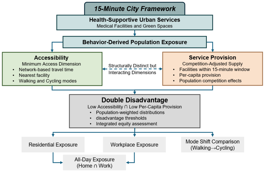
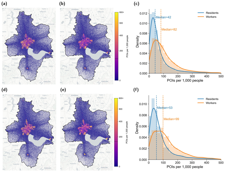
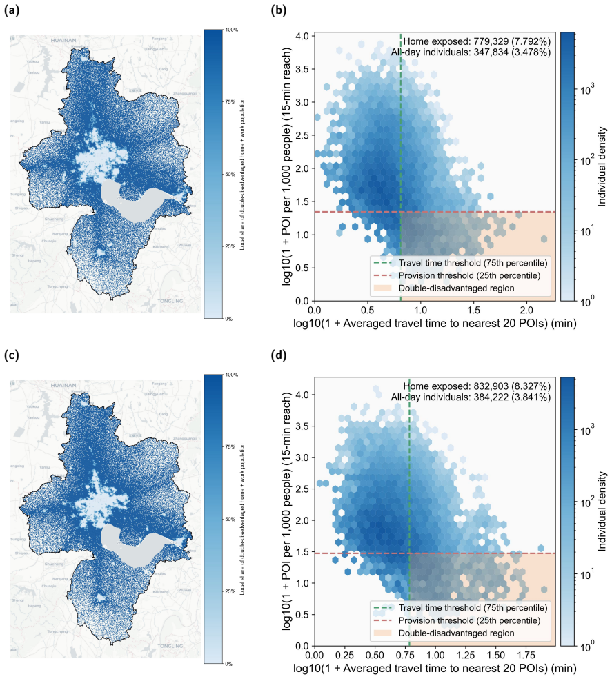
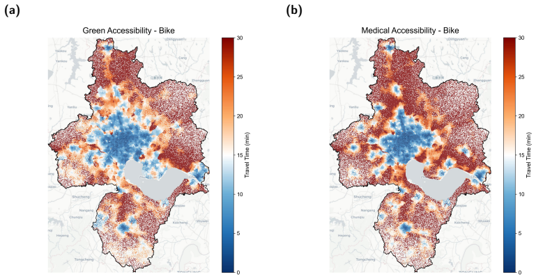
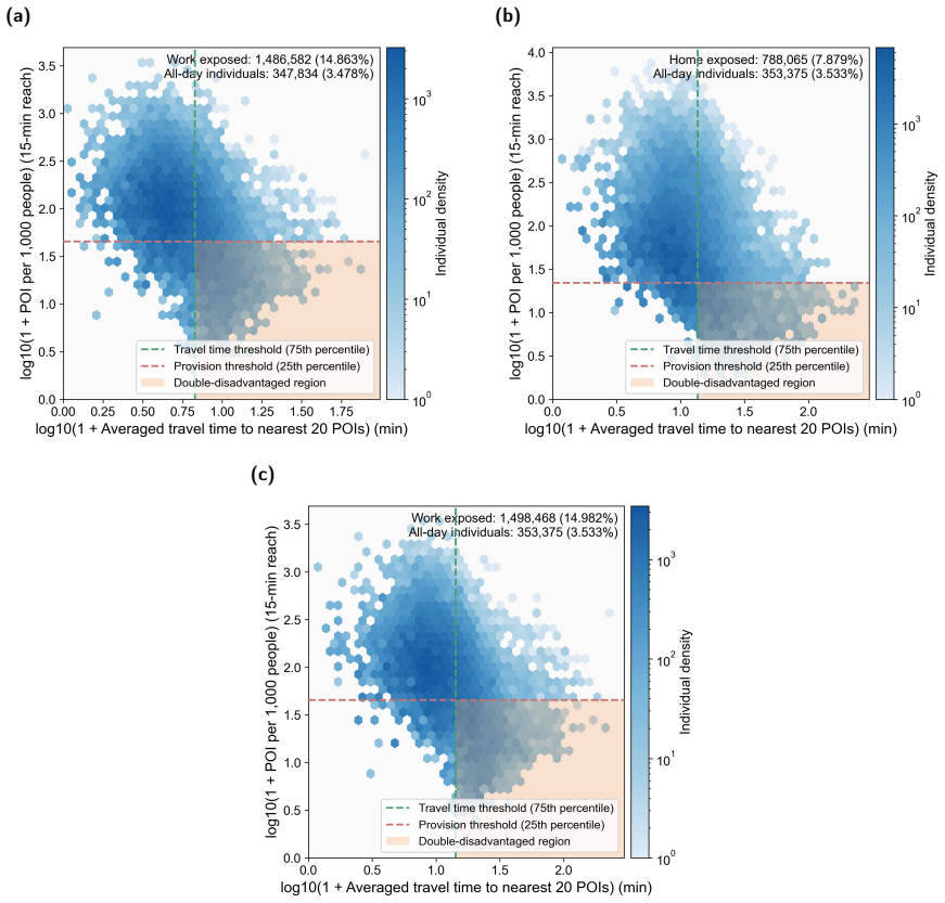
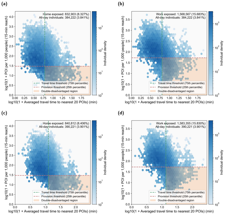
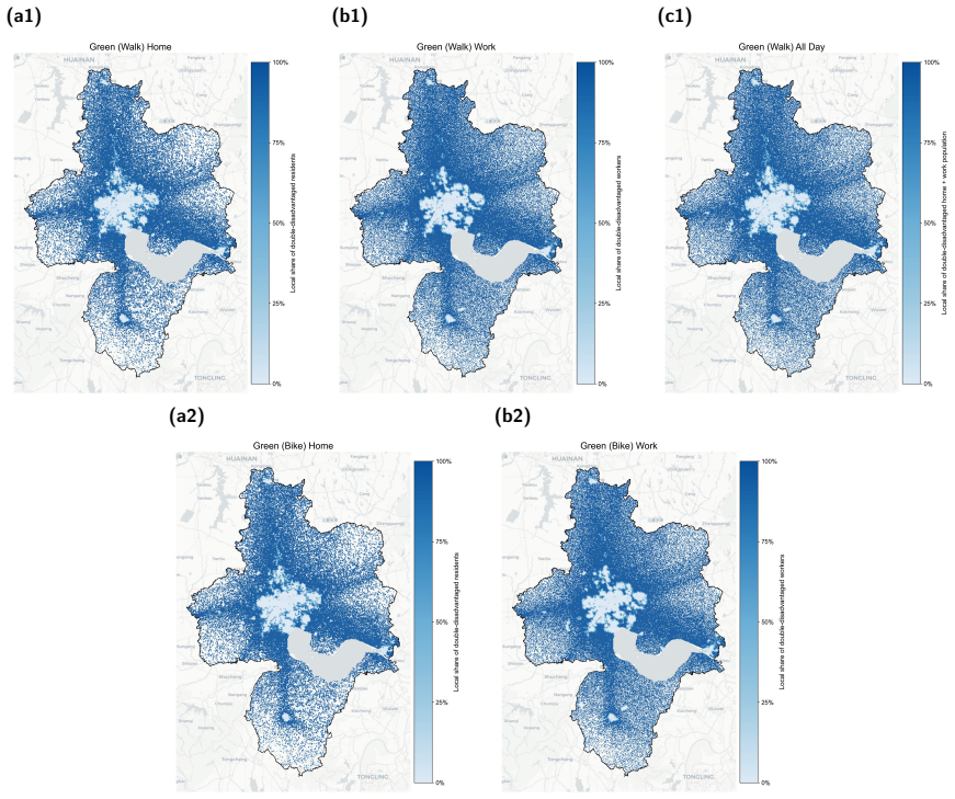
Urban equity is a moving target shaped by spatiotemporal population flows; double disadvantage, defined as the joint occurrence of poor spatial accessibility and low per-capita service availability, clusters mainly along the inner suburban belt rather than the remote periphery, and temporal shifts in workplace populations intensify demand competition in job centers.
What carries the argument
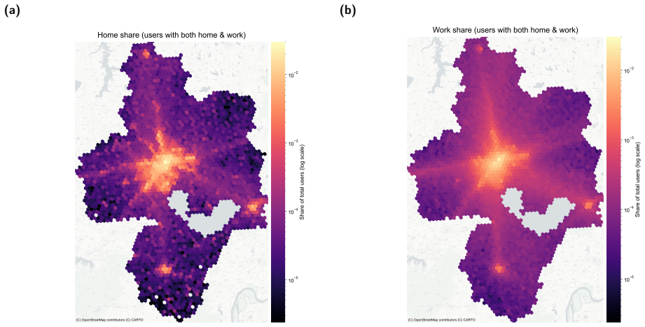
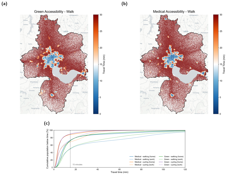
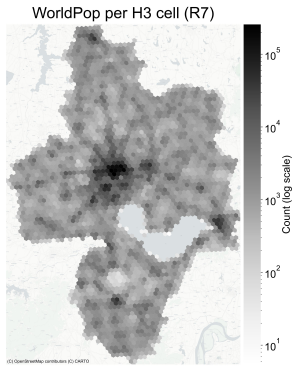
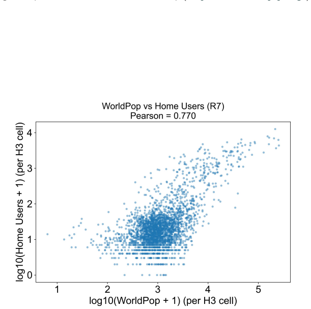
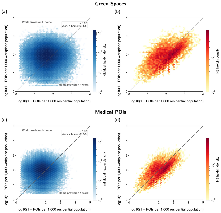
A population-based, temporally differentiated framework that constructs dynamic residential and workplace population exposure surfaces from mobile phone GPS data, then pairs network travel times with a per-capita provision metric that incorporates real-time demand competition.
If this is right
- Double-disadvantaged zones appear primarily in the inner suburban belt, not the distant outskirts.
- Daytime workplace concentrations create intense competition for services inside job centers.
- Static home-based planning metrics systematically understate or mislocate equity shortfalls.
- Effective interventions must target time-specific demand rather than permanent facility placement alone.
Where Pith is reading between the lines
- The same mobile-data approach could be applied to other Chinese cities or to non-Chinese metros to test whether inner-suburban double disadvantage is a general pattern.
- Planners could experiment with time-of-day service adjustments, such as mobile clinics or extended green-space hours, and measure whether they reduce the double-disadvantage metric.
- If workplace population data become routinely available, equity audits might shift from one-time residential maps to recurring hourly dashboards.
Load-bearing premise
Large-scale mobile phone GPS data accurately represent the hourly residential and workplace locations of the entire population without meaningful sampling bias or gaps.
What would settle it
A direct comparison showing that census or survey data produce hourly population distributions that differ substantially from the GPS-derived surfaces in the locations and timing of peak demand.
Figures
read the original abstract
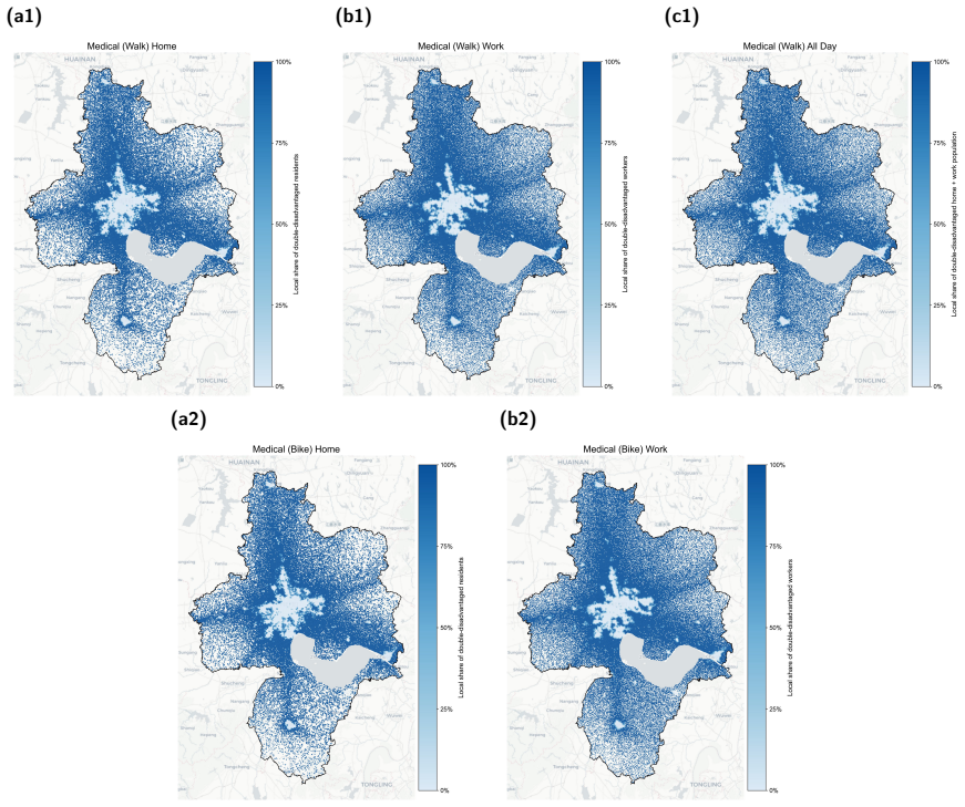
Equitable access to essential urban services is a pillar of modern planning, yet most accessibility models rely strictly on static residential locations, ignoring how demand shifts throughout the daily loop. This study introduces a population-based, temporally differentiated framework to examine the resulting "moving target" of urban equity, focusing on medical facilities and green spaces in Hefei, China. Utilising large-scale mobile phone GPS data, we construct dynamic residential and workplace population exposure surfaces to capture shifting hourly demand. We then evaluate accessibility via network-based travel times paired with a novel per-capita provision metric that accounts for real-time demand competition. We define \textit{double disadvantage} as the co-occurrence of poor spatial accessibility and insufficient per-capita service availability. Counterintuitively, the results reveal that double-disadvantaged areas cluster primarily along the inner suburban belt rather than the remote periphery, where per-capita service provision remains relatively sufficient. Furthermore, temporal shifts drastically alter equity landscapes: daytime workplace concentrations intensely exacerbate demand competition in urban job centres. These findings demonstrate that urban inequality depends heavily on spatiotemporal population flows rather than just the fixed location of services. Ultimately, achieving true urban equity requires dynamic planning interventions that address time-varying demand rather than focusing solely on static, home-based metrics.
Editorial analysis
A structured set of objections, weighed in public.
Referee Report
Summary. The manuscript develops a spatiotemporal accessibility framework for Hefei, China, that replaces static residential population counts with hourly dynamic exposure surfaces derived from large-scale mobile phone GPS traces. These surfaces are combined with network travel times to medical facilities and green spaces via a per-capita provision metric that incorporates real-time demand competition; double disadvantage is defined as the joint occurrence of low accessibility and low per-capita supply. Results indicate that double-disadvantaged zones concentrate along the inner suburban belt rather than the remote periphery and that daytime workplace concentrations intensify competition in job centers, supporting the claim that urban equity is driven by population flows rather than fixed service locations.
Significance. If the dynamic surfaces are shown to be representative, the work supplies concrete evidence that conventional static accessibility models systematically mislocate equity shortfalls and that time-varying demand must be incorporated into planning. The empirical demonstration of inner-suburban clustering and daytime exacerbation offers falsifiable, policy-relevant predictions for Chinese cities and similar rapidly urbanizing contexts.
major comments (3)
- [Data section] Data section (paragraph on GPS utilisation): the construction of hourly residential and workplace exposure surfaces from mobile phone GPS traces is presented without any reported calibration against census totals, demographic re-weighting, or coverage diagnostics for non-smartphone users (elderly, low-income, migrants). Because the central claim that spatiotemporal flows, rather than static locations, determine double-disadvantage patterns rests on these surfaces accurately representing the full population, the absence of such validation is load-bearing.
- [Methods] Methods (per-capita provision metric): the novel metric is introduced as accounting for 'real-time demand competition' yet no explicit formula, normalisation procedure, or sensitivity test to alternative demand denominators is supplied. Without this, it is impossible to verify that the reported inner-suburban clustering is not an artifact of the metric's construction.
- [Results] Results (double-disadvantage maps and temporal comparisons): the claim that daytime workplace concentrations 'intensely exacerbate' demand competition in job centres is asserted without quantitative effect sizes, confidence intervals, or robustness checks against alternative temporal aggregations. This weakens the assertion that temporal shifts 'drastically alter' equity landscapes.
minor comments (2)
- [Abstract] Abstract and introduction: the term 'double disadvantage' is defined only after the metric is introduced; a forward reference or explicit definition on first use would improve readability.
- [Figures] Figure captions: several maps lack scale bars, north arrows, or legends that distinguish residential versus workplace surfaces; this reduces interpretability of the spatiotemporal comparisons.
Simulated Author's Rebuttal
We thank the referee for their constructive comments. We address each major comment below, indicating the revisions we will make to the manuscript.
read point-by-point responses
-
Referee: Data section (paragraph on GPS utilisation): the construction of hourly residential and workplace exposure surfaces from mobile phone GPS traces is presented without any reported calibration against census totals, demographic re-weighting, or coverage diagnostics for non-smartphone users (elderly, low-income, migrants). Because the central claim that spatiotemporal flows, rather than static locations, determine double-disadvantage patterns rests on these surfaces accurately representing the full population, the absence of such validation is load-bearing.
Authors: We agree this validation is important and was not included in the original submission. The GPS data comes from a major operator with significant market penetration in Hefei. In the revised version, we will add calibration details by comparing aggregated GPS-derived population counts with official census data for Hefei at the district level, include a note on demographic coverage, and discuss limitations for non-smartphone users. This will be added to the Data section. revision: yes
-
Referee: Methods (per-capita provision metric): the novel metric is introduced as accounting for 'real-time demand competition' yet no explicit formula, normalisation procedure, or sensitivity test to alternative demand denominators is supplied. Without this, it is impossible to verify that the reported inner-suburban clustering is not an artifact of the metric's construction.
Authors: The manuscript introduces the metric but does not provide the explicit formula as noted. We will revise the Methods section to include the full formula for the per-capita provision metric, specifying how real-time demand is calculated from the dynamic surfaces, the normalisation steps, and include sensitivity analyses using different demand measures to confirm the clustering pattern is not metric-dependent. revision: yes
-
Referee: Results (double-disadvantage maps and temporal comparisons): the claim that daytime workplace concentrations 'intensely exacerbate' demand competition in job centres is asserted without quantitative effect sizes, confidence intervals, or robustness checks against alternative temporal aggregations. This weakens the assertion that temporal shifts 'drastically alter' equity landscapes.
Authors: We accept that the Results lack quantitative support for the temporal claims. The revision will incorporate effect sizes (e.g., percentage increase in competition during daytime), confidence intervals where applicable, and robustness checks with alternative time aggregations to substantiate the 'drastic alteration' of equity landscapes. revision: yes
Circularity Check
No circularity: empirical construction from external GPS traces
full rationale
The paper's core contribution is an empirical pipeline that ingests large-scale mobile-phone GPS traces to build hourly residential/workplace surfaces, then computes network travel times and a per-capita provision metric. No equations, fitted parameters, or self-citations are shown that would render the reported double-disadvantage clusters or temporal shifts equivalent to the input data by construction. The derivation therefore remains independent of the target claims and rests on externally observable traces rather than self-referential definitions or uniqueness theorems.
Axiom & Free-Parameter Ledger
Reference graph
Works this paper leans on
-
[1]
Assessing the Impact of Real-Time Ridesharing on Urban Traffic Using Mobile Phone Data , author =. Proc. UrbComp , volume =
-
[2]
Wu, Jiayu and Ruan, Jidian and Di, Wenjie and Ying, Jiayao and Zhou, Jiali and Luo, Zeyu and Rudan, Igor and Song, Peige , title =. Nature Health , year =. doi:10.1038/s44360-026-00090-5 , url =
-
[3]
The Lancet Planetary Health , volume =
The 15-Minute City Offers a New Framework for Sustainability, Liveability, and Health , author =. The Lancet Planetary Health , volume =. doi:10.1016/S2542-5196(22)00014-6 , urldate =
-
[4]
Apparicio, Philippe and Abdelmajid, Mohamed and Riva, Myl. Comparing Alternative Approaches to Measuring the Geographical Accessibility of Urban Health Services:. International Journal of Health Geographics , volume =. doi:10.1186/1476-072X-7-7 , urldate =
-
[5]
Calafiore, Alessia and Dunning, Richard and Nurse, Alex and Singleton, Alex , year = 2022, month = jan, journal =. The 20-Minute City:. doi:10.1016/j.trd.2021.103111 , urldate =
-
[6]
Compact Urban Morphology and the 15-Minute City:
Chen, Lu and Liu, Xiuyan and Sun, Tianshi and Ma, Ning and Zhang, Ting , year = 2025, month = jun, journal =. Compact Urban Morphology and the 15-Minute City:. doi:10.1016/j.tra.2025.104482 , urldate =
-
[7]
Investigating Walking Accessibility to Recreational Amenities for Elderly People in
Cheng, Long and Caset, Freke and De Vos, Jonas and Derudder, Ben and Witlox, Frank , year = 2019, month = nov, journal =. Investigating Walking Accessibility to Recreational Amenities for Elderly People in. doi:10.1016/j.trd.2019.09.019 , urldate =
-
[8]
Transportation Research Part D: Transport and Environment , volume =
Understanding Travel Time Uncertainty Impacts on the Equity of Individual Accessibility , author =. Transportation Research Part D: Transport and Environment , volume =. doi:10.1016/j.trd.2019.08.027 , urldate =
-
[9]
Sustainable Development Agenda: 2030 , shorttitle =
Colglazier, William , year = 2015, month = sep, journal =. Sustainable Development Agenda: 2030 , shorttitle =. doi:10.1126/science.aad2333 , urldate =
-
[10]
Dinand and
Ekkel, E. Dinand and. Nearby Green Space and Human Health:. Landscape and urban planning , volume =
-
[11]
Elld. The 15-Minute City Dilemma?. Transportation Research Part D: Transport and Environment , volume =. doi:10.1016/j.trd.2024.104360 , urldate =
-
[12]
Journal of the American Institute of planners , volume=
How accessibility shapes land use , author=. Journal of the American Institute of planners , volume=. 1959 , publisher=
1959
-
[13]
2016 , publisher=
Transport justice: Designing fair transportation systems , author=. 2016 , publisher=
2016
-
[14]
2022 , month = may, day =
2022
-
[15]
2016 , howpublished =
2016
-
[16]
Beyond the 15-Minute City Dichotomy:
Ermagun, Alireza and Janatabadi, Fatemeh and Witlox, Frank , year = 2025, month = may, journal =. Beyond the 15-Minute City Dichotomy:. doi:10.1016/j.tra.2025.104428 , urldate =
-
[17]
Accessibility of Public Urban Green Space in an Urban Periphery:
Fan, Peilei and Xu, Lihua and Yue, Wenze and Chen, Jiquan , year = 2017, journal =. Accessibility of Public Urban Green Space in an Urban Periphery:
2017
-
[18]
Shenzhen's 15-Minute City Initiative:
Fan, Ye and Wang, Yuqi and Yu, Yongda and Liang, Jing , year = 2025, month = sep, journal =. Shenzhen's 15-Minute City Initiative:. doi:10.1016/j.tra.2025.104547 , urldate =
-
[19]
and Van Wee, Bert , year = 2004, journal =
Geurs, Karst T. and Van Wee, Bert , year = 2004, journal =. Accessibility Evaluation of Land-Use and Transport Strategies: Review and Research Directions , shorttitle =
2004
-
[20]
Geurs, Karst T. and. Accessibility Measures: Review and Applications
-
[21]
Equity of Access to Health Care Services:
Goddard, Maria and Smith, Peter , year = 2001, journal =. Equity of Access to Health Care Services:
2001
-
[22]
Spatial Accessibility of Primary Care: Concepts, Methods and Challenges , shorttitle =
Guagliardo, Mark F , year = 2004, month = feb, journal =. Spatial Accessibility of Primary Care: Concepts, Methods and Challenges , shorttitle =. doi:10.1186/1476-072X-3-3 , urldate =
-
[23]
Nonlinear Effects of Transit on Children's Activity Range:
Huang, Shi-Ting and Zhou, Peiling , year = 2025, month = jul, journal =. Nonlinear Effects of Transit on Children's Activity Range:. doi:10.1016/j.trd.2025.104774 , urldate =
-
[24]
Kwan, Mei-Po , year = 2013, month = sep, journal =. Beyond. doi:10.1080/00045608.2013.792177 , urldate =
-
[25]
and Kjaerulf, Finn and Turner, Shannon and Cohen, Larry and Donnelly, Peter D
Lee, Bandy X. and Kjaerulf, Finn and Turner, Shannon and Cohen, Larry and Donnelly, Peter D. and Muggah, Robert and Davis, Rachel and Realini, Anna and Kieselbach, Berit and MacGregor, Lori Snyder and Waller, Irvin and Gordon, Rebecca and. Transforming. Journal of Public Health Policy , volume =. doi:10.1057/s41271-016-0002-7 , urldate =
-
[26]
Transportation Research Part A: Policy and Practice , volume =
Investigating Night Shift Workers' Commuting Patterns Using Passive Mobility Data , author =. Transportation Research Part A: Policy and Practice , volume =. doi:10.1016/j.tra.2024.104002 , urldate =
-
[27]
Transport and Social Exclusion:
Lucas, Karen , year = 2012, journal =. Transport and Social Exclusion:
2012
-
[28]
Developing a 15-Minute City Policy?
Lu, Michael and Diab, Ehab , year = 2025, month = jan, journal =. Developing a 15-Minute City Policy?. doi:10.1016/j.tra.2024.104307 , urldate =
-
[29]
Luo, Wei and Wang, Fahui , year = 2003, month = dec, journal =. Measures of. doi:10.1068/b29120 , urldate =
-
[30]
What Makes Travel'local'
Manaugh, Kevin and. What Makes Travel'local'. Journal of Transport and Land Use , volume =. 26201698 , eprinttype =
-
[31]
Martinez, Lluis and Macharis, Cathy and Keser. Inclusive Mobility Hubs:. Transportation Research Part D: Transport and Environment , volume =. doi:10.1016/j.trd.2024.104447 , urldate =
-
[32]
and Humphreys, John S
McGrail, Matthew R. and Humphreys, John S. , year = 2009, journal =. Measuring Spatial Accessibility to Primary Care in Rural Areas:
2009
-
[33]
Moreno, Carlos and Allam, Zaheer and Chabaud, Didier and Gall, Catherine and Pratlong, Florent , year = 2021, month = mar, journal =. Introducing the ``15-. doi:10.3390/smartcities4010006 , urldate =
-
[34]
Accessibility, Equity and Health Care: Review and Research Directions for Transport Geographers , shorttitle =
Neutens, Tijs , year = 2015, journal =. Accessibility, Equity and Health Care: Review and Research Directions for Transport Geographers , shorttitle =
2015
-
[35]
Journal of Transport Geography , volume =
An Analysis of Day-to-Day Variations in Individual Space--Time Accessibility , author =. Journal of Transport Geography , volume =
-
[36]
Neutens, Tijs and Schwanen, Tim and Witlox, Frank and De Maeyer, Philippe , year = 2010, month = jul, journal =. Equity of. doi:10.1068/a4230 , urldate =
-
[37]
and De Maeyer, Philippe , year = 2012, journal =
Neutens, Tijs and Delafontaine, Matthias and Scott, Darren M. and De Maeyer, Philippe , year = 2012, journal =. A
2012
-
[38]
Environmental research , volume =
The Evaluation of the 3-30-300 Green Space Rule and Mental Health , author =. Environmental research , volume =
-
[39]
Measuring Accessibility: Positive and Normative Implementations of Various Accessibility Indicators , shorttitle =
P. Measuring Accessibility: Positive and Normative Implementations of Various Accessibility Indicators , shorttitle =. Journal of transport geography , volume =
-
[40]
, year = 2022, month = may, journal =
Pan, Yu and He, Sylvia Y. , year = 2022, month = may, journal =. Analyzing. doi:10.1016/j.tra.2022.03.015 , urldate =
-
[41]
Popescu, Irina Alina and Nicolescu, Luminita , year = 2025, month = jun, journal =. How '. doi:10.1016/j.tra.2025.104481 , urldate =
-
[42]
Profiroiu, Constantin Marius and Constantin, Daniela-Lumini. The 15-Minute Challenge:. Transportation Research Part A: Policy and Practice , volume =. doi:10.1016/j.tra.2025.104453 , urldate =
-
[43]
Impacts of Point of Interest (
Rahman, Fabiha and Oliver, Robert and Buehler, Ralph and Lee, Jinhyung and Crawford, Thomas and Kim, Junghwan , year = 2025, month = may, journal =. Impacts of Point of Interest (. doi:10.1016/j.tra.2025.104429 , urldate =
-
[44]
What Are We Missing When We Measure Accessibility?
Ryan, Jean and Pereira, Rafael HM , year = 2021, journal =. What Are We Missing When We Measure Accessibility?
2021
-
[45]
Transportation Research Part D: Transport and Environment , volume =
Using Emerging Mobility Data to Advocate Equitable Micromobility Infrastructure in Underserved Communities , author =. Transportation Research Part D: Transport and Environment , volume =. doi:10.1016/j.trd.2023.103613 , urldate =
-
[46]
Passively Generated Big Data for Micro-Mobility:
Schumann, Hans-Heinrich and Haitao, He and Quddus, Mohammed , year = 2023, month = aug, journal =. Passively Generated Big Data for Micro-Mobility:. doi:10.1016/j.trd.2023.103795 , urldate =
-
[47]
Transportation Research Part A: Policy and Practice , volume =
Towards Completely Caring 15-Minute Neighbourhoods , author =. Transportation Research Part A: Policy and Practice , volume =. doi:10.1016/j.tra.2025.104503 , urldate =
-
[48]
Environmental research , volume =
The Health Benefits of the Great Outdoors:. Environmental research , volume =
-
[49]
Accessibility Inequality across
Vale, David and Lopes, Andr. Accessibility Inequality across. npj Urban Sustainability , volume =
-
[50]
Effective Accessibility:
Vale, David , year = 2020, journal =. Effective Accessibility:
2020
-
[51]
15-Minute City beyond the Urban Core:
Wang, Jianying and Kwan, Mei-Po and Liu, Dong and Liu, Yang and Wang, Yuxia , year = 2025, month = aug, journal =. 15-Minute City beyond the Urban Core:. doi:10.1016/j.tra.2025.104546 , urldate =
-
[52]
Assessing Spatial and Nonspatial Factors for Healthcare Access: Towards an Integrated Approach to Defining Health Professional Shortage Areas , shorttitle =
Wang, Fahui and Luo, Wei , year = 2005, journal =. Assessing Spatial and Nonspatial Factors for Healthcare Access: Towards an Integrated Approach to Defining Health Professional Shortage Areas , shorttitle =
2005
-
[53]
The 15-Minute Walkable Neighborhoods:
Weng, Min and Ding, Ning and Li, Jing and Jin, Xianfeng and Xiao, He and He, Zhiming and Su, Shiliang , year = 2019, journal =. The 15-Minute Walkable Neighborhoods:
2019
-
[54]
Transportation Research Part D: Transport and Environment , volume =
Effects of Income Inequality on Evacuation, Reentry and Segregation after Disasters , author =. Transportation Research Part D: Transport and Environment , volume =. doi:10.1016/j.trd.2020.102260 , urldate =
-
[55]
Transportation Research Part A: Policy and Practice , volume =
Assessing the (in)Equality of an x-Minute City Accounting for Human Mobility Patterns , author =. Transportation Research Part A: Policy and Practice , volume =. doi:10.1016/j.tra.2024.104354 , urldate =
-
[56]
Transportation Research Part D: Transport and Environment , volume =
Uncovering Horizontal and Vertical Inequities of Individual Accessibility Using Mobile Phone Data , author =. Transportation Research Part D: Transport and Environment , volume =. doi:10.1016/j.trd.2025.104755 , urldate =
-
[57]
Nature Human Behaviour , volume =
The 15-Minute City Quantified Using Human Mobility Data , author =. Nature Human Behaviour , volume =. doi:10.1038/s41562-023-01770-y , urldate =
-
[58]
Nature Human Behaviour , volume =
Communicability Geometry Captures Traffic Flows in Cities , author =. Nature Human Behaviour , volume =. doi:10.1038/s41562-018-0407-3 , urldate =
-
[59]
Nature Human Behaviour , volume =
Evidence for a Conserved Quantity in Human Mobility , author =. Nature Human Behaviour , volume =. doi:10.1038/s41562-018-0364-x , urldate =
-
[60]
Nature , volume =
The Scales of Human Mobility , author =. Nature , volume =
-
[61]
Large-Scale Physical Activity Data Reveal Worldwide Activity Inequality , author =. Nature , volume =. doi:10.1038/nature23018 , urldate =
-
[62]
Nature Human Behaviour , volume =
Urban Scaling Laws Arise from Within-City Inequalities , author =. Nature Human Behaviour , volume =. doi:10.1038/s41562-022-01509-1 , urldate =
-
[63]
Nature Sustainability , volume =
Real-Time Data from Mobile Platforms to Evaluate Sustainable Transportation Infrastructure , author =. Nature Sustainability , volume =. doi:10.1038/s41893-020-0533-6 , urldate =
-
[64]
Estimating Experienced Racial Segregation in
Athey, Susan and Ferguson, Billy and Gentzkow, Matthew and Schmidt, Tobias , year = 2021, month = nov, journal =. Estimating Experienced Racial Segregation in. doi:10.1073/pnas.2026160118 , urldate =
-
[65]
Nature Human Behaviour , volume =
Information Flow Reveals Prediction Limits in Online Social Activity , author =. Nature Human Behaviour , volume =. doi:10.1038/s41562-018-0510-5 , urldate =
-
[66]
Bakhtsiyarava, Maryia and Moran, Mika and Ju, Yang and Zhou, Yuquan and Rodriguez, Daniel A. and Dronova, Iryna and. Potential Drivers of Urban Green Space Availability in. Nature Cities , volume =. doi:10.1038/s44284-024-00162-1 , urldate =
-
[67]
Proceedings of the National Academy of Sciences , volume =
Multiscale Mobility Networks and the Spatial Spreading of Infectious Diseases , author =. Proceedings of the National Academy of Sciences , volume =. doi:10.1073/pnas.0906910106 , urldate =
-
[68]
Phase Transitions in Contagion Processes Mediated by Recurrent Mobility Patterns , author =. Nature Physics , volume =. doi:10.1038/nphys1944 , urldate =
-
[69]
Nature Human Behaviour , volume =
Complex Economic Activities Concentrate in Large Cities , author =. Nature Human Behaviour , volume =. doi:10.1038/s41562-019-0803-3 , urldate =
-
[70]
Barboza, Evelise Pereira and Cirach, Marta and Khomenko, Sasha and Iungman, Tamara and Mueller, Natalie and. Green Space and Mortality in. The Lancet Planetary Health , volume =. doi:10.1016/S2542-5196(21)00229-1 , urldate =
-
[71]
Nature Human Behaviour , volume =
Age-Related Preference for Geometric Spatial Cues during Real-World Navigation , author =. Nature Human Behaviour , volume =. doi:10.1038/s41562-019-0718-z , urldate =
-
[72]
Belik, Vitaly and Geisel, Theo and Brockmann, Dirk , year = 2011, month = aug, journal =. Natural. doi:10.1103/PhysRevX.1.011001 , urldate =
-
[73]
Predicting Poverty and Wealth from Mobile Phone Metadata , author =. Science , volume =. doi:10.1126/science.aac4420 , urldate =
-
[74]
Environmental Inequality in the Neighborhood Networks of Urban Mobility in
Brazil, Noli , year = 2022, month = apr, journal =. Environmental Inequality in the Neighborhood Networks of Urban Mobility in. doi:10.1073/pnas.2117776119 , urldate =
-
[75]
The Scaling Laws of Human Travel , author =. Nature , volume =. doi:10.1038/nature04292 , urldate =
-
[76]
Nature Communications , volume =
Natural Resources Modulate the Nexus between Environmental Shocks and Human Mobility , author =. Nature Communications , volume =
-
[77]
A Universal Framework for Inclusive 15-Minute Cities , author =. Nature Cities , volume =. doi:10.1038/s44284-024-00119-4 , urldate =
-
[78]
Nature Communications , volume =
Human Mobility Is Well Described by Closed-Form Gravity-like Models Learned Automatically from Data , author =. Nature Communications , volume =. doi:10.1038/s41467-025-56495-5 , urldate =
-
[79]
Carleton, W. Christopher and Elton, Hugh and Miranda, Will and Work, Isaac and Safarik, Daniel and Winkelmann, Ricarda and Laubichler, Manfred and Renn, J. Parallel Scaling of Elite Wealth in Ancient. Nature Cities , pages =. doi:10.1038/s44284-025-00213-1 , urldate =
-
[80]
Chang, Serina and Pierson, Emma and Koh, Pang Wei and Gerardin, Jaline and Redbird, Beth and Grusky, David and Leskovec, Jure , year = 2021, month = jan, journal =. Mobility Network Models of. doi:10.1038/s41586-020-2923-3 , urldate =
discussion (0)
Sign in with ORCID, Apple, or X to comment. Anyone can read and Pith papers without signing in.