Spatial accessibility to food banks hinders food parcel uptake in England and Wales, particularly in rural areas
Pith reviewed 2026-06-25 21:58 UTC · model grok-4.3
The pith
Spatial accessibility to food banks predicts food parcel uptake more strongly than disability or Universal Credit, especially in rural areas.
A machine-rendered reading of the paper's core claim, the machinery that carries it, and where it could break.
Core claim
Spatial accessibility to a Trussell food bank centre is a key predictor of food parcel uptake, with a significantly stronger relationship than factors emphasised in the literature such as disability and Universal Credit. Importantly, this relationship is markedly stronger for rural populations, suggesting an unmet need in deprived rural areas far from food banks.
What carries the argument
Spatial accessibility to Trussell food bank centres, measured by public-transport reach and entered as a predictor in models of food parcel uptake rates, with separate estimation for urban and rural subgroups.
If this is right
- Improved public transport in rural areas would raise food parcel uptake among deprived residents.
- Optimising the locations of existing food banks would lower barriers for people who currently live far away.
- Delivery or mobile models would need to change to reach rural populations effectively.
- Deprived rural areas distant from centres contain unmet demand not visible in current uptake figures.
Where Pith is reading between the lines
- Similar distance barriers may suppress use of other public services such as job centres or health clinics in rural settings.
- Accessibility mapping could identify specific rural zones where new sites or outreach would produce the largest gains in uptake.
- The urban-rural gap may reflect a wider pattern in which services concentrate in cities and leave countryside residents underserved.
Load-bearing premise
The statistical link between measured spatial accessibility and uptake rates reflects a genuine access barrier rather than unmeasured confounding factors or limits in how accessibility and uptake were recorded.
What would settle it
A dataset that adds fuller controls for individual need and still shows no remaining relationship between accessibility and uptake, or a natural experiment that moves food bank sites and finds no corresponding shift in parcel collection.
Figures
read the original abstract
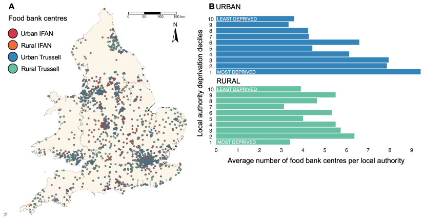
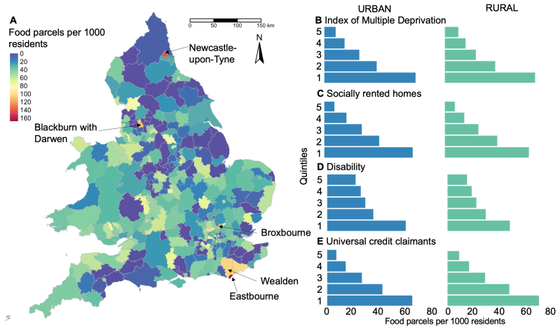
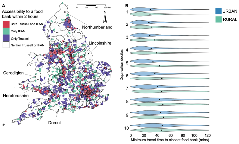
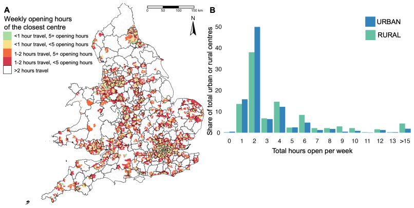
Food bank use in the UK has soared in recent years. The combination of a global pandemic, over-stretched and underfunded public services, and a cost-of-living crisis has meant that millions of people cannot afford basic essentials such as food, heating, housing, and baby supplies. Food bank use is driven by a complex range of factors, including poverty, health emergencies, income shocks, delays to universal credit payments, housing issues, and homelessness. In this study we identify an urban-rural divide in spatial accessibility to food banks. In cities, food banks tend to be highly accessible by public transport to deprived populations but, on average, have shorter opening hours. In rural areas, however, despite generally longer opening hours, food banks are typically not highly accessible except for the most deprived residents. This matters. We find that spatial accessibility to a Trussell food bank centre is a key predictor of food parcel uptake, with a significantly stronger relationship than factors emphasised in the literature such as disability and Universal Credit. Importantly, this relationship is markedly stronger for rural populations, suggesting an unmet need in deprived rural areas far from food banks. Our work has important implications for food bank policy, suggesting a need for improved public transport in rural areas, and optimising current food bank locations and delivery models.
Editorial analysis
A structured set of objections, weighed in public.
Referee Report
Summary. The manuscript identifies an urban-rural divide in spatial accessibility to Trussell food bank centres in England and Wales: urban centres are typically highly accessible by public transport to deprived populations but have shorter opening hours, while rural centres have longer opening hours but lower accessibility except for the most deprived residents. It claims that spatial accessibility is a key predictor of food parcel uptake, with a significantly stronger relationship than disability or Universal Credit receipt, and that this relationship is markedly stronger for rural populations, implying unmet need and policy needs for rural transport and location optimisation.
Significance. If the regression results are robust, the paper would usefully extend the literature on food bank use by quantifying spatial barriers and documenting a rural-urban heterogeneity that is not explained by factors already emphasised in prior work. The spatial accessibility framing and policy implications for transport and delivery models are relevant to applied economics and public policy.
major comments (2)
- [Abstract] Abstract: the central claim that spatial accessibility 'is a key predictor of food parcel uptake, with a significantly stronger relationship than factors emphasised in the literature such as disability and Universal Credit' cannot be evaluated because the abstract (and the provided text) supplies no information on data sources, the regression specification, included controls, fixed effects, or robustness checks for confounding.
- [Abstract] Abstract/Results: the claim that the accessibility-uptake relationship 'is markedly stronger for rural populations' is load-bearing for the paper's main contribution, yet no detail is given on how rural-urban heterogeneity was tested (e.g., interaction terms, stratified models, or tests for differential measurement error), leaving open whether the difference reflects a true barrier or differences in data coverage, need, or siting between urban and rural areas.
Simulated Author's Rebuttal
We thank the referee for their constructive comments on our manuscript. We address each major comment below. Where the comments correctly identify gaps in the abstract, we will revise the manuscript to improve clarity and evaluability of the claims while preserving the core analysis and findings.
read point-by-point responses
-
Referee: [Abstract] Abstract: the central claim that spatial accessibility 'is a key predictor of food parcel uptake, with a significantly stronger relationship than factors emphasised in the literature such as disability and Universal Credit' cannot be evaluated because the abstract (and the provided text) supplies no information on data sources, the regression specification, included controls, fixed effects, or robustness checks for confounding.
Authors: We agree that the abstract as currently written does not supply sufficient methodological detail for readers to evaluate the central claim. The full manuscript contains the underlying data sources (Trussell Trust food parcel uptake records linked to spatial accessibility metrics derived from public transport timetables and deprivation indices from the English and Welsh Indices of Multiple Deprivation), the regression specification (linear models of uptake on accessibility with controls for disability rates, Universal Credit receipt, local deprivation, and region fixed effects), and robustness checks (alternative specifications, checks for multicollinearity, and sensitivity to measurement error). We will revise the abstract to concisely incorporate these elements so that the claim can be evaluated on its face. revision: yes
-
Referee: [Abstract] Abstract/Results: the claim that the accessibility-uptake relationship 'is markedly stronger for rural populations' is load-bearing for the paper's main contribution, yet no detail is given on how rural-urban heterogeneity was tested (e.g., interaction terms, stratified models, or tests for differential measurement error), leaving open whether the difference reflects a true barrier or differences in data coverage, need, or siting between urban and rural areas.
Authors: We accept that the abstract provides no information on the heterogeneity test. In the manuscript we implemented the test via both an interaction term between the accessibility measure and a binary rural indicator (based on the ONS urban-rural classification) and via fully stratified regressions; we also examined whether differential siting or data coverage could explain the pattern by comparing accessibility distributions and uptake reporting rates across urban and rural LSOAs. We will add a brief description of this approach to the abstract and expand the methods section to include explicit discussion of potential differential measurement error and robustness to alternative rural definitions. revision: yes
Circularity Check
No significant circularity in empirical observational study
full rationale
This is a standard empirical paper reporting statistical associations from observational data on spatial accessibility and food parcel uptake rates. No derivation chain, equations, or first-principles results are presented that reduce to fitted inputs by construction. The central claim is an empirical finding from regression-style analysis (accessibility as predictor), not a self-referential definition or renamed known result. No load-bearing self-citations, uniqueness theorems, or ansatz smuggling are indicated in the abstract or described structure. The analysis is self-contained against external benchmarks as a data-driven observational study.
Axiom & Free-Parameter Ledger
axioms (1)
- domain assumption Standard regression assumptions hold, including no major omitted variable bias in the accessibility-uptake model.
Reference graph
Works this paper leans on
-
[1]
Allen and S
J. Allen and S. Farber. Changes in transit accessibility to food banks in toronto during covid-19. Findings, page 24072, 2021
2021
-
[2]
Berg and J
J. Berg and J. Ihlstr \"o m. The importance of public transport for mobility and everyday activities among rural residents. Social Sciences, 8 0 (2): 0 58, 2019
2019
-
[3]
Bramley, M
G. Bramley, M. Treanor, F. Sosenko, and M. Littlewood. State of hunger: Building the evidence on poverty, destitution, and food insecurity in the uk, 2021. URL https://www.trusselltrust.org/wp-content/uploads/sites/2/2022/04/EOY-Stats-2022-Data-Briefing.pdf
2021
-
[4]
R. Bull, C. Miles, E. Newbury, A. Nichols, T. Weekes, and G. Wyld. Hunger in the uk. Technical report, Trussell Trust Network, 2023. URL https://www.trusselltrust.org/wp-content/uploads/sites/2/2023/08/2023-The-Trussell-Trust-Hunger-in-the-UK-report-web-updated-10Aug23.pdf
2023
-
[5]
Chen and P
X. Chen and P. Jia. A comparative analysis of accessibility measures by the two-step floating catchment area (2sfca) method. International Journal of Geographical Information Science, 33 0 (9): 0 1739--1758, 2019
2019
-
[6]
Stat-xplore, 2024
Department for Work and Pensions . Stat-xplore, 2024. URL https://stat-xplore.dwp.gov.uk/
2024
-
[7]
Dijkstra, H
L. Dijkstra, H. Poelman, and P. Veneri. The eu-oecd definition of a functional urban area. OECD Regional Development Working Papers, 2019 0 (11), 2019
2019
-
[8]
Francis-Devine
B. Francis-Devine. Who is experiencing food insecurity in the uk?, 2024. URL https://commonslibrary.parliament.uk/who-is-experiencing-food-insecurity-in-the-uk/
2024
-
[9]
S. Hegerty. Commercial bank locations and “banking deserts”: a statistical analysis of milwaukee and buffalo. Annals of Regional Science, 56: 0 253–271, 2016. URL https://doi.org/10.1007/s00168-015-0736-3
-
[10]
Our members, 2024
IFAN . Our members, 2024. URL https://www.foodaidnetwork.org.uk/our-members
2024
-
[11]
H. Lambie-Mumford. The growth of food banks in britain and what they mean for social policy. Critical Social Policy, 39: 0 3--22, 2019. URL https://doi.org/10.1177/0261018318765855
-
[12]
Loopstra, H
R. Loopstra, H. Lambie-Mumford, and J. Fledderjohann. Food bank operational characteristics and rates of food bank use across britain. BMC Public Health, 19 0 (1): 0 1--10, 2019
2019
-
[13]
Macdonald, P
L. Macdonald, P. McCrorie, N. Nicholls, and A. Ellaway. Walkability around primary schools and area deprivation across scotland. BMC public health, 16: 0 1--7, 2016
2016
-
[14]
Macintyre, L
S. Macintyre, L. Macdonald, and A. Ellaway. Do poorer people have poorer access to local resources and facilities? the distribution of local resources by area deprivation in glasgow, scotland. Social science & medicine, 67 0 (6): 0 900--914, 2008
2008
-
[15]
M. MacLeod, A. Curl, and A. Kearns. Understanding the prevalence and drivers of food bank use: Evidence from deprived communities in glasgow. Social Policy and Society, 18: 0 1--20, 2018. doi:10.1017/S1474746418000064
-
[16]
Marascuilo
L. Marascuilo. Statistical methods for the social and behavioral sciences. WH Freeman and Co, 1988
1988
-
[17]
M. Mears, P. Brindley, R. Maheswaran, and A. Jorgensen. Understanding the socioeconomic equity of publicly accessible greenspace distribution: The example of sheffield, uk. Geoforum, 103, 2019. doi:10.1016/j.geoforum.2019.04.016
-
[18]
Statistical geographies: An overview of the statistical geographies in the four countries of the uk, 2020
Office for National Statistics . Statistical geographies: An overview of the statistical geographies in the four countries of the uk, 2020. URL https://www.ons.gov.uk/methodology/geography/ukgeographies/statisticalgeographies
2020
-
[19]
L. Oldroyd, F. Eskandari, C. Pratt, and A. Lake. The nutritional quality of food parcels provided by food banks and the effectiveness of food banks at reducing food insecurity in developed countries: a mixed-method systematic review. Journal of Human Nutrition and Dietetics, 35: 0 1202–1229, 2022. URL https://doi.org/10.1111/jhn.12994
-
[20]
Open geography portal, 2024
ONS . Open geography portal, 2024. URL https://geoportal.statistics.gov.uk
2024
-
[21]
R. H. M. Pereira, M. Saraiva, D. Herszenhut, C. K. V. Braga, and M. W. Conway. r5r: Rapid realistic routing on multimodal transport networks with r5 in r. Findings, 2021. doi:10.32866/001c.21262. URL https://doi.org/10.32866/001c.21262
-
[22]
E. Prayogo, A. Chater, S. Chapman, M. Barker, A. Rahmawati, T. Waterfall, and G. Grimble. Who uses foodbanks and why? exploring the impact of financial strain and adverse life events on food insecurity. Journal of Public Health, 40: 0 676 -- 683, 2018. doi:https://doi.org/10.1093/pubmed/fdx133
-
[23]
A. Reeves and R. Loopstra. The continuing effects of welfare reform on food bank use in the uk: The roll-out of universal credit. Journal of Social Policy, 50: 0 788--808, 2021. doi:10.1017/S0047279420000513
-
[24]
M. Safayet, J. P. C. Connors, and M. Watson. Measuring access to food banks and food pantries: A scoping review of spatial analysis approaches. Health and Place, 88, 2024. URL https://doi.org/10.1016/j.healthplace.2024.103251
-
[25]
A. Simmet, N. Stroebele-Benschop, and P. Tinnemann. Area characteristics associated with food pantry use in berlin – a cross-sectional ecological study. Applied Geography, 89: 0 87--99, 2017. doi:10.1016/j.apgeog.2017.10.005
-
[26]
M. L. Small, A. Akhavan, M. Torres, and Q. Wang. Banks, alternative institutions and the spatial--temporal ecology of racial inequality in us cities. Nature Human Behaviour, 5 0 (12): 0 1622--1628, 2021
2021
-
[27]
D. M. Smith, S. Cummins, M. Taylor, J. Dawson, D. Marshall, L. Sparks, and A. S. Anderson. Neighbourhood food environment and area deprivation: spatial accessibility to grocery stores selling fresh fruit and vegetables in urban and rural settings. International Journal of Epidemiology, 39: 0 277--284, 2010. doi:https://doi.org/10.1093/ije/dyp221
-
[28]
Sosenko, G
F. Sosenko, G. Bramley, and A. Bhattacharjee. Understanding the post-2010 increase in food bank use in england: new quasi-experimental analysis of the role of welfare policy. BMC public health, 22 0 (1): 0 1--10, 2022
2010
-
[29]
Y. Sun and P. V. Thakuriah. Public transport availability inequalities and transport poverty risk across england. Environment and Planning B: Urban Analytics and City Science, 48: 0 2775--2789, 2021. URL https://doi.org/10.1177/2399808321991536
-
[30]
Food insecurity tracking, 2024
The Food Foundation . Food insecurity tracking, 2024. URL https://foodfoundation.org.uk/initiatives/food-insecurity-tracking#tabs/Round-15
2024
-
[31]
A. Todd, A. Copeland, A. Husband, A. Kasim, and C. Bambra. Access all areas? an area-level analysis of accessibility to general practice and community pharmacy services in england by urbanity and social deprivation. BMJ Open, 5, 2015. doi:10.1136/bmjopen-2014-007328
-
[32]
Emergency food parcel distribution in the uk 1 april 2023 to 31 march 2024, 2024
Trussell Trust Network . Emergency food parcel distribution in the uk 1 april 2023 to 31 march 2024, 2024. URL https://www.trusselltrust.org/wp-content/uploads/sites/2/2024/05/EYS-UK-Factsheet-2023-24.pdf
2023
-
[33]
C. Trust. Carers trust research reveals unpaid family carers experiencing unprecedented financial hardship with many now using food banks, 2022. URL https://carers.org/news-and-media/news/post/219-carers-trust-research-reveals-unpaid-family-carers-experiencing-unprecedented-financial-hardship-with-many-now-using-food-banks
2022
-
[34]
D. Wainwright, A. Buckingham, and E. Wainwright. Why do people use food banks? a qualitative study of food bank users in an english city. Voluntary Sector Review, 9: 0 311 -- 329, 2018. doi:https://doi.org/10.1332/204080518X15428930047072
-
[35]
R. E. Walker, C. R. Keane, and J. G. Burke. Disparities and access to healthy food in the united states: A review of food deserts literature. Health & place, 16 0 (5): 0 876--884, 2010
2010
-
[36]
Walter and H
S. Walter and H. Tiemeier. Variable selection: current practice in epidemiological studies. European Journal of Epidemiology, 24: 0 733--736, 2009
2009
-
[37]
K. Zaidi. Food banks in the uk. Technical report, House of Commons Library, 2025. URL https://researchbriefings.files.parliament.uk/documents/CBP-8585/CBP-8585.pdf
2025
discussion (0)
Sign in with ORCID, Apple, or X to comment. Anyone can read and Pith papers without signing in.