High Resolution Sediment-Specific Surface Soil Moisture Retrieval Using Sentinel-1 Time Series and Auxiliary Data
Pith reviewed 2026-06-25 22:27 UTC · model grok-4.3
The pith
Sediment-specific models using Sentinel-1 time series and auxiliary data retrieve surface soil moisture with RMSE of 0.037-0.050 m³/m³ and R² up to 0.90.
A machine-rendered reading of the paper's core claim, the machinery that carries it, and where it could break.
Core claim
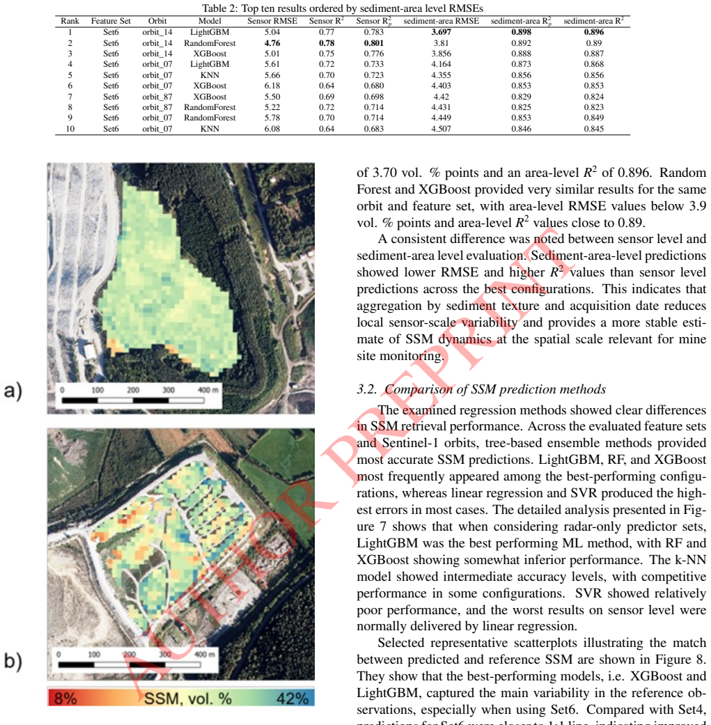
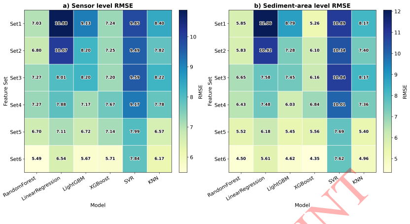
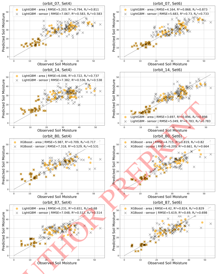
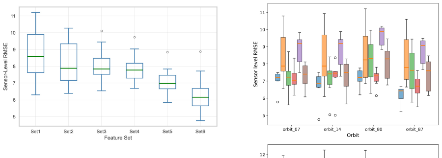
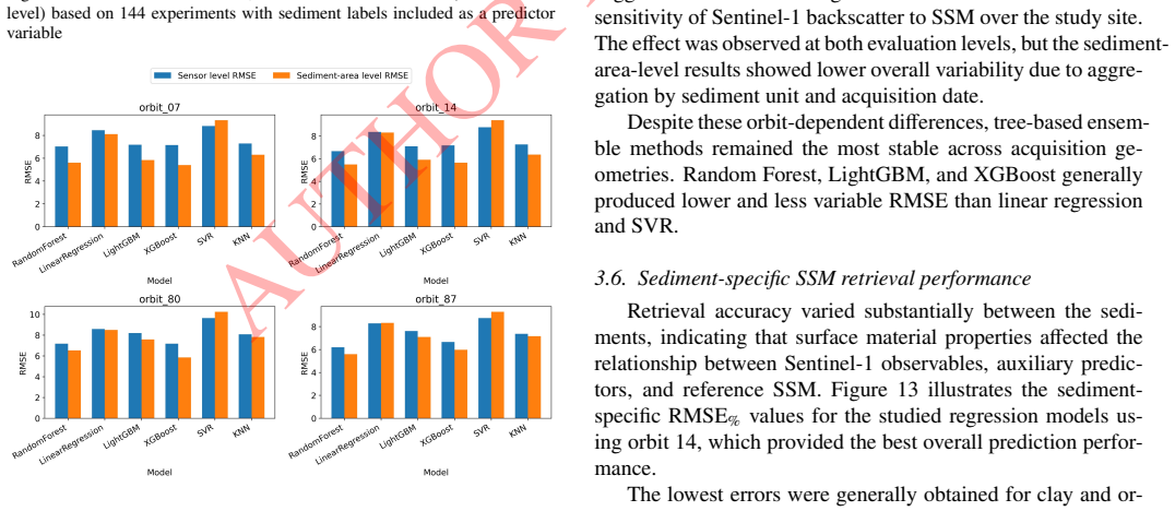
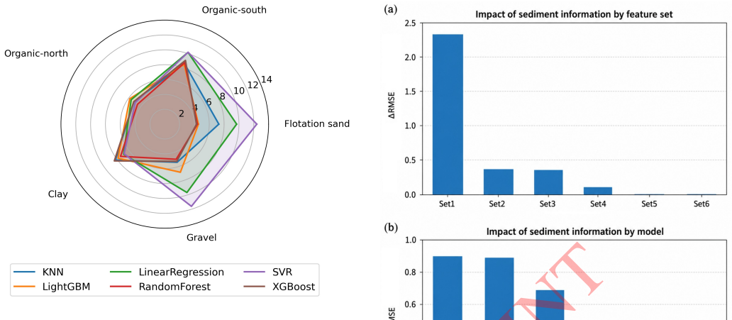
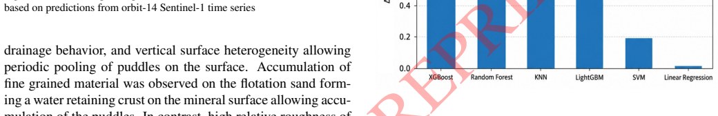
The authors establish that sediment-specific well-calibrated machine learning models, using the most comprehensive feature set of Sentinel-1 backscatter and time-series soil moisture indices along with Sentinel-2 optical, topographic and temperature predictors, produce spatially explicit high-resolution soil moisture estimates. In the best configurations, RMSE reaches 0.037-0.050 m³ m⁻³ with R² up to 0.90, and tree-based ensembles like LightGBM, random forest and XGBoost give the most accurate and stable results. Adding sediment type information improves basic Sentinel-1 retrievals by more than 2 volumetric percent but adds little when richer features are already included. Performance varies
What carries the argument
Sediment-specific machine learning regression models trained on multi-source remote sensing features and in-situ capacitance sensor data.
If this is right
- Tree-based ensemble methods yield the most accurate and stable soil moisture predictions across conditions.
- Comprehensive feature sets that include time-series indices and auxiliary data outperform Sentinel-1 backscatter alone.
- Sediment type information provides notable gains mainly for simpler Sentinel-1-only retrievals.
- Retrieval accuracy differs across sediment types, remaining lowest for clay and organic soils.
Where Pith is reading between the lines
- The method could be tested at other mining or construction sites that share similar sediment variability, provided local calibration data exist.
- High-resolution maps produced this way could support real-time decisions on dust control or drainage at active quarries.
- Extending the temporal coverage or adding further sensor inputs might reduce errors further for the harder-to-predict sediments such as gravel.
Load-bearing premise
The in-situ reference observations from capacitance sensors accurately represent the true soil moisture for each sediment type under varying weather conditions at the study site.
What would settle it
Independent validation measurements at the same site or a similar mining location that produce RMSE values consistently above 0.06 m³/m³ for the same feature sets and methods would challenge the reported accuracy.
Figures

read the original abstract
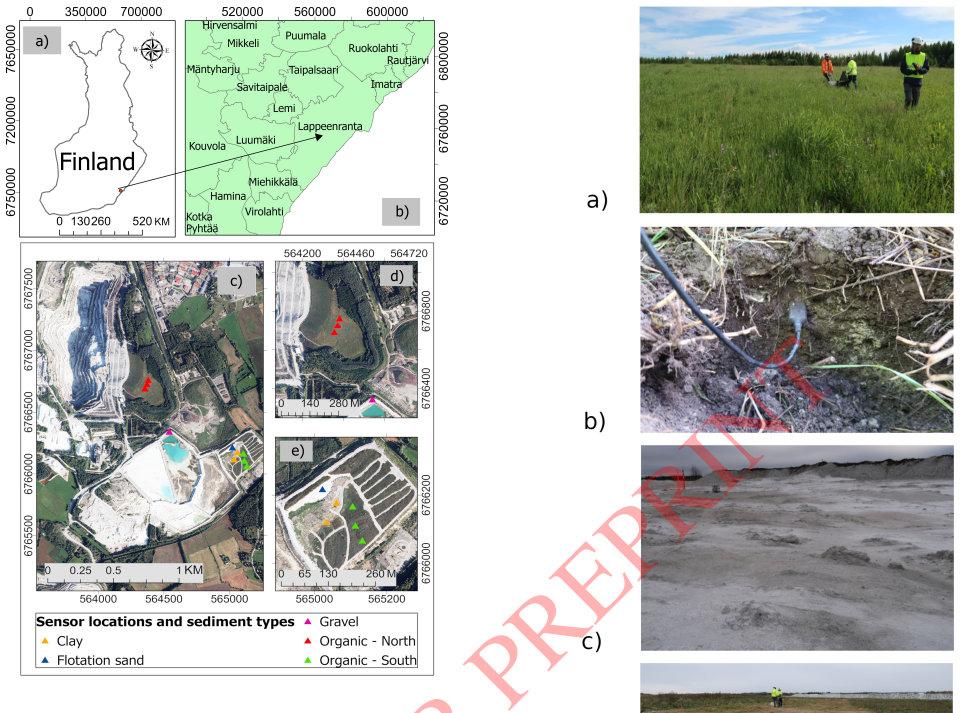
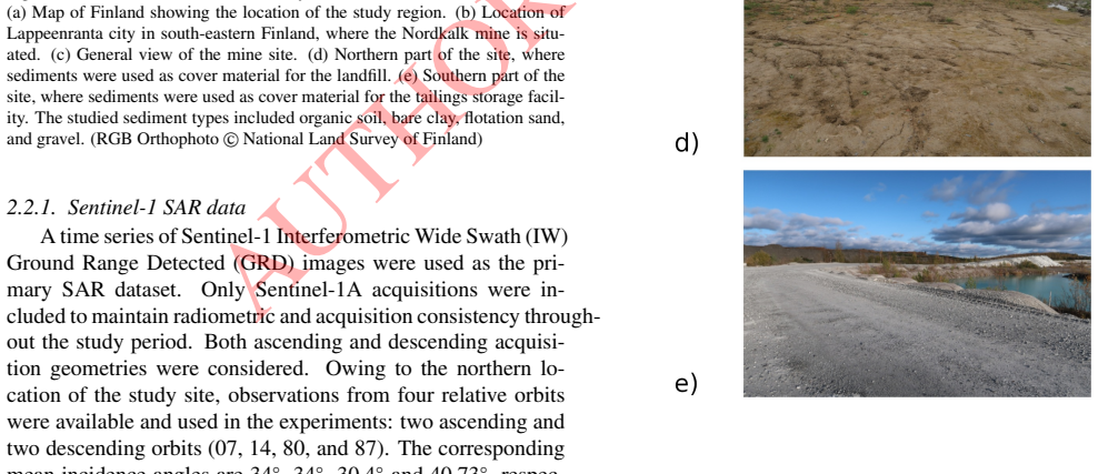
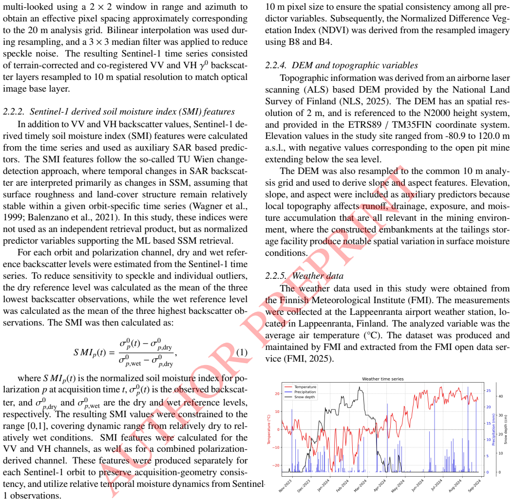
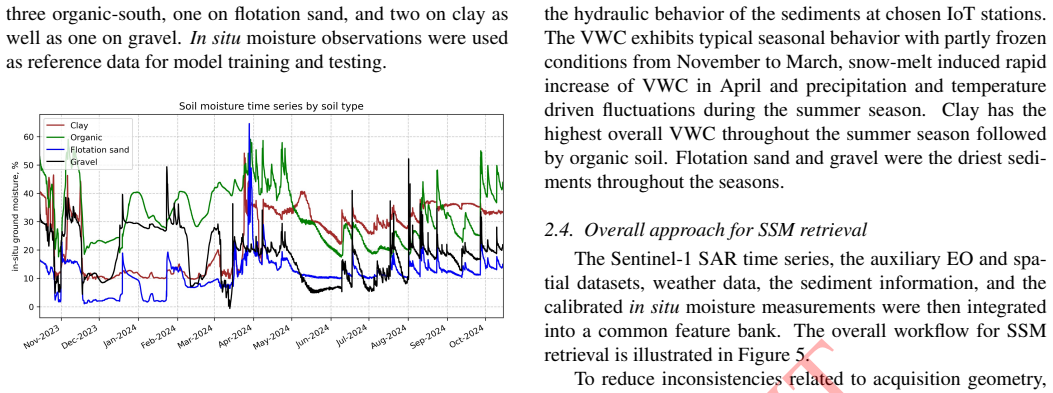
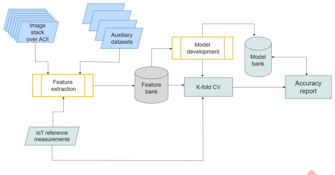
In this study, we examine the potential of continuous ground moisture monitoring over a mining site using a combination of in-situ soil moisture sensors and multi-sensor SAR images. We focus on assessing and improving methodologies for retrieval of surface soil moisture, i.e. ground moisture, from SAR measurements focusing on detailed in situ reference observations for several key geomaterials, i.e. sediments, typical in the study site. The mining site represents a limestone quarry locate in the southeastern Finland. Our hypothesis is that sediment-specific well-calibrated models can be instrumental in improving soil moisture retrieval under different weather conditions to produce spatially explicit soil moisture estimates at high resolution compared to baseline approaches. Studied SAR data are represented by Copernicus Sentinel-1 C-band images, while auxiliary datasets include optical Sentinel-2 data. Reference data were collected using IoT enabled capacitance sensors. The examined machine learning methods include Xgboost, LightGBM, RFs, linear regression and k-nearest neighbors regression. The best performance was achieved with the most comprehensive feature set which combines Sentinel-1 backscatter, time-series based soil moisture indices, Sentinel-2 optical, topographic, and temperature predictors. In the best sediment-area-level configurations, RMSE decreased to 0.037-0.050 m^3 m^(-3) (3.7-5.0 volumetric % points), with R^2 values reaching 0.90. Tree-based ensemble methods, especially LightGBM, RF, and XGBoost, provided the most accurate and stable predictions. Accuracy varied by sediment texture, with the lowest errors for clay and organic soil and higher errors for flotation sand and gravel. Adding sediment information improved Sentinel-1-only retrievals by more than 2 vol-%, but provided little additional benefit when richer multi-source feature sets were used.
Editorial analysis
A structured set of objections, weighed in public.
Referee Report
Summary. The manuscript claims that sediment-specific machine learning models trained on Sentinel-1 C-band SAR time series, augmented with Sentinel-2 optical indices, topographic, and temperature predictors, can retrieve surface soil moisture at high resolution over a Finnish limestone quarry. Using IoT capacitance sensors as reference, it reports that tree-based ensembles (LightGBM, RF, XGBoost) achieve RMSE of 0.037-0.050 m³ m⁻³ and R² up to 0.90 in the best sediment-area configurations, with sediment information improving Sentinel-1-only retrievals by >2 vol-% and accuracy varying by texture (lowest errors on clay/organic, higher on sand/gravel).
Significance. If the reference observations are reliable, the work offers a practical demonstration of how multi-source features and sediment stratification can enhance SAR-based soil moisture retrieval in heterogeneous mining environments. The empirical comparison across five ML methods and multiple feature sets, plus the reported gains from time-series indices, would be a useful contribution to operational monitoring applications.
major comments (2)
- [Abstract and §3] Abstract and §3 (Methods/Validation): All reported metrics (RMSE 0.037-0.050 m³ m⁻³, R²=0.90) are computed directly against the IoT capacitance sensor readings used as ground truth, yet the text supplies no per-sediment calibration curves, laboratory dielectric measurements, gravimetric cross-checks, or independent validation of the sensors across clay, organic, sand, and gravel materials. Capacitance probes are known to require texture-specific calibration because of sensitivity to bulk density, salinity, and organic content; without this, the sediment-specific improvement claim and headline accuracy figures rest on an untested assumption that the sensors faithfully track true volumetric moisture.
- [§4] §4 (Results): The claim that 'adding sediment information improved Sentinel-1-only retrievals by more than 2 vol-%' is presented without error bars, statistical significance tests, or cross-validation details that would confirm the improvement is not an artifact of post-hoc model selection or data leakage between training and test periods.
minor comments (2)
- [Abstract and §2] The abstract and methods section should explicitly state the number of sensors per sediment class, the temporal overlap between SAR acquisitions and sensor readings, and any temporal filtering applied to the time series.
- [Abstract] Notation for volumetric moisture (m³ m⁻³) is used inconsistently with the parenthetical 'volumetric % points'; standardize throughout.
Simulated Author's Rebuttal
We thank the referee for the constructive comments on our manuscript. We address each major point below and indicate where revisions will be made to improve clarity and rigor.
read point-by-point responses
-
Referee: [Abstract and §3] Abstract and §3 (Methods/Validation): All reported metrics (RMSE 0.037-0.050 m³ m⁻³, R²=0.90) are computed directly against the IoT capacitance sensor readings used as ground truth, yet the text supplies no per-sediment calibration curves, laboratory dielectric measurements, gravimetric cross-checks, or independent validation of the sensors across clay, organic, sand, and gravel materials. Capacitance probes are known to require texture-specific calibration because of sensitivity to bulk density, salinity, and organic content; without this, the sediment-specific improvement claim and headline accuracy figures rest on an untested assumption that the sensors faithfully track true volumetric moisture.
Authors: We agree that the manuscript does not present per-sediment laboratory calibrations or gravimetric cross-checks for the capacitance sensors. The sensors were installed and operated according to manufacturer guidelines for volumetric moisture estimation in typical mineral soils, and our analysis treats the readings as the reference for evaluating relative model performance across sediment types. The sediment-specific models are intended to capture texture-related variations in the SAR-auxiliary feature space rather than to correct absolute sensor bias. In revision we will expand §3 to include a dedicated paragraph on sensor limitations, citing the known sensitivity of capacitance probes to texture, bulk density and organic matter, and we will qualify the reported RMSE/R² values as relative to the deployed IoT readings. revision: yes
-
Referee: [§4] §4 (Results): The claim that 'adding sediment information improved Sentinel-1-only retrievals by more than 2 vol-%' is presented without error bars, statistical significance tests, or cross-validation details that would confirm the improvement is not an artifact of post-hoc model selection or data leakage between training and test periods.
Authors: The >2 vol-% improvement was obtained by comparing otherwise identical model configurations (same feature sets, same temporal splits) with and without the sediment class as an additional categorical predictor; the comparison was repeated across the five ML algorithms and multiple random seeds. In the revised manuscript we will (i) report standard deviations across the cross-validation folds, (ii) add paired statistical tests (Wilcoxon signed-rank on per-fold RMSE) to quantify significance of the sediment-information gain, and (iii) provide an explicit description of the temporal blocking used in cross-validation to exclude leakage. These additions will appear in §4 and the supplementary material. revision: yes
Circularity Check
Empirical ML regression on in-situ targets exhibits no circularity
full rationale
The paper trains standard regressors (LightGBM, RF, XGBoost, etc.) on Sentinel-1 backscatter, time-series indices, Sentinel-2 optical, topographic and temperature features, with IoT capacitance sensor readings serving as the explicit target variable. Reported RMSE and R² values are ordinary cross-validation or hold-out errors against those same sensor observations; no equation, ansatz or uniqueness claim reduces the output to the input by construction. No self-citation chains, fitted-parameter renamings or self-definitional steps appear in the described methodology. The derivation is therefore a conventional supervised-learning pipeline whose central performance claims remain independent of the inputs.
Axiom & Free-Parameter Ledger
axioms (1)
- domain assumption SAR backscatter, time-series indices, and auxiliary optical/topographic data relate to surface soil moisture in a way that ML models can learn across sediment types
Reference graph
Works this paper leans on
-
[1]
Hydrology and Earth System Sciences , volume=
Controls on spatial and temporal variability of soil moisture across a heterogeneous boreal forest landscape , author=. Hydrology and Earth System Sciences , volume=. 2025 , publisher=
2025
-
[2]
Performance assessment of factory and field calibrations for electromagnetic sensors in a loam soil , journal =. 2018 , issn =. doi:https://doi.org/10.1016/j.agwat.2017.10.020 , author =
-
[3]
Hydrologic behavior of model slopes with synthetic water repellent soils , journal =. 2017 , issn =. doi:https://doi.org/10.1016/j.jhydrol.2017.09.013 , author =
-
[4]
Advances in soil moisture retrieval from synthetic aperture radar and hydrological applications , journal =. 2013 , issn =. doi:https://doi.org/10.1016/j.jhydrol.2012.10.044 , author =
-
[5]
and Bazzi, H
Baghdadi, N. and Bazzi, H. and El Hajj, M. and Zribi, M. , TITLE =. Remote Sens. , VOLUME =. 2018 , NUMBER =
2018
-
[6]
A Method for Estimating Soil Moisture from ERS Scatterometer and Soil Data , journal =. 1999 , issn =. doi:https://doi.org/10.1016/S0034-4257(99)00036-X , author =
-
[7]
ALOS-2 and Sentinel-1 SAR data sensitivity analysis to surface soil moisture over bare and vegetated agricultural fields , journal =. 2020 , issn =. doi:https://doi.org/10.1016/j.compag.2020.105303 , author =
-
[8]
Sentinel-1 soil moisture at 1 km resolution: a validation study , journal =. 2021 , issn =. doi:https://doi.org/10.1016/j.rse.2021.112554 , author =
-
[9]
, journal=
Small, D. , journal=. Flattening Gamma: Radiometric Terrain Correction for SAR Imagery , year=
-
[10]
1-km soil moisture retrieval using multi-temporal dual-channel. Remote Sens. Env. , volume =. 2023 , issn =. doi:https://doi.org/10.1016/j.rse.2022.113334 , author =
-
[11]
and Jagdhuber, T
Hajnsek, I. and Jagdhuber, T. and Schon, H. and Papathanassiou, K.P. , journal=. Potential of Estimating Soil Moisture Under Vegetation Cover by Means of PolSAR , year=
-
[12]
Geological Survey of Finland , title =
-
[13]
and Dwyer, Edward and Whelan, Pádraig , TITLE =
Barrett, Brian W. and Dwyer, Edward and Whelan, Pádraig , TITLE =. Remote Sens. , VOLUME =. 2009 , NUMBER =
2009
-
[14]
Soil moisture retrieval over agricultural fields from L-band multi-incidence and multitemporal PolSAR observations using polarimetric decomposition techniques , journal =. 2021 , issn =. doi:https://doi.org/10.1016/j.rse.2021.112485 , author =
-
[15]
and Parizzi, A
De Zan, F. and Parizzi, A. and Prats-Iraola, P. and López-Dekker, P. , journal=. A. 2014 , volume=
2014
-
[16]
and Hajnsek, I
Jagdhuber, T. and Hajnsek, I. and Papathanassiou, K. P. , journal=. An Iterative Generalized Hybrid Decomposition for Soil Moisture Retrieval Under Vegetation Cover Using Fully Polarimetric. 2015 , volume=
2015
-
[17]
Das and Dara Entekhabi and Rowena Lohman and Andreas Colliander and Dharmendra Kumar Pandey and R.K
Preet Lal and Gurjeet Singh and Narendra N. Das and Dara Entekhabi and Rowena Lohman and Andreas Colliander and Dharmendra Kumar Pandey and R.K. Setia , keywords =. A multi-scale algorithm for the NISAR mission high-resolution soil moisture product , journal =. 2023 , issn =
2023
-
[18]
Baldwin and S
D. Baldwin and S. Manfreda and K. Keller and E.A.H. Smithwick , keywords =. Predicting root zone soil moisture with soil properties and satellite near-surface moisture data across the conterminous United States , journal =. 2017 , issn =
2017
-
[19]
Hydrology Research , volume=
Operational readiness of microwave remote sensing of soil moisture for hydrologic applications , author=. Hydrology Research , volume=. 2007 , publisher=
2007
-
[20]
and Batlivala, Percy P
Ulaby, Fawwaz T. and Batlivala, Percy P. and Dobson, Myron C. , journal=. Microwave Backscatter Dependence on Surface Roughness, Soil Moisture, and Soil Texture: Part I-Bare Soil , year=
-
[21]
Machine learning , volume=
Random forests , author=. Machine learning , volume=. 2001 , publisher=
2001
-
[22]
Science of Remote Sensing , volume=
Surface soil moisture prediction using multimodal remote sensing data fusion and machine learning algorithms in semi-arid agricultural region , author=. Science of Remote Sensing , volume=. 2025 , publisher=
2025
-
[23]
Sensors , volume=
Synergetic use of Sentinel-1 and Sentinel-2 data for soil moisture mapping at 100 m resolution , author=. Sensors , volume=. 2017 , publisher=
2017
-
[24]
Advances in Space Research , volume=
Comparison of three machine learning algorithms for retrieving soil moisture information from Sentinel-1A SAR data in northwest Shandong plain, China , author=. Advances in Space Research , volume=. 2024 , publisher=
2024
-
[25]
Statistics and Computing , year=
A tutorial on support vector regression , author=. Statistics and Computing , year=
-
[26]
Gleason and Jungho Im , keywords =
Colin J. Gleason and Jungho Im , keywords =. Forest biomass estimation from airborne LiDAR data using machine learning approaches , journal =. 2012 , issn =. doi:https://doi.org/10.1016/j.rse.2012.07.006 , url =
-
[27]
Tibshirani ,\ 10.1111/j.2517-6161.1996.tb02080.x journal journal J
Tibshirani, Robert , title =. Journal of the Royal Statistical Society: Series B (Methodological) , volume =. 2018 , month =. doi:10.1111/j.2517-6161.1996.tb02080.x , url =
-
[28]
ESA Living Planet Symposium , year = 2010, editor =
Terrain-Corrected Gamma: Improved Thematic Land-Cover Retrieval for SAR with Robust Radiometric Terrain Correction. ESA Living Planet Symposium , year = 2010, editor =
2010
-
[29]
Machine Learning , year=
Support-Vector Networks , author=. Machine Learning , year=
-
[30]
and Smola, Alex , title =
Vapnik, Vladimir and Golowich, Steven E. and Smola, Alex , title =. Proceedings of the 10th International Conference on Neural Information Processing Systems , pages =. 1996 , publisher =
1996
-
[31]
The Support Vector Method of Function Estimation
Vapnik, Vladimir. The Support Vector Method of Function Estimation. Nonlinear Modeling: Advanced Black-Box Techniques. 1998. doi:10.1007/978-1-4615-5703-6_3
-
[32]
Steve R. Gunn. Support Vector Machines for Classification and Regression. 1998
1998
-
[33]
and Ulander, Lars M
Neumann, Maxim and Saatchi, Sassan S. and Ulander, Lars M. H. and Fransson, Johan E. S. , journal=. Assessing Performance of L- and P-Band Polarimetric Interferometric SAR Data in Estimating Boreal Forest Above-Ground Biomass , year=
-
[34]
Modeling Aboveground Biomass in Tropical Forests Using Multi-Frequency SAR Data—A Comparison of Methods , year=
Englhart, Sandra and Keuck, Vanessa and Siegert, Florian , journal=. Modeling Aboveground Biomass in Tropical Forests Using Multi-Frequency SAR Data—A Comparison of Methods , year=
-
[35]
European Journal of Remote Sensing , volume =
Ayoob Karami and Nicolas Baghdadi and Henri Bazzi and Yasser Nasrallah and Mehrez Zribi and Sami Najem and Jean-Pierre Wigneron , title =. European Journal of Remote Sensing , volume =. 2026 , publisher =
2026
-
[36]
, TITLE =
Lamichhane, Manoj and Mehan, Sushant and Mankin, Kyle R. , TITLE =. Remote Sensing , VOLUME =. 2025 , NUMBER =
2025
-
[37]
Li, Xiang and Nieber, John L. and Kumar, Vipin , title =. Vadose Zone Journal , volume =. doi:https://doi.org/10.1002/vzj2.20361 , year =
-
[38]
Model-based Tensor Decompositions for Geophysical Parameter Retrieval from Multidimensional SAR Data , year=
Basargin, Nikita and Alonso-González, Alberto and Hajnsek, Irena , journal=. Model-based Tensor Decompositions for Geophysical Parameter Retrieval from Multidimensional SAR Data , year=
-
[39]
, journal=
Zhu, Liujun and Dai, Junjie and Jin, Junliang and Yuan, Shanshui and Xiong, Ziwei and Walker, Jeffrey P. , journal=. Are the Current Expectations for SAR Remote Sensing of Soil Moisture Using Machine Learning Overoptimistic? , year=
-
[40]
Sensors , volume=
Retrieval of surface soil moisture at field scale using Sentinel-1 SAR data , author=. Sensors , volume=. 2025 , publisher=
2025
-
[41]
IGARSS 2025-2025 IEEE International Geoscience and Remote Sensing Symposium , pages=
Field-scale soil moisture estimated from Sentinel-1 SAR data using a knowledge-guided deep learning approach , author=. IGARSS 2025-2025 IEEE International Geoscience and Remote Sensing Symposium , pages=. 2025 , organization=
2025
-
[42]
Vadose Zone Journal , volume=
From point to pixel scale: An upscaling approach for in situ soil moisture measurements , author=. Vadose Zone Journal , volume=. 2016 , publisher=
2016
-
[43]
2026 , doi =
Lems, Johanna and Dorigo, Wouter and Gruber, Alexander , title =. 2026 , doi =
2026
-
[44]
Remote Sensing , volume=
High spatial and temporal soil moisture retrieval in agricultural areas using multi-orbit and vegetation adapted Sentinel-1 SAR time series , author=. Remote Sensing , volume=. 2023 , publisher=
2023
-
[45]
IEEE Transactions on Geoscience and Remote Sensing , volume=
Sentinel-1 sensitivity to soil moisture at high incidence angle and the impact on retrieval over seasonal crops , author=. IEEE Transactions on Geoscience and Remote Sensing , volume=. 2020 , publisher=
2020
-
[46]
Advances in neural information processing systems , volume=
Lightgbm: A highly efficient gradient boosting decision tree , author=. Advances in neural information processing systems , volume=
-
[47]
Proceedings of the 22nd acm sigkdd international conference on knowledge discovery and data mining , pages=
Xgboost: A scalable tree boosting system , author=. Proceedings of the 22nd acm sigkdd international conference on knowledge discovery and data mining , pages=
-
[48]
Journal of the Indian Society of Remote Sensing , volume=
Estimation of surface moisture content using Sentinel-1 C-band SAR data through machine learning models , author=. Journal of the Indian Society of Remote Sensing , volume=. 2021 , publisher=
2021
-
[49]
Land , volume=
Comparative analysis of machine-learning models for soil moisture estimation using high-resolution remote-sensing data , author=. Land , volume=. 2024 , publisher=
2024
-
[50]
the Journal of machine Learning research , volume=
Scikit-learn: Machine learning in Python , author=. the Journal of machine Learning research , volume=. 2011 , publisher=
2011
-
[51]
Remote Sensing , volume=
The Influence of Texture on Soil Moisture Modeling for Soils of Diverse Roughness Using Backscattering Coefficient and Polarimetric Decompositions Derived from Sentinel-1 Data , author=. Remote Sensing , volume=. 2025 , publisher=
2025
-
[52]
Remote Sensing , volume=
Soil texture, soil moisture, and Sentinel-1 backscattering: Towards the retrieval of field-scale soil hydrological properties , author=. Remote Sensing , volume=. 2025 , publisher=
2025
-
[53]
Sentinel-1 Next Generation: Enhanced C-band Data Continuity , year=
Torres, Ramon and Geudtner, Dirk and Davidson, Malcolm and Bibby, David and Navas-Traver, Ignacio and Garcia Hernandez, Ana Isabel and Laduree, Gregory and Poupaert, Jelle and Cossu, Mario and Touveneau, Marie and Graham, Stefan , booktitle=. Sentinel-1 Next Generation: Enhanced C-band Data Continuity , year=
-
[54]
GMES Sentinel-1 mission , journal =. 2012 , note =. doi:https://doi.org/10.1016/j.rse.2011.05.028 , author =
-
[55]
and Bawden, Gerald W
Rosen, Paul A. and Bawden, Gerald W. and Barela, Phil and Chapman, Bruce and Fattahi, Heresh and Jones, Cathleen E. and Joughin, Ian R. and Lavalle, Marco and Lohman, Rowena B. and Simons, Mark and Siqueira, Paul and Das, Anup and Desai, Nilesh M. and Kumar, Raj and Putrevu, Deepak and Sharma, Rashmi and Shrikant, CV , journal=. The NASA-ISRO SAR Mission:...
-
[56]
Soil moisture retrieval from remote sensing measurements: Current knowledge and directions for the future , journal =. 2021 , issn =. doi:https://doi.org/10.1016/j.earscirev.2021.103673 , author =
-
[57]
Mohammad Amin Shahriari and Hossein Aghighi and Mohsen Azadbakht and Davoud Ashourloo and Ali Akbar Matkan and Foad Brakhasi and Jeffrey P. Walker , keywords =. Soil moisture estimation using combined SAR and optical imagery: Application of seasonal machine learning algorithms , journal =. 2025 , issn =. doi:https://doi.org/10.1016/j.asr.2025.01.064 , url =
-
[58]
The Extractive Industries and Society , volume=
The role of earth observation technologies in enhancing social acceptance of mining operations , author=. The Extractive Industries and Society , volume=. 2025 , publisher=
2025
-
[59]
Remote Sensing of Environment , volume =
Soil moisture retrieval from Sentinel-1: Lessons learned after more than a decade in orbit , author =. Remote Sensing of Environment , volume =. 2026 , doi =
2026
-
[60]
and Dasgupta, Antara and Rahmati, Mehdi and Jagdhuber, Thomas , journal =
Montzka, Carsten and Brocca, Luca and Chen, Hao and Das, Narendra N. and Dasgupta, Antara and Rahmati, Mehdi and Jagdhuber, Thomas , journal =. 2026 , doi =
2026
-
[61]
Intercomparison of very high-resolution surface soil moisture products over
Ouaadi, Nadia and Jarlan, Lionel and Le Page, Michel and Zribi, Mehrez and Paolini, Giovani and Ait Hssaine, Bouchra and Escorihuela, Maria Jose and Fanise, Pascal and Merlin, Olivier and Baghdadi, Nicolas and Boone, Aaron , journal =. Intercomparison of very high-resolution surface soil moisture products over. 2024 , doi =
2024
-
[62]
International Journal of Applied Earth Observation and Geoinformation , volume =
High-resolution surface soil moisture retrieval: A hybrid machine learning framework integrating change detection and downscaling for precision water management , author =. International Journal of Applied Earth Observation and Geoinformation , volume =. 2025 , doi =
2025
-
[63]
CATENA , volume =
Comparison of bagging, boosting and stacking algorithms for surface soil moisture mapping using optical-thermal-microwave remote sensing synergies , author =. CATENA , volume =. 2022 , doi =
2022
-
[64]
and Gupta, Dileep Kumar and Kumar, Pradeep and Prasad, Rajendra and Pandey, Dharmendra Kumar and Das, Anup Kumar and Gupta, Manika , journal =
Chaudhary, Sumit Kumar and Srivastava, Prashant K. and Gupta, Dileep Kumar and Kumar, Pradeep and Prasad, Rajendra and Pandey, Dharmendra Kumar and Das, Anup Kumar and Gupta, Manika , journal =. Machine learning algorithms for soil moisture estimation using. 2022 , doi =
2022
-
[65]
Very High Spatial Resolution Soil Moisture Observation of Heterogeneous Subarctic Catchment Using Nonlocal Averaging and Multitemporal
Manninen, Terhikki and J. Very High Spatial Resolution Soil Moisture Observation of Heterogeneous Subarctic Catchment Using Nonlocal Averaging and Multitemporal. IEEE Transactions on Geoscience and Remote Sensing , volume =. 2022 , doi =
2022
-
[66]
Scientific Reports , volume =
Deep learning and data fusion to estimate surface soil moisture from multi-sensor satellite images , author =. Scientific Reports , volume =. 2023 , doi =
2023
-
[67]
Pasolli, L. and Notarnicola, C. and Bruzzone, L. and Bertoldi, G. and Della Chiesa, S. and Hell, V. and Niedrist, G. and Tappeiner, U. and Zebisch, M. and Del Frate, F. and Vaglio Laurin, G. , title =. Applied and Environmental Soil Science , volume =. doi:https://doi.org/10.1155/2011/175473 , url =. https://onlinelibrary.wiley.com/doi/pdf/10.1155/2011/17...
-
[68]
Remote Sensing , VOLUME =
El Hajj, Mohammad and Baghdadi, Nicolas and Zribi, Mehrez and Bazzi, Hassan , TITLE =. Remote Sensing , VOLUME =. 2017 , NUMBER =
2017
discussion (0)
Sign in with ORCID, Apple, or X to comment. Anyone can read and Pith papers without signing in.