REVIEW 3 major objections 5 minor 56 references
GeoBlocks: A Query-Cache Accelerated Data Structure for Spatial Aggregation over Polygons
T0 review · 3 major / 5 minor · reviewed 2026-08-14 · deepseek-v4-flash
Pith's one-line read GeoBlocks pre-aggregates geospatial points into grid cells so aggregate queries over arbitrary polygons run up to three orders of magnitude faster while keeping a user-controlled spatial error bound.
desk verdict A solid systems paper whose 'bounded error' guarantee is geometric, not aggregate-level; the performance work is real, but the abstract overstates the precision guarantee. read the letter →
The pith
A machine-rendered reading of the paper's core claim, the machinery that carries it, and where it could break.
The reading
What carries the argument
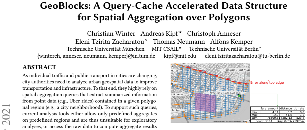
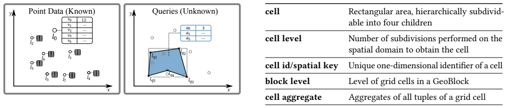
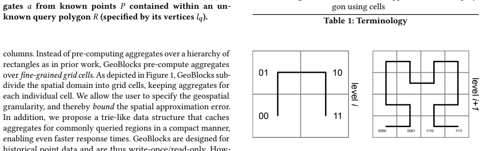
The load-bearing object is the cell covering of a query polygon in a hierarchical quadtree space decomposition, implemented with the S2 geometry library. A polygon is approximated by the set of grid cells it intersects; the maximum distance between any point on the covering and the polygon outline is bounded by the cell diagonal, so shrinking the cell size gives a user-defined spatial error bound. Around that covering sit the GeoBlock's sorted per-cell aggregates (count, min, max, sum per column), a global header for fast containment tests, and the AggregateTrie, a compact in-place trie whose nodes are two 32-bit offsets pointing to child nodes and cached aggregates. The covering is what lets GeoBlocks answer arbitrary-polygon queries, whereas prior pre-aggregation over rectangles could not offer a controllable error.
What would settle it
Take a polygon whose boundary passes through a very dense point cluster and compare GeoBlocks' count at several block levels against the exact count from the raw data; if the relative count error stays large and does not shrink as the cell size decreases, the bounded-error guarantee for aggregates fails.
Extended reading notes
Core claim
GeoBlocks replaces an arbitrary query polygon, on the fly, by a cell covering in a hierarchical quadtree decomposition, and answers the aggregation by combining pre-computed aggregates of the covering cells. The paper's central claim is that this makes polygonal aggregation practical for exploratory analysis: the user picks a cell level, the cell diagonal bounds the spatial distance between the covering and the true polygon, and because point data are sorted by spatial key with cell aggregates stored contiguously in that order, a SELECT query touches only the covering cells while a COUNT query uses offset/count arithmetic on the first and last contained cell. A trie-like AggregateTrie caches aggregates of frequently queried cells, so workloads with spatial skew speed up further. The experimental claim is that GeoBlocks outperforms on-the-fly aggregation by up to three orders of magnitude and reaches sub-second latencies on datasets with hundreds of millions of points.
Load-bearing premise
The argument assumes that a small cell size, which bounds how far the cell covering can stray from the polygon outline, also keeps the aggregate result close to the exact answer; but the number of extra points caught in the boundary strip depends on where the data are concentrated, not just on cell size.
Editorial extensions
If this is right
- Analysts can set a geometric precision dial and get aggregate results in sub-second time on static point sets of hundreds of millions of points.
- Repeated queries over the same or overlapping regions get faster over time as the AggregateTrie fills, adapting to workload skew without prior assumptions about which regions will be queried.
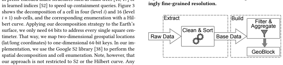
- Building many GeoBlocks for different filter predicates from one pass over sorted base data amortizes the sorting cost within a small number of filter changes.
- Query latency stays nearly constant as the dataset grows for a fixed spatial distribution, because it depends on the number of maintained cell aggregates rather than the number of points.
- The structure provides the first pre-aggregating way to handle arbitrary polygons with a bounded, user-controllable spatial error, extending pre-aggregation beyond rectangle-only queries.
Reading between the lines
- For applications that need exact counts, the cell covering would need to be paired with a refinement pass over points in the boundary strip, since the spatial bound alone does not control how many points fall in the strip.
- The same cell-covering and sorted-aggregate layout could serve approximate point-in-polygon membership and spatial join workloads, not only aggregation queries.
- Cache scoring by hit counts plus parent hits is a simple heuristic; weighting by polygon area or supporting sibling-subtraction aggregates could extend its reach on skewed workloads.
- For insert workloads, updates to existing cells are cheap, but inserts into previously empty regions require rebuilding the sorted aggregate layout; batching such inserts would keep the rebuild cost tolerable.
Signed reviews
Editorial analysis
A structured set of objections, weighed in public.
Referee Report
Summary. GeoBlocks proposes a pre-aggregated, grid-cell-based data structure for spatial aggregation over arbitrary polygons. Point data is mapped to an S2-style hierarchical cell decomposition, and each grid cell stores precomputed aggregates (count, sum, min, max). A query polygon is approximated by an S2 cell covering, and the user chooses the block level, which controls the spatial distance between the covering and the polygon outline. A second contribution is a trie-like query cache, the AggregateTrie, that stores aggregates for frequently queried cells. The paper evaluates GeoBlocks against binary-search, B-tree, PH-tree, and aR-tree baselines on NYC taxi, Twitter, and OSM data, reporting speedups of up to three orders of magnitude over on-the-fly aggregation and competitive performance with the aR-tree.
Significance. If the central claims hold after revision, the paper describes a practically attractive accelerator for interactive exploratory spatial analytics: a small, fast pre-aggregated index that supports arbitrary polygonal queries, admits a user-set geometric precision dial, and adapts to query skew through a cache. The experimental evaluation is broad and internally consistent, covering build time, space overhead, selectivity, dataset scale, and workloads with different skew. The authors clearly describe the storage layout, the query algorithms, and the caching heuristic, and they explicitly acknowledge some limitations of the cache-scoring rule. The main weakness is that the advertised 'bounded error' guarantee is not actually a bound on the error of the reported aggregate; this gap affects the paper's central novelty claim and must be addressed before the contribution can be assessed as stated.
major comments (3)
- [Abstract, Section 1, Section 3.2] The bounded-error guarantee is a geometric statement, not an aggregate-error statement. Section 3.2 proves that every point on a covering cell lies within sqrt(eps1^2+eps2^2) of the polygon outline, where eps1 and eps2 are the cell side lengths. This does not bound the error in the reported aggregate: for a COUNT query, the error is the number of data points that lie in the covering cells but outside the true polygon, and that number is controlled by the point distribution, not by the cell size. For any fixed block level, one can place arbitrarily many points in the boundary strip just outside a polygon edge, making the reported count arbitrarily larger than the true count; the same construction affects SUM, AVG, MIN, and MAX when the false-positive points carry extreme values. The paper's own Figure 16 observes a 'gap between the relative error and the configurable spatial error' caused by non-uniform point distribution, which is exactly this phenomenon. The abstract's claim that GeoBlocks 'allow to bound the approximation error by adjusting the cell size' and Section 1's claim of 'guarantees error-bounded results' therefore overstate what follows. Please either restate the guarantee as a spatial approximation bound (and add an explicit discussion of the distribution-dependent aggregate error), or supply a real bound on aggregate error, e.g., in terms of the number of points in boundary cells or a density-based estimate.
- [Section 4.2, Figures 14 and 15] The precision comparison is not controlled across approaches. The text states that Block, BinarySearch, and BTree 'use the same covering' and therefore have identical error, while PHTree and aRTree use a different rectangular representation. Consequently, the relative-error differences in Figures 14 and 15 mainly reflect the choice of query-region approximation (S2 covering vs. interior rectangle), not the effect of the pre-aggregation data structure itself. This does not support the claim in Section 4.2 that GeoBlocks deliver 'far more precise results' than the aR-tree. To make the precision claim meaningful, the experiments should compare all approaches against the same reference, for example by using the same covering for all methods or by reporting error with respect to the exact polygon result for every method.
- [Section 1 and Section 6 (related work)] The novelty claim that GeoBlocks are 'the first ... data structure that supports spatial aggregation over arbitrary polygons, while guaranteeing a bounded error' should be qualified. The cell-covering machinery, including the distance bound, comes from S2 and from prior approximate join work by the same group [16, 17, 52]; the genuinely new elements appear to be the block-level aggregate layout and the query-cache. Please position the 'first' claim with respect to this prior work, or restrict the novelty statement to the specific combination of pre-aggregation, arbitrary polygons, and the cache.
minor comments (5)
- [Section 3.2] The statement that 'the diagonal reduces by a factor of 2' per level assumes cells are squares; S2 cells are not exactly square, so the relationship between level and diagonal should be stated as approximate or taken from the S2 cell statistics table.
- [Section 3.5, Listing 1] The pseudocode uses s2.childrenAtLvl(qcell, BLOCK_LVL) and a later textual check 'until we reach a grid cell not contained in the query cell' that does not appear explicitly in the listing. Please make the termination condition and the handling of the AggregateTrie probe explicit, and define the notation consistently.
- [Section 3.5] The text says the cell covering 'cannot contain any cells smaller than the cells of the GeoBlock.' This is an invariant that must be enforced during cover generation; please state how it is guaranteed, since S2's default covering may return cells finer than the block level.
- [Section 4.2, Figure 14] The relative-error metric divides by the number of tuples in the polygon, which is undefined when a query polygon contains zero points. Please specify the handling of this degenerate case.
- [General] The notation 'aRTree' and 'aR-tree' is used inconsistently; please choose one form and use it throughout. Also, the phrase 'aRtree and PHTree use an identical rectangular representation' is imprecise, since the aR-tree uses a hierarchy of node MBRs rather than a single rectangle.
Circularity Check
No circular derivation: the geometric error bound and query-cache scoring are not fitted inputs or self-citation reductions.
full rationale
GeoBlocks' derivation chain is self-contained against external benchmarks. The cell-covering error bound in Section 3.2 is a geometric property of the S2 decomposition: any point on the covering lies within sqrt(eps1^2+eps2^2) of the polygon outline, and the user controls this spatial error by choosing the cell level. This is not a fitted parameter and is not defined in terms of the reported aggregate; it is computed directly from the covering geometry. The query-cache scoring rule in Section 3.6 is explicitly a stated heuristic ('We chose the above metric as it is sufficient to properly and repeatably represent the skew in the experiments') and is evaluated experimentally, not tuned against the reported results as a prediction. The self-citations [16,17,52] are used for optional encoding/indexing mechanisms and for the observation that an MBR cannot give a distance bound; none of these citations entails the new block layout, the COUNT range-sum trick, or the AggregateTrie cache. The MBR claim is independently derivable and is not load-bearing via self-citation. One genuine weakness exists, but it is a correctness issue rather than circularity: Section 3.2 proves a spatial error bound, while the abstract and Section 1 phrase it as a bound on the approximation error of the aggregation, and false-positive points in boundary cells can make count error data-dependent, as the paper itself acknowledges in Figure 16 ('a gap between the relative error and the configurable spatial error'). That mismatch does not reduce the derivation to its inputs; it is an overstatement of what the geometric guarantee implies. Overall, no step in the paper's claimed derivation is equivalent to its inputs by construction.
Assumptions & free parameters
free parameters (2)
- Block level (grid cell size) =
Default 17 in most experiments (~100 m diagonal); range 13-21 explored
- AggregateTrie size threshold =
5% of cell aggregate storage in default experiments; 1-100% explored
assumptions (5)
- domain assumption S2 library correctly computes cell coverings and order-preserving cell ids for arbitrary query polygons.
- standard math Aggregates are decomposable (count, sum, min, max; average as sum/count) so partial cell aggregates can be combined into polygon results.
- domain assumption The dataset is static or write-once/read-only, so the sorted cell-aggregate layout does not need online updates.
- domain assumption Point data is not pathologically concentrated near polygon boundaries, so the spatial distance bound implies practically bounded aggregate error.
- standard math Hilbert/space-filling enumeration maps each cell's descendants to a contiguous key interval, making the COUNT range formula correct.
Cite this review
Pith. "Pith review of GeoBlocks: A Query-Cache Accelerated Data Structure for Spatial Aggregation over Polygons." pith.science (2026). https://pith.science/paper/CBG3YYGB
@misc{pith2026190807753,
  author       = {Pith},
  title        = {Pith review of: GeoBlocks: A Query-Cache Accelerated Data Structure for Spatial Aggregation over Polygons},
  year         = {2026},
  howpublished = {\url{https://pith.science/paper/CBG3YYGB}},
  note         = {Machine review of arXiv:1908.07753}
}
read the original abstract
As individual traffic and public transport in cities are changing, city authorities need to analyze urban geospatial data to improve transportation and infrastructure. To that end, they highly rely on spatial aggregation queries that extract summarized information from point data (e.g., Uber rides) contained in a given polygonal region (e.g., a city neighborhood). To support such queries, current analysis tools either allow only predefined aggregates on predefined regions and are thus unsuitable for exploratory analyses, or access the raw data to compute aggregate results on-the-fly, which severely limits the interactivity. At the same time, existing pre-aggregation techniques are inadequate since they maintain aggregates over rectangular regions. As a result, when applied over arbitrary polygonal regions, they induce an approximation error that cannot be bounded. In this paper, we introduce GeoBlocks, a novel pre-aggregating data structure that supports spatial aggregation over arbitrary polygons. GeoBlocks closely approximate polygons using a set of fine-grained grid cells and, in contrast to prior work, allow to bound the approximation error by adjusting the cell size. Furthermore, GeoBlocks employ a trie-like cache that caches aggregate results of frequently queried regions, thereby dynamically adapting to the skew inherently present in query workloads and improving performance over time. In summary, GeoBlocks outperform on-the-fly aggregation by up to three orders of magnitude, achieving the sub-second query latencies required for interactive exploratory analytics.
Figures
Figures from the paper (13 more)




Reference graph
Works this paper leans on
-
[1]
W. G. Aref and H. Samet. Efficient processing of window queries in the pyramid data structure. In PODS, pages 265–272. ACM Press, 1990
work page 1990
-
[2]
E. Baralis, S. Paraboschi, and E. Teniente. Materialized views selection in a multidimensional database. In VLDB, pages 156–165, 1997
work page 1997
-
[3]
R. Bayer. The universal b-tree for multidimensional indexing: general concepts. In WWCA, pages 198–209. Springer, 1997
work page 1997
-
[4]
How to analyse bike data for urban planning? https://www.bikecitizens.net/ analyse-bike-data-urban-planning/
-
[5]
Boost R-tree. https://www.boost.org/doc/libs/1_69_0/libs/geometry/doc/html/ geometry/reference/spatial_indexes/boost__geometry__index__rtree.html
-
[6]
F. Braz, S. Orlando, R. Orsini, A. Raffaetà, A. Roncato, and C. Silvestri. Ap- proximate aggregations in trajectory data warehouses. In ICDE Workshops, pages 536–545, 2007
work page 2007
-
[7]
https://code.google.com/archive/p/cpp-btree/
Google code archive. https://code.google.com/archive/p/cpp-btree/
-
[8]
N. Ferreira, M. Lage, H. Doraiswamy, H. Vo, L. Wilson, H. Werner, M. Park, and C. Silva. Urbane: A 3d framework to support data driven decision making in urban development. In Proc. IEEE V AST, pages 97–104, 2015
work page 2015
Show all 56 references
-
[9]
R. A. Finkel and J. L. Bentley. Quad trees: A data structure for retrieval on composite keys. Acta Informatica, 4:1–9, 1974
1974
-
[10]
Geffner, D
S. Geffner, D. Agrawal, A. E. Abbadi, and T. R. Smith. Relative prefix sums: An efficient approach for querying dynamic OLAP data cubes. In ICDE, pages 328–335, 1999
1999
-
[11]
J. Gray, S. Chaudhuri, A. Bosworth, A. Layman, D. Reichart, M. Venkatrao, F. Pellow, and H. Pirahesh. Data cube: A relational aggregation operator generalizing group-by, cross-tab, and sub totals. Data Min. Knowl. Discov. , 1(1):29–53, 1997
1997
-
[12]
H. Gupta. Selection of views to materialize in a data warehouse. In ICDT, pages 98–112. Springer, 1997
1997
-
[13]
A. Guttman. R-trees: A dynamic index structure for spatial searching. In SIGMOD, pages 47–57. ACM Press, 1984
1984
-
[14]
J. Han, N. Stefanovic, and K. Koperski. Selective materialization: An efficient method for spatial data cube construction. InPAKDD, pages 144–158. Springer, 1998
1998
-
[15]
Harinarayan, A
V. Harinarayan, A. Rajaraman, and J. D. Ullman. Implementing data cubes efficiently. In SIGMOD, pages 205–216. ACM Press, 1996
1996
-
[16]
A. Kipf, H. Lang, V. Pandey, R. A. Persa, C. Anneser, E. Tzirita Zacharatou, H. Doraiswamy, P. A. Boncz, T. Neumann, and A. Kemper. Adaptive main- memory indexing for high-performance point-polygon joins. In EDBT, pages 347–358, 2020
2020
-
[17]
A. Kipf, H. Lang, V. Pandey, R. A. Persa, P. A. Boncz, T. Neumann, and A. Kem- per. Approximate geospatial joins with precision guarantees. In ICDE, pages 1360–1363. IEEE Computer Society, 2018
2018
-
[18]
Kriegel, H
H. Kriegel, H. Horn, and M. Schiwietz. The performance of object decom- position techniques for spatial query processing. In SSD, volume 525, pages 257–276. Springer, 1991
1991
-
[19]
Lazaridis and S
I. Lazaridis and S. Mehrotra. Progressive approximate aggregate queries with a multi-resolution tree structure. In SIGMOD, pages 401–412. ACM, 2001
2001
-
[20]
Lazaridis and S
I. Lazaridis and S. Mehrotra. Multi-resolution aggregate tree. In Encyclopedia of GIS, pages 764–765. Springer, 2008
2008
-
[21]
L. D. Lins, J. T. Klosowski, and C. E. Scheidegger. Nanocubes for real-time exploration of spatiotemporal datasets. IEEE Trans. Vis. Comput. Graph. , 19(12):2456–2465, 2013
2013
-
[22]
Liu and J
Z. Liu and J. Heer. The Effects of Interactive Latency on Exploratory Visual Analysis. Proc. TVCG, 20(12):2122–2131, 2014
2014
-
[23]
I. F. V. López, R. T. Snodgrass, and B. Moon. Spatiotemporal aggregate compu- tation: a survey. IEEE Trans. Knowl. Data Eng. , 17(2):271–286, 2005
2005
-
[24]
Nagel, P
F. Nagel, P. A. Boncz, and S. Viglas. Recycling in pipelined query evaluation. In ICDE, pages 338–349, 2013
2013
-
[25]
https://data.cityofnewyork.us/City-Government/ Neighborhood-Tabulation-Areas/cpf4-rkhq
NYC neighborhoods. https://data.cityofnewyork.us/City-Government/ Neighborhood-Tabulation-Areas/cpf4-rkhq
-
[26]
J. A. Orenstein. Spatial query processing in an object-oriented database system. In SIGMOD Conference, pages 326–336. ACM Press, 1986
1986
-
[27]
J. A. Orenstein and T. H. Merrett. A class of data structures for associative searching. In PODS, pages 181–190. ACM, 1984
1984
-
[28]
Pandey, A
V. Pandey, A. Kipf, T. Neumann, and A. Kemper. How good are modern spatial analytics systems? PVLDB, 11(11):1661–1673, 2018
2018
-
[29]
Pandey, A
V. Pandey, A. van Renen, A. Kipf, J. Ding, I. Sabek, and A. Kemper. The case for learned spatial indexes. In AIDB@VLDB, 2020
2020
-
[30]
Papadias, P
D. Papadias, P. Kalnis, J. Zhang, and Y. Tao. Efficient OLAP operations in spatial data warehouses. In SSTD, pages 443–459. Springer, 2001
2001
-
[31]
Papadias, Y
D. Papadias, Y. Tao, P. Kalnis, and J. Zhang. Indexing spatio-temporal data warehouses. In ICDE, pages 166–175, 2002
2002
-
[32]
Papadias, Y
D. Papadias, Y. Tao, J. Zhang, N. Mamoulis, Q. Shen, and J. Sun. Indexing and retrieval of historical aggregate information about moving objects. IEEE Data Eng. Bull., 25(2):10–17, 2002
2002
-
[33]
Pavlovic, D
M. Pavlovic, D. Sidlauskas, T. Heinis, and A. Ailamaki. QUASII: query-aware spatial incremental index. In EDBT, pages 325–336, 2018
2018
-
[34]
T. B. Pedersen and N. Tryfona. Pre-aggregation in spatial data warehouses. In SSTD, pages 460–480. Springer, 2001
2001
-
[35]
Phan and W
T. Phan and W. Li. Dynamic materialization of query views for data warehouse workloads. In ICDE, pages 436–445, 2008
2008
-
[36]
https://github.com/mcxme/phtree
mcxme/phtree. https://github.com/mcxme/phtree
-
[37]
F. Rao, L. Zhang, X. Yu, Y. Li, and Y. Chen. Spatial hierarchy and olap-favored search in spatial data warehouse. In DOLAP, pages 48–55. ACM, 2003
2003
-
[38]
https://s2geometry.io/
S2 geometry. https://s2geometry.io/
-
[39]
H. Samet. The quadtree and related hierarchical data structures.ACM Comput. Surv., 16(2):187–260, 1984
1984
-
[40]
Schneider
T. Schneider. Analyzing 1.1 Billion NYC Taxi and Uber Trips, with a Vengeance. https://toddwschneider.com/posts/analyzing-1-1-billion-nyc-taxi- and-uber-trips-with-a-vengeance/
-
[41]
V. Shah. Citi Bike 2017 Analysis - Towards Data Science . https:// towardsdatascience.com/citi-bike-2017-analysis-efd298e6c22c
2017
-
[42]
J. Shim, P. Scheuermann, and R. Vingralek. Dynamic caching of query results for decision support systems. In SSDBM, pages 254–263, 1999
1999
-
[43]
J. Shin, A. R. Mahmood, and W. G. Aref. An investigation of grid-enabled tree indexes for spatial query processing. In SIGSPATIAL, pages 169–178, 2019
2019
-
[44]
Shmueli and A
O. Shmueli and A. Itai. Maintenance of views. In SIGMOD, pages 240–255. ACM Press, 1984
1984
-
[45]
Shukla, P
A. Shukla, P. Deshpande, and J. F. Naughton. Materialized view selection for multidimensional datasets. In VLDB, pages 488–499, 1998
1998
-
[46]
Singla, A
S. Singla, A. Eldawy, R. Alghamdi, and M. F. Mokbel. Raptor: Large scale analysis of big raster and vector data. PVLDB, 12(12):1950–1953, 2019
1950
-
[47]
Sprenger, P
S. Sprenger, P. Schäfer, and U. Leser. Bb-tree: A main-memory index structure for multidimensional range queries. In ICDE, pages 1566–1569, 2019
2019
-
[48]
Y. Tao, G. Kollios, J. Considine, F. Li, and D. Papadias. Spatio-temporal aggre- gation using sketches. In ICDE, pages 214–225, 2004
2004
-
[49]
https://www1.nyc.gov/site/tlc/about/tlc-trip-record-data.page
Nyc tlc data. https://www1.nyc.gov/site/tlc/about/tlc-trip-record-data.page
-
[50]
http://tncstoday.sfcta.org/
TNCs TODAY. http://tncstoday.sfcta.org/
-
[51]
Tzirita Zacharatou, H
E. Tzirita Zacharatou, H. Doraiswamy, A. Ailamaki, C. T. Silva, and J. Freire. GPU rasterization for real-time spatial aggregation over arbitrary polygons. PVLDB, 11(3):352–365, 2017
2017
-
[52]
Tzirita Zacharatou, A
E. Tzirita Zacharatou, A. Kipf, I. Sabek, V. Pandey, H. Doraiswamy, and V. Markl. The case for distance-bounded spatial approximations. In CIDR. http://cidrdb.org, 2021
2021
-
[53]
https://movement.uber.com/
Uber Movement. https://movement.uber.com/
-
[54]
van Diggelen and P
F. van Diggelen and P. Enge. The world’s first GPS MOOC and worldwide laboratory using smartphones. In Proc. ION GNSS+, pages 361–369, 2015
2015
-
[55]
Vorona, A
D. Vorona, A. Kipf, T. Neumann, and A. Kemper. DeepSPACE: Approximate geospatial query processing with deep learning. In SIGSPATIAL/GIS, pages 500–503. ACM, 2019
2019
-
[56]
Zäschke, C
T. Zäschke, C. Zimmerli, and M. C. Norrie. The ph-tree: a space-efficient storage structure and multi-dimensional index. In SIGMOD, pages 397–408. ACM, 2014
2014
Reviewed August 14, 2026 · model on record in the stance chip above.
Discussion (0). Continue with ORCID to comment.