The NEFOCAST System for Detection and Estimation of Rainfall Fields by the Opportunistic Use of Broadcast Satellite Signals
Pith reviewed 2026-05-24 16:50 UTC · model grok-4.3
The pith
Two Kalman filters separate slow orbital drifts from fast rain fades to estimate rainfall from ordinary satellite TV signals.
A machine-rendered reading of the paper's core claim, the machinery that carries it, and where it could break.
Core claim
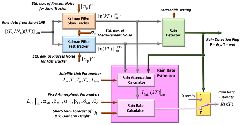
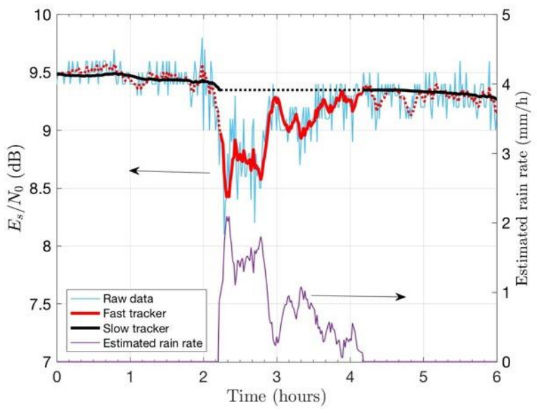
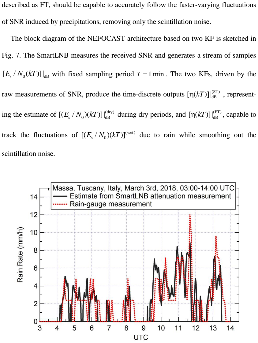
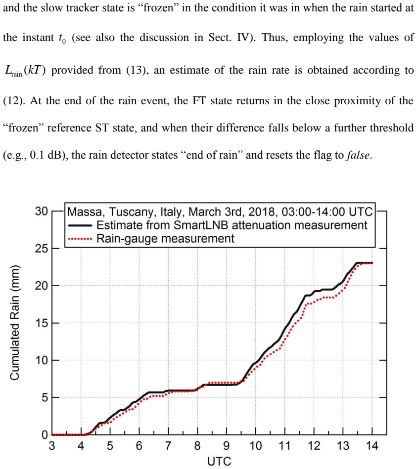
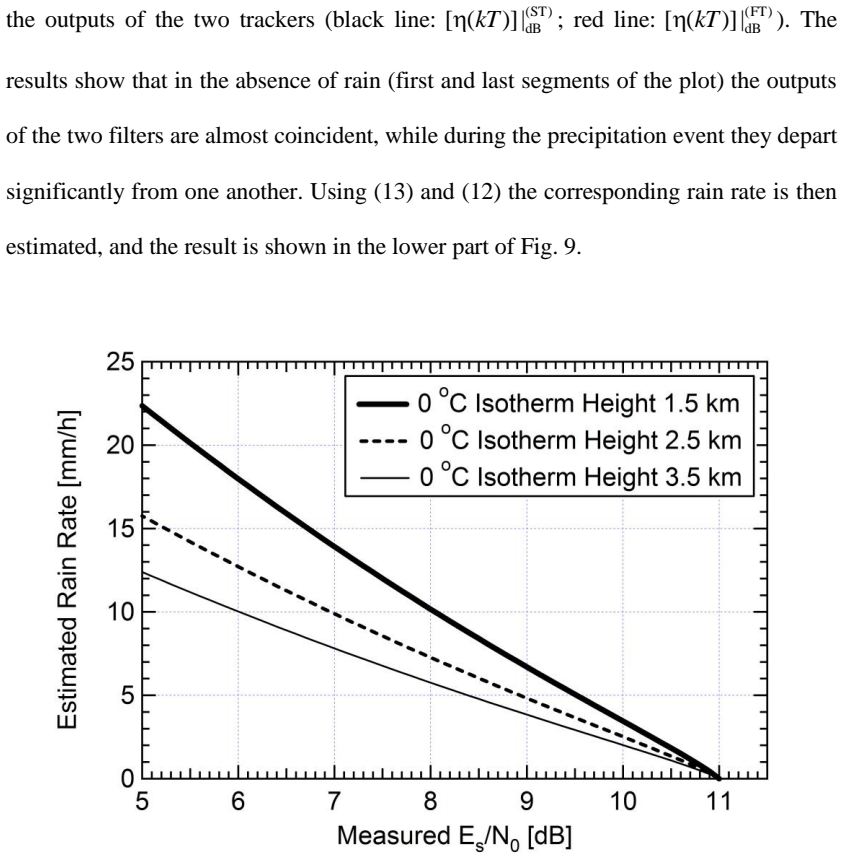
By employing two differentially-configured Kalman filters designed to track slow and fast changes of the received signal-to-noise ratio, rain events can be reliably detected and the relevant rainfall rate estimated from the rain-induced excess attenuation in DVB satellite signals, after counteracting orbital perturbations, refractive-index irregularities, and melting-layer fluctuations.
What carries the argument
two differentially-configured Kalman filters that track slow and fast changes in received signal-to-noise ratio
If this is right
- Rain events are distinguished from non-rain signal variations by time-scale separation.
- Rainfall rate is estimated directly from the excess attenuation once the filters isolate the rain component.
- Daily and seasonal random fluctuations in rain height are handled without dedicated sensors.
- Perturbations from lunar-solar gravity and Earth-mass inhomogeneity are removed before rain estimation.
Where Pith is reading between the lines
- A dense network of ordinary satellite receivers could produce rainfall maps at higher spatial resolution than sparse rain-gauge networks.
- The same time-scale approach might be tested on signals from other satellite constellations or frequency bands.
- Integration with existing weather models could supply real-time rain-field inputs in regions without radar coverage.
Load-bearing premise
Rain-induced excess attenuation can be separated from orbital perturbations, refractive-index fluctuations, and melting-layer variations solely by their different time scales using the two Kalman filters.
What would settle it
A recorded rain event whose attenuation time scale matches an orbital correction or melting-layer shift, so that the filters assign the change to the wrong category.
Figures
read the original abstract
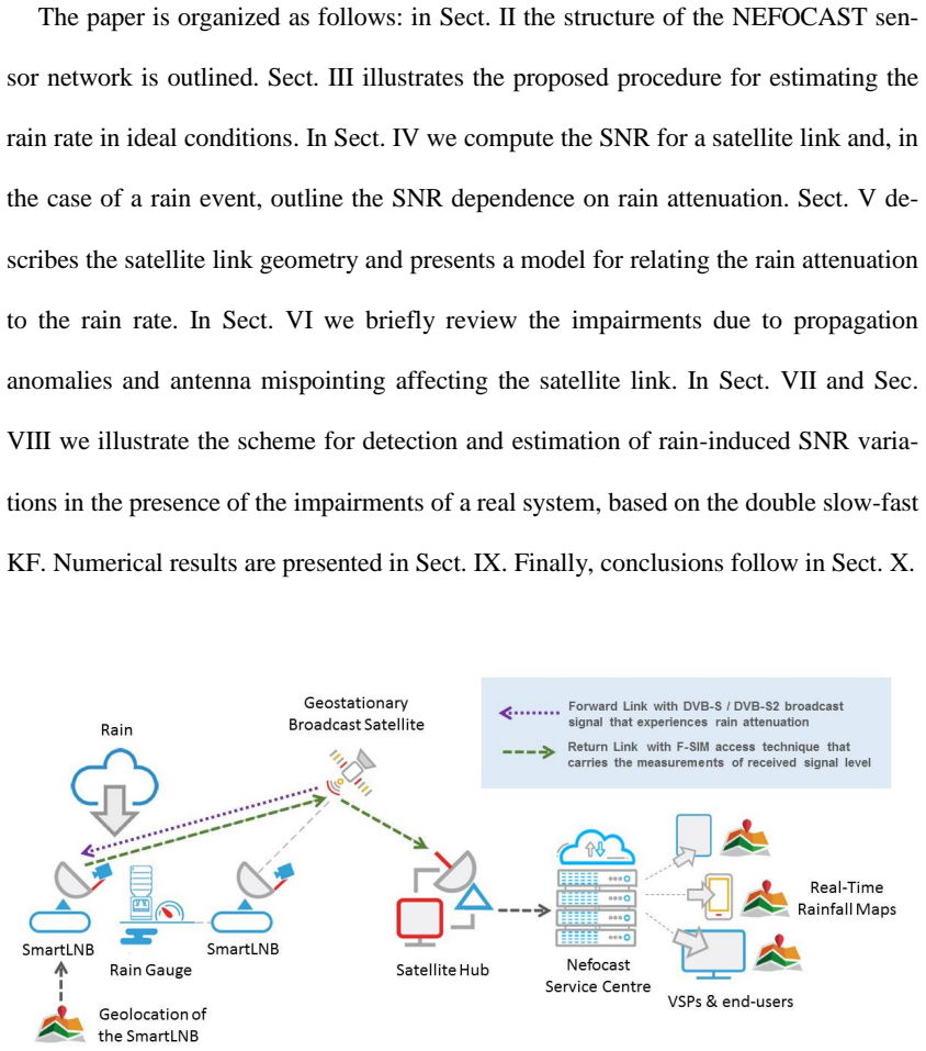
In this paper we present results from the NEFOCAST project, funded by the Tuscany Region, aiming at detecting and estimating rainfall fields from the opportunistic use of the rain-induced excess attenuation incurred in the downlink channel by a commercial DVB satellite signal. The attenuation is estimated by reverse-engineering the effects of the various propagation phenomena affecting the received signal, among which, in first place, the perturbations factors affecting geostationary orbits, such as the gravitational attraction from the moon and the sun and the inhomogeneity in Earth mass distribution and, secondly, the small-scale irregularities in the atmospheric refractive index, causing rapid fluctuations in signal amplitude. The latter impairments, in particular, even if periodically counteracted by correction maneuvers, may give rise to significant departures of the actual satellite position from the nominal orbit. A further problem to deal with is the daily and seasonal random fluctuation of the rain height and altitude/size of the associated melting layer. All of the above issues lead to non-negligible random deviations from the dry nominal downlink attenuation, that can be misinterpreted as rain events. In this paper we show how to counteract these issues by employing two differentially-configured Kalman filters designed to track slow and fast changes of the received signal-to-noise ratio, so that the rain events can be reliably detected and the relevant rainfall rate estimated.
Editorial analysis
A structured set of objections, weighed in public.
Referee Report
Summary. The manuscript presents the NEFOCAST system for detecting and estimating rainfall fields via opportunistic measurement of rain-induced excess attenuation on commercial DVB satellite downlink signals. It identifies confounders including orbital perturbations from lunar/solar gravity and Earth mass inhomogeneity, refractive-index fluctuations causing scintillation, and daily/seasonal variations in rain height and melting layer. The central approach uses two differentially-configured Kalman filters to track slow and fast changes in received SNR, thereby isolating rain events for reliable detection and rainfall-rate estimation.
Significance. If the time-scale separation and resulting estimates prove accurate, the work could enable low-cost, wide-area rainfall monitoring by repurposing existing satellite broadcast infrastructure without dedicated sensors. However, the abstract supplies no error statistics, detection probabilities, rate-estimation accuracy, or comparisons against rain gauges, so the practical significance cannot yet be evaluated. The method applies standard Kalman tracking to an external physical quantity rather than introducing new derivations or parameter-free results.
major comments (2)
- [Abstract] Abstract (final sentence): the claim that the two Kalman filters enable 'reliable' detection and rainfall-rate estimation is load-bearing for the entire contribution, yet the provided text contains no quantitative validation, no error metrics, no ground-truth comparisons, and no description of how the process/measurement noise covariances were selected or tuned.
- [Abstract] Abstract: the separation of rain-induced excess attenuation from orbital perturbations, refractive-index fluctuations, and melting-layer variations rests on the assumption that these effects occupy sufficiently disjoint time scales. No spectral analysis, transfer-function characterization of the filters, or quantitative bounds on the frequency content of each confounder are supplied to demonstrate that the slow/fast split avoids misattribution.
Simulated Author's Rebuttal
We thank the referee for the detailed review and constructive comments on our manuscript. We address each major comment below.
read point-by-point responses
-
Referee: [Abstract] Abstract (final sentence): the claim that the two Kalman filters enable 'reliable' detection and rainfall-rate estimation is load-bearing for the entire contribution, yet the provided text contains no quantitative validation, no error metrics, no ground-truth comparisons, and no description of how the process/measurement noise covariances were selected or tuned.
Authors: The abstract is a concise summary; the full manuscript provides quantitative validation through ground-truth comparisons with rain gauges, detection probabilities, rate-estimation RMSE, and details on covariance tuning via empirical clear-sky and rain-event data in Sections III and IV. We will revise the abstract to incorporate key performance metrics for completeness. revision: yes
-
Referee: [Abstract] Abstract: the separation of rain-induced excess attenuation from orbital perturbations, refractive-index fluctuations, and melting-layer variations rests on the assumption that these effects occupy sufficiently disjoint time scales. No spectral analysis, transfer-function characterization of the filters, or quantitative bounds on the frequency content of each confounder are supplied to demonstrate that the slow/fast split avoids misattribution.
Authors: The separation relies on well-established physical time scales (orbital and rain-height effects over hours to days; scintillation over seconds to minutes). The differentially configured Kalman filters use distinct process-noise settings to track these regimes. While the manuscript does not include explicit spectral analysis, we can add a brief discussion or supplementary material with frequency-content bounds to further substantiate the approach. revision: partial
Circularity Check
No circularity: standard Kalman application to external SNR data with no self-referential reduction.
full rationale
The paper's central method applies two differentially-configured Kalman filters to track slow and fast SNR changes for rain detection and rate estimation. The provided abstract and description contain no equations, derivations, or self-citations that reduce the claimed rainfall estimate to a fitted parameter defined by the same data or to a self-citation chain. The time-scale separation is presented as an application of standard filtering to an external physical quantity (rain-induced attenuation), not as a quantity defined in terms of itself. No load-bearing step reduces by construction to the inputs.
Axiom & Free-Parameter Ledger
free parameters (1)
- Kalman filter process and measurement noise covariances
axioms (1)
- domain assumption Rain attenuation exhibits a distinct temporal signature separable from orbital and refractive perturbations by linear filtering
Reference graph
Works this paper leans on
-
[1]
Rainfall as a landslide triggering factor an overview of recent international research
M. Polemio, O. Petrucci , "Rainfall as a landslide triggering factor an overview of recent international research", 8th Int. Symp . on Landslides: Landslides in research, theory and practice, pp 1219-1226, 2000
work page 2000
-
[2]
Remote sensing of Clouds and Precipitation
C. Andronache (ed), "Remote sensing of Clouds and Precipitation”, Springer, pp XIV, 282, 2018
work page 2018
-
[3]
G. Villarini, P. V. Mandapaka, W. F. Krajewski, R. J. Moore, Rainfall and sampli ng uncertainties: A rain gauge perspective, J. Geophys. Res., 113, D11102, 2008
work page 2008
-
[4]
On precipitation measurements collected by a weather radar and a rain gauge network,
S. Sebastianelli et al., "On precipitation measurements collected by a weather radar and a rain gauge network," Nat. Hazards Earth Syst. Sci., 13, 605-623, 2013
work page 2013
-
[5]
G. Panegrossi et al., "Use of the GPM constellation for monitoring heavy precipitation events over the mediterranean region, " IEEE J. Sel. Topics Appl. Earth Observ. Rem. Sens. , vol. 9, no. 6, pp. 2733–2753, Jun. 2016
work page 2016
-
[6]
The potential of SmartL NB networks for rainfall estimation
F. Giannetti et al., “The potential of SmartL NB networks for rainfall estimation” , 2018 IEEE Workshop on Statistical Signal Processing (SSP), Freiburg, pp. 120-124, 2018
work page 2018
-
[7]
Chwala, C.; Gmeiner, A.; Qiu, W.; Hipp, S.; Nienaber, D.; Siart, U.; Eibert, T.; Pohl, M.; Seltmann, J.; Fritz, J. et al. Precipit ation observation using microwave backhaul links in the alpine and pre - alpine region of Southern Germany. Hydrol. Earth Syst. Sci. 2012, 16, 2647–2661
work page 2012
-
[8]
Wireless Communication Links as Opportunistic IoT for Near Ground Rain Monitoring
H. Messer, “ Wireless Communication Links as Opportunistic IoT for Near Ground Rain Monitoring”, 2018 IEEE Workshop on Statistical Signal Processing (SSP), Freiburg, pp. 115 - 119, 2018
work page 2018
-
[9]
Rainfall Measurements Using Satellite Downlink Attenuation
Arslan, C.H.; Aydin, K.; Urbina, J.; Dyrud, L.P. Rainfall Measurements Using Satellite Downlink Attenuation. In Proceedings of the IEEE International Geoscience and Remote Sensing Symposium (IGARSS), Quebec City, QC, Canada, 13–18 July 2014; pp. 4111–4114
work page 2014
-
[10]
Mugnai, C.; Sermi, F.; Cuccoli, F.; Facheris, L. Rainfall Estimation with a Commercial Tool for Satellite Internet in Ka Band: Model Evolution and Results. In Proceedings of the IEEE International Geoscience and Remote Sensing Symposium (IGARSS), Milan, Italy, 26 –31 July 2015; pp. 890–893
work page 2015
-
[11]
Rainfall measurement from the opportunistic use of earth -space link in the Ku band
Barthès, F.; Mallet, C. Rainfall measurement from the opportunistic use of earth -space link in the Ku band. Atmos. Meas. Tech. 2013, 6, 2181–2193
work page 2013
-
[12]
Mercier, F.; Barthes, F.; Mallet, C. Estimation of finescale rainfall fields using broadcast TV satellite links and a 4DVAR assimilation method. J. Atmos. Ocean. Technol. 2015, 32, 1709–1728
work page 2015
-
[13]
Real -Time Rain Rate Evaluation via Satellite Downlink Signal Attenuation Measurement,
F. Giannetti et al., "Real -Time Rain Rate Evaluation via Satellite Downlink Signal Attenuation Measurement," Sensors, 2017, 17(8). 31
work page 2017
-
[14]
G. Bacci, et al. "The NEFOCAST project: A nowcasting weather platform based on dual - frequency interactive satellite terminals." General Assembly and Scientific Symposium of the International Union of Radio Science (URSI GASS), 2017 XXXIInd. IEEE, 2017
work page 2017
-
[15]
E.Adirosi et al., "NEFOCAST project for real -time precipitation estimation from Ku satellite links: Preliminary results of the validation field campaign", 2nd URSI AT -RASC, pp. 1-4, Gran Canaria, 28 May – 1 June 2018
work page 2018
- [16]
-
[17]
A. Arcidiacono et al., "From S -band mobile interactive multimedia to fixed satellite interactive multimedia: making satellite interactivity affordable at Ku -band and Ka -band," Int. J. of Satellite Communications and Networking ,Vol. 34, Issue 4, July/August 2016, pp. 575 –601
work page 2016
-
[18]
Satellite Communication Systems
G. Maral, M. Bousquet, “Satellite Communication Systems”, 5th edition, John Wiley, UK 2002
work page 2002
-
[19]
Assessment of radar signal attenuation caused by the melting hydrometeor layer,
S.Y. Matrosov, "Assessment of radar signal attenuation caused by the melting hydrometeor layer," IEEE Trans. on Geoscience and Remote Sensing, 46(4), 1039-1047, 2008
work page 2008
-
[20]
L. Baldini E. Gorgucci "Iden tification of the Melting Layer through Dual -Polarization Radar Measurements at Vertical Incidence" Journal of Atmos. and Oceanic Technol. vol. 23 no. 6 pp. 829-839 2006
work page 2006
-
[21]
Radar and attenuation pro perties of rain and bright band,
A.W. Dissanayake, N. J. McEwan, "Radar and attenuation pro perties of rain and bright band," Antennas and Propagation, 1978
work page 1978
-
[22]
TRMM PR Standard Algorithm and its Performance on Bright Band Detection,
J. Awaka, T. Iguchi, K. Okamoto, "TRMM PR Standard Algorithm and its Performance on Bright Band Detection," Journal of the Meteorological Society of Japan, vol. 87A, pp. 31–52, 2009
work page 2009
-
[23]
Rain Heigh t Information from TRMM Precipitation Radar,
M. Thurai, T. Iguchi, "Rain Heigh t Information from TRMM Precipitation Radar," Electronics Letters 36(12), pp. 1059 – 1061, July 2000
work page 2000
-
[24]
Rain Height Information from TRMM Precipitation Radar for Satellite Communication in Malaysia,
M.A.N. Azlan, J. Din, H.Y. Lam, "Rain Height Information from TRMM Precipitation Radar for Satellite Communication in Malaysia," in Proceedings of the IEE E International Conference on Space Science and Communication (IconSpace), Penang, Malaysia, 1213 July 2011
work page 2011
-
[25]
Satellite communications at Ku, Ka, and V bands: Propagation impair ments and mitigation techniques,
A.D. Panagopoulos, P. -D. M. Arapoglou, and P. G. Cottis. "Satellite communications at Ku, Ka, and V bands: Propagation impair ments and mitigation techniques," IEEE Communications Surveys & Tutorials 6.3 (2004)
work page 2004
-
[26]
Analysis of Tropospheric Scintillation Intensity on Earth to Space in Malaysia,
M.S.J. Singh, S.I.S. Hassan, M.F. Ain, K. Igarashi, K. Tanaka, and M. Iida, "Analysis of Tropospheric Scintillation Intensity on Earth to Space in Malaysia," American J. of Appl. Sciences 3 (9), pp. 2029-2032, 2006
work page 2029
-
[27]
P. W. Fortescue and J. P. W. Stark, Spacecraft Systems Engineering. Chichester: Wiley, 2011
work page 2011
-
[28]
Propagation data required for the design of broadcasting -satellite systems,
"Propagation data required for the design of broadcasting -satellite systems," Recommendation ITU-R P.679-4, 2005
work page 2005
discussion (0)
Sign in with ORCID, Apple, or X to comment. Anyone can read and Pith papers without signing in.