REVIEW 3 major objections 5 minor 43 references
A Root-Zone Soil Salinity Observatory for Coastal Southwest Bangladesh
T0 review · 3 major / 5 minor · reviewed 2026-08-10 · deepseek-v4-flash
Pith's one-line read A 162-point topsoil survey of coastal southwest Bangladesh, collected in March 2024 and measured with the standard 1:5 soil-water electrical-conductivity protocol, finds salinity from 0.05 to 9.09 mS/cm, highest near Debhata and Koyra…
desk verdict A straightforward data paper whose new 162-point EC dataset is useful for a data-sparse region, but the absolute salinity values are not anchored by QA/QC details, so the gradient is the robust half. read the letter →
The pith
A machine-rendered reading of the paper's core claim, the machinery that carries it, and where it could break.
The reading
What carries the argument
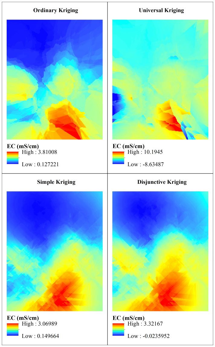
The load-bearing object is the 162-point geocoded topsoil EC dataset, each point a composite of 5 to 10 samples from the top 30 cm of dry, open, fallow fields, dried, sieved, and measured in a 1:5 soil-water suspension with a benchtop conductivity meter following a standard operating procedure. The interpolation machinery is Empirical Bayesian Kriging, a geostatistical estimator that weights nearby samples through a spatial covariance model and supplies uncertainty estimates; the paper selects it after comparing five kriging variants by leave-one-out RMSE.
What would settle it
Take the archived samples back to a second laboratory, measure each in triplicate against calibrated standards, and also revisit a north-south string of the original sites to collect new samples in the same season. If the high values near Debhata and Koyra do not reproduce, or if the re-sampled values do not increase from north to south, the paper's claimed range and gradient would not survive.
Extended reading notes
Core claim
The central claim is that a spatially dense, seasonally consistent field measurement campaign can characterize root-zone soil salinity across the southwest Bangladesh coast at a detail that remote-sensing maps alone cannot provide. The paper reports 162 geocoded topsoil EC values with a measured range of 0.05 to 9.09 mS/cm, a concentration of the highest values (5.83 to 9.09 mS/cm) around Debhata and Koyra, and a consistent north-to-south gradient visible in longitudinal cross-sections. It further claims that Empirical Bayesian Kriging is the best of five tested kriging approaches for turning these points into a regional surface, selected by leave-one-out cross-validation RMSE of 1.3 mS/cm, and that the resulting pattern agrees with earlier published salinity distributions in both magnitude and spatial trend.
Load-bearing premise
The load-bearing assumption is that each mixed soil sample's single lab measurement is trustworthy, so the reported salinity range and the north-south trend reflect the ground and not meter drift or handling mistakes.
Editorial extensions
If this is right
- The March 2024 dataset establishes a current, spatially dense reference point that can be compared directly with older regional salinity maps to estimate whether salt-affected land has expanded.
- The interpolated Empirical Bayesian Kriging surface, with its reported leave-one-out RMSE of 1.3 mS/cm, gives planners a sub-district view of where salinity is highest, specifically around Debhata and Koyra, and where adaptation measures should be prioritized first.
- The north-to-south salinity gradient provides a testable expectation: interventions suited to low-salinity conditions should work in the northern part of the study area, while the southern upazilas require salt-tolerant crops or water management.
- Because each site is geocoded and photo-documented, the same routes can be revisited in later seasons or years, making the dataset the baseline layer for the persistent soil-salinity observatory the authors describe.
- The dataset also gives remote-sensing salinity studies a local validation source: 162 ground-truth EC points in a region where previous ground data were sparse.
Reading between the lines
- Editorial inference: the single dry-season campaign window means the reported values are a low-storm, pre-monsoon snapshot; a monsoon or post-cyclone campaign could find a different range, and the north-south contrast might sharpen after saline inundation.
- Editorial inference: the 1:5 soil-water dilution yields lower EC readings than saturated-paste extracts, the agronomic standard; interpreting the 9.09 mS/cm maximum in saturated-paste terms would place the Koyra-Debhata soils in the strongly saline class for crop growth.
- Editorial inference: the paper's agreement with earlier studies is qualitative; a direct, spatially explicit comparison with the pre-2010 coastal maps would quantify how much of the observed gradient is long-standing and how much has shifted in the last decade.
- Editorial inference: the same sampling protocol could be extended to depth profiles and to wet-season timing to distinguish permanent saline conditions from seasonal salt flushing.
Signed reviews
Editorial analysis
A structured set of objections, weighed in public.
Referee Report
Summary. The paper presents a soil salinity dataset for coastal southwest Bangladesh, comprising 162 topsoil samples collected March 1–9, 2024, from three districts (Khulna, Satkhira, Jessore). Samples were processed with the FAO 1:5 soil-water SOP and EC was measured with a HI-6321 benchtop meter. The authors report a salinity range of 0.05–9.09 mS/cm, with highest values near Debhata and Koyra, and a north–south increasing gradient. The data are visualized with bubble maps and kriging interpolation, and the dataset is archived on Zenodo. The central claim is the new, spatially dense field dataset and its interpolated salinity distribution.
Significance. If the measurements are accurate, this dataset addresses a genuine gap: the most recent SRDI coastal soil salinity dataset is about 14 years old, and few studies provide dense spatial sampling of topsoil in this region. The 162-sample campaign, the explicit field protocol, and the public archive are concrete strengths. The north–south gradient is consistent with prior regional studies, giving qualitative credibility. However, the absolute salinity values—the claimed 0.05–9.09 mS/cm range—depend on unverified laboratory quality control. The paper's value as a reference dataset rests on demonstrating that the EC readings are traceable and reproducible, which the current manuscript does not establish.
major comments (3)
- [Data processing in laboratory; Data Records] The manuscript reports one HI-6321 reading per composite sample (Figure 4(j)) and asserts in Data Records that 'calibrating sensors' was part of the workflow, but it does not specify the calibration standard, its concentration, the calibration frequency, the meter's stated accuracy, temperature compensation, or any QC samples (blanks, duplicates, or certified reference materials). Because the absolute values and the 0.05–9.09 mS/cm range are the central claim, the absence of this information leaves the quantitative scale unverified. Please provide the calibration details and QC results, or clearly state their absence and discuss the resulting uncertainty.
- [Technical Validation, Table 1 and RMSE] The RMSE of the Empirical Bayesian Kriging is reported as '1.3' without units; since EC is in mS/cm, the RMSE must be reported as mS/cm with the appropriate significant figures. More importantly, the Technical Validation table compares the present results to literature values reported only as 'EC in dS/m or mS/cm' without disclosing whether those studies used 1:5 extracts or saturated-paste ECe. These protocols differ by factors of roughly 3–10, so the claimed 'correspondence' cannot validate the absolute values. Please clarify the protocols of the cited studies or restrict the comparison to spatial pattern.
- [Technical Validation, paragraph on interpolation] The manuscript states that geostatistical methods outperform deterministic methods and that Empirical Bayesian Kriging 'shows the most accurate result for this dataset among several types of Kriging,' but the only methods compared are kriging variants. No comparison with IDW, spline, natural neighbor, or other deterministic interpolators is reported for this dataset. Additionally, the leave-one-out cross-validation selects the model on the same dataset used to produce the final map; the claim that EBK is the most accurate is therefore limited to the kriging family. Please either report the broader comparison or temper the claim accordingly.
minor comments (5)
- [Abstract and Data Records] The term 'root-zone' is used in the title and abstract, but samples were collected from 0–30 cm depth, which is described as topsoil; please clarify whether this constitutes the root zone for the intended agricultural applications.
- [Figure 7 caption] The caption states EC levels range from 0.5 to 6.5 mS/cm, while the abstract and Figure 5 use a range of 0.05 to 9.09 mS/cm; please reconcile these values.
- [Introduction, Section 1.4] There is a typo in 'W ARPO' in the list of organizations; it should read 'WARPO'.
- [Figure 6 and Section 3] The cross-section C-C' is described as showing an increase 'from west to east' while the longitudinal sections A-A' and B-B' show an increase 'from north to south'; this is fine, but the figure labels and the text should be checked for consistency because the same notation C-C' appears twice.
- [Data Records] The sentence 'The geographical location of sample sites, data collection, and soil salinity values (EC in mS/cm, constitute the metadata' has a grammatical error and an unmatched parenthesis; please revise.
Circularity Check
No circular derivation: the paper reports a field-measured EC dataset with internal cross-validation; self-citations provide context, not load-bearing input.
full rationale
This is a data-descriptor paper whose central deliverable is 162 field-collected topsoil EC measurements processed with the FAO 1:5 soil-water protocol. There is no equation-level derivation chain, no fitted parameter renamed as a prediction, and no imported uniqueness theorem. The interpolation step uses Empirical Bayesian Kriging selected by leave-one-out cross-validation on the same dataset; this is an internal model-selection procedure, not a claim that the dataset itself is predicted from an assumed model. The Technical Validation section compares the observed spatial pattern with prior literature, including two Sarkar et al. 2023 studies with overlapping authorship. Those citations are used as external context for the north-south gradient and are not the source of the measured EC values, so they are not load-bearing circularity. Concerns such as the single HI-6321 reading per composite sample and the unsupported assertion that sensors were calibrated are measurement-quality and reproducibility issues, not circular-reasoning issues. No circular step can be exhibited by quoting an equation or by showing that an output is definitionally equal to an input; the appropriate finding is no significant circularity.
Assumptions & free parameters
free parameters (1)
- Empirical Bayesian Kriging hyperparameters (variogram and subset settings) =
not reported
assumptions (3)
- domain assumption The FAO 1:5 soil-water EC protocol is a valid measure of soil salinity.
- domain assumption Kriging interpolation is appropriate for these 162 points; spatial autocorrelation is assumed.
- domain assumption The March 2024 dry-season snapshot is representative of regional soil salinity distribution.
Cite this review
Pith. "Pith review of A Root-Zone Soil Salinity Observatory for Coastal Southwest Bangladesh." pith.science (2026). https://pith.science/paper/EKJWS2VO
@misc{pith2026241219740,
  author       = {Pith},
  title        = {Pith review of: A Root-Zone Soil Salinity Observatory for Coastal Southwest Bangladesh},
  year         = {2026},
  howpublished = {\url{https://pith.science/paper/EKJWS2VO}},
  note         = {Machine review of arXiv:2412.19740}
}
read the original abstract
The research assesses soil salinity in the southwest coastal region of Bangladesh, collecting a total of 162 topsoil samples between March 1 and March 9, 2024, and processing them following the standard operating procedure for soil electrical conductivity (soil/water, 1:5). Electrical conductivity (EC) measurements obtained using a HI-6321 advanced conductivity benchtop meter were analyzed and visualized using bubble density mapping and the Empirical Bayesian Kriging interpolation method. The findings indicate that soil salinity in the study area ranges from 0.05 to 9.09 mS/cm, with the highest levels observed near Debhata and Koyra. A gradient of increasing soil salinity is clearly evident from the northern to southern regions. This dataset provides a critical resource for soil salinity-related research in the region, offering valuable insights to support decision-makers in understanding and mitigating the impacts of soil salinity in Bangladesh's coastal areas.
Figures


Figures from the paper (6 more)



Reference graph
Works this paper leans on
-
[1]
Morshed, M. M., Islam, M. T. & Jamil, R. Soil salinity detection from satellite image analysis: an integrated approach of salinity indices and field data. Environ. monitoring assessment 188, 1–10, https://doi.org/10.1007/s10661-015-5045-x (2016)
-
[2]
Wu, J., Vincent, B., Yang, J., Bouarfa, S. & Vidal, A. Remote sensing monitoring of changes in soil salinity: a case study in inner mongolia, china. Sensors 8, 7035–7049, https://doi.org/10.3390/s8117035 (2008)
doi:10.3390/s8117035 2008
-
[3]
Negacz, K., Malek, Ž., de V os, A. & Vellinga, P. Saline soils worldwide: Identifying the most promising areas for saline agriculture. J. arid environments 203, 104775, https://doi.org/10.1016/j.jaridenv.2022.104775 (2022)
arXiv 2022
-
[4]
Global map of salt-affected soils (2024)
Food and Agriculture Organization of the United Nations. Global map of salt-affected soils (2024). Accessed: 20-10-2024
work page 2024
-
[5]
Morshed, M. M., Sarkar, S. K., Zzaman, M. R. U. & Islam, M. M. Application of remote sensing for salinity based coastal land use zoning in bangladesh. Spatial Inf. Res. 29, 353–364, https://doi.org/10.1007/s41324-020-00357-3 (2021)
-
[6]
Cropland soil salinization and associated hydrology: Trends, processes and examples
Nachshon, U. Cropland soil salinization and associated hydrology: Trends, processes and examples. Water 10, 1030, https://doi.org/10.3390/w10081030 (2018)
-
[7]
F., DeSutter, T., Chatterjee, A
Butcher, K., Wick, A. F., DeSutter, T., Chatterjee, A. & Harmon, J. Soil salinity: A threat to global food security. Agron. J. 108, 2189–2200, https://doi.org/10.2134/agronj2016.06.0368 (2016)
-
[8]
Sarkar, S. K., Rahman, M. A., Esraz-Ul-Zannat, M. & Islam, M. F. Simulation-based modeling of urban waterlogging in khulna city. J. Water Clim. Chang. 12, 566–579, https://doi.org/10.2166/wcc.2020.256 (2021)
Show all 43 references
-
[9]
& Shang, S
Wan, H., Qi, H. & Shang, S. Estimating soil water and salt contents from field measurements with time domain reflectometry using machine learning algorithms. Agric. Water Manag. 285, 108364, https://doi.org/10.1016/j.agwat.2023.108364 (2023)
2023
-
[10]
& Ravela, S
Saha, A. & Ravela, S. Rapid statistical-physical adversarial downscaling reveals bangladesh’s rising rainfall risk in a warming climate. arXiv 2408.11790 (2024)
2024 arXiv
-
[11]
& Ravela, S
Saha, A. & Ravela, S. Rapid climate model downscaling to assess risk of extreme rainfall in bangladesh in a warming climate. arXiv 2412.16407 (2024)
2024 arXiv
-
[12]
& Emanuel, K
Qiu, J., Ravela, S. & Emanuel, K. Bangladesh’s accelerating coastal flood hazard. arXiv 2312.06051 (2023)
2023 arXiv
-
[13]
Rudra, R. R. & Sarkar, S. K. Artificial neural network for flood susceptibility mapping in bangladesh. Heliyon 9, https://doi.org/10.1016/j.heliyon.2023.e16459 (2023)
2023 doi
-
[14]
& Hossain, T
Hasan, M., Rahman, M., Haque, A. & Hossain, T. Soil salinity hazard assessment in bangladesh coastal zone. In Proceedings of the International Conference on Disaster Risk Management, Dhaka, Bangladesh , 12–14 (2019)
2019
-
[15]
K., Rudra, R
Sarkar, S. K., Rudra, R. R., Nur, M. S. & Das, P. C. Partial least-squares regression for soil salinity mapping in bangladesh. Ecol. Indic. 154, 110825, https://doi.org/10.1016/j.ecolind.2023.110825 (2023)
2023
-
[16]
Akash, S. H. et al. Assessment of coastal vulnerability using integrated fuzzy analytical hierarchy process and geospatial technology for effective coastal management. Environ. Sci. Pollut. Res. 31, 53749–53766, https://doi.org/10.1007/ s11356-023-28317-y (2024)
2024
-
[17]
Sarkar, S. K. et al. Coupling of machine learning and remote sensing for soil salinity mapping in coastal area of bangladesh. Sci. Reports 13, 17056, https://doi.org/10.1038/s41598-023-44132-4 (2023)
2023 doi
-
[18]
& Chelleri, L
Fatori´c, S. & Chelleri, L. Vulnerability to the effects of climate change and adaptation: The case of the spanish ebro delta. Ocean. & Coast. Manag. 60, 1–10, https://doi.org/10.1016/j.ocecoaman.2011.12.015 (2012)
2012 doi
-
[19]
Uzzaman, M. A. Impact of sea level rise in the coastal areas of bangladesh: A macroeconomic analysis. J. Econ. Sustain. Dev. 5, 105–109 (2014)
2014
-
[20]
& Dietz, K.-J
Zörb, C., Geilfus, C.-M. & Dietz, K.-J. Salinity and crop yield. Plant biology 21, 31–38, https://doi.org/10.1111/plb.12884 (2019)
2019 doi
-
[21]
O., Nasurudeen, P
Umamaheswari, L., Hattab, K. O., Nasurudeen, P. & Selvaraj, P. Should shrimp farmers pay paddy farmers?: the challenges of examining salinisation externalities in south india. SANDEE working paper/South Asian Netw. for Dev. Environ. Econ. no. 41-09 (2009)
2009
-
[22]
G., Gold, A
Wongsirikajorn, M., McNally, C. G., Gold, A. J. & Uchida, E. High salinity in drinking water creating pathways towards chronic poverty: A case study of coastal communities in tanzania. Ambio 52, 1661–1675, https://doi.org/10.1007/ s13280-023-01879-4 (2023). 6/16
2023
-
[23]
& Islam, S
Haldar, P., Saha, S., Ahmed, M. & Islam, S. Coping strategy for rice farming in aila affected south-west region of bangladesh. J. Sci. Technol. Environ. Informatics 4, 313–326, https://doi.org/10.18801/jstei.040217.34 (2017)
2017 doi
-
[24]
Sahbeni, G., Ngabire, M., Musyimi, P. K. & Székely, B. Challenges and opportunities in remote sensing for soil salinization mapping and monitoring: A review. Remote. Sens. 15, 2540, https://doi.org/10.3390/rs15102540 (2023)
2023 doi
-
[25]
M., Huq, M
Dasgupta, S., Hossain, M. M., Huq, M. & Wheeler, D. Climate change and soil salinity: The case of coastal bangladesh. Ambio 44, 815–826, https://doi.org/10.1007/s13280-015-0681-5 (2015)
2015 doi
-
[26]
K., Rudra, R
Sarkar, S. K., Rudra, R. R. & Santo, M. M. H. Cyclone vulnerability assessment in the coastal districts of bangladesh. Heliyon 10, https://doi.org/10.1016/j.heliyon.2023.e23555 (2024)
2024 doi
-
[27]
I., Mia, S., Supit, I
Bhuyan, M. I., Mia, S., Supit, I. & Ludwig, F. Spatio-temporal variability in soil and water salinity in the south-central coast of bangladesh. Catena 222, 106786, https://doi.org/10.1016/j.catena.2022.106786 (2023)
2023
-
[28]
Rezoyana, U., Tusar, M. K. & Islam, M. A. Impact of salinity: A case study in saline affected satkhira district. Open J. Soc. Sci. 11, 288–305, https://doi.org/10.4236/jss.2023.115020 (2023)
2023
-
[29]
& Mia, M
Kumar, U., Mitra, J. & Mia, M. Seasonal study on soil salinity and its relation to other properties at satkhira district in bangladesh. Progressive Agric. 30, 157–164 (2019)
2019
-
[30]
Shaibur, M. R. et al. Gradients of salinity in water sources of batiaghata, dacope and koyra upazila of coastal khulna district, bangladesh. Environ. Challenges 4, 100152, https://doi.org/10.1016/j.envc.2021.100152 (2021)
2021
-
[31]
Fahim, T. C. & Arefin, S. Climate change-induced salinity intrusion and livelihood nexus: A study in southwest satkhira district of bangladesh. Int. J. Rural. Manag. 20, 106–123, https://doi.org/10.1177/09730052231176915 (2024)
2024 doi
-
[32]
Z., Haider, M
Hossain, M. Z., Haider, M. Z., Mojumder, B. R. et al. Impact of soil salinity on livelihood strategies : A study on two selected villages of satkhira district. Khulna Univ. Stud. 43–48 (2010)
2010
-
[33]
Ashrafuzzaman, M., Artemi, C., Santos, F. D. & Schmidt, L. Current and future salinity intrusion in the south-western coastal region of bangladesh. Span. J. Soil Sci. 12, 10017, https://doi.org/10.3389/sjss.2022.10017 (2022)
2022
-
[34]
Akter, R. et al. Hydrobiology of saline agriculture ecosystem: A review of scenario change in south-west region of bangladesh. Hydrobiology 2, 162–180, https://doi.org/10.3390/hydrobiology2010011 (2023)
2023 doi
-
[35]
Annual report 2018-2019 (2019)
Soil Resource Development Institute. Annual report 2018-2019 (2019). Accessed: 2024-10-20.241
2019
-
[36]
Surface and ground water quality report
Department of Environment. Surface and ground water quality report. Tech. Rep., National Resource Management Research Wing, Department of Environment, Bangladesh (2023)
2023
-
[37]
Board, B. W. D. Long term monitoring of climate change impacts on the coastal areas of bangladesh (2022). Accessed: 2024-10-20
2022
-
[38]
Soil salinity report (2010)
Soil Resources Development Institute. Soil salinity report (2010). Accessed: 2024-10-20
2010
-
[39]
Annual report 2022 (2022)
Soil Resource Development Institute. Annual report 2022 (2022). Accessed: 2024-10-20
2022
-
[40]
Tractable non-gaussian representations in dynamic data driven coherent fluid mapping
Ravela, S. Tractable non-gaussian representations in dynamic data driven coherent fluid mapping. Handb. Dyn. Data Driven Appl. Syst. V ol. 1 29–46, 10.1007/978-3-319-95504-9_2 (2018)
2018 doi
-
[41]
Ravela, S., Blasch, E. P. & Darema, F. Dynamic data-driven applications systems and information-inference couplings. Handb. Dyn. Data Driven Appl. Syst. V ol. 2 55–70, 10.1007/978-3-031-27986-7_2 (2023)
2023 doi
-
[42]
& Ravela, S
Trautner, M., Margolis, G. & Ravela, S. Informative neural ensemble kalman learning. arXiv 2008.09915 (2020)
2020 arXiv
-
[43]
Standard operating procedure for soil electrical conductivity soil/water, 1:5 (2021)
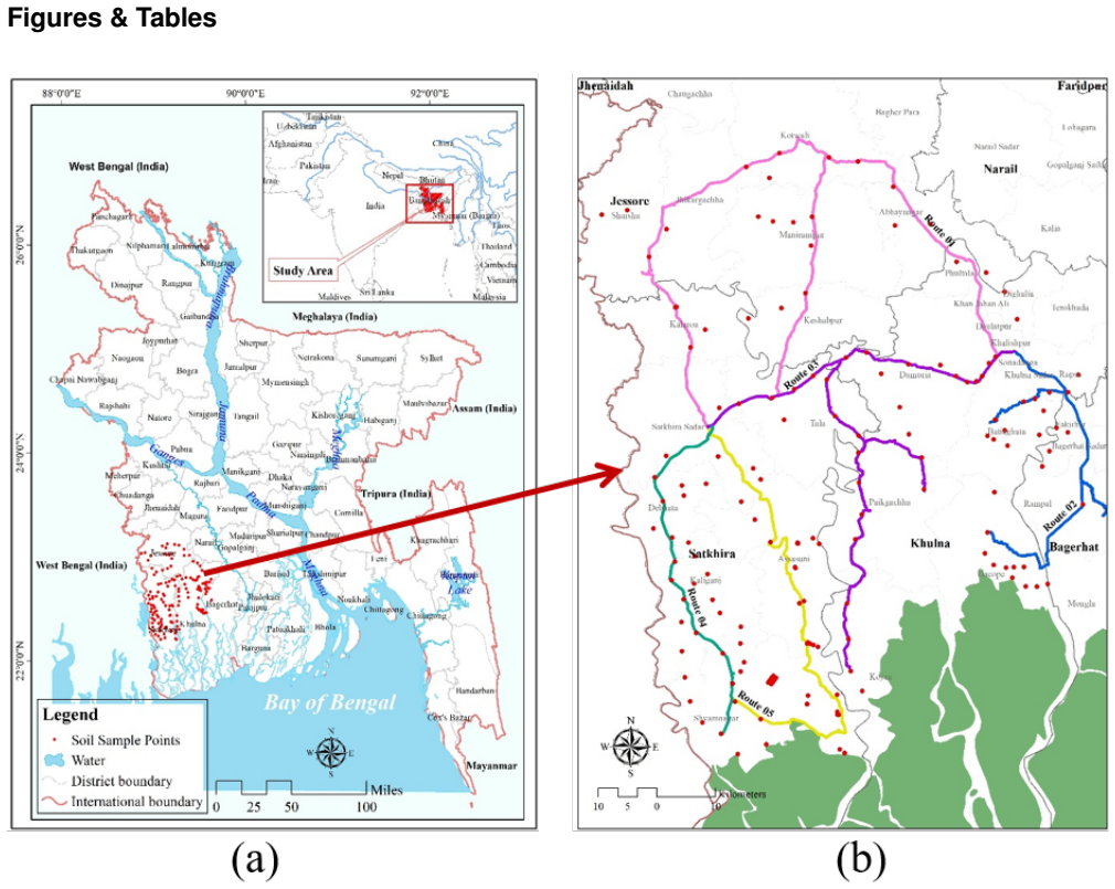
Food and Agriculture Organization of the United Nations. Standard operating procedure for soil electrical conductivity soil/water, 1:5 (2021). Accessed: 20-02-2024. 7/16 Figures & Tables Figure 1. (a) Location of study area in context of Bangladesh; (b) soil sample points and ...
2021
Reviewed August 10, 2026 · model on record in the stance chip above.
Discussion (0). Continue with ORCID to comment.