REVIEW 5 major objections 5 minor 63 references
Controllable Satellite-to-Street-View Synthesis with Precise Pose Alignment and Zero-Shot Environmental Control
T0 review · 5 major / 5 minor · reviewed 2026-08-09 · deepseek-v4-flash
Pith's one-line read A satellite-to-street-view diffusion pipeline uses an Iterative Homography Adjustment during denoising to keep generated ground images aligned with the satellite pose, and CLIP text guidance to control weather and lighting at inference.
desk verdict Integrates useful geometric conditioning for satellite-to-street-view diffusion, but the pose-alignment gains are marginal and the environmental control evaluation is partly circular; worth a careful review, not desk rejection. read the letter →
The pith
A machine-rendered reading of the paper's core claim, the machinery that carries it, and where it could break.
The reading
What carries the argument
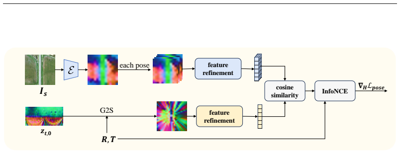
The load-bearing mechanism is the Iterative Homography Adjustment (IHA), a pose-correction loop inserted into DDIM sampling. At each early denoising step the model denoises the current latent to an estimate $z_{t,0}$, projects it onto an overhead view under a ground-plane assumption, computes an InfoNCE loss between ground-level features and satellite features at several candidate poses, and updates a homography matrix $H$ by gradient descent on that loss; the updated $H$ warps the latent via $z_t \otimes \mathrm{grid}(H)$. A second named component, Geometric Cross-Attention (GCA), replaces the usual cross-attention in the denoising U-Net: for each ground pixel it samples satellite features along $N=8$ reference height planes $h_i$ with learned offsets $\Delta h_i$ and softmax attention weights $A_i$, aggregating features as $\mathrm{GCA}(Q,V)=\sum_i A_i\,(V \otimes P(u_g,v_g,h_i+\Delta h_i))$. Together they inject explicit camera geometry into generation, while CLIP-text guidance supplies environmental control without retraining.
What would settle it
Take a test subset with tall buildings and strong parallax, generate the same scenes with and without IHA under identical noise, and measure lateral, longitudinal, and azimuth errors using a cross-view pose estimator; if IHA does not reduce those errors on that subset, the claim that a latent-space homography corrects pose is not supported.
Extended reading notes
Core claim
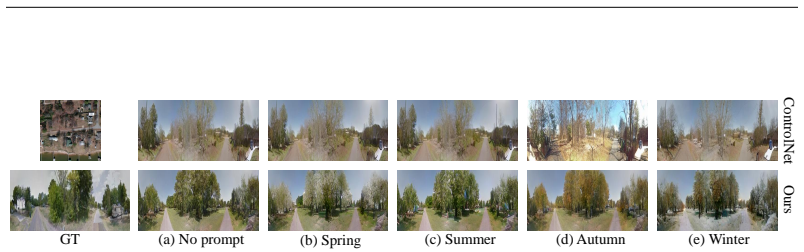
On the paper's own terms, the discovery is that both remaining bottlenecks in satellite-to-street-view synthesis—pose alignment and environmental diversity—can be handled at inference time rather than by new training data or heavy 3D reconstruction. The Geometric Cross-Attention module projects ground-pixel queries onto satellite feature maps through a set of reference height planes with learned offsets and attention weights, giving the diffusion model explicit geometric correspondences. The Iterative Homography Adjustment then computes a homography that best aligns the current denoised latent to the satellite at the requested camera pose, using a contrastive InfoNCE loss over candidate poses, and applies that homography to the latent at each of the first forty sampling steps. Environmental control is achieved separately by CLIP guidance: the denoised latent is split into patches, each patch is scored against a text prompt, and the gradient of that score steers sampling. The paper reports that this pipeline beats prior satellite-to-street-view generators on structural, perceptual, semantic, and depth similarity, and that the generated images improve cross-view localization when used as training augmentation.
Load-bearing premise
The method assumes that a single flat-plane image warp applied to the internal noise representation of the generated image can correct camera-pose error, which is exact only for flat ground and approximate for buildings and elevated structures.
Editorial extensions
If this is right
- Street-view images generated from satellite imagery can keep a specified camera pose throughout generation, and pose errors appearing in the diffusion output are corrected during sampling rather than requiring retraining.
- Environmental conditions such as seasons, weather, and lighting can be changed at inference time with text prompts, without paired weather-labelled training data.
- The same framework works for panoramic ground images from CVUSA and VIGOR and for narrow-field-of-view camera images from KITTI.
- Generated street-view data can serve as augmentation for training a cross-view vehicle localizer, and the paper reports it improves localization accuracy on KITTI.
- Pixel-level metrics like RMSE and PSNR are not appropriate for comparing satellite-to-street-view synthesis; semantic, depth, and structural metrics should be used instead.
Reading between the lines
- Because IHA operates purely on the latent code with a learned gradient on a homography, the same correction loop could in principle be attached to any latent diffusion model conditioned on a top-down reference; the paper only demonstrates this for its own finetuned U-Net, so this generalization is an inference, not a claim.
- The paper's own limitations section admits that building facades and lane markings are imperfect, which points to the discrete-height-plus-homography geometry as the part most likely to bend under strong parallax; testing on high-rise scenes would show how far the claim extends.
- The zero-shot environment control could likely be pushed toward finer attributes such as snow on roofs, wet asphalt, or sunset color temperature by using a stronger vision-language model or per-pixel CLIP features; the paper demonstrates only coarse season and weather prompts, so this is a forward extension rather than a demonstrated capability.
Editorial analysis
A structured set of objections, weighed in public.
Referee Report
Summary. The paper proposes a latent diffusion framework for satellite-to-street-view synthesis. The two main contributions are an Iterative Homography Adjustment (IHA) scheme that updates a 3x3 homography in latent space during DDIM sampling to correct pose misalignment, and a Text-guided Zero-shot Environmental Control (ZoEC) strategy that uses CLIP-based classifier guidance to vary illumination and weather without retraining. A Geometric Cross-Attention (GCA) mechanism is also introduced to condition the diffusion model on satellite geometry. The method is evaluated on CVUSA, VIGOR, and KITTI with several image-quality metrics, a cross-view pose-estimation metric, and a data-augmentation experiment for cross-view localization.
Significance. If the method holds, it addresses a practically important problem: generating geometrically consistent street-view images from satellite inputs while allowing zero-shot control of environmental conditions. The paper has notable strengths: it evaluates pose alignment with an external cross-view pose estimator (CCVPE), it demonstrates a downstream application in data augmentation for cross-view localization (Appendix A.2), and it introduces a geometric conditioning mechanism that goes beyond implicit conditions. The central ideas are plausible and the experimental scope is substantial. However, the quantitative support for the pose-alignment claim is thin (small, partly inconsistent gains in Table 3), the environmental-control evaluation is partially circular because the reported CLIP score is the optimized objective, and the latent-space homography correction rests on an unverified equivariance assumption. These issues are fixable, but they affect load-bearing claims.
major comments (5)
- [§5.3, Table 3] The pose-alignment claim is supported by small and partly inconsistent differences: average distance changes from 10.74 to 10.51 with full pipeline (a 2.1% relative change), average angle from 17.60 to 17.14, but median angle worsens for LDM+IHA (6.64 to 6.73) and longitudinal @d=1 worsens for LDM+IHA (15.35 to 15.77). No error bars, significance tests, or multiple-seed variance are reported. Because the abstract claims that IHA 'effectively addresses pose misalignment,' Table 3 needs a stronger effect size or a proper statistical analysis to establish that the gains are not noise.
- [§4.2, Algorithm 1] IHA updates H by backpropagating the InfoNCE loss through the warped latent z_t ⊗ grid(H). For this correction to transfer to the decoded street-view image, the latent space must be approximately equivariant to image-space homographies, i.e., D(H·z) ≈ H·D(z). No evidence for this equivariance is provided. If it fails, the gradient of L_pose with respect to H may reduce the latent loss without correctly fixing the pose of the decoded image. Please add a direct equivariance check (comparing D(warp(z)) and warp(D(z)) on a set of generated samples) and/or evaluate pose metrics on the decoded images after applying IHA in latent space versus after applying H in image space.
- [§4.3, Table 4] The environmental-control evaluation is partially circular. L_text in Eq. (8) is defined as 1 minus the mean CLIP cosine similarity between patches of z_{t,0} and the text c_text, and Table 4 reports the same CLIP cosine similarity as 'Clip Score' as evidence of environmental alignment. This score is an optimization objective, not an independent metric. The BLIP score is a useful step, but the authors should report at least one additional metric that is not directly optimized, such as a human evaluation, a separate vision-language model, or a classifier trained on weather/season labels.
- [Appendix A.4] The derivation of the guided-sampling formula contains a variable mismatch: Eq. (11) writes p(z_{t-1}|g_pose, g_text) = C p(g_pose, g_text | z_t) p(z_t), mixing z_{t-1} on the left with z_t on the right. The subsequent independence assumption p(g_pose, g_text | z_t) = p(g_pose | z_t) p(g_text | z_t) is also unstated and does not generally hold if pose and environment are correlated in the image. Please correct the derivation to a consistent Bayes update and explicitly state the independence approximation.
- [§4.2, last paragraph] The sentence 'During the inference stage, both the denoising Unet and the Homography Adjustment network are trained' contradicts the described inference-time optimization of H and the earlier statement that the correction is applied through H updates. If the Homography Adjustment network's weights are actually trained at inference, the paper must explain where the supervision comes from and how this is consistent with the zero-shot description; otherwise the method cannot be reproduced from the text.
minor comments (5)
- [§5.1] The height hypotheses list {−3,−2,−1,1,2,3,4,5} is given without a sign convention relative to the ground plane or a sensitivity study; the sentence 'This constitutes an empirical setup' is too vague to guide reimplementation.
- [Algorithm 1] The comment 'H is a diagonal matrix of ones' is ambiguous or incorrect: a 3x3 homography initialized for identity should be the identity matrix, not a diagonal matrix of ones (which would have ones on the diagonal and zeros elsewhere; that is the identity only if the off-diagonal zeros are intended). Please clarify.
- [Figure 2] The notation in Figure 2 is cluttered: the labels 'each patch', 'Pose Correction', and 'Env Control' are difficult to read, and the relationship between the 'Warp' boxes and the algorithm steps is unclear.
- [References] Rombach et al. 2022a and 2022b are the same CVPR paper; please consolidate the duplicate reference.
- [Reproducibility] The paper does not state whether code or trained models will be released; sharing code would significantly help reproducibility given the number of hyperparameters (γ, λ, τ, the height set, the IHA window, and the patch partition).
Circularity Check
Partial circularity in ZoEC evaluation: Eq. 8's CLIP guidance objective is reported as Table 4's Clip Score; pose alignment is independently evaluated.
-
fitted input called prediction
[Sec. 4.3 (Eq. 8); Sec. 4.4 (text-similarity metric); Table 4]
""Ltext(zt, ctext) = 1− 1/N Σ sim(CLIP(z^l_{t,0}), CLIP(ctext))" (Eq. 8). "Finally, for text similarity, we compute the similarity of Clip Radford et al. (2021) features for evaluation" (Sec. 4.4). "Table 4: The similarity between generated images and environmental text prompt.""
The ZoEC guidance in Eq. 8 directly maximizes CLIP cosine similarity between generated latent patches and the text prompt. The headline quantitative evidence for environmental control, Table 4's Clip Score, is the same CLIP cosine similarity evaluated on the generated images. Therefore the high Clip Score is partly forced by the sampling objective rather than by independent verification that the scene actually displays the requested season. The Blip Score and qualitative figures are separate evidence, so the circularity is partial and confined to the CLIP-based evaluation.
full rationale
Score 4 reflects one partial circularity. The paper's pose-alignment claim is not circular: IHA adjusts a latent homography by minimizing an InfoNCE pose loss, but the Table 3 evaluation uses the external CCVPE pose estimator, so the reported pose metrics are not the training objective. The GCA projection and the Appendix A.4 classifier-guidance derivation are standard reformulations with stated assumptions and do not smuggle in the target result. The self-citations to Shi et al. are for projection/localization components and are not used to forbid alternatives or justify a uniqueness claim. The remaining issue is the environmental-control evaluation: Eq. 8 optimizes CLIP cosine similarity and Table 4 reports CLIP cosine similarity, so that part of the evidence reduces by construction. This does not invalidate the whole paper because qualitative results and the BLIP recall metric are independent, and the pose half is externally validated; hence 4 rather than 6+.
Assumptions & free parameters
free parameters (6)
- GCA reference height hypotheses h_i =
{-3, -2, -1, 1, 2, 3, 4, 5}, N=8
- Text guidance strength gamma =
not reported
- Pose guidance strength lambda =
not reported
- InfoNCE temperature tau =
not reported
- IHA application window =
first 40 of 50 DDIM steps
- Text loss patch partition =
not reported
assumptions (4)
- standard math Bayes factorization and independence of pose and text guidance in Appendix A.4
- domain assumption Discrete height-plane scene representation with learned offsets captures 3D geometry
- ad hoc to paper Homography warping of the latent z_t approximates image-space homography correction
- domain assumption CLIP cosine similarity is a sufficient reward for weather and season control
Cite this review
Pith. "Pith review of Controllable Satellite-to-Street-View Synthesis with Precise Pose Alignment and Zero-Shot Environmental Control." pith.science (2026). https://pith.science/paper/M3HDMLV3
@misc{pith2026250203498,
  author       = {Pith},
  title        = {Pith review of: Controllable Satellite-to-Street-View Synthesis with Precise Pose Alignment and Zero-Shot Environmental Control},
  year         = {2026},
  howpublished = {\url{https://pith.science/paper/M3HDMLV3}},
  note         = {Machine review of arXiv:2502.03498}
}
read the original abstract
Generating street-view images from satellite imagery is a challenging task, particularly in maintaining accurate pose alignment and incorporating diverse environmental conditions. While diffusion models have shown promise in generative tasks, their ability to maintain strict pose alignment throughout the diffusion process is limited. In this paper, we propose a novel Iterative Homography Adjustment (IHA) scheme applied during the denoising process, which effectively addresses pose misalignment and ensures spatial consistency in the generated street-view images. Additionally, currently, available datasets for satellite-to-street-view generation are limited in their diversity of illumination and weather conditions, thereby restricting the generalizability of the generated outputs. To mitigate this, we introduce a text-guided illumination and weather-controlled sampling strategy that enables fine-grained control over the environmental factors. Extensive quantitative and qualitative evaluations demonstrate that our approach significantly improves pose accuracy and enhances the diversity and realism of generated street-view images, setting a new benchmark for satellite-to-street-view generation tasks.
Figures


Figures from the paper (14 more)




Reference graph
Works this paper leans on
-
[1]
A-bdd: Leveraging data augmentations for safe autonomous driving in adverse weather and lighting
Felix Assion, Florens Gressner, Nitin Augustine, Jona Klemenc, Ahmed Hammam, Alexandre Krattinger, Holger Trittenbach, and Sascha Riemer. A-bdd: Leveraging data augmentations for safe autonomous driving in adverse weather and lighting. arXiv preprint arXiv:2408.06071, 2024
arXiv 2024
-
[2]
Blended diffusion for text-driven editing of natural images
Omri Avrahami, Dani Lischinski, and Ohad Fried. Blended diffusion for text-driven editing of natural images. In Proceedings of the IEEE/CVF conference on computer vision and pattern recognition, pp.\ 18208--18218, 2022
work page 2022
-
[3]
Instructpix2pix: Learning to follow image editing instructions
Tim Brooks, Aleksander Holynski, and Alexei A Efros. Instructpix2pix: Learning to follow image editing instructions. In Proceedings of the IEEE/CVF Conference on Computer Vision and Pattern Recognition, pp.\ 18392--18402, 2023
work page 2023
-
[4]
Emerging properties in self-supervised vision transformers
Mathilde Caron, Hugo Touvron, Ishan Misra, Herv \'e J \'e gou, Julien Mairal, Piotr Bojanowski, and Armand Joulin. Emerging properties in self-supervised vision transformers. In Proceedings of the IEEE/CVF international conference on computer vision, pp.\ 9650--9660, 2021
work page 2021
-
[5]
Tac-gan-text conditioned auxiliary classifier generative adversarial network
Ayushman Dash, John Cristian Borges Gamboa, Sheraz Ahmed, Marcus Liwicki, and Muhammad Zeshan Afzal. Tac-gan-text conditioned auxiliary classifier generative adversarial network. arXiv preprint arXiv:1703.06412, 2017
arXiv 2017
-
[6]
Diffusion models beat gans on image synthesis
Prafulla Dhariwal and Alexander Nichol. Diffusion models beat gans on image synthesis. Advances in neural information processing systems, 34: 0 8780--8794, 2021
2021
-
[7]
Scp-diff: Photo-realistic semantic image synthesis with spatial-categorical joint prior
Huan-ang Gao, Mingju Gao, Jiaju Li, Wenyi Li, Rong Zhi, Hao Tang, and Hao Zhao. Scp-diff: Photo-realistic semantic image synthesis with spatial-categorical joint prior. arXiv preprint arXiv:2403.09638, 2024 a
arXiv 2024
-
[8]
Cat3d: Create anything in 3d with multi-view diffusion models
Ruiqi Gao, Aleksander Holynski, Philipp Henzler, Arthur Brussee, Ricardo Martin-Brualla, Pratul Srinivasan, Jonathan T Barron, and Ben Poole. Cat3d: Create anything in 3d with multi-view diffusion models. arXiv preprint arXiv:2405.10314, 2024 b
arXiv 2024
Show all 63 references
-
[9]
MagicDrive : Street view generation with diverse 3d geometry control
Ruiyuan Gao, Kai Chen, Enze Xie, Lanqing Hong, Zhenguo Li, Dit-Yan Yeung, and Qiang Xu. MagicDrive : Street view generation with diverse 3d geometry control. In International Conference on Learning Representations, 2024 c
2024
-
[10]
Vision meets robotics: The kitti dataset
Andreas Geiger, Philip Lenz, Christoph Stiller, and Raquel Urtasun. Vision meets robotics: The kitti dataset. The International Journal of Robotics Research, 32 0 (11): 0 1231--1237, 2013
2013
-
[11]
Squeezenet: Alexnet-level accuracy with 50x fewer parameters and< 0.5 mb model size
Forrest N Iandola. Squeezenet: Alexnet-level accuracy with 50x fewer parameters and< 0.5 mb model size. arXiv preprint arXiv:1602.07360, 2016
2016 arXiv
-
[12]
Image-to-image translation with conditional adversarial networks
Phillip Isola, Jun-Yan Zhu, Tinghui Zhou, and Alexei A Efros. Image-to-image translation with conditional adversarial networks. CVPR, 2017
2017
-
[13]
Segment anything
Alexander Kirillov, Eric Mintun, Nikhila Ravi, Hanzi Mao, Chloe Rolland, Laura Gustafson, Tete Xiao, Spencer Whitehead, Alexander C Berg, Wan-Yen Lo, et al. Segment anything. In Proceedings of the IEEE/CVF International Conference on Computer Vision, pp.\ 4015--4026, 2023
2023
-
[14]
Imagenet classification with deep convolutional neural networks
Alex Krizhevsky, Ilya Sutskever, and Geoffrey E Hinton. Imagenet classification with deep convolutional neural networks. Communications of the ACM, 60 0 (6): 0 84--90, 2017
2017
-
[15]
Slicematch: Geometry-guided aggregation for cross-view pose estimation
Ted de Vries Lentsch, Zimin Xia, Holger Caesar, and Julian FP Kooij. Slicematch: Geometry-guided aggregation for cross-view pose estimation. arXiv preprint arXiv:2211.14651, 2022
2022 arXiv
-
[16]
Blip: Bootstrapping language-image pre-training for unified vision-language understanding and generation
Junnan Li, Dongxu Li, Caiming Xiong, and Steven Hoi. Blip: Bootstrapping language-image pre-training for unified vision-language understanding and generation. In International conference on machine learning, pp.\ 12888--12900. PMLR, 2022
2022
-
[17]
Crossviewdiff: A cross-view diffusion model for satellite-to-street view synthesis
Weijia Li, Jun He, Junyan Ye, Huaping Zhong, Zhimeng Zheng, Zilong Huang, Dahua Lin, and Conghui He. Crossviewdiff: A cross-view diffusion model for satellite-to-street view synthesis. arXiv preprint arXiv:2408.14765, 2024 a
2024 arXiv
-
[18]
Drivingdiffusion: Layout-guided multi-view driving scene video generation with latent diffusion model
Xiaofan Li, Yifu Zhang, and Xiaoqing Ye. Drivingdiffusion: Layout-guided multi-view driving scene video generation with latent diffusion model. arXiv preprint arXiv:2310.07771, 2023 a
2023 arXiv
-
[19]
Gligen: Open-set grounded text-to-image generation
Yuheng Li, Haotian Liu, Qingyang Wu, Fangzhou Mu, Jianwei Yang, Jianfeng Gao, Chunyuan Li, and Yong Jae Lee. Gligen: Open-set grounded text-to-image generation. In Proceedings of the IEEE/CVF Conference on Computer Vision and Pattern Recognition, pp.\ 22511--22521, 2023 b
2023
-
[20]
Sat2vid: Street-view panoramic video synthesis from a single satellite image
Zuoyue Li, Zhenqiang Li, Zhaopeng Cui, Rongjun Qin, Marc Pollefeys, and Martin R Oswald. Sat2vid: Street-view panoramic video synthesis from a single satellite image. In Proceedings of the IEEE/CVF International Conference on Computer Vision, pp.\ 12436--12445, 2021
2021
-
[21]
Sat2scene: 3d urban scene generation from satellite images with diffusion
Zuoyue Li, Zhenqiang Li, Zhaopeng Cui, Marc Pollefeys, and Martin R Oswald. Sat2scene: 3d urban scene generation from satellite images with diffusion. In Proceedings of the IEEE/CVF Conference on Computer Vision and Pattern Recognition, pp.\ 7141--7150, 2024 b
2024
-
[22]
Visual instruction tuning
Haotian Liu, Chunyuan Li, Qingyang Wu, and Yong Jae Lee. Visual instruction tuning. Advances in neural information processing systems, 36, 2024
2024
-
[23]
Zero-1-to-3: Zero-shot one image to 3d object
Ruoshi Liu, Rundi Wu, Basile Van Hoorick, Pavel Tokmakov, Sergey Zakharov, and Carl Vondrick. Zero-1-to-3: Zero-shot one image to 3d object. In Proceedings of the IEEE/CVF international conference on computer vision, pp.\ 9298--9309, 2023
2023
-
[24]
Geometry-aware satellite-to-ground image synthesis for urban areas
Xiaohu Lu, Zuoyue Li, Zhaopeng Cui, Martin R Oswald, Marc Pollefeys, and Rongjun Qin. Geometry-aware satellite-to-ground image synthesis for urban areas. In Proceedings of the IEEE/CVF Conference on Computer Vision and Pattern Recognition, pp.\ 859--867, 2020
2020
-
[25]
Im-3d: Iterative multiview diffusion and reconstruction for high-quality 3d generation
Luke Melas-Kyriazi, Iro Laina, Christian Rupprecht, Natalia Neverova, Andrea Vedaldi, Oran Gafni, and Filippos Kokkinos. Im-3d: Iterative multiview diffusion and reconstruction for high-quality 3d generation. arXiv preprint arXiv:2402.08682, 2024
2024 arXiv
-
[26]
Representation learning with contrastive predictive coding
Aaron van den Oord, Yazhe Li, and Oriol Vinyals. Representation learning with contrastive predictive coding. arXiv preprint arXiv:1807.03748, 2018
2018 arXiv
-
[27]
Dreamfusion: Text-to-3d using 2d diffusion
Ben Poole, Ajay Jain, Jonathan T Barron, and Ben Mildenhall. Dreamfusion: Text-to-3d using 2d diffusion. arXiv preprint arXiv:2209.14988, 2022
2022 arXiv
-
[28]
Sat2density: Faithful density learning from satellite-ground image pairs
Ming Qian, Jincheng Xiong, Gui-Song Xia, and Nan Xue. Sat2density: Faithful density learning from satellite-ground image pairs. In Proceedings of the IEEE/CVF International Conference on Computer Vision, pp.\ 3683--3692, 2023
2023
-
[29]
Learning transferable visual models from natural language supervision
Alec Radford, Jong Wook Kim, Chris Hallacy, Aditya Ramesh, Gabriel Goh, Sandhini Agarwal, Girish Sastry, Amanda Askell, Pamela Mishkin, Jack Clark, et al. Learning transferable visual models from natural language supervision. In International conference on machine learning, pp...
2021
-
[30]
Cross-view image synthesis using conditional gans
Krishna Regmi and Ali Borji. Cross-view image synthesis using conditional gans. In Proceedings of the IEEE conference on Computer Vision and Pattern Recognition, pp.\ 3501--3510, 2018
2018
-
[31]
High-resolution image synthesis with latent diffusion models
Robin Rombach, Andreas Blattmann, Dominik Lorenz, Patrick Esser, and Bj\"orn Ommer. High-resolution image synthesis with latent diffusion models. In Proceedings of the IEEE/CVF Conference on Computer Vision and Pattern Recognition (CVPR), pp.\ 10684--10695, June 2022 a
2022
-
[32]
High-resolution image synthesis with latent diffusion models
Robin Rombach, Andreas Blattmann, Dominik Lorenz, Patrick Esser, and Bj \"o rn Ommer. High-resolution image synthesis with latent diffusion models. In Proceedings of the IEEE/CVF conference on computer vision and pattern recognition, pp.\ 10684--10695, 2022 b
2022
-
[33]
Dae-gan: Dynamic aspect-aware gan for text-to-image synthesis
Shulan Ruan, Yong Zhang, Kun Zhang, Yanbo Fan, Fan Tang, Qi Liu, and Enhong Chen. Dae-gan: Dynamic aspect-aware gan for text-to-image synthesis. In Proceedings of the IEEE/CVF international conference on computer vision, pp.\ 13960--13969, 2021
2021
-
[34]
Geosynth: Contextually-aware high-resolution satellite image synthesis
Srikumar Sastry, Subash Khanal, Aayush Dhakal, and Nathan Jacobs. Geosynth: Contextually-aware high-resolution satellite image synthesis. In Proceedings of the IEEE/CVF Conference on Computer Vision and Pattern Recognition, pp.\ 460--470, 2024
2024
-
[35]
Matching local self-similarities across images and videos
Eli Shechtman and Michal Irani. Matching local self-similarities across images and videos. In 2007 IEEE conference on computer vision and pattern recognition, pp.\ 1--8. IEEE, 2007
2007
-
[36]
Beyond cross-view image retrieval: Highly accurate vehicle localization using satellite image
Yujiao Shi and Hongdong Li. Beyond cross-view image retrieval: Highly accurate vehicle localization using satellite image. In Proceedings of the IEEE/CVF Conference on Computer Vision and Pattern Recognition, pp.\ 17010--17020, 2022
2022
-
[37]
Spatial-aware feature aggregation for image based cross-view geo-localization
Yujiao Shi, Liu Liu, Xin Yu, and Hongdong Li. Spatial-aware feature aggregation for image based cross-view geo-localization. Advances in Neural Information Processing Systems, 32, 2019
2019
-
[38]
Where am i looking at? joint location and orientation estimation by cross-view matching
Yujiao Shi, Xin Yu, Dylan Campbell, and Hongdong Li. Where am i looking at? joint location and orientation estimation by cross-view matching. In Proceedings of the IEEE/CVF Conference on Computer Vision and Pattern Recognition, pp.\ 4064--4072, 2020 a
2020
-
[39]
Optimal feature transport for cross-view image geo-localization
Yujiao Shi, Xin Yu, Liu Liu, Tong Zhang, and Hongdong Li. Optimal feature transport for cross-view image geo-localization. In Proceedings of the AAAI Conference on Artificial Intelligence, volume 34, pp.\ 11990--11997, 2020 b
2020
-
[40]
Geometry-guided street-view panorama synthesis from satellite imagery
Yujiao Shi, Dylan Campbell, Xin Yu, and Hongdong Li. Geometry-guided street-view panorama synthesis from satellite imagery. IEEE Transactions on Pattern Analysis and Machine Intelligence, 44 0 (12): 0 10009--10022, 2022 a
2022
-
[41]
Accurate 3-dof camera geo-localization via ground-to-satellite image matching
Yujiao Shi, Xin Yu, Liu Liu, Dylan Campbell, Piotr Koniusz, and Hongdong Li. Accurate 3-dof camera geo-localization via ground-to-satellite image matching. IEEE transactions on pattern analysis and machine intelligence, 45 0 (3): 0 2682--2697, 2022 b
2022
-
[42]
Cvlnet: Cross-view semantic correspondence learning for video-based camera localization
Yujiao Shi, Xin Yu, Shan Wang, and Hongdong Li. Cvlnet: Cross-view semantic correspondence learning for video-based camera localization. In Asian Conference on Computer Vision, pp.\ 123--141. Springer, 2022 c
2022
-
[43]
Boosting 3-dof ground-to-satellite camera localization accuracy via geometry-guided cross-view transformer
Yujiao Shi, Fei Wu, Akhil Perincherry, Ankit Vora, and Hongdong Li. Boosting 3-dof ground-to-satellite camera localization accuracy via geometry-guided cross-view transformer. In Proceedings of the IEEE/CVF International Conference on Computer Vision, pp.\ 21516--21526, 2023
2023
-
[44]
Weakly-supervised camera localization by ground-to-satellite image registration
Yujiao Shi, Hongdong Li, Akhil Perincherry, and Ankit Vora. Weakly-supervised camera localization by ground-to-satellite image registration. In European Conference on Computer Vision, pp.\ 39--57. Springer, 2025
2025
-
[45]
Score-based generative modeling through stochastic differential equations
Yang Song, Jascha Sohl-Dickstein, Diederik P Kingma, Abhishek Kumar, Stefano Ermon, and Ben Poole. Score-based generative modeling through stochastic differential equations. arXiv preprint arXiv:2011.13456, 2020
2011 arXiv
-
[46]
Learning dense flow field for highly-accurate cross-view camera localization
Zhenbo Song, Jianfeng Lu, Yujiao Shi, et al. Learning dense flow field for highly-accurate cross-view camera localization. Advances in Neural Information Processing Systems, 36, 2024
2024
-
[47]
Df-gan: A simple and effective baseline for text-to-image synthesis
Ming Tao, Hao Tang, Fei Wu, Xiao-Yuan Jing, Bing-Kun Bao, and Changsheng Xu. Df-gan: A simple and effective baseline for text-to-image synthesis. In Proceedings of the IEEE/CVF conference on computer vision and pattern recognition, pp.\ 16515--16525, 2022
2022
-
[48]
Splicing vit features for semantic appearance transfer
Narek Tumanyan, Omer Bar-Tal, Shai Bagon, and Tali Dekel. Splicing vit features for semantic appearance transfer. In Proceedings of the IEEE/CVF Conference on Computer Vision and Pattern Recognition, pp.\ 10748--10757, 2022
2022
-
[49]
Cross-view panorama image synthesis
Songsong Wu, Hao Tang, Xiao-Yuan Jing, Haifeng Zhao, Jianjun Qian, Nicu Sebe, and Yan Yan. Cross-view panorama image synthesis. IEEE Transactions on Multimedia, 25: 0 3546--3559, 2022
2022
-
[50]
Visual cross-view metric localization with dense uncertainty estimates
Zimin Xia, Olaf Booij, Marco Manfredi, and Julian FP Kooij. Visual cross-view metric localization with dense uncertainty estimates. In European Conference on Computer Vision, pp.\ 90--106. Springer, 2022
2022
-
[51]
Convolutional cross-view pose estimation
Zimin Xia, Olaf Booij, and Julian FP Kooij. Convolutional cross-view pose estimation. IEEE Transactions on Pattern Analysis and Machine Intelligence, 2023
2023
-
[52]
Adapting fine-grained cross-view localization to areas without fine ground truth
Zimin Xia, Yujiao Shi, Hongdong Li, and Julian FP Kooij. Adapting fine-grained cross-view localization to areas without fine ground truth. In European Conference on Computer Vision, pp.\ 397--415. Springer, 2025
2025
-
[53]
Geospecific view generation--geometry-context aware high-resolution ground view inference from satellite views
Ningli Xu and Rongjun Qin. Geospecific view generation--geometry-context aware high-resolution ground view inference from satellite views. arXiv preprint arXiv:2407.08061, 2024
2024 arXiv
-
[54]
Chinese clip: Contrastive vision-language pretraining in chinese
An Yang, Junshu Pan, Junyang Lin, Rui Men, Yichang Zhang, Jingren Zhou, and Chang Zhou. Chinese clip: Contrastive vision-language pretraining in chinese. arXiv preprint arXiv:2211.01335, 2022
2022 arXiv
-
[55]
Depth anything: Unleashing the power of large-scale unlabeled data
Lihe Yang, Bingyi Kang, Zilong Huang, Xiaogang Xu, Jiashi Feng, and Hengshuang Zhao. Depth anything: Unleashing the power of large-scale unlabeled data. In Proceedings of the IEEE/CVF Conference on Computer Vision and Pattern Recognition, pp.\ 10371--10381, 2024
2024
-
[56]
Predicting ground-level scene layout from aerial imagery
Menghua Zhai, Zachary Bessinger, Scott Workman, and Nathan Jacobs. Predicting ground-level scene layout from aerial imagery. In Proceedings of the IEEE Conference on Computer Vision and Pattern Recognition, pp.\ 867--875, 2017
2017
-
[57]
Adding conditional control to text-to-image diffusion models
Lvmin Zhang, Anyi Rao, and Maneesh Agrawala. Adding conditional control to text-to-image diffusion models. In Proceedings of the IEEE/CVF International Conference on Computer Vision, pp.\ 3836--3847, 2023
2023
-
[58]
The unreasonable effectiveness of deep features as a perceptual metric
Richard Zhang, Phillip Isola, Alexei A Efros, Eli Shechtman, and Oliver Wang. The unreasonable effectiveness of deep features as a perceptual metric. In Proceedings of the IEEE conference on computer vision and pattern recognition, pp.\ 586--595, 2018
2018
-
[59]
Vigor: Cross-view image geo-localization beyond one-to-one retrieval
Sijie Zhu, Taojiannan Yang, and Chen Chen. Vigor: Cross-view image geo-localization beyond one-to-one retrieval. In Proceedings of the IEEE/CVF Conference on Computer Vision and Pattern Recognition, pp.\ 3640--3649, 2021
2021
-
[60]
write newline
" write newline "" before.all 'output.state := FUNCTION n.dashify 't := "" t empty not t #1 #1 substring "-" = t #1 #2 substring "--" = not "--" * t #2 global.max substring 't := t #1 #1 substring "-" = "-" * t #2 global.max substring 't := while if t #1 #1 substring * t #2 gl...
-
[61]
@esa (Ref
\@ifxundefined[1] #1\@undefined \@firstoftwo \@secondoftwo \@ifnum[1] #1 \@firstoftwo \@secondoftwo \@ifx[1] #1 \@firstoftwo \@secondoftwo [2] @ #1 \@temptokena #2 #1 @ \@temptokena \@ifclassloaded agu2001 natbib The agu2001 class already includes natbib coding, so you should ...
-
[62]
\@lbibitem[] @bibitem@first@sw\@secondoftwo \@lbibitem[#1]#2 \@extra@b@citeb \@ifundefined br@#2\@extra@b@citeb \@namedef br@#2 \@nameuse br@#2\@extra@b@citeb \@ifundefined b@#2\@extra@b@citeb @num @parse #2 @tmp #1 NAT@b@open@#2 NAT@b@shut@#2 \@ifnum @merge>\@ne @bibitem@firs...
-
[63]
@open @close @open @close and [1] URL: #1 \@ifundefined chapter * \@mkboth \@ifxundefined @sectionbib * \@mkboth * \@mkboth\@gobbletwo \@ifclassloaded amsart * \@ifclassloaded amsbook * \@ifxundefined @heading @heading NAT@ctr thebibliography [1] @ \@biblabel @NAT@ctr \@bibset...
Reviewed August 9, 2026 · model on record in the stance chip above.
Discussion (0). Continue with ORCID to comment.