RICH-SLAM: Radar SLAM with Incremental and Continuous Hilbert Mapping
Pith reviewed 2026-06-27 00:50 UTC · model grok-4.3
The pith
RICH-SLAM builds continuous occupancy maps from sparse radar measurements with an incremental Hilbert-space Gaussian process.
A machine-rendered reading of the paper's core claim, the machinery that carries it, and where it could break.
Core claim
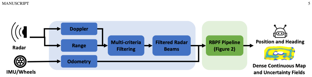
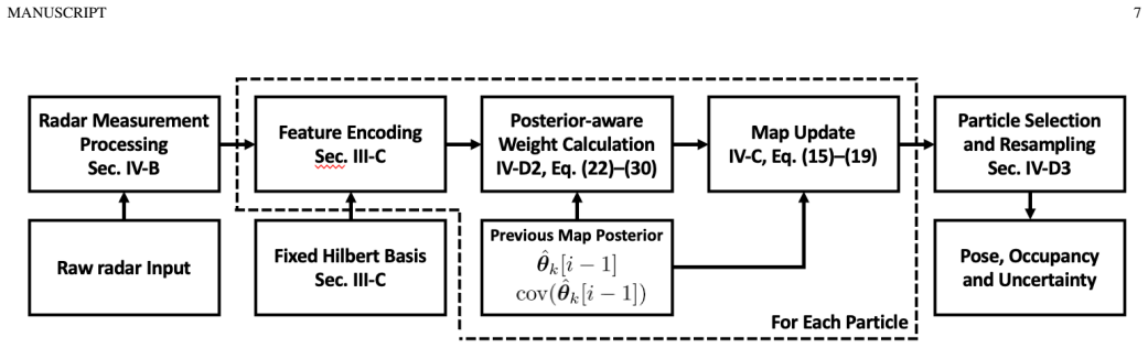
RICH-SLAM employs a Rao-Blackwellized particle filter-based back end that combines particle filtering for pose estimation and Kalman filtering for map updates, together with an incremental Hilbert-space reduced-rank Gaussian process mapping strategy and a posterior-aware particle weighting scheme, to construct continuous and uncertainty-aware map representations from sparse radar inputs.
What carries the argument
incremental Hilbert-space reduced-rank Gaussian process mapping strategy, which produces continuous and uncertainty-aware occupancy maps from sparse radar measurements
If this is right
- Continuous occupancy maps are constructed directly from sparse radar measurements.
- Uncertainty-aware planning becomes feasible for mobile robots using the map representations.
- Likelihood evaluation gains robustness from using the full posterior distribution of map parameters.
- Map consistency is maintained across frames despite radar sparsity and noise.
Where Pith is reading between the lines
- The same mapping approach could be tested on other sparse range sensors in low-visibility settings.
- The uncertainty output might integrate with existing planners to reduce collision risk in adverse conditions.
- Extension to multi-robot scenarios could be explored by sharing the continuous map parameters.
Load-bearing premise
The incremental Hilbert-space reduced-rank Gaussian process mapping strategy enables continuous and uncertainty-aware map representations given sparse radar inputs.
What would settle it
A test on the ColoRadar dataset showing that the produced maps lack continuity or that uncertainty estimates do not yield better planning outcomes than discrete map baselines would falsify the claim.
Figures
read the original abstract
Simultaneous localization and mapping using radar sensors has gained increasing attention due to radar's inherent robustness to adverse weather and lighting conditions. However, radar measurements are characteristically sparse and noisy compared to LiDAR and visual data, posing significant challenges in achieving dense, continuous, and consistent map representations. In this paper, we present RICH-SLAM, a radar SLAM framework designed to address these challenges. Our approach features a Rao-Blackwellized particle filter-based back end that employs particle filtering for pose estimation and Kalman filtering for map updates. We propose an incremental Hilbert-space reduced-rank Gaussian process mapping strategy that enables continuous and uncertainty-aware map representations given sparse radar inputs. We further introduce a posterior-aware particle weighting scheme that leverages the full posterior distribution of map parameters for more robust likelihood evaluation. Experiments on self-collected and public ColoRadar datasets show that RICH-SLAM constructs continuous occupancy maps from sparse radar measurements and supports uncertainty-aware planning for mobile robots.
Editorial analysis
A structured set of objections, weighed in public.
Referee Report
Summary. The manuscript presents RICH-SLAM, a radar SLAM system whose backend is a Rao-Blackwellized particle filter that performs pose estimation via particle filtering and map updates via Kalman filtering. The core technical contribution is an incremental Hilbert-space reduced-rank Gaussian process occupancy mapping method intended to produce continuous, uncertainty-aware maps from sparse radar returns; a posterior-aware particle weighting scheme is also introduced. Experiments on a self-collected dataset and the public ColoRadar dataset are stated to demonstrate that the system constructs continuous occupancy maps and enables uncertainty-aware planning.
Significance. If the experimental claims are substantiated, the work would supply a practical route to dense, continuous radar maps that remain uncertainty-aware, which is valuable for robot navigation under adverse weather or lighting where LiDAR and vision fail. The incremental reduced-rank GP formulation is a standard technique that, if shown to scale in the radar setting, could be adopted more widely for real-time mapping.
major comments (1)
- [Abstract] Abstract: the claim that 'experiments ... show that RICH-SLAM constructs continuous occupancy maps' is unsupported because the abstract (and the supplied text) contains no quantitative metrics, baselines, error statistics, or ablation results. Without these data the central assertion that the incremental Hilbert-space GP delivers continuous and uncertainty-aware representations from sparse inputs cannot be evaluated.
minor comments (1)
- The integration of the Rao-Blackwellized particle filter with the Kalman map update is described only at a high level; a concrete statement of the measurement model and the exact form of the reduced-rank GP kernel would improve reproducibility.
Simulated Author's Rebuttal
We thank the referee for their feedback on the manuscript. We address the single major comment below.
read point-by-point responses
-
Referee: [Abstract] Abstract: the claim that 'experiments ... show that RICH-SLAM constructs continuous occupancy maps' is unsupported because the abstract (and the supplied text) contains no quantitative metrics, baselines, error statistics, or ablation results. Without these data the central assertion that the incremental Hilbert-space GP delivers continuous and uncertainty-aware representations from sparse inputs cannot be evaluated.
Authors: We agree that the abstract would be strengthened by including quantitative support for its claims. The experiments section reports specific metrics on the ColoRadar and self-collected datasets, including mapping continuity measures, uncertainty calibration statistics, and comparisons against baseline radar mapping methods. To address the concern, we will revise the abstract to incorporate key quantitative results (e.g., reported error reductions and planning success rates) while preserving its concise nature. This change will make the central assertions directly substantiated within the abstract. revision: yes
Circularity Check
No significant circularity; derivation is self-contained
full rationale
The abstract and supplied description present a Rao-Blackwellized particle filter backend paired with an incremental reduced-rank Hilbert-space Gaussian process for occupancy mapping. These are standard, externally documented techniques for sparse sensor mapping and SLAM; the central claim (continuous uncertainty-aware maps from radar) follows directly from the stated components without any quoted reduction of a prediction to a fitted input, self-definition of a quantity in terms of itself, or load-bearing self-citation chain. No equations or derivation steps are exhibited that collapse by construction to the inputs. This is the expected honest non-finding for a methods paper whose core contributions are algorithmic combinations of established filters and GPs.
Axiom & Free-Parameter Ledger
Reference graph
Works this paper leans on
-
[1]
A new wave in robotics: Survey on recent mmwave radar applications in robotics,
K. Harlow, H. Jang, T. D. Barfoot, A. Kim, and C. Heckman, “A new wave in robotics: Survey on recent mmwave radar applications in robotics,”IEEE Transactions on Robotics, 2024
2024
-
[2]
Radar-inertial ego-velocity estimation for visually degraded environments,
A. Kramer, C. Stahoviak, A. Santamaria-Navarro, A.-a. Agha- mohammadi, and C. Heckman, “Radar-inertial ego-velocity estimation for visually degraded environments,” in2020 IEEE International Con- ference on Robotics and Automation (ICRA), 2020, pp. 5739–5746
2020
-
[3]
Less is more: Physical-enhanced radar-inertial odometry,
Q. Huang, Y . Liang, Z. Qiao, S. Shen, and H. Yin, “Less is more: Physical-enhanced radar-inertial odometry,” in2024 IEEE International Conference on Robotics and Automation (ICRA). IEEE, 2024, pp. 15 966–15 972
2024
-
[4]
Incorporating point uncertainty in radar SLAM,
Y . Xu, Q. Huang, S. Shen, and H. Yin, “Incorporating point uncertainty in radar SLAM,”IEEE Robotics and Automation Letters, 2025
2025
-
[5]
Dro: Doppler-aware direct radar odometry,
C. L. Gentil, L. Brizi, D. Lisus, X. Qiao, G. Grisetti, and T. D. Barfoot, “Dro: Doppler-aware direct radar odometry,”arXiv preprint arXiv:2504.20339, 2025
arXiv 2025
-
[6]
Siegwart, I
R. Siegwart, I. R. Nourbakhsh, and D. Scaramuzza,Introduction to autonomous mobile robots. MIT press, 2011
2011
-
[7]
A review of point cloud registration algorithms for mobile robotics,
F. Pomerleau, F. Colas, R. Siegwartet al., “A review of point cloud registration algorithms for mobile robotics,”Foundations and Trends® in Robotics, vol. 4, no. 1, pp. 1–104, 2015
2015
-
[8]
VINS-Mono: A robust and versatile monoc- ular visual-inertial state estimator,
T. Qin, P. Li, and S. Shen, “VINS-Mono: A robust and versatile monoc- ular visual-inertial state estimator,”IEEE Transactions on Robotics, vol. 34, no. 4, pp. 1004–1020, 2018
2018
-
[9]
Do we need scan-matching in radar odometry?
V . Kubelka, E. Fritz, and M. Magnusson, “Do we need scan-matching in radar odometry?” in2024 IEEE International Conference on Robotics and Automation (ICRA). IEEE, 2024, pp. 13 710–13 716
2024
-
[10]
A tutorial on graph-based SLAM,
G. Grisetti, R. K ¨ummerle, C. Stachniss, and W. Burgard, “A tutorial on graph-based SLAM,”IEEE Intelligent Transportation Systems Mag- azine, vol. 2, no. 4, pp. 31–43, 2011
2011
-
[11]
FastSLAM 2.0: An improved particle filtering algorithm for simultaneous localization and mapping that provably converges,
M. Montemerlo, S. Thrun, D. Koller, B. Wegbreitet al., “FastSLAM 2.0: An improved particle filtering algorithm for simultaneous localization and mapping that provably converges,” inIJCAI, vol. 3. Citeseer, 2003, pp. 1151–1156
2003
-
[12]
Improving grid-based SLAM with Rao-Blackwellized particle filters by adaptive proposals and selective resampling,
G. Grisetti, C. Stachniss, and W. Burgard, “Improving grid-based SLAM with Rao-Blackwellized particle filters by adaptive proposals and selective resampling,” inProceedings of the 2005 IEEE International Conference on Robotics and Automation. IEEE, 2005, pp. 2432–2437
2005
-
[13]
Improved techniques for grid mapping with Rao-blackwellized particle filters,
——, “Improved techniques for grid mapping with Rao-blackwellized particle filters,”IEEE Transactions on Robotics, vol. 23, no. 1, pp. 34– 46, 2007
2007
-
[14]
Contextual occupancy maps using Gaussian processes,
S. O’Callaghan, F. T. Ramos, and H. Durrant-Whyte, “Contextual occupancy maps using Gaussian processes,” in2009 IEEE International Conference on Robotics and Automation. IEEE, 2009, pp. 1054–1060
2009
-
[15]
Hilbert maps: Scalable continuous occupancy mapping with stochastic gradient descent,
F. Ramos and L. Ott, “Hilbert maps: Scalable continuous occupancy mapping with stochastic gradient descent,”The International Journal of Robotics Research, vol. 35, no. 14, pp. 1717–1730, 2016
2016
-
[16]
Hilbert space methods for reduced-rank Gaussian process regression,
A. Solin and S. S ¨arkk¨a, “Hilbert space methods for reduced-rank Gaussian process regression,”Statistics and Computing, vol. 30, no. 2, pp. 419–446, 2020
2020
-
[17]
Particle filter localization on continuous occupancy maps,
A. Y . Hata, D. F. Wolf, and F. T. Ramos, “Particle filter localization on continuous occupancy maps,” inInternational symposium on exper- imental robotics. Springer, 2016, pp. 742–751
2016
-
[18]
H-slam: Rao-blackwellized particle filter slam using hilbert maps,
G. Vallicrosa and P. Ridao, “H-slam: Rao-blackwellized particle filter slam using hilbert maps,”Sensors, vol. 18, no. 5, p. 1386, 2018
2018
-
[19]
Using occupancy grids for mobile robot perception and navigation,
A. Elfes, “Using occupancy grids for mobile robot perception and navigation,”Computer, vol. 22, no. 6, pp. 46–57, 1989
1989
-
[20]
Learning occupancy grid maps with forward sensor models,
S. Thrun, “Learning occupancy grid maps with forward sensor models,” Autonomous Robots, vol. 15, pp. 111–127, 2003
2003
-
[21]
Gaussian process occupancy maps,
S. T. O’Callaghan and F. T. Ramos, “Gaussian process occupancy maps,” The International Journal of Robotics Research, vol. 31, no. 1, pp. 42– 62, 2012. MANUSCRIPT 19
2012
-
[22]
SLAM handbook: From localization and mapping to spatial intelligence,
L. Carlone, A. Kim, T. Barfoot, D. Cremers, and F. Dellaert, “SLAM handbook: From localization and mapping to spatial intelligence,” 2025
2025
-
[23]
Rall: end-to-end radar localization on lidar map using differentiable measurement model,
H. Yin, R. Chen, Y . Wang, and R. Xiong, “Rall: end-to-end radar localization on lidar map using differentiable measurement model,” IEEE Transactions on Intelligent Transportation Systems, vol. 23, no. 7, pp. 6737–6750, 2021
2021
-
[24]
Radarslam: A robust simultaneous localization and mapping system for all weather condi- tions,
Z. Hong, Y . Petillot, A. Wallace, and S. Wang, “Radarslam: A robust simultaneous localization and mapping system for all weather condi- tions,”The International Journal of Robotics Research, vol. 41, no. 5, pp. 519–542, 2022
2022
-
[25]
Are doppler velocity measurements useful for spinning radar odometry?
D. Lisus, K. Burnett, D. J. Yoon, R. Poulton, J. Marshall, and T. D. Barfoot, “Are doppler velocity measurements useful for spinning radar odometry?”IEEE Robotics and Automation Letters, vol. 10, no. 1, pp. 224–231, 2024
2024
-
[26]
An EKF based approach to radar inertial odometry,
C. Doer and G. F. Trommer, “An EKF based approach to radar inertial odometry,” in2020 IEEE International Conference on Multisensor Fusion and Integration for Intelligent Systems (MFI). IEEE, 2020, pp. 152–159
2020
-
[27]
Multi-state tightly- coupled EKF-based radar-inertial odometry with persistent landmarks,
J. Michalczyk, R. Jung, C. Brommer, and S. Weiss, “Multi-state tightly- coupled EKF-based radar-inertial odometry with persistent landmarks,” in2023 IEEE International Conference on Robotics and Automation (ICRA). IEEE, 2023, pp. 4011–4017
2023
-
[28]
4D iRIOM: 4D imaging radar inertial odometry and mapping,
Y . Zhuang, B. Wang, J. Huai, and M. Li, “4D iRIOM: 4D imaging radar inertial odometry and mapping,”IEEE Robotics and Automation Letters, 2023
2023
-
[29]
4DRadarSLAM: A 4D imaging radar SLAM system for large-scale environments based on pose graph optimization,
J. Zhang, H. Zhuge, Z. Wu, G. Peng, M. Wen, Y . Liu, and D. Wang, “4DRadarSLAM: A 4D imaging radar SLAM system for large-scale environments based on pose graph optimization,” in2023 IEEE Interna- tional Conference on Robotics and Automation (ICRA), 2023, pp. 8333– 8340
2023
-
[30]
RIV-SLAM: Radar-inertial-velocity optimization based graph SLAM,
D. Wang, S. May, and A. Nuechter, “RIV-SLAM: Radar-inertial-velocity optimization based graph SLAM,” in2024 IEEE 20th International Conference on Automation Science and Engineering (CASE). IEEE, 2024, pp. 774–781
2024
-
[31]
RaI-SLAM: Radar- inertial SLAM for autonomous vehicles,
D. Casado-Herraez, R. Maffei, and C. Stachniss, “RaI-SLAM: Radar- inertial SLAM for autonomous vehicles,”IEEE Robotics and Automation Letters, vol. 10, no. 3, pp. 2872–2879, 2025
2025
-
[32]
milliEgo: Single-chip mmwave radar aided egomotion estimation via deep sensor fusion,
C. X. Lu, M. R. U. Saputra, P. Zhao, Y . Almalioglu, P. P. De Gusmao, C. Chen, K. Sun, N. Trigoni, and A. Markham, “milliEgo: Single-chip mmwave radar aided egomotion estimation via deep sensor fusion,” in Proceedings of the 18th Conference on Embedded Networked Sensor Systems, 2020, pp. 109–122
2020
-
[33]
Instantaneous ego-motion estimation using multiple Doppler radars,
D. Kellner, M. Barjenbruch, J. Klappstein, J. Dickmann, and K. Di- etmayer, “Instantaneous ego-motion estimation using multiple Doppler radars,” in2014 IEEE International Conference on Robotics and Au- tomation (ICRA). IEEE, 2014, pp. 1592–1597
2014
-
[34]
A survey on global lidar localization: Challenges, advances and open problems,
H. Yin, X. Xu, S. Lu, X. Chen, R. Xiong, S. Shen, C. Stachniss, and Y . Wang, “A survey on global lidar localization: Challenges, advances and open problems,”International Journal of Computer Vision, vol. 132, no. 8, pp. 3139–3171, 2024
2024
-
[35]
Real-time pose graph SLAM based on radar,
M. Holder, S. Hellwig, and H. Winner, “Real-time pose graph SLAM based on radar,” in2019 IEEE Intelligent Vehicles Symposium (IV). IEEE, 2019, pp. 1145–1151
2019
-
[36]
RadarSLAM: Radar based large- scale SLAM in all weathers,
Z. Hong, Y . Petillot, and S. Wang, “RadarSLAM: Radar based large- scale SLAM in all weathers,” in2020 IEEE/RSJ International Con- ference on Intelligent Robots and Systems (IROS). IEEE, 2020, pp. 5164–5170
2020
-
[37]
M2DP: A novel 3D point cloud de- scriptor and its application in loop closure detection,
L. He, X. Wang, and H. Zhang, “M2DP: A novel 3D point cloud de- scriptor and its application in loop closure detection,” in2016 IEEE/RSJ International Conference on Intelligent Robots and Systems (IROS). IEEE, 2016, pp. 231–237
2016
-
[38]
Scan context: Egocentric spatial descriptor for place recognition within 3D point cloud map,
G. Kim and A. Kim, “Scan context: Egocentric spatial descriptor for place recognition within 3D point cloud map,” in2018 IEEE/RSJ International Conference on Intelligent Robots and Systems (IROS). IEEE, 2018, pp. 4802–4809
2018
-
[39]
V oxelized GICP for fast and accurate 3D point cloud registration,
K. Koide, M. Yokozuka, S. Oishi, and A. Banno, “V oxelized GICP for fast and accurate 3D point cloud registration,” in2021 IEEE International Conference on Robotics and Automation (ICRA). IEEE, 2021, pp. 11 054–11 059
2021
-
[40]
4D radar-based pose graph SLAM with ego-velocity pre-integration factor,
X. Li, H. Zhang, and W. Chen, “4D radar-based pose graph SLAM with ego-velocity pre-integration factor,”IEEE Robotics and Automation Letters, vol. 8, no. 8, pp. 5124–5131, 2023
2023
-
[41]
Intensity scan context: Coding intensity and geometry relations for loop closure detection,
H. Wang, C. Wang, and L. Xie, “Intensity scan context: Coding intensity and geometry relations for loop closure detection,” in2020 IEEE International Conference on Robotics and Automation (ICRA). IEEE, 2020, pp. 2095–2101
2020
-
[42]
Loop closure with a low power millimeter wave radar sensor using an autoencoder,
B. Meiresone, S. Kouyoumdjian, M. Jiu, and F. Pasveer, “Loop closure with a low power millimeter wave radar sensor using an autoencoder,” in Proceedings of the Northern Lights Deep Learning Conference (NLDL). PMLR, 2024, pp. 174–180
2024
-
[43]
RadarLCD: Learnable radar- based loop closure detection pipeline,
M. Usuelli, V . Usenko, and D. Cremers, “RadarLCD: Learnable radar- based loop closure detection pipeline,”arXiv preprint arXiv:2309.07094, 2023
arXiv 2023
-
[44]
TransLoc4D: Transformer- based 4D radar place recognition,
G. Peng, J. Zhang, H. Li, and D. Wang, “TransLoc4D: Transformer- based 4D radar place recognition,” inProceedings of the IEEE/CVF Conference on Computer Vision and Pattern Recognition (CVPR) Work- shops, 2024, pp. 7442–7449
2024
-
[45]
4D RadarPR: Context- aware 4D radar place recognition in harsh scenarios,
L. Cheng, M. Zhang, X. Li, and M. Cho, “4D RadarPR: Context- aware 4D radar place recognition in harsh scenarios,”ISPRS Journal of Photogrammetry and Remote Sensing, vol. 220, pp. 147–161, 2025
2025
-
[46]
Real-time loop closure in 2D lidar SLAM,
W. Hess, D. Kohler, H. Rapp, and D. Andor, “Real-time loop closure in 2D lidar SLAM,” in2016 IEEE International Conference on Robotics and Automation (ICRA). IEEE, 2016, pp. 1271–1278
2016
-
[47]
Online and consistent occupancy grid mapping for planning in unknown environments,
P. Sodhi, B.-J. Ho, and M. Kaess, “Online and consistent occupancy grid mapping for planning in unknown environments,” in2019 IEEE/RSJ International Conference on Intelligent Robots and Systems (IROS). IEEE, 2019, pp. 7879–7886
2019
-
[48]
ROG-Map: An efficient robocentric occupancy grid map for large-scene and high- resolution lidar-based motion planning,
Y . Ren, Y . Cai, F. Zhu, S. Liang, and F. Zhang, “ROG-Map: An efficient robocentric occupancy grid map for large-scene and high- resolution lidar-based motion planning,” in2024 IEEE/RSJ International Conference on Intelligent Robots and Systems (IROS). IEEE, 2024, pp. 8119–8125
2024
-
[49]
Is it worth to reason about uncertainty in occupancy grid maps during path planning?
J. Banfi, L. Woo, and M. Campbell, “Is it worth to reason about uncertainty in occupancy grid maps during path planning?” in2022 International Conference on Robotics and Automation (ICRA). IEEE, 2022, pp. 11 102–11 108
2022
-
[50]
Contextual occupancy maps incorporating sensor and location uncertainty,
S. T. O’Callaghan, F. T. Ramos, and H. Durrant-Whyte, “Contextual occupancy maps incorporating sensor and location uncertainty,” in2010 IEEE International Conference on Robotics and Automation (ICRA). IEEE, 2010, pp. 3478–3485
2010
-
[51]
Efficient clustering for continuous occupancy mapping using a mixture of Gaussian processes,
S. Kim and A. Kim, “Efficient clustering for continuous occupancy mapping using a mixture of Gaussian processes,”Sensors, vol. 22, no. 18, p. 6832, 2022
2022
-
[52]
iMAP: Implicit mapping and positioning in real-time,
E. Sucar, S. Liu, J. Ortiz, and A. J. Davison, “iMAP: Implicit mapping and positioning in real-time,” inProceedings of the IEEE/CVF Interna- tional Conference on Computer Vision (ICCV), 2021, pp. 6229–6238
2021
-
[53]
NICE-SLAM: Neural implicit scalable encoding for SLAM,
Z. Zhu, S. Peng, V . Larsson, W. Xu, H. Bao, Z. Cui, M. R. Oswald, and M. Pollefeys, “NICE-SLAM: Neural implicit scalable encoding for SLAM,” inProceedings of the IEEE/CVF Conference on Computer Vision and Pattern Recognition (CVPR), 2022, pp. 12 786–12 796
2022
-
[54]
PIN-SLAM: LiDAR SLAM using a point-based implicit neural representation for achieving global map consistency,
Y . Pan, X. Zhong, L. Wiesmann, T. Kissas, M. Dauber, J. Behley, and C. Stachniss, “PIN-SLAM: LiDAR SLAM using a point-based implicit neural representation for achieving global map consistency,” IEEE Transactions on Robotics, vol. 40, pp. 4643–4664, 2024
2024
-
[55]
A flexible and scalable SLAM system with full 3D motion estimation,
S. Kohlbrecher, O. V on Stryk, J. Meyer, and U. Klingauf, “A flexible and scalable SLAM system with full 3D motion estimation,” in2011 IEEE international symposium on safety, security, and rescue robotics. IEEE, 2011, pp. 155–160
2011
-
[56]
C. M. Bishop and N. M. Nasrabadi,Pattern recognition and machine learning. Springer, 2006
2006
-
[57]
C. E. Rasmussen and C. K. I. Williams,Gaussian Processes for Machine Learning. The MIT Press, 2005
2005
-
[58]
Simultaneous localization and map- ping: Part I,
H. Durrant-Whyte and T. Bailey, “Simultaneous localization and map- ping: Part I,”IEEE Robotics & Automation Magazine, vol. 13, no. 2, pp. 99–110, 2006
2006
-
[59]
Parameter elimination in particle Gibbs sampling,
A. Wigren, R. S. Risuleo, L. Murray, and F. Lindsten, “Parameter elimination in particle Gibbs sampling,”Advances in Neural Information Processing Systems, vol. 32, 2019
2019
-
[60]
Wheel-INS: A wheel-mounted MEMS IMU-based dead reckoning system,
X. Niu, Y . Wu, and J. Kuang, “Wheel-INS: A wheel-mounted MEMS IMU-based dead reckoning system,”IEEE Transactions on Vehicular Technology, vol. 70, no. 10, pp. 9814–9825, 2021
2021
-
[61]
Novel approach to nonlinear/non-Gaussian Bayesian state estimation,
N. J. Gordon, D. J. Salmond, and A. F. Smith, “Novel approach to nonlinear/non-Gaussian Bayesian state estimation,” inIEE Proceedings F (Radar and Signal Process), vol. 140, no. 2. IET, 1993, pp. 107–113
1993
-
[62]
Bathymetric particle filter slam using trajectory maps,
S. Barkby, S. B. Williams, O. Pizarro, and M. V . Jakuba, “Bathymetric particle filter slam using trajectory maps,”The International journal of robotics research, vol. 31, no. 12, pp. 1409–1430, 2012
2012
-
[63]
Metropolized independent sampling with comparisons to rejection sampling and importance sampling,
J. S. Liu, “Metropolized independent sampling with comparisons to rejection sampling and importance sampling,”Statistics and Computing, vol. 6, pp. 113–119, 1996
1996
-
[64]
Coloradar: The direct 3D millimeter wave radar dataset,
A. Kramer, K. Harlow, C. Williams, and C. Heckman, “Coloradar: The direct 3D millimeter wave radar dataset,”The International Journal of Robotics Research, vol. 41, no. 4, pp. 351–360, 2022. MANUSCRIPT 20
2022
-
[65]
The Sharpe ratio,
W. F. Sharpeet al., “The Sharpe ratio,”Streetwise–the Best of the Journal of Portfolio Management, vol. 3, no. 3, pp. 169–85, 1998
1998
-
[66]
Scalable magnetic field SLAM in 3D using Gaussian process maps,
M. Kok and A. Solin, “Scalable magnetic field SLAM in 3D using Gaussian process maps,” in2018 21st international conference on information fusion (FUSION). IEEE, 2018, pp. 1353–1360
2018
-
[67]
Robust mapping and localization in indoor environments using sonar data,
J. D. Tard ´os, J. Neira, P. M. Newman, and J. J. Leonard, “Robust mapping and localization in indoor environments using sonar data,”The International Journal of Robotics Research, vol. 21, no. 4, pp. 311–330, 2002
2002
discussion (0)
Sign in with ORCID, Apple, or X to comment. Anyone can read and Pith papers without signing in.