REVIEW 4 major objections 6 minor 7 references
Agent-based simulator of dynamic flood-people interactions
T0 review · 4 major / 6 minor · reviewed 2026-08-14 · deepseek-v4-flash
Pith's one-line read A simulator in which floodwater and pedestrians exchange information shows that crowds can change the flood risk they face, and that the same tool can size sandbag-barrier crews.
desk verdict A real GPU-coupled flood-pedestrian simulator whose headline 'dramatic' feedback effect rests on an uncalibrated roughness multiplier; useful as an engineering demonstration, not as evidence. read the letter →
The pith
A machine-rendered reading of the paper's core claim, the machinery that carries it, and where it could break.
The reading
What carries the argument
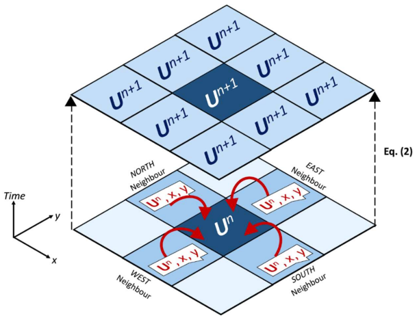
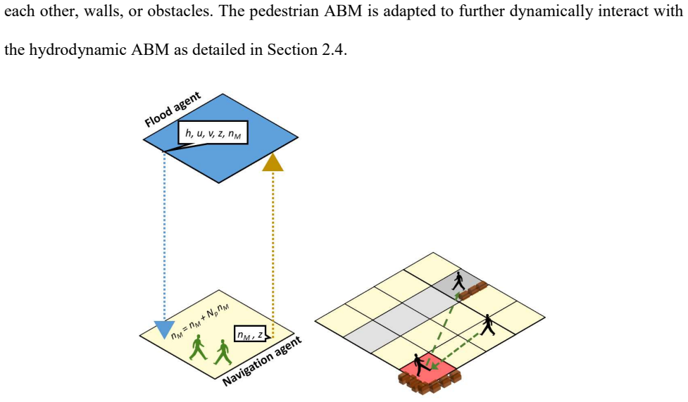
The mechanism that carries the argument is a grid of navigation agents sandwiched between the flood agents and the pedestrian agents. Each navigation agent receives a flood message, converts depth and velocity into a Hazard Rate, sends that rate to the pedestrians above it, and then receives messages from those pedestrians about how many are present or what sandbagging action they are performing. It updates local terrain parameters---$n_M = n_M + N_p n_M$ for evacuee crowding, or an increment of $z$ by one sandbag thickness for responders---and sends the updated terrain back to the flood agent. This intermediate grid makes the two-way feedback local, simultaneous, and independent of the numerical scheme, which is a first-order finite-volume solver of the shallow water equations with wetting and drying.
What would settle it
A direct test would be a flume experiment measuring water depth and velocity in a shallow current with and without a stationary or moving crowd, compared with the roughness augmentation $n_M = n_M + N_p n_M$; if measured depths and velocities do not follow that relation, the coupling's effect on evacuee risk states is not supported. A second check would measure actual human walking speeds across the HR ranges of the risk table.
Extended reading notes
Core claim
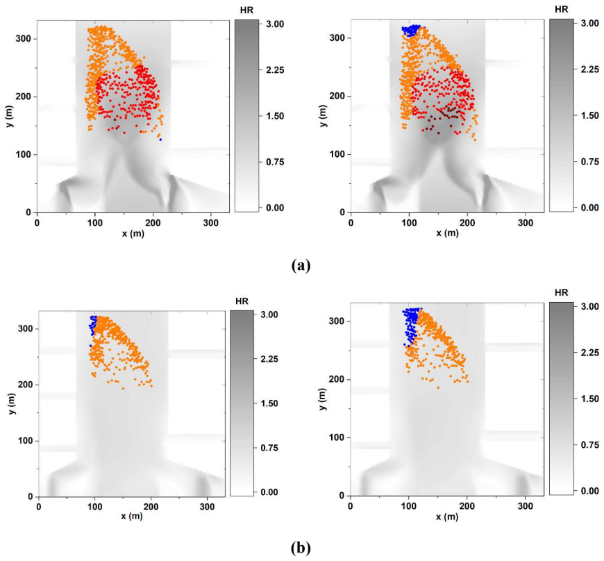
The central claim is that a single simulator can capture the two-way interaction between flood dynamics and pedestrian behaviour, and that this interaction materially changes predicted risk. On the flood-to-people side, each pedestrian receives a Hazard Rate $HR = (V + 0.5) \times h$ from the water and moves with a state-dependent speed: brisk walk below HR 0.75, slow walk below 1.5, slower below 2.5, and no walking above. On the people-to-flood side, groups of evacuees locally increase the Manning roughness $n_M$ by an amount proportional to the number of evacuees present, while responders progressively raise terrain height by dropping layers of sandbags. In the shopping-centre demonstration, ignoring the evacuee roughness feedback changes the spatial pattern of high- and medium-risk states: crowds in high-HR zones appear to raise the hazard around them, while crowds in medium-HR zones appear to reduce it. In the intervention scenario, a three-layer (0.75 m) sandbag barrier reached with at least 100 responders is predicted to be sufficient and safe within the 12-hour warning window.
Load-bearing premise
The whole two-way effect rests on uncalibrated rules: that each evacuee adds one unit of Manning roughness to the local terrain and that the flood-risk walking speeds follow the tabulated Hazard Rate thresholds; if the true hydrodynamic effect of a crowd is different, the paper's main finding that people dramatically affect flood impact would not hold.
Editorial extensions
If this is right
- Evacuation models that ignore two-way coupling may misstate where and when pedestrians become trapped, because crowd density itself can shift local hazard.
- The roughness feedback can either amplify or damp local risk depending on state: gathering in high-HR zones worsens surroundings, while gathering in medium-HR zones appears to buffer them.
- The simulator gives concrete planning numbers for sandbag barriers, including deployment time, barrier height, and residual risk reduction, such as a 91.2% drop in maximum HR after one layer and negligible gain beyond three layers.
- The method is general enough to be re-run on real urban sites once inflow conditions and exit locations are specified.
Reading between the lines
- If the crowd-roughness relation were calibrated empirically, the same coupling architecture could be applied to other crowded settings, such as stadiums or transport hubs, where gathering changes inundation paths.
- The directional effect of crowds may depend on flow regime: roughness that slows water could raise depth upstream of a crowd and lower speed downstream, which is a testable prediction of the model.
- A sensitivity analysis varying the exponent or prefactor of the roughness feedback would reveal how much of the reported risk-state change is due to the assumed rule rather than to the hydrodynamics.
- The responder results suggest that beyond a saturation point, extra manpower no longer shortens deployment time, a pattern worth testing against real sandbagging logistics.
Signed reviews
Editorial analysis
A structured set of objections, weighed in public.
Referee Report
Summary. The paper presents a coupled agent-based simulator that links a hydrodynamic ABM, based on an explicit finite-volume solver of the shallow water equations, with a pedestrian ABM built on social-force walking rules, all implemented on the FLAMEGPU GPU platform. Two-way coupling is achieved via intermediate navigation agents: evacuees alter local Manning roughness as a function of their local count, while responders construct sandbag barriers by incrementing terrain height. The simulator is demonstrated on a synthetic shopping-centre case with two scenarios: evacuation during a flood and pre-flood sandbag deployment. The authors report that evacuee feedback can 'dramatically affect' flood risk states, and that the responder simulations can guide decisions on manpower, barrier height, and risk reduction.
Significance. If the results hold, the paper offers a useful methodological advance: a GPU-accelerated, two-way coupled flood-pedestrian simulation framework, which goes beyond the one-way coupling used in most existing flood-evacuation ABMs. The authors are transparent about the assumptions underlying their behavioural rules, they provide software accessibility information, and the hydrodynamic solver is based on a published and well-established scheme. However, the central quantitative claim about evacuees 'dramatically' affecting flood risk states rests on an uncalibrated roughness feedback rule, and the claimed verification of the hydrodynamic component is not shown. These issues prevent the results from being taken as evidence of a validated interaction mechanism, though the framework itself is a plausible and potentially valuable building block.
major comments (4)
- [Section 2.4, Eq. (nM = nM + Np*nM)] The local terrain-roughness feedback rule nM = nM + Np*nM is the sole mechanism by which evacuee presence affects flood hydrodynamics in Scenario 1, and Figures 6-7 attribute the 'dramatic' differences in evacuee risk states to this rule. However, the rule is explicitly assumed (footnote 1) and no sensitivity analysis or calibration is provided. Because Manning friction enters the momentum equation through a term that scales with n^2, the cap of Np=20 raises the local resistance by a factor of up to 441 relative to the base value, so the reported 5-8% and 25% differences in hazard-rate areas test the prescribed forcing rather than an empirically supported crowd-resistance effect. The central claim of Section 3.2 therefore needs either a sensitivity sweep over the feedback parameter, a physically motivated alternative formulation, or a more guarded wording that distinguishes the demonstration from a validated finding.
- [Section 2.2] The verification of the hydrodynamic ABM is reported only in one sentence ('the hydrodynamic ABM (results not shown) reproduced the same predictions as the sequential counterpart'), without any comparison plot, error metric, or benchmark table. Since the credibility of the coupled simulator's flood physics depends on this solver, the authors should include the verification results, for example as an appendix with comparisons to the cited dam-break tests of Wang et al. (2011) and Huang et al. (2013).
- [Section 3.2 and Table 1] The walking speed states (1.8, 0.9, 0.45, and 0.0 m/s) assigned to the four HR ranges are assumed on the basis of the UK Environment Agency thresholds, as acknowledged in footnote 1, but the speed values themselves are not derived from empirical data and no sensitivity analysis is reported. The evacuation-time and risk-state statistics in Figures 6-7 may be sensitive to these choices, so the authors should either cite empirical studies of walking speed in floodwater or demonstrate that the qualitative conclusions are robust across a plausible range of speed values.
- [Section 3.3] The sandbag pickup and drop-off times are stated as 'half a minute' and described as 'specified' without a reference, yet the deployment-time estimates in Figure 8 and the resulting manpower recommendations depend directly on these values. The authors should cite a source for these action times, or perform a sensitivity analysis to show that the conclusion that a 10% responder group can deploy a three-layer barrier safely within 12 hours is robust to plausible variations in handling times.
minor comments (6)
- [Section 3.3 (text after Figure 9)] The phrase 'tree-layer thickness' appears to be a typo for 'three-layer thickness'.
- [Section 3.3 (caption of Figure 10)] The phrase 'in line with increased thickness' should be 'in line with increased thickness' or, more idiomatically, 'as the thickness increases'.
- [Section 2.1] The phrase 'like-for-like distribution' is vague; it should be clarified that the navigation and flood grids are collocated with identical cell sizes and alignments.
- [Section 3.1, Figure 5(b)] The sentence beginning 'With the hydrographs associated with...' is difficult to follow because it lists three conditions together; splitting it into separate statements would improve readability.
- [Abstract and Section 2.4] The abstract refers to a 'terrain roughness feedback factor' but this term is not defined in the methodology; the authors should either introduce this term explicitly in Section 2.4 or avoid it in the abstract.
- [Software accessibility] The software and data links (DAFNI and the project website) would benefit from a persistent identifier, such as a DOI or versioned release, to support reproducibility.
Circularity Check
No significant circularity: the two-way coupling is implemented from explicit assumptions rather than fitted to outputs.
full rationale
The paper does not reduce any of its conclusions to its inputs by construction. The crowd-roughness feedback nM = nM + Np*nM, the walking-speed reductions in Table 1, and the sandbag-deployment procedures are all prescribed modelling assumptions, not parameters calibrated to the simulated results. The HR thresholds are taken from the UK Environment Agency and are used consistently as both input labels and output metrics, which is a functional definition rather than a circular derivation. The central claim that evacuees can 'dramatically affect' flood impact on their own states is a simulation outcome produced by the explicitly stated feedback rule; the rule itself is not derived from that outcome, and the paper openly flags the assumptions as assumptions and lists validation as future work. Self-citations to FLAMEGPU and earlier pedestrian/hydrodynamic implementations support the software platform and numerical components, but the paper's flood-people interaction claim does not depend on any self-cited uniqueness theorem or imported ansatz. The hydrodynamic solver is cross-verified against independent dam-break test cases. The main weakness is that the roughness-feedback rule is uncalibrated and potentially strong, but that is a correctness and validation risk, not circularity.
Assumptions & free parameters
free parameters (4)
- Walking speed states in floodwater =
1.8, 0.9, 0.45, 0.0 m/s for low, medium, high, highest hazard
- Terrain roughness feedback factor =
nM = nM + Np*nM, max Np = 20 so nM max about 0.21
- Sandbag pickup and drop-off time =
0.5 minutes each
- Initial Manning's n =
0.01
assumptions (4)
- domain assumption Shallow water equations with Manning friction govern flood dynamics
- domain assumption Social force model describes pedestrian movement and evacuation
- domain assumption Hazard Rate HR = (V + 0.5) * h maps to risk states
- standard math The finite volume scheme is first-order accurate and stable under CFL
Cite this review
Pith. "Pith review of Agent-based simulator of dynamic flood-people interactions." pith.science (2026). https://pith.science/paper/QCUFMLJF
@misc{pith2026190805232,
  author       = {Pith},
  title        = {Pith review of: Agent-based simulator of dynamic flood-people interactions},
  year         = {2026},
  howpublished = {\url{https://pith.science/paper/QCUFMLJF}},
  note         = {Machine review of arXiv:1908.05232}
}
read the original abstract
This paper presents a new simulator for dynamic modelling of interactions between flooding and people in crowded areas. The simulator is developed in FLAMEGPU (a Flexible Large scale Agent-based Modelling Environment for the GPU), which allows to model multiple agent interactions while benefitting from the speed-up of GPUs. Flooding variables including terrain data are represented by a hydrodynamic Agent-Based Model (ABM) that is based on a non-sequential implementation of a robust Finite Volume (FV) solver of the Shallow Water Equations (SWEs). People movements are represented by a pedestrian ABM adopting force-based walking rules. The hydrodynamic ABM is coupled to the pedestrian ABM according to risk-to-life thresholds reported by the UK Environment Agency (EA). A hypothetical case study of a crowded shopping centre is proposed and used to assess the dynamic coupling ability of the simulator. Flooding into the shopping centre is induced based on realistic inflow conditions, and the simulator is applied considering two scenarios: evacuation without advanced warning and intervention with an advanced warning of 12 hours. Results show that the simulator can produce detailed statistics of spatiotemporal people states during evacuation, and is useful to plan safe and effective people intervention to deploy a sandbag-based temporary barriers.
Figures

Figures from the paper (7 more)




Reference graph
Works this paper leans on
-
[1]
Abebe, Y.A., Ghorbani, A., Nikolic, I., Vojinovic, Z., & Sanchez, A. (2019). A coupled flood- agent-institution modelling (CLAIM) framework for urban flood risk anagement. Environmental modelling & software, 111, 483-492. Aerts, J.C., Botzen, W.J., Clarke, K.C., Cutter, S.L., Hall, J.W., Merz, B., Michel-Kerjan, E., Mysiak, J., Surminski, S., & Kunreuther...
work page 2019
-
[31]
Richmond, P., Coakley, S., & Romano, D. M. (2009). A high performance agent based modelling framework on graphics card hardware with CUDA. In Proceedings of the 8th International Conference on Autonomous Agents and Multiagent Systems, pp. 1125-1126. 10-15 May 2009, Budapest, Hungary. 26 Sen Nag, O. (2018). The Largest Shopping Malls in the United Kingdom ...
work page 2009
-
[77]
Lumbroso, D. M., Simm, J. D., Davison, M., White, K. D., & Durden, S. (2015). Use of agent- based modelling to validate hurricane evacuation planning. In Coastal structures and solutions to coastal disasters joint conference (COPRI), pp. 321-329. 9–11 September 2015, Boston, USA. Lumbroso, D., & Davison, M. (2018). Use of an agent‐based model and Monte Ca...
work page 2015
-
[193]
Becker, J. S., Taylor, H. L., Doody, B. J., Wright, K. C., Gruntfest, E., & Webber, D. (2015). A review of people’s behavior in and around floodwater. Weather, Climate, and Society, 7(4), 321-
work page 2015
-
[275]
Liu, X., & Lim, S. (2016). Integration of spatial analysis and an agent-based model into evacuation management for shelter assignment and routing. Journal of spatial science, 61(2), 283-298. Liu, Y., Okada, N., Shen, D., & Li, S. (2009). Agent-based flood evacuation simulation of life- threatening conditions using vitae system model. Journal of Natural Di...
work page 2016
-
[332]
22 Bernardini, G., Postacchini, M., Quagliarini, E., Brocchini, M., Cianca, C., & D'Orazio, M. (2017). A preliminary combined simulation tool for the risk assessment of pedestrians’ flood-induced evacuation. Environmental modelling & software, 96, 14-29. Bernardini, G., Quagliarini, E., D'Orazio, M., & Brocchini, M. (2020). Towards the simulation of flood...
work page 2017
-
[4282]
Helbing, D., Farkas, I., & Vicsek, T. (2000). Simulating dynamical features of escape panic. Nature, 407(6803), 487-490. Hellevang, K. (2011). Sandbagging for flood protection AE-626 (Revised). National Institute of Food and Agriculture, U.S. Department of Agriculture, Agreement No. 2009-41210-05965. Huang, Y., Zhang, N., & Pei, Y. (2013). Well-balanced f...
work page 2000
Reviewed August 14, 2026 · model on record in the stance chip above.
Discussion (0). Continue with ORCID to comment.