Multi-Depth Uniform Coverage Path Planning for Unmanned Surface Vehicle Surveying
Pith reviewed 2026-05-14 18:26 UTC · model grok-4.3
The pith
An algorithm for USV bathymetry surveys adapts path spacing and sensor range to depth variations for uniform seafloor coverage over 99 percent.
A machine-rendered reading of the paper's core claim, the machinery that carries it, and where it could break.
Core claim
The central discovery is a path planning scheme that incorporates coarse prior depth information to pre-process the target region and adaptively guide path generation and sensing range configuration. By explicitly accounting for depth variations, it designs a coverage path with optimised spacing between survey passes that adjusts the sensing beam aperture to achieve more consistent seafloor coverage, demonstrated by coverage ratios beyond 99% in synthetic terrains and over 92% in realistic simulations using real bathymetric data.
What carries the argument
Adaptive coverage path generation using prior depth data to optimize survey pass spacing and adjust multibeam echo sounder beam aperture for uniform seafloor coverage.
If this is right
- Offers a fully automated design process suitable for autonomous marine vehicles.
- Delivers marked improvements in coverage for both synthetic challenging terrains and real coastal harbour data.
- Reduces reliance on manual selection of waypoints at constant depths.
- Provides practical utilities for real-world bathymetric survey applications.
Where Pith is reading between the lines
- Integrating this depth-adaptive planning with online sensor feedback could further refine coverage in unknown areas.
- Similar principles might extend to other depth-sensitive sensors in marine robotics beyond multibeam systems.
- The reduced coverage gaps could decrease the number of required survey passes, lowering time and fuel costs in operations.
Load-bearing premise
The approach relies on coarse prior depth information being available and accurate enough to pre-process the region and predict coverage without introducing large errors.
What would settle it
Performing a survey in a region with inaccurate or missing prior depth data and measuring whether the actual achieved coverage drops significantly below the predicted high ratios.
Figures


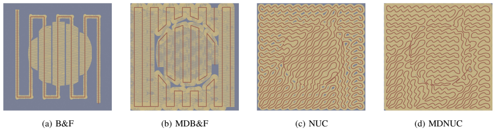


read the original abstract
This paper introduces a novel automatic coverage path planning algorithm for bathymetry surveying with unmanned surface vehicles. The detection range of the mapping sensor employed - a multibeam echo sounder - is heavily influenced by local seafloor depths. Hence, a path designed to uniformly cover the sea surface does not guarantee uniform coverage of the seafloor. Yet this is currently the typical process for bathymetric surveys, with the simplistic boustrophedon scheme along manually selected waypoints at constant depths being the most widespread planner used. The proposed scheme incorporates coarse prior depth information to pre-process the target region and adaptively guide path generation and sensing range configuration. By explicitly accounting for depth variations, the proposed algorithm designs a coverage path with optimised spacing between survey passes that adjusts the sensing beam aperture to achieve more consistent seafloor coverage. The proposed method is shown to offer significant improvements in both synthetic and real-world scenarios. Validations in challenging synthetic terrains achieves coverage ratios beyond 99%, a marked improvement when compared with traditional boustrophedon paths revealing a maximum 75% coverage. The same trend appears in realistic simulations using real bathymetric data from a coastal harbour, with coverage reaching over 92%, and significantly surpassing boustrophedon sweeps with coverage rates below 65%. Beyond improved performance, the scheme also brings a fully automated design, suitable for autonomous marine vehicles, thus offering practical utilities for real-world applications.
Editorial analysis
A structured set of objections, weighed in public.
Referee Report
Summary. The paper introduces an automatic coverage path planning algorithm for bathymetry surveying with unmanned surface vehicles using multibeam echo sounders. It incorporates coarse prior depth information to pre-process the target region, adaptively optimize spacing between survey passes, and adjust sensing beam aperture for uniform seafloor coverage rather than uniform surface coverage. Validations on challenging synthetic terrains report coverage ratios beyond 99% (vs. at most 75% for boustrophedon), with similar gains on real bathymetric data from a coastal harbour (>92% vs. <65%). The approach is fully automated and suitable for autonomous marine vehicles.
Significance. If the central assumptions hold, the work offers a practical advance for autonomous bathymetric surveying by explicitly accounting for depth-dependent sensor range, yielding more consistent seafloor coverage and reducing reliance on manual constant-depth waypoints. The concrete numerical comparisons on both synthetic and real data, together with the automated design, provide a clear baseline for further research in marine robotics. Strengths include the explicit handling of variable depth effects and the reported performance deltas against a standard baseline.
major comments (1)
- [Abstract and validation results] Abstract and validation results: The reported coverage ratios (>99% synthetic, >92% real bathymetry) are obtained under the assumption that the coarse prior depth map is sufficiently accurate to correctly set variable pass spacing and beam aperture. No sensitivity analysis, noise injection, or comparison to ground-truth depths is described; a mismatch would invalidate the optimized parameters and collapse the uniformity guarantee. This is load-bearing for the central claim and requires explicit robustness testing before the performance numbers can be taken as general.
Simulated Author's Rebuttal
We thank the referee for the positive assessment of our work and for the constructive major comment. We agree that robustness to inaccuracies in the prior depth map is important for the central claims and will add explicit sensitivity analysis in the revision.
read point-by-point responses
-
Referee: [Abstract and validation results] Abstract and validation results: The reported coverage ratios (>99% synthetic, >92% real bathymetry) are obtained under the assumption that the coarse prior depth map is sufficiently accurate to correctly set variable pass spacing and beam aperture. No sensitivity analysis, noise injection, or comparison to ground-truth depths is described; a mismatch would invalidate the optimized parameters and collapse the uniformity guarantee. This is load-bearing for the central claim and requires explicit robustness testing before the performance numbers can be taken as general.
Authors: We acknowledge that the reported performance relies on the prior depth map being sufficiently accurate for setting pass spacing and beam aperture. In the current manuscript the priors are described as coarse (derived from existing bathymetric charts or low-resolution surveys) and the algorithm is designed to tolerate moderate deviations by adaptively adjusting beam aperture. To directly address the concern we will add a dedicated sensitivity study in the revised manuscript: Gaussian noise with standard deviations of 5 m, 10 m and 20 m will be injected into the prior depth maps for both the synthetic terrains and the real harbour dataset; coverage ratios will be recomputed and tabulated. This will quantify how performance degrades with increasing prior error and will support the claim that the method remains superior to boustrophedon even under realistic prior inaccuracies. revision: yes
Circularity Check
No significant circularity; algorithm and coverage metrics are independently derived from external simulation benchmarks
full rationale
The paper's core contribution is an algorithmic procedure that ingests coarse prior depth maps to compute adaptive pass spacing and beam apertures, then evaluates the resulting coverage via forward simulation on both synthetic terrains and real bathymetric datasets. Coverage ratios (>99% synthetic, >92% real) are computed outputs of this simulation process, not parameters fitted to the same data or defined in terms of themselves. No equations reduce the claimed uniformity guarantee to a tautology, and the boustrophedon baseline is an external comparator. No self-citations are invoked as load-bearing uniqueness theorems or ansatzes. The derivation chain therefore remains self-contained against the stated simulation benchmarks.
Axiom & Free-Parameter Ledger
axioms (2)
- domain assumption Coarse prior depth information is available and accurate enough to guide adaptive planning
- domain assumption Multibeam echo sounder detection range varies predictably with local seafloor depth
Reference graph
Works this paper leans on
-
[1]
B. Kum, D. Shin, S. Jang, S. Y . Lee, J. H. Lee, T. Moh, D. G. Lim, J. Do, and J. H. Cho, “Application of unmanned surface ve- hicles in coastal environments: Bathymetric survey using a multibeam echosounder,”J. Coast. R., vol. 95, no. SI, pp. 1152–1156, 2020
work page 2020
-
[2]
L. Castano-Londono, S. P. Marrugo Llorente, E. Paipa-Sanabria, D. I. Orozco-Lopez, M. B. F. M., and D. Gonzalez Montoya, “Evolution of algorithms and applications for unmanned surface vehicles in the context of small craft: A systematic review.”Appl. Sci., vol. 14, no. 21, 2024
work page 2024
-
[3]
A survey on coverage path planning for robotics,
E. Galceran and M. Carreras, “A survey on coverage path planning for robotics,”Robot. Auton. Sys., vol. 61, no. 12, pp. 1258–1276, 2013
work page 2013
-
[4]
Coverage of known spaces: The boustrophedon cellular decomposition,
h. Choset, “Coverage of known spaces: The boustrophedon cellular decomposition,”Auton. Robot., vol. 9, no. 3, pp. 247–253, 2000
work page 2000
-
[5]
Energy-aware spiral coverage path planning for uav photogrammetric applications,
T. M. Cabreira, C. Di Franco, P. R. Ferreira, and G. C. Buttazzo, “Energy-aware spiral coverage path planning for uav photogrammetric applications,”Robot. Autom. Let., vol. 3, no. 4, pp. 3662–3668, 2018
work page 2018
-
[6]
Bathymetric Survey Path on the Ausable River,
Ausable Freshwater Center, “Bathymetric Survey Path on the Ausable River,” www.ausableriver.org/blog/how-are-bathymetric-maps-made, September 2025
work page 2025
-
[7]
Morse decompositions for coverage tasks,
E. Acar, H. Choset, P. Rizzi, A.and Atkar, and D. Hull, “Morse decompositions for coverage tasks,”Intl. J. of Robotics Res., vol. 21, no. 4, pp. 331–344, 2002
work page 2002
-
[8]
L. Zhao and Y . Bai, “Joint-optimized coverage path planning frame- work for usv-assisted offshore bathymetric mapping: From theory to practice,”Knowl.-Based Syst., vol. 304, p. 112449, 2024
work page 2024
-
[9]
Template- free nonrevisiting uniform coverage path planning on curved surfaces,
T. Yang, J. Valls Miro, M. Nguyen, Y . Wang, and R. Xiong, “Template- free nonrevisiting uniform coverage path planning on curved surfaces,” T. Mechatr., vol. 28, no. 4, pp. 1853–1861, 2023
work page 2023
-
[10]
Autonomous mo- bile robot path planning techniques, a review: Classical and heuristic techniques
M. Badamasi, I. Kabir, G. Ahmed, and S. El-Ferik, “Autonomous mo- bile robot path planning techniques, a review: Classical and heuristic techniques.”Access, 2025
work page 2025
-
[11]
L. Yi, A. Y . S. Wan, A. V . Le, A. A. Hayat, Q. R. Tang, and R. E. Mohan, “Complete coverage path planning for reconfigurable omni- directional mobile robots with varying width using gbnn (n),”Expert Syst. Appl., vol. 228, p. 120349, 2023
work page 2023
-
[12]
Survey on coverage path planning with unmanned aerial vehicles,
T. Cabreira, L. Brisolara, and F. Paulo R, “Survey on coverage path planning with unmanned aerial vehicles,”Drones, vol. 3, no. 1, p. 4, 2019
work page 2019
-
[13]
K. R. Jensen-Nau, T. Hermans, and K. K. Leang, “Near-optimal area-coverage path planning of energy-constrained aerial robots with application in autonomous environmental monitoring,”T. Autom. Sci. Eng., vol. 18, no. 3, pp. 1453–1468, 2020
work page 2020
-
[14]
A novel ant colony- inspired coverage path planning for internet of drones,
L. Bine, A. Boukerche, L. Ruiz, and A. Loureiro, “A novel ant colony- inspired coverage path planning for internet of drones,”Comput. Netw., vol. 235, p. 109963, 2023
work page 2023
-
[15]
Area-coverage planning for spray-based surface disinfection with a mobile manipulator,
S. Thakar, R. Malhan, P. Bhatt, and S. Gupta, “Area-coverage planning for spray-based surface disinfection with a mobile manipulator,” Robot. Auton. Syst., vol. 147, p. 103920, 2022
work page 2022
-
[16]
A review of path planning for unmanned surface vehicles,
B. Xing, M. Yu, Z. Liu, Y . Tan, Y . Sun, and B. Li, “A review of path planning for unmanned surface vehicles,”J. Mar. Sci. Eng., vol. 11, no. 8, p. 1556, 2023
work page 2023
-
[17]
Path planning for multi-usv target coverage in complex environments,
J. Luo and Y . Su, “Path planning for multi-usv target coverage in complex environments,”Ocean Eng., vol. 312, p. 119090, 2024
work page 2024
-
[18]
L. Zhao, Y . Bai, and J. K. Paik, “Optimal coverage path planning for usv-assisted coastal bathymetric survey: Models, solutions, and lake trials,”Ocean Eng., vol. 296, p. 116921, 2024
work page 2024
-
[19]
A coverage path planning approach for environmental monitoring using an unmanned surface vehicle,
S. K. R. Sudha, D. Mishra, and I. Hameed, “A coverage path planning approach for environmental monitoring using an unmanned surface vehicle,”Ocean Eng., vol. 310, p. 118645, 2024
work page 2024
-
[20]
Optimal coverage path planning for uav-assisted multiple usvs: Map modeling and solutions,
S. Pan, X. Xu, Y . Cao, and L. Zhang, “Optimal coverage path planning for uav-assisted multiple usvs: Map modeling and solutions,”Drones, vol. 9, no. 1, p. 30, 2025
work page 2025
-
[21]
L. Zhao and Y . Bai, “Energy efficient coverage path planning for usv- assisted inland bathymetry under current effects: An analysis on sweep direction,”Ocean Eng., vol. 305, p. 117910, 2024
work page 2024
-
[22]
A. K. Lakshmanan, R. E. Mohan, B. Ramalingam, A. V . Le, P. Veer- ajagadeshwar, K. Tiwari, and M. Ilyas, “Complete coverage path planning using reinforcement learning for tetromino based cleaning and maintenance robot,”Automat. Constr., vol. 112, p. 103078, 2020
work page 2020
-
[23]
Energy-efficient coverage path planning for general terrain surfaces,
C. Wu, C. Dai, X. Gong, Y .-J. Liu, J. Wang, X. D. Gu, and C. C. L. Wang, “Energy-efficient coverage path planning for general terrain surfaces,”Robot. Autom. Let., vol. 4, no. 3, pp. 2584–2591, 2019
work page 2019
-
[24]
Planning paths of complete coverage of an unstructured environment by a mobile robot,
A. Zelinsky, R. A. Jarvis, J. Byrne, S. Yuta,et al., “Planning paths of complete coverage of an unstructured environment by a mobile robot,” inProcs. of Intl. Conf. on Adv. Robotics., vol. 13, 1993, pp. 533–538
work page 1993
-
[25]
Spanning-tree based coverage of continu- ous areas by a mobile robot,
Y . Gabriely and E. Rimon, “Spanning-tree based coverage of continu- ous areas by a mobile robot,”Annals of Math. and Artif. Intel., vol. 31, no. 1, pp. 77–98, 2001
work page 2001
-
[26]
Fractal trajectories for online non-uniform aerial coverage,
S. A. Sadat, J. Wawerla, and R. Vaughan, “Fractal trajectories for online non-uniform aerial coverage,” inintl. Conf. on Robotics and Autom. (ICRA), 2015, pp. 2971–2976
work page 2015
-
[27]
Cellular decomposition for non-repetitive coverage task with minimum dis- continuities,
T. Yang, J. Valls Miro, Q. Lai, Y . Wang, and R. Xiong, “Cellular decomposition for non-repetitive coverage task with minimum dis- continuities,”T. Mechatr., vol. 25, no. 4, pp. 1698–1708, 2020
work page 2020
-
[28]
A deformable spiral based algorithm to smooth coverage path planning for marine growth removal,
M. Hassan and D. Liu, “A deformable spiral based algorithm to smooth coverage path planning for marine growth removal,” inIntl. Conf. on Intel. Robs. and Sys. (IROS), 2018, pp. 1913–1918
work page 2018
-
[29]
Coverage path planning with targetted viewpoint sampling for robotic free-form surface in- spection,
E. Glorieux, P. Franciosa, and D. Ceglarek, “Coverage path planning with targetted viewpoint sampling for robotic free-form surface in- spection,”Robot. Com.-Int. Manuf., vol. 61, p. 101843, 2020
work page 2020
-
[30]
Ppcpp: A predator–prey-based approach to adaptive coverage path planning,
M. Hassan and D. Liu, “Ppcpp: A predator–prey-based approach to adaptive coverage path planning,”T. on Robotics, vol. 36, no. 1, pp. 284–301, 2019
work page 2019
-
[31]
Route planning algorithms for unmanned surface vehicles (usvs): a comprehensive analysis,
S. D. Hashali, S. Yang, and X. Xiang, “Route planning algorithms for unmanned surface vehicles (usvs): a comprehensive analysis,”J. Mar. Sci. Eng., vol. 12, no. 3, p. 382, 2024
work page 2024
-
[32]
Efficient seabed coverage path planning for asvs and auvs,
E. Galceran and M. Carreras, “Efficient seabed coverage path planning for asvs and auvs,” inIntl. Conf. on Intel. Robs. and Sys. (IROS), 2012, pp. 88–93
work page 2012
-
[33]
M. Sun, L. Yu, P. Zhang, Q. Sun, X. Jiao, D. Sun, and F. Lun, “Coastal water bathymetry for critical zone management using regression tree models from gaofen-6 imagery,”Ocean & Coast. Manag., vol. 204, p. 105522, 2021
work page 2021
-
[34]
Automatic collaborative water surface coverage and cleaning strategy of uav and usvs,
T. Deng, X. Xu, Z. Ding, X. Xiao, M. Zhu, and K. Peng, “Automatic collaborative water surface coverage and cleaning strategy of uav and usvs,”Digit. Commun. Netw., vol. 11, no. 2, pp. 365–376, 2025
work page 2025
-
[35]
A collaborative search method for usv swarms using the b-cnp algorithm for water area coverage,
X. Jiang and X. Fang, “A collaborative search method for usv swarms using the b-cnp algorithm for water area coverage,”J. Mar. Sci. Eng., vol. 13, no. 4, p. 672, 2025
work page 2025
-
[36]
Y . Ma, Y . Zhao, Z. Li, H. Bi, J. Wang, R. Malekian, and M. A. Sotelo, “Cciba*: An improved ba* based collaborative coverage path planning method for multiple unmanned surface mapping vehicles,”T. Intell. Transp., vol. 23, no. 10, pp. 19 578–19 588, 2022
work page 2022
-
[37]
F. Tang, “Coverage path planning of unmanned surface vehicle based on improved biological inspired neural network,”Ocean Eng., vol. 278, p. 114354, 2023
work page 2023
-
[38]
Cooperative survey of seabed rois using multiple usvs with coverage path planning,
S. Yang, J. Huang, X. Xiang, J. Li, and Y . Liu, “Cooperative survey of seabed rois using multiple usvs with coverage path planning,”Ocean Eng., vol. 268, p. 113308, 2023
work page 2023
-
[39]
Toward maritime robotic simu- lation in gazebo,
B. Bingham, C. Ag ¨uero, M. McCarrin, J. Klamo, J. Malia, K. Allen, T. Lum, M. Rawson, and R. Waqar, “Toward maritime robotic simu- lation in gazebo,” inOCEANS, 2019, pp. 1–10
work page 2019
discussion (0)
Sign in with ORCID, Apple, or X to comment. Anyone can read and Pith papers without signing in.