A CNN-Based Super-Resolution Technique for Active Fire Detection on Sentinel-2 Data
Pith reviewed 2026-05-25 16:55 UTC · model grok-4.3
The pith
CNN-based super-resolution enhances Sentinel-2 SWIR bands to 10 meters for active fire detection.
A machine-rendered reading of the paper's core claim, the machinery that carries it, and where it could break.
Core claim
The proposed CNN-based super-resolution data fusion method achieves better results than alternative methods in terms of some accuracy metrics when moving the SWIR bands of Sentinel-2 toward 10-m spatial resolution. When these super-resolved bands are used to monitor active fire through classic indices, the method provides advantages and limits that are validated on the mount Vesuvius area damaged by fires in summer 2017.
What carries the argument
A convolutional neural network for super-resolution data fusion that upsamples the 20-meter SWIR bands to 10-meter resolution while aiming to preserve spectral properties.
If this is right
- The super-resolved bands enable more detailed active fire detection maps.
- The CNN method outperforms alternatives on accuracy metrics.
- The approach is validated through application to real fire events using standard indices.
- Advantages and limits are identified for the specific geographical test area.
Where Pith is reading between the lines
- This technique could potentially improve fire detection in other regions with similar Sentinel-2 data.
- Integration with other resolution enhancement methods might further refine results.
- Real-world deployment could lead to earlier or more precise fire response if spectral fidelity holds.
Load-bearing premise
The CNN super-resolution must preserve the spectral fidelity of the SWIR bands so that active fire indices remain reliable without artifacts that distort detection on actual fire events.
What would settle it
Ground-truth fire locations from independent high-resolution imagery or field reports where the fire indices from CNN-super-resolved bands show no improvement or degradation compared to native 20m bands.
Figures
read the original abstract
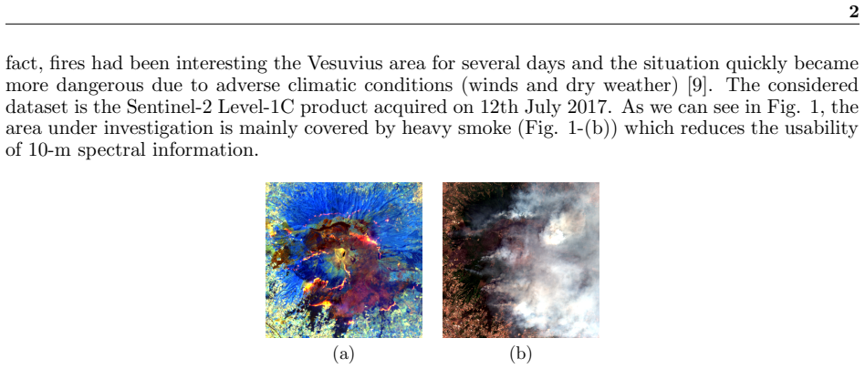
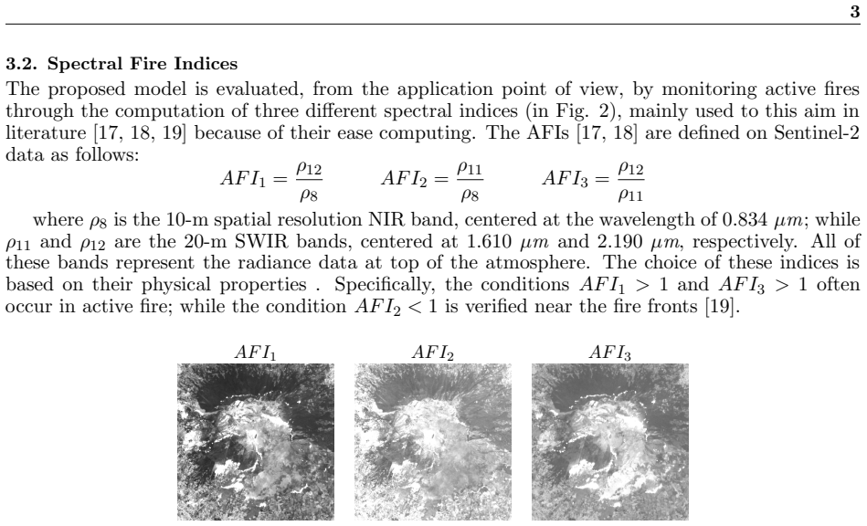
Remote Sensing applications can benefit from a relatively fine spatial resolution multispectral (MS) images and a high revisit frequency ensured by the twin satellites Sentinel-2. Unfortunately, only four out of thirteen bands are provided at the highest resolution of 10 meters, and the others at 20 or 60 meters. For instance the Short-Wave Infrared (SWIR) bands, provided at 20 meters, are very useful to detect active fires. Aiming to a more detailed Active Fire Detection (AFD) maps, we propose a super-resolution data fusion method based on Convolutional Neural Network (CNN) to move towards the 10-m spatial resolution the SWIR bands. The proposed CNN-based solution achieves better results than alternative methods in terms of some accuracy metrics. Moreover we test the super-resolved bands from an application point of view by monitoring active fire through classic indices. Advantages and limits of our proposed approach are validated on specific geographical area (the mount Vesuvius, close to Naples) that was damaged by widespread fires during the summer of 2017.
Editorial analysis
A structured set of objections, weighed in public.
Referee Report
Summary. The manuscript proposes a CNN-based super-resolution data fusion method to enhance the spatial resolution of Sentinel-2 SWIR bands from 20m to 10m for more detailed active fire detection. It claims better results than alternative methods in some accuracy metrics and validates the approach by testing super-resolved bands with classic active fire indices on the 2017 Vesuvius fire events.
Significance. If the quantitative results support the claims, this could be a useful contribution to remote sensing by improving the utility of Sentinel-2 data for fire monitoring applications. The application point of view validation on real events is a strength that goes beyond pure metric comparison.
major comments (2)
- Abstract: the claim of superior accuracy metrics and successful index-based monitoring supplies no quantitative values, error bars, dataset sizes, or validation details, making the central claim impossible to assess from the provided text.
- Validation section on Vesuvius events: the central application claim requires explicit evidence that super-resolution preserves SWIR spectral fidelity (e.g., before/after comparison of fire index values or detection maps on the 2017 events) to rule out artifacts that could distort results.
minor comments (1)
- Methods: expand the CNN architecture description with details on the number of input bands, loss function, and training dataset size to support reproducibility.
Simulated Author's Rebuttal
We thank the referee for the detailed review and constructive suggestions. We address the two major comments below and will incorporate revisions to improve clarity and evidence in the manuscript.
read point-by-point responses
-
Referee: Abstract: the claim of superior accuracy metrics and successful index-based monitoring supplies no quantitative values, error bars, dataset sizes, or validation details, making the central claim impossible to assess from the provided text.
Authors: We agree that the abstract is too terse and does not allow readers to evaluate the central claims. In the revised manuscript we will expand the abstract to include the key quantitative accuracy metrics (PSNR/SSIM values and the specific indices where improvement is observed), the size of the training and test sets, and a brief statement of the Vesuvius validation protocol. revision: yes
-
Referee: Validation section on Vesuvius events: the central application claim requires explicit evidence that super-resolution preserves SWIR spectral fidelity (e.g., before/after comparison of fire index values or detection maps on the 2017 events) to rule out artifacts that could distort results.
Authors: The current validation demonstrates that the super-resolved SWIR bands can be used with standard active-fire indices on the 2017 Vesuvius events, but we acknowledge that direct before/after comparisons of index values and detection maps are not presented. We will add these explicit comparisons (original 20 m vs. super-resolved 10 m index maps and quantitative differences) to the revised validation section to demonstrate spectral fidelity. revision: yes
Circularity Check
No significant circularity identified
full rationale
The paper presents a standard supervised CNN pipeline for super-resolving Sentinel-2 SWIR bands to 10 m, followed by empirical comparison against alternative methods on accuracy metrics and downstream validation via active-fire indices on the 2017 Vesuvius events. No load-bearing step reduces by construction to its own inputs, fitted parameters renamed as predictions, or self-citation chains; the central claims rest on data-driven training and external benchmarks rather than definitional equivalence or imported uniqueness theorems.
Axiom & Free-Parameter Ledger
Reference graph
Works this paper leans on
-
[1]
Neha Joshi, Matthias Baumann, Andrea Ehammer, Rasmus Fensholt, Kenneth Grogan, Patrick Hostert, Martin Jepsen, Tobias Kuemmerle, Patrick Meyfroidt, Edward Mitchard, et al., “A review of the application of optical and radar remote sensing data fusion to land use mapping and monitoring,” Remote Sensing, vol. 8, no. 1, pp. 70, 2016
work page 2016
-
[2]
Sentinel-2: Esa’s optical high-resolution mission for gmes operational services,
M. Drusch et al., “Sentinel-2: Esa’s optical high-resolution mission for gmes operational services,” Remote Sensing of Environment, vol. 120, no. Supplement C, pp. 25 – 36, 2012, The Sentinel Missions - New Opportunities for Science
work page 2012
-
[3]
Astrid Verhegghen, Hugh Eva, Guido Ceccherini, Frederic Achard, Valery Gond, Sylvie Gourlet-Fleury, and Paolo Cerutti, “The potential of Sentinel satellites for burnt area mapping and monitoring in the Congo Basin forests,” Remote Sensing, vol. 8, no. 12, pp. 986, 2016
work page 2016
-
[4]
Landsat-8 and Sentinel-2 for fire monitoring at a local scale: A case study on Vesuvius,
L Cicala, CV Angelino, N Fiscante, and SL Ullo, “Landsat-8 and Sentinel-2 for fire monitoring at a local scale: A case study on Vesuvius,” in 2018 IEEE International Conference on Environmental Engineering (EE). IEEE, 2018, pp. 1–6
work page 2018
-
[5]
Jos´ e Pereira, Emilio Chuvieco, A Beudoin, and N Desbois, “Remote sensing of burned areas: A review. A review of remote sensing methods for the study of large wildland fires,”Departamento de Geografa, Universidad de Alcal , pp. 127–184, 01 1997
work page 1997
-
[6]
Studies on land surface temperature over heteroge- neous areas using AVHRR data,
Yogesh Kant and K. V. S. Badarinath, “Studies on land surface temperature over heteroge- neous areas using AVHRR data,” International Journal of Remote Sensing , vol. 21, no. 8, pp. 1749–1756, 2000
work page 2000
-
[7]
Lucien Wald, Data Fusion. Definitions and Architectures - Fusion of Images of Different Spatial Resolutions, Presses de l’Ecole, Ecole des Mines de Paris, Paris, France, 2002, ISBN 2-911762-38-X
work page 2002
-
[8]
Vesuvius national park monitoring by COSMO-SkyMed PingPong data analysis,
Lucio Mascolo, Maurizio Sarti, Ferdinando Nunziata, and Maurizio Migliaccio, “Vesuvius national park monitoring by COSMO-SkyMed PingPong data analysis,” in ESA Special Pub- lication, 2013, vol. 713
work page 2013
-
[9]
Gli incendi boschivi stanno cambiando: cambiamo le strategie per governarli,
G Bovio, M Marchetti, L Tonarelli, M Salis, G Vacchiano, R Lovreglio, M Elia, P Fiorucci, and D Ascoli, “Gli incendi boschivi stanno cambiando: cambiamo le strategie per governarli,” Foresta - Rivista di Selvicoltura ed Ecologia Forestale , , no. 4, pp. 202–205, 2017
work page 2017
-
[10]
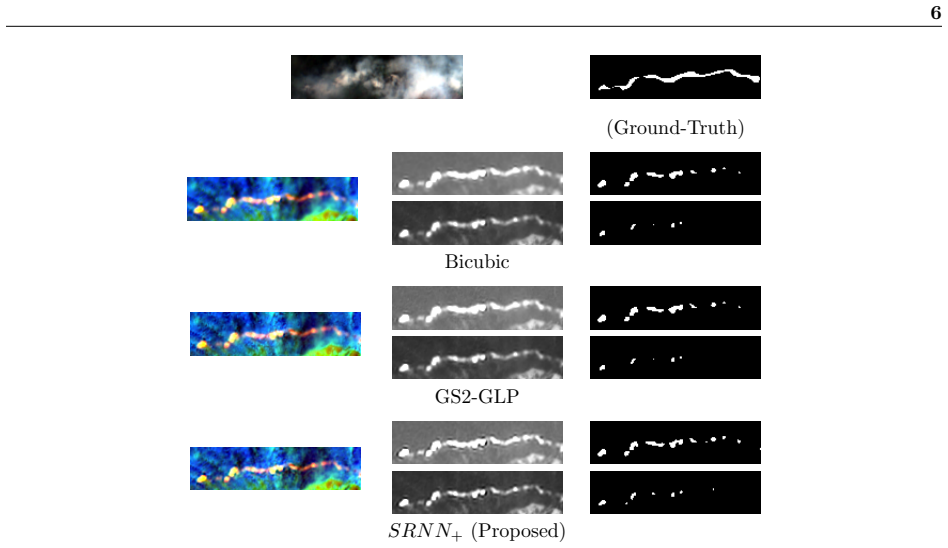
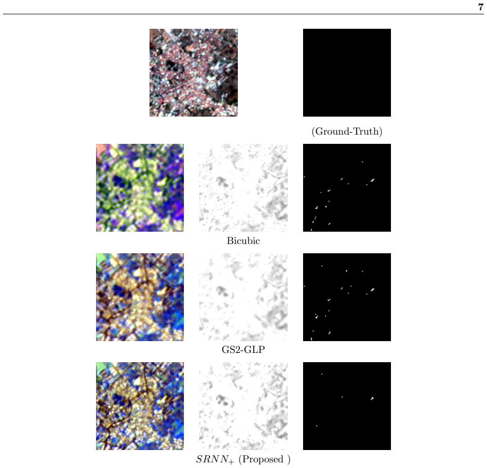
Wei Guo, Wen Yang, Haijian Zhang, and Guang Hua, “Geospatial Object Detection in High Resolution Satellite Images Based on Multi-Scale Convolutional Neural Network,” Remote Sensing, vol. 10, no. 1, pp. 131, 2018. 7 (Ground-Truth) Bicubic GS2-GLP SRNN + (Proposed ) Figure 6: In the first row the RGB image in which we can observe the absense of the smoke and...
work page 2018
-
[11]
Imagenet classification with deep convolutional neural networks,
Alex Krizhevsky, Ilya Sutskever, and Geoffrey E. Hinton, “Imagenet classification with deep convolutional neural networks,” pp. 1106–1114, 2012
work page 2012
-
[12]
Target-adaptive cnn-based pansharpening,
G. Scarpa, S. Vitale, and D. Cozzolino, “Target-adaptive cnn-based pansharpening,” IEEE Transactions on Geoscience and Remote Sensing , vol. 56, no. 9, pp. 5443–5457, Sept 2018
work page 2018
-
[13]
A CNN-Based Fusion Method for Super-Resolution of Sentinel-2 data,
Massimiliano Gargiulo, Antonio Mazza, Raffaele Gaetano, Giuseppe Ruello, and Giuseppe Scarpa, “A CNN-Based Fusion Method for Super-Resolution of Sentinel-2 data,” IGARSS, 2018
work page 2018
-
[14]
Pansharpening by convolutional neural networks,
Giuseppe Masi, Davide Cozzolino, Luisa Verdoliva, and Giuseppe Scarpa, “Pansharpening by convolutional neural networks,” Remote Sensing, vol. 8, no. 7, pp. 594, 2016
work page 2016
-
[15]
Neural Network Guidance for UAVs,
Kyle D Julian and Mykel J Kochenderfer, “Neural Network Guidance for UAVs,” p. 1743, 2017
work page 2017
-
[16]
Adam: A Method for Stochastic Optimization
Diederik P Kingma and Jimmy Ba, “Adam: A method for stochastic optimization,” arXiv preprint arXiv:1412.6980, 2014
work page internal anchor Pith review Pith/arXiv arXiv 2014
-
[17]
Haiyan Huang, David Roy, Luigi Boschetti, Hankui Zhang, L Yan, Sanath Kumar, Jose Gomez- Dans, and Jian Li, “Separability Analysis of Sentinel-2A Multi-Spectral Instrument (MSI) Data for Burned Area Discrimination,” Remote Sensing, vol. 8, 11 2016. 8
work page 2016
-
[18]
Active fire detection using Landsat-8/OLI data,
Wilfrid Schroeder, Patricia Oliva, Louis Giglio, Brad Quayle, Eckehard Lorenz, and Fabiano Morelli, “Active fire detection using Landsat-8/OLI data,” Remote Sensing of Environment , vol. 185, 09 2015
work page 2015
-
[19]
Infrared detection of active fires and burnt areas: theory and observations,
A Barducci, D Guzzi, P Marcoionni, and I Pippi, “Infrared detection of active fires and burnt areas: theory and observations,” Infrared physics & technology, vol. 43, no. 3-5, pp. 119–125, 2002
work page 2002
-
[20]
A review of quality metrics for fused image,
P Jagalingam and Arkal Vittal Hegde, “A review of quality metrics for fused image,” Aquatic Procedia, vol. 4, pp. 133–142, 2015
work page 2015
-
[21]
Comparison of pansharpening algorithms: Outcome of the 2006 GRS- S data-fusion contest,
Luciano Alparone, Lucien Wald, Jocelyn Chanussot, Claire Thomas, Paolo Gamba, and Lori Mann Bruce, “Comparison of pansharpening algorithms: Outcome of the 2006 GRS- S data-fusion contest,” IEEE Transactions on Geoscience and Remote Sensing , vol. 45, no. 10, pp. 3012–3021, 2007
work page 2006
-
[22]
A universal image quality index,
Zhou Wang and A. C. Bovik, “A universal image quality index,” IEEE Signal Processing Letters, vol. 9, no. 3, pp. 81–84, March 2002
work page 2002
-
[23]
Convolutional neural networks for medical image analysis: Full training or fine tuning?,
Nima Tajbakhsh, Jae Y Shin, Suryakanth R Gurudu, R Todd Hurst, Christopher B Kendall, Michael B Gotway, and Jianming Liang, “Convolutional neural networks for medical image analysis: Full training or fine tuning?,” IEEE transactions on medical imaging , vol. 35, no. 5, pp. 1299–1312, 2016
work page 2016
-
[24]
An overview of gradient descent optimization algorithms
Sebastian Ruder, “An overview of gradient descent optimization algorithms,” arXiv preprint arXiv:1609.04747, 2016
work page internal anchor Pith review Pith/arXiv arXiv 2016
-
[25]
A critical comparison among pan- sharpening algorithms,
Gemine Vivone, Luciano Alparone, Jocelyn Chanussot, Mauro Dalla Mura, Andrea Garzelli, Giorgio A Licciardi, Rocco Restaino, and Lucien Wald, “A critical comparison among pan- sharpening algorithms,” IEEE Transactions on Geoscience and Remote Sensing , vol. 53, no. 5, pp. 2565–2586, 2015
work page 2015
-
[26]
P.S. Chavez and J.A. Anderson, “Comparison of three different methods to merge multires- olution and multispectral data: Landsat TM and SPOT panchromatic,” Photogramm. Eng. Remote Sens., vol. 57, no. 3, pp. 295–303, 1991
work page 1991
discussion (0)
Sign in with ORCID, Apple, or X to comment. Anyone can read and Pith papers without signing in.