REVIEW 3 major objections 5 minor 38 references
TRIP: Terrain Traversability Mapping With Risk-Aware Prediction for Enhanced Online Quadrupedal Robot Navigation
T0 review · 3 major / 5 minor · reviewed 2026-08-12 · deepseek-v4-flash
Pith's one-line read TRIP reconstructs dense terrain traversability maps online by weighting Bayesian kernel inference by steppability risk and rejecting outliers with a steppability-based Mahalanobis distance, improving terrain reconstruction and…
desk verdict The T-BGK contribution cancels algebraically: Eq. (8) is identical to vanilla BGK, so the central risk-aware inference claim is unsupported; the outlier filter and conditional pooling may still hold value. read the letter →
The pith
A machine-rendered reading of the paper's core claim, the machinery that carries it, and where it could break.
The reading
What carries the argument
The load-bearing object is the traversability-aware Bayesian generalized kernel (T-BGK), kT(eα,eβ) = (1 - rstep_eβ) k(eα,eβ), a modified version of the BGK kernel from Eq. (5) with the sparse covariance function of Melkumyan and Ramos. It does the work of weighting height inference away from cells that are geometrically risky to step on, while the inference function LT averages neighbor heights with those weights. Steppability risk rstep comes from a spherical-projection surfel map via a proximity function that measures distance and convexity between surfels. A second mechanism, the steppability-based Mahalanobis distance of Eq. (15), compares the new local map's verticality and steppability to the previous static map and rejects cells that are statistically too far, before a Kalman filter merges the surviving measurements with bias models σo and σh as measurement noise.
What would settle it
Run TRIP on a sequence with known ground-truth terrain while artificially corrupting the steppability map with increasing levels of noise; if the mean traversable height error and collision-cell F1 score drop to or below the vanilla BGK baseline once steppability noise exceeds a modest level, the claim that steppability-aware gating improves reconstruction is refuted.
Extended reading notes
Core claim
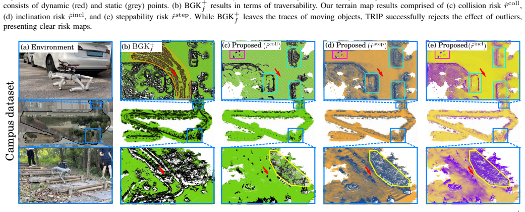
TRIP's central discovery is that traversability risk can be fed back into the terrain reconstruction itself rather than computed afterward. The standard BGK kernel infers a missing cell's height from all neighbors within a radius; TRIP instead multiplies each neighbor's weight by (1 - rstep) so that high-risk cells contribute less, and it bounds inference to regions actually observed by the sensor. The same steppability score, paired with surface verticality, defines a Mahalanobis distance against the previously updated map; cells that deviate too far are treated as dynamic-object or sensor-noise outliers and are not merged. The result is a local map that fills occluded and sparse areas without hallucinating terrain beyond walls, and a global static map that keeps traces of moving objects out. The paper reports lower mean height errors and higher collision-cell precision and accuracy than BGK-based baselines across simulated and real datasets.
Load-bearing premise
The load-bearing premise is that the steppability score rstep reliably reflects which terrain is safe in sparse, noisy, or partly occluded regions, because that same score decides both which neighbors the kernel trusts and which measurements the outlier filter rejects.
Editorial extensions
If this is right
- Online quadruped navigation can use a denser local terrain map with fewer empty cells, reducing blind spots during stair descent and traversal over box stacks.
- Collision cells near walls and unobservable regions are less likely to be hallucinated, improving the precision of navigation maps without sacrificing recall.
- Outlier traces from pedestrians, vehicles, and sensor noise are suppressed in the global static map, giving downstream planners a stable terrain representation.
- Multi-modal risks (steppability, inclination, collision) let planners distinguish visually similar but mechanically different terrain.
- The reported per-update processing times of about 9 ms in narrow scenes and 14 ms in open scenes indicate the mapping pipeline is compatible with online onboard use.
Reading between the lines
- An implication the paper leaves implicit is that the same steppability-gated kernel could be applied to learned elevation-completion methods by using a risk-weighted attention mask.
- A testable extension would be adapting the steppability-based Mahalanobis rejection as an online dynamic-object filter in SLAM backends, since it maintains a static map without requiring semantic labels for runtime.
- Because the method relies on geometric steppability rather than semantics, it may transfer to wheeled or tracked off-road robots, though the paper only evaluates quadrupeds.
- A useful sensitivity analysis we infer from the paper's logic is to corrupt rstep with increasing noise and measure whether T-BGK's advantage over vanilla BGK disappears, which would reveal how much of the gain depends on precise steppability estimates.
Signed reviews
Editorial analysis
A structured set of objections, weighed in public.
Referee Report
Summary. The paper presents TRIP, an online terrain traversability mapping pipeline for quadruped robots. It estimates steppability risk in spherical projection space, completes sparse local elevation maps with a proposed traversability-aware Bayesian generalized kernel (T-BGK), and fuses measurements into a static map via Kalman filtering with Mahalanobis-distance outlier rejection. The authors evaluate reconstruction and navigation-map metrics on the QRC simulation, SemanticKITTI sequences, and a campus dataset, comparing against BGK+ and tf-map baselines and a TRIP-S ablation.
Significance. If the described mechanisms worked as claimed, the contributions would be practically useful: dense, outlier-robust, multi-risk terrain maps for online legged navigation are an active need, and the paper includes a clear system description, public-data experiments, an ablation, and a demo video. The main mathematical claim, however, is not supported as written: the T-BGK weight cancels in the inference formula, so the risk-aware completion reduces to vanilla BGK. The empirical comparisons also report single numbers without uncertainty, so the strength of the reported gains is unclear.
major comments (3)
- [III-B, Eqs. (7)-(8)] The claimed traversability-aware inference is mathematically vacuous as written. Because kT(e_i, e) = (1 - rstep_e) k(e_i, e), the factor (1 - rstep_e) is constant over the summation index e_i and cancels between numerator and denominator in Eq. (8), yielding exactly the BGK inference L in Eq. (6). The same cancellation occurs in the bias models (11)-(12). Consequently, the T-BGK module differs from BGK only by the informally mentioned bounding of the inference region, and Eq. (8) is undefined (0/0) when rstep_e = 1. This directly contradicts the contribution statement that T-BGK enhances local terrain map completion while emphasizing traversability risks and undermines the attribution of the Table II improvements to T-BGK. Please correct the kernel so the risk weight depends on the neighbor cell (e.g., kT(e_i, e) = (1 - rstep_{e_i}) k(e_i, e)) and rerun the experiments, or state explicitly that only the bounded inference region differs and validate that mechanism separately.
- [V-B, Table II] The quantitative evaluation reports a single value per metric and sequence without variance, trials, or significance tests, although the abstract claims significant performance increases. Please provide multiple runs or error bars, and perform a statistical test or at least report per-trial results, to support the significance language. Also, the table header uses MHE while Section IV-B.2 defines MAE; the metric name should be consistent.
- [V-A, Table I] Several key parameters are set contextually: l is 0.5 m in narrow environments and 1.0 m in open ones, and tau_M is 3.0 in dynamic scenes and 1.0 in static ones. No sensitivity analysis is provided, so it is unclear whether the reported gains persist under fixed parameters or how much tuning is needed for new environments. This is important for the claimed scalability and generality of TRIP.
minor comments (5)
- [Index Terms] The Index Terms contain the typo Traversabiltiy; it should be Traversability.
- [Fig. 4 caption] The caption has Vanila BGK instead of Vanilla BGK.
- [Eq. (15)] The covariance matrix Sigma_{e(t-1)} is said to be derived from the Kalman filter update, but the text does not define which state covariance is used or how it is initialized; please specify.
- [V-A] The local completion range is 6 m x 6 m for QRC, 20 m x 20 m for campus, and 80 m x 80 m for SemanticKITTI; please state whether the same range is used for all baselines in each environment and discuss the effect on runtime comparisons in Table III.
- [V-B.1] The statement that tf-map has the lowest MTE in the QRC simulation should also note that TRIP achieves comparable MTE (7.47 cm vs. 7.13 cm) while having much higher precision, F1, and accuracy, and explain why MTE is not the sole criterion.
Circularity Check
T-BGK's risk weight cancels in Eq. (8), making the central traversability-aware inference algebraically identical to vanilla BGK.
-
renaming known result
[Section III-B, Eqs. (7)-(8); also Eqs. (11)-(12)]
"kT (eα, eβ) = (1 − rstep eβ )k(eα, eβ), (7) ... LT (K E e ) ≜ ¯ye = PKE e ei kT (ei, e)yei PKEe ei kT (ei, e) . (8)"
By Eq. (7), the kernel used in Eq. (8) is kT(ei, e) = (1 − rstep_e) k(ei, e). The factor (1 − rstep_e) depends only on the query cell e, not on the neighbor ei, so it is a common factor in every term of the numerator and denominator of Eq. (8) and cancels. Hence LT reduces exactly to the vanilla BGK inference L of Eq. (6). The same cancellation occurs in the bias models (11) and (12). Therefore the paper's stated mechanism, that risky neighbors are downweighted during terrain height inference, is not present in the equations as written; T-BGK is a renamed version of BGK.
full rationale
The paper's own equations force the central T-BGK contribution to collapse: substituting Eq. (7) into Eq. (8) gives a neighbor-independent query factor that cancels, so the T-BGK inference function is identical to the vanilla BGK inference of Eq. (6), and the bias models in Eqs. (11)-(12) collapse in the same way. This makes one of the three headline contributions vacuous by construction. The remaining contributions, spherical-projection steppability estimation and steppability-based Mahalanobis outlier rejection, are self-contained algorithm steps applied directly to sensor data and are not fitted to evaluation targets, so they are not circular. The self-citations to prior work ([29], [33]) provide algorithmic components rather than load-bearing external uniqueness claims. Because one central claimed prediction reduces by construction to the baseline while other contributions retain independent content, the appropriate circularity score is 6.
Assumptions & free parameters
free parameters (6)
- tau_r =
0.6
- h_p =
1.0 m
- tau_h =
0.25 m
- l (kernel radius) =
0.5 (narrow) / 1.0 (open)
- tau_M =
3.0 (static) / 1.0 (dynamic)
- map resolution and local completion range =
0.1/0.2 m resolution, 6/20/80 m range
assumptions (5)
- standard math BGK kernel k(eα,eβ) from Melkumyan and Ramos [32] is a valid sparse covariance function for GP-like inference.
- standard math PCA over neighboring surfel points yields reliable normals.
- domain assumption Traversability can be represented as 2.5D elevation with overhanging elements removable by a platform-height threshold.
- ad hoc to paper Steppability risk is a reliable gate for kernel inference.
- ad hoc to paper SemanticKITTI traversability ground truth is adequately defined by semantic labels plus the tau_h height-difference rule, excluding vegetation above -1.0.
Cite this review
Pith. "Pith review of TRIP: Terrain Traversability Mapping With Risk-Aware Prediction for Enhanced Online Quadrupedal Robot Navigation." pith.science (2026). https://pith.science/paper/4IBQT47V
@misc{pith2026241117134,
  author       = {Pith},
  title        = {Pith review of: TRIP: Terrain Traversability Mapping With Risk-Aware Prediction for Enhanced Online Quadrupedal Robot Navigation},
  year         = {2026},
  howpublished = {\url{https://pith.science/paper/4IBQT47V}},
  note         = {Machine review of arXiv:2411.17134}
}
read the original abstract
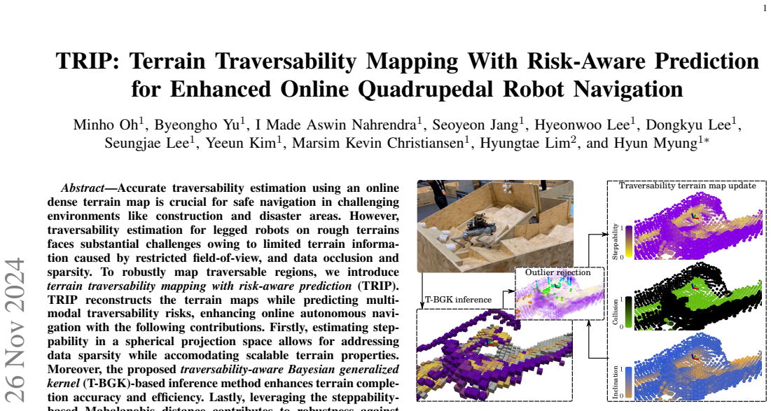
Accurate traversability estimation using an online dense terrain map is crucial for safe navigation in challenging environments like construction and disaster areas. However, traversability estimation for legged robots on rough terrains faces substantial challenges owing to limited terrain information caused by restricted field-of-view, and data occlusion and sparsity. To robustly map traversable regions, we introduce terrain traversability mapping with risk-aware prediction (TRIP). TRIP reconstructs the terrain maps while predicting multi-modal traversability risks, enhancing online autonomous navigation with the following contributions. Firstly, estimating steppability in a spherical projection space allows for addressing data sparsity while accomodating scalable terrain properties. Moreover, the proposed traversability-aware Bayesian generalized kernel (T-BGK)-based inference method enhances terrain completion accuracy and efficiency. Lastly, leveraging the steppability-based Mahalanobis distance contributes to robustness against outliers and dynamic elements, ultimately yielding a static terrain traversability map. As verified in both public and our in-house datasets, our TRIP shows significant performance increases in terms of terrain reconstruction and navigation map. A demo video that demonstrates its feasibility as an integral component within an onboard online autonomous navigation system for quadruped robots is available at https://youtu.be/d7HlqAP4l0c.
Figures


Figures from the paper (7 more)


Reference graph
Works this paper leans on
-
[1]
J. Frey, D. Hoeller, S. Khattak, and M. Hutter, “Locomotion policy guided traversability learning using volumetric representations of com- plex environments,” in Proc. IEEE/RSJ Int. Conf. Intell. Robot. Syst. , 2022, pp. 5722–5729
work page 2022
-
[2]
Per- ceptive locomotion through nonlinear model-predictive control,
R. Grandia, F. Jenelten, S. Yang, F. Farshidian, and M. Hutter, “Per- ceptive locomotion through nonlinear model-predictive control,” IEEE Trans. Robot., pp. 1–20, 2023
work page 2023
-
[3]
Elevation mapping for locomotion and navigation using GPU,
T. Miki, L. Wellhausen, R. Grandia, F. Jenelten, T. Homberger, and M. Hutter, “Elevation mapping for locomotion and navigation using GPU,” in Proc. IEEE/RSJ Int. Conf. Intell. Robot. Syst. , 2022, pp. 2273– 2280
work page 2022
-
[4]
H. Xue, H. Fu, L. Xiao, Y . Fan, D. Zhao, and B. Dai, “Traversability analysis for autonomous driving in complex environment: A LiDAR- based terrain modeling approach,” J. Field Robot. , vol. 40, no. 7, pp. 1779–1803, 2023
work page 2023
-
[5]
Probabilistic terrain mapping for mobile robots with uncertain localization,
P. Fankhauser, M. Bloesch, and M. Hutter, “Probabilistic terrain mapping for mobile robots with uncertain localization,” IEEE Robot. Automat. Lett., vol. 3, no. 4, pp. 3019–3026, 2018
work page 2018
-
[6]
Trajec- tory optimization through contacts and automatic gait discovery for quadrupeds,
M. Neunert, F. Farshidian, A. W. Winkler, and J. Buchli, “Trajec- tory optimization through contacts and automatic gait discovery for quadrupeds,” IEEE Robot. Automat. Lett. , vol. 2, no. 3, pp. 1502–1509, 2017
work page 2017
-
[7]
A. W. Winkler, C. D. Bellicoso, M. Hutter, and J. Buchli, “Gait and trajectory optimization for legged systems through phase-based end- effector parameterization,” IEEE Robot. Automat. Lett. , vol. 3, no. 3, pp. 1560–1567, 2018
work page 2018
-
[8]
An efficient locally reactive controller for safe navigation in visual teach and repeat missions,
M. Mattamala, N. Chebrolu, and M. Fallon, “An efficient locally reactive controller for safe navigation in visual teach and repeat missions,” IEEE Robot. Automat. Lett. , vol. 7, no. 2, pp. 2353–2360, 2022
work page 2022
Show all 38 references
-
[9]
iPlanner: Imperative path planning,
F. Yang, C. Wang, C. Cadena, and M. Hutter, “iPlanner: Imperative path planning,” in Robot.: Science and Syst. , 2023. [Online]. Available: 10.15607/rss.2023.xix.064
2023 doi
-
[10]
SMUG planner: A safe multi-goal planner for mobile robots in challenging environments,
C. Chen, J. Frey, P. Arm, and M. Hutter, “SMUG planner: A safe multi-goal planner for mobile robots in challenging environments,”arXiv preprint arXiv:2306.05309, 2023
2023 arXiv
-
[11]
Footstep planning for autonomous walking over rough terrain,
R. J. Griffin, G. Wiedebach, S. McCrory, S. Bertrand, I. Lee, and J. Pratt, “Footstep planning for autonomous walking over rough terrain,” in Proc. IEEE-RAS Int. Conf. Humanoid Robot. , 2019, pp. 9–16
2019
-
[12]
Detecting usable planar regions for legged robot locomotion,
S. Bertrand, I. Lee, B. Mishra, D. Calvert, J. Pratt, and R. Griffin, “Detecting usable planar regions for legged robot locomotion,” in Proc. IEEE/RSJ Int. Conf. Intell. Robots Syst. , 2020, pp. 4736–4742
2020
-
[13]
Multi-layered safety for legged robots via control barrier functions and model pre- dictive control,
R. Grandia, A. J. Taylor, A. D. Ames, and M. Hutter, “Multi-layered safety for legged robots via control barrier functions and model pre- dictive control,” in Proc. IEEE Int. Conf. Robot. Automat. , 2021, pp. 8352–8358
2021
-
[14]
Perceptive locomotion in rough terrain – online foothold optimization,
F. Jenelten, T. Miki, A. E. Vijayan, M. Bjelonic, and M. Hutter, “Perceptive locomotion in rough terrain – online foothold optimization,” IEEE Robot. Automat. Lett. , vol. 5, no. 4, pp. 5370–5376, 2020
2020
-
[15]
Vision aided dynamic exploration of unstructured terrain with a small- scale quadruped robot,
D. Kim, D. Carballo, J. Di Carlo, B. Katz, G. Bledt, B. Lim, and S. Kim, “Vision aided dynamic exploration of unstructured terrain with a small- scale quadruped robot,” in Proc. IEEE Int. Conf. Robot. Automat. , 2020, pp. 2464–2470
2020
-
[16]
Learning robust perceptive locomotion for quadrupedal robots in the wild,
T. Miki, J. Lee, J. Hwangbo, L. Wellhausen, V . Koltun, and M. Hutter, “Learning robust perceptive locomotion for quadrupedal robots in the wild,” Science Robot. , vol. 7, no. 62, p. eabk2822, 2022
2022
-
[17]
TAMOLS: Terrain-aware motion optimization for legged syst
F. Jenelten, R. Grandia, F. Farshidian, and M. Hutter, “TAMOLS: Terrain-aware motion optimization for legged syst.” IEEE Trans. Robot., vol. 38, no. 6, pp. 3395–3413, 2022
2022
-
[18]
Real-time neural dense elevation mapping for urban terrain with uncertainty estimations,
B. Yang, Q. Zhang, R. Geng, L. Wang, and M. Liu, “Real-time neural dense elevation mapping for urban terrain with uncertainty estimations,” IEEE Robot. Automat. Lett. , vol. 8, no. 2, pp. 696–703, 2023
2023
-
[19]
Vision-assisted localization and terrain reconstruction with quadruped robots,
C. Zhang, J. Zhang, J. Wu, and Q. Zhu, “Vision-assisted localization and terrain reconstruction with quadruped robots,” in Proc. IEEE/RSJ Int. Conf. Intell. Robot. Syst. , 2022, pp. 13 571–13 577
2022
-
[20]
Neural scene representation for locomotion on structured terrain,
D. Hoeller, N. Rudin, C. Choy, A. Anandkumar, and M. Hutter, “Neural scene representation for locomotion on structured terrain,” IEEE Robot. Automat. Lett. , vol. 7, no. 4, pp. 8667–8674, 2022
2022
-
[21]
Bayesian generalized kernel inference for terrain traversability mapping,
T. Shan, J. Wang, B. Englot, and K. Doherty, “Bayesian generalized kernel inference for terrain traversability mapping,” in Proc. Conf. Robot Learning, 2018
2018
-
[22]
Proba- bilistic traversability model for risk-aware motion planning in off-road environments,
X. Cai, M. Everett, L. Sharma, P. R. Osteen, and J. P. How, “Proba- bilistic traversability model for risk-aware motion planning in off-road environments,” arXiv preprint arXiv:2210.00153 , 2022
2022 arXiv
-
[23]
Risk-aware off-road navigation via a learned speed distribution map,
X. Cai, M. Everett, J. Fink, and J. P. How, “Risk-aware off-road navigation via a learned speed distribution map,” in Proc. IEEE/RSJ Int. Conf. Intell. Robot. Syst. , 2022, pp. 2931–2937
2022
-
[24]
Bayesian generalized kernel inference for occupancy map prediction,
K. Doherty, J. Wang, and B. Englot, “Bayesian generalized kernel inference for occupancy map prediction,” inProc. IEEE Int. Conf. Robot. Automat., 2017, pp. 3118–3124
2017
-
[25]
Learning-aided 3-D occupancy mapping with Bayesian generalized kernel inference,
K. Doherty, T. Shan, J. Wang, and B. Englot, “Learning-aided 3-D occupancy mapping with Bayesian generalized kernel inference,” IEEE Trans. Robot., vol. 35, no. 4, pp. 953–966, 2019
2019
-
[26]
Robot-centric elevation mapping with uncertainty estimates,
P. Fankhauser, M. Bloesch, C. Gehring, M. Hutter, and R. Siegwart, “Robot-centric elevation mapping with uncertainty estimates,” in Mob. Serv. Robot., 2014, pp. 433–440
2014
-
[27]
Navigation planning for legged robots in challenging terrain,
M. Wermelinger, P. Fankhauser, R. Diethelm, P. Krüsi, R. Siegwart, and M. Hutter, “Navigation planning for legged robots in challenging terrain,” in Proc. IEEE/RSJ Int. Conf. Intell. Robot. Syst. , 2016, pp. 1184–1189
2016
-
[28]
Fast traversability estimation for wild visual navigation,
J. Frey, M. Mattamala, N. Chebrolu, C. Cadena, M. Fallon, and M. Hutter, “Fast traversability estimation for wild visual navigation,” in Robot.: Science and Syst. , 2023. [Online]. Available: 10.15607/rss.2023.xix.054
2023 doi
-
[29]
TRA VEL: Traversable ground and above-ground object segmentation using graph representation of 3D LiDAR scans,
M. Oh, E. Jung, H. Lim, W. Song, S. Hu, E. M. Lee, J. Park, J. Kim, J. Lee, and H. Myung, “TRA VEL: Traversable ground and above-ground object segmentation using graph representation of 3D LiDAR scans,” IEEE Robot. Automat. Lett. , vol. 7, no. 3, pp. 7255–7262, 2022
2022
-
[30]
Efficient surfel-based SLAM using 3D laser range data in urban environments,
J. Behley and C. Stachniss, “Efficient surfel-based SLAM using 3D laser range data in urban environments,” in Robot.: Science Syst. , 2018. [Online]. Available: 10.15607/rss.2018.xiv.016
2018 doi
-
[31]
Patchwork: Concentric zone-based region-wise ground segmentation with ground likelihood estimation using a 3D LiDAR sensor,
H. Lim, M. Oh, and H. Myung, “Patchwork: Concentric zone-based region-wise ground segmentation with ground likelihood estimation using a 3D LiDAR sensor,” IEEE Robot. Automat. Lett. , vol. 6, no. 4, pp. 6458–6465, 2021
2021
-
[32]
A sparse covariance function for exact Gaussian process inference in large datasets,
A. Melkumyan and F. T. Ramos, “A sparse covariance function for exact Gaussian process inference in large datasets,” in Proc. Int. Joint Conf. Artif. Intell. , 2009
2009
-
[33]
DynaVINS: A visual- inertial SLAM for dynamic environments,
S. Song, H. Lim, A. J. Lee, and H. Myung, “DynaVINS: A visual- inertial SLAM for dynamic environments,” IEEE Robot. Automat. Lett. , vol. 7, no. 4, pp. 11 523–11 530, 2022. 9
2022
-
[34]
DreamWaQ: Learning robust quadrupedal locomotion with implicit terrain imagination via deep reinforcement learning,
I. M. Aswin Nahrendra, B. Yu, and H. Myung, “DreamWaQ: Learning robust quadrupedal locomotion with implicit terrain imagination via deep reinforcement learning,” in Proc. IEEE Int. Conf. Robot. Automat. , 2023, pp. 5078–5084
2023
-
[35]
Robust odometry system for quadruped robots utilizing tightly-coupled and cross-modality feature association,
K. C. Marsim, M. Oh, S. Lee, I. M. A. Nahrendra, B. Yu, and H. Myung, “Robust odometry system for quadruped robots utilizing tightly-coupled and cross-modality feature association,” under review, 2023
2023
-
[36]
Taking the first step toward autonomous quadruped robots: The Quadruped Robot Challenge at ICRA 2023 in London [competitions],
A. Jacoff, J. Jeon, O. Huke, D. Kanoulas, S. Ha, D. Kim, and H. Moon, “Taking the first step toward autonomous quadruped robots: The Quadruped Robot Challenge at ICRA 2023 in London [competitions],” IEEE Robot. Automat. Magazine , vol. 30, no. 3, p. 154–158, 2023
2023
-
[37]
SemanticKITTI: A dataset for semantic scene understand- ing of LiDAR sequences,
J. Behley, M. Garbade, A. Milioto, J. Quenzel, S. Behnke, C. Stachniss, and J. Gall, “SemanticKITTI: A dataset for semantic scene understand- ing of LiDAR sequences,” in Proc. IEEE/CVF Int. Conf. Comput. Vis. , 2019, pp. 9297–9307
2019
-
[38]
ERASOR: Egocentric ratio of pseudo occupancy-based dynamic object removal for static 3D point cloud map building,
H. Lim, S. Hwang, and H. Myung, “ERASOR: Egocentric ratio of pseudo occupancy-based dynamic object removal for static 3D point cloud map building,” IEEE Robot. Automat. Lett. , vol. 6, no. 2, pp. 2272–2279, 2021
2021
Reviewed August 12, 2026 · model on record in the stance chip above.
Discussion (0). Continue with ORCID to comment.