FL-MHSM: Spatially-adaptive Fusion and Ensemble Learning for Flood-Landslide Multi-Hazard Susceptibility Mapping at Regional Scale
Pith reviewed 2026-05-10 08:41 UTC · model grok-4.3
The pith
A mixture of experts model fuses early and late fusion outputs from spatially partitioned zones to map joint flood-landslide susceptibility while preserving local heterogeneity.
A machine-rendered reading of the paper's core claim, the machinery that carries it, and where it could break.
Core claim
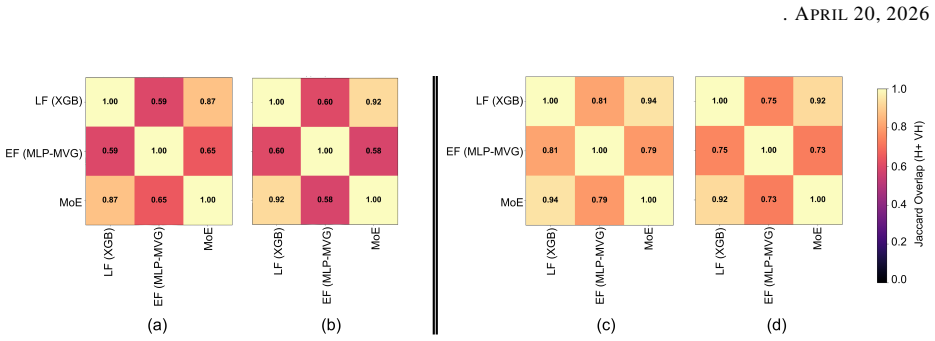
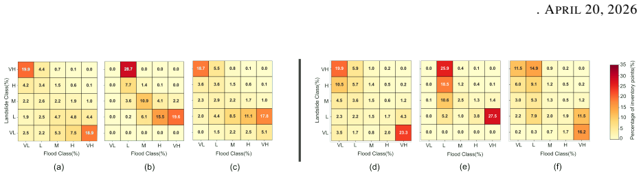
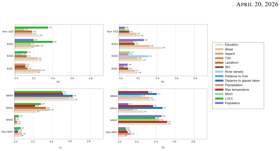
The spatially adaptive integration of early and late fusion through a soft-gating mixture of experts yields robust predictive performance for flood-landslide multi-hazard susceptibility mapping while supporting interpretable characterization of susceptibility in spatially heterogeneous landscapes, with the mixture of experts achieving AUC-ROC of 0.905 and recall of 0.930 for floods in Kerala and AUC-ROC of 0.914 and recall of 0.901 for landslides in Nepal.
What carries the argument
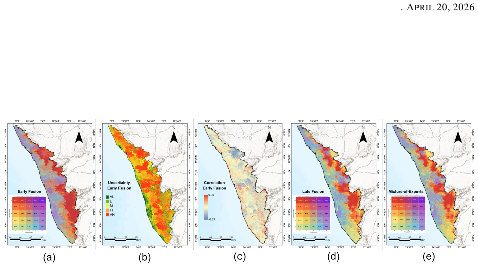
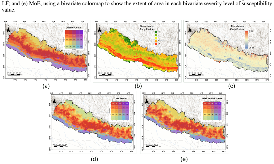
Soft-gating Mixture of Experts (MoE) model that takes outputs from probabilistic early fusion and tree-based late fusion as expert inputs and produces the final susceptibility prediction per zone.
If this is right
- Early fusion and late fusion produce complementary strengths that the mixture of experts can exploit for higher recall and lower Brier scores on flood susceptibility.
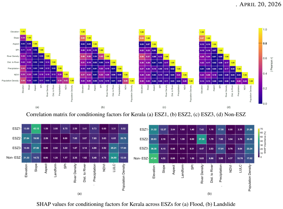
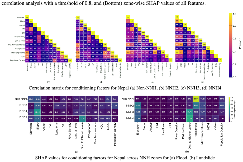
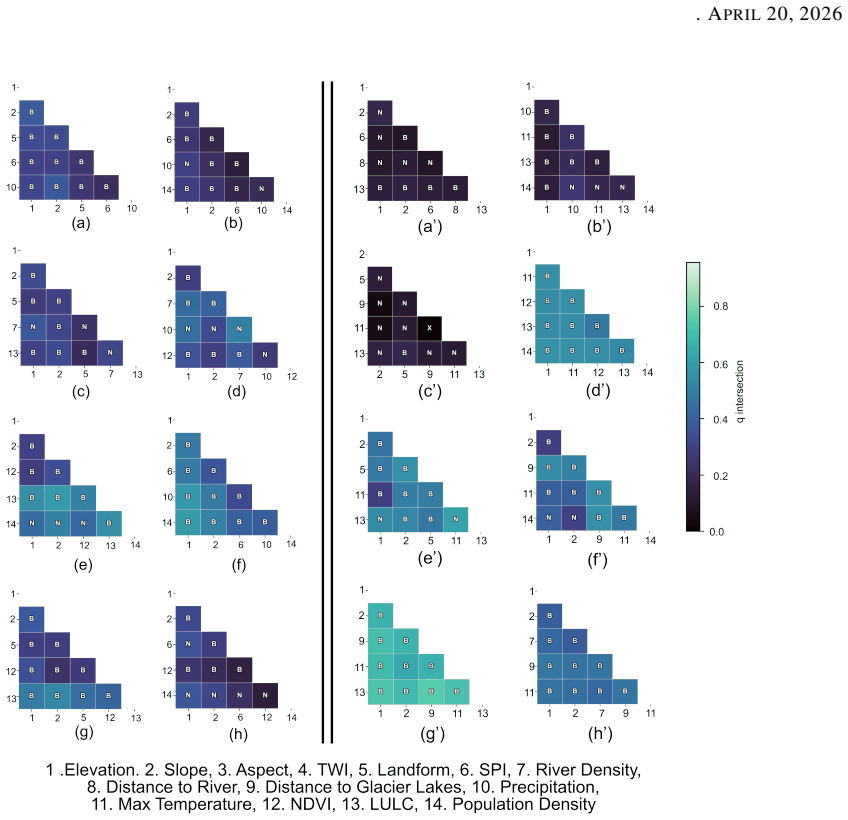
- Dominant hazard drivers can be identified per zone through GeoDetector analysis of the mixture of experts outputs, revealing topographic and land-cover controls in Kerala versus topographic and glacier controls in Nepal.
- Overlapping lattice grids allow the partitioned workflow to scale to large regional areas while maintaining spatial continuity in predictions.
- The overall design reduces reliance on a single uniform model, which the paper shows is less effective when hazards interact differently across landscapes.
Where Pith is reading between the lines
- The workflow could be extended to additional hazards by adding more experts to the mixture of experts layer without redesigning the partitioning step.
- If the zoning artifacts turn out to be minimal, the same early-late fusion pattern might apply to other spatially varying environmental risk mappings such as wildfire or drought.
Load-bearing premise
The chosen two-level spatial partitioning and the early and late fusion strategies capture cross-hazard dependence and spatial heterogeneity without creating artifacts from the zoning or partitioning decisions.
What would settle it
Running the same workflow on a third region with comparable data but different spatial scales of heterogeneity and checking whether the mixture of experts still outperforms the separate fusion methods on held-out test metrics.
Figures
read the original abstract
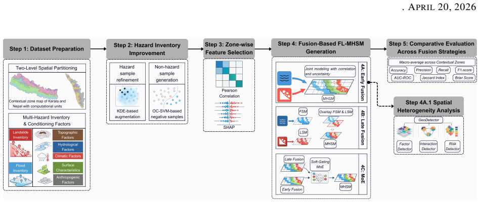
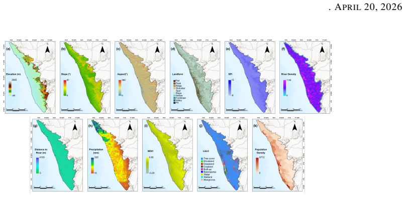
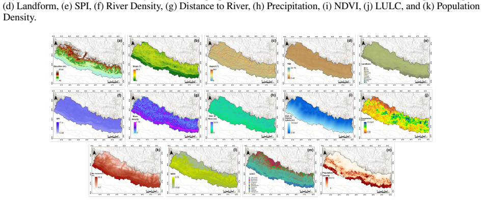
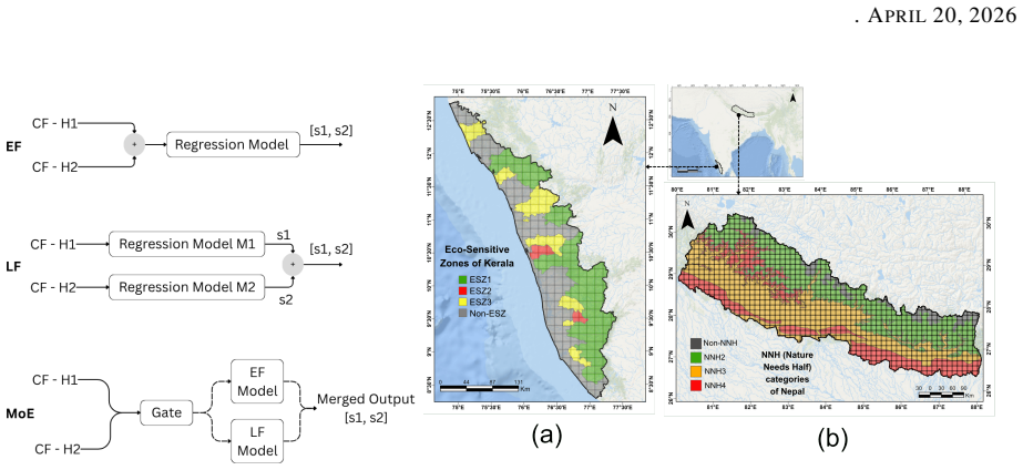
Existing multi-hazard susceptibility mapping (MHSM) studies often rely on spatially uniform models, treat hazards independently, and provide limited representation of cross-hazard dependence and uncertainty. To address these limitations, this study proposes a deep learning (DL) workflow for joint flood-landslide multi-hazard susceptibility mapping (FL-MHSM) that combines two-level spatial partitioning, probabilistic Early Fusion (EF), a tree-based Late Fusion (LF) baseline, and a soft-gating Mixture of Experts (MoE) model, with MoE serving as final predictive model. The proposed design preserves spatial heterogeneity through zonal partitions and enables data-parallel large-area prediction using overlapping lattice grids. In Kerala, EF remained competitive with LF, improving flood recall from 0.816 to 0.840 and reducing Brier score from 0.092 to 0.086, while MoE provided strongest performance for flood susceptibility, achieving an AUC-ROC of 0.905, recall of 0.930, and F1-score of 0.722. In Nepal, EF similarly improved flood recall from 0.820 to 0.858 and reduced Brier score from 0.057 to 0.049 relative to LF, while MoE outperformed both EF and LF for landslide susceptibility, achieving an AUC-ROC of 0.914, recall of 0.901, and F1-score of 0.559. GeoDetector analysis of MoE outputs further showed that dominant factors varied more across zones in Kerala, where susceptibility was shaped by different combinations of topographic, land-cover, and drainage-related controls, while Nepal showed a more consistent influence of topographic and glacier-related factors across zones. These findings show that EF and LF provide complementary predictive behavior, and that their spatially adaptive integration through MoE yields robust overall predictive performance for FL-MHSM while supporting interpretable characterization of multi-hazard susceptibility in spatially heterogeneous landscapes.
Editorial analysis
A structured set of objections, weighed in public.
Referee Report
Summary. The paper proposes a deep learning workflow for joint flood-landslide multi-hazard susceptibility mapping (FL-MHSM) at regional scale. It combines two-level spatial partitioning to preserve heterogeneity, probabilistic early fusion (EF), a tree-based late fusion (LF) baseline, and a soft-gating Mixture of Experts (MoE) model as the final predictor. The approach is evaluated on datasets from Kerala and Nepal using overlapping lattice grids for large-area prediction, with MoE reported to deliver the strongest performance (Kerala flood: AUC-ROC 0.905, recall 0.930, F1 0.722; Nepal landslide: AUC-ROC 0.914, recall 0.901, F1 0.559) and GeoDetector analysis used to characterize varying factor importance across zones.
Significance. If the performance gains and interpretability findings hold under rigorous validation, the work advances multi-hazard mapping by demonstrating how spatially adaptive fusion can address limitations of uniform models while capturing cross-hazard dependence. Concrete metric improvements (AUC-ROC, recall, F1, Brier score) over EF and LF baselines, plus the complementary behavior of the fusion strategies, represent a useful empirical contribution for regional risk assessment in heterogeneous landscapes.
major comments (2)
- [Abstract/Results] Abstract and Results sections: the central claim that MoE yields robust overall predictive performance rests on held-out test metrics, yet no details are provided on the cross-validation strategy, class-imbalance handling, or mitigation of data leakage from overlapping lattice grids; this is load-bearing because the reported gains (e.g., recall improvement from 0.816 to 0.930 in Kerala) cannot be confidently interpreted without these controls.
- [Methods] Methods (spatial partitioning and fusion description): the two-level zonal partitioning and chosen EF/LF strategies are asserted to capture spatial heterogeneity and cross-hazard dependence without artifacts, but no sensitivity analysis to partition boundaries or number of zones is reported; this directly affects the weakest assumption and the interpretability claims from the subsequent GeoDetector analysis.
minor comments (2)
- [Abstract] The abstract is information-dense; adding one sentence on dataset sizes, number of zones, or the exact MoE gating mechanism would improve immediate clarity for readers.
- [Methods] Notation for the probabilistic early fusion and soft-gating parameters could be introduced earlier or in a dedicated table to aid reproducibility.
Simulated Author's Rebuttal
We thank the referee for the constructive and detailed review of our manuscript. The comments highlight important aspects of methodological transparency and robustness that we have addressed through revisions and additional analysis.
read point-by-point responses
-
Referee: [Abstract/Results] Abstract and Results sections: the central claim that MoE yields robust overall predictive performance rests on held-out test metrics, yet no details are provided on the cross-validation strategy, class-imbalance handling, or mitigation of data leakage from overlapping lattice grids; this is load-bearing because the reported gains (e.g., recall improvement from 0.816 to 0.930 in Kerala) cannot be confidently interpreted without these controls.
Authors: We agree that these details are critical for interpreting the reported metrics. In the revised manuscript, we have added a new subsection (Section 3.4) in Methods that explicitly describes: (i) the stratified 5-fold spatial cross-validation procedure, where folds are constructed to respect zonal boundaries and ensure no spatial overlap between training and validation samples; (ii) class-imbalance handling via inverse-frequency weighting in the binary cross-entropy loss for both flood and landslide tasks; and (iii) leakage mitigation, including the use of disjoint spatial zones for training/testing and application of overlapping lattice grids solely for out-of-sample inference on the full study area. These additions directly support the validity of the performance gains (e.g., recall improvements) under controlled conditions. revision: yes
-
Referee: [Methods] Methods (spatial partitioning and fusion description): the two-level zonal partitioning and chosen EF/LF strategies are asserted to capture spatial heterogeneity and cross-hazard dependence without artifacts, but no sensitivity analysis to partition boundaries or number of zones is reported; this directly affects the weakest assumption and the interpretability claims from the subsequent GeoDetector analysis.
Authors: We acknowledge that a formal sensitivity analysis was absent from the original submission. To address this, we have conducted additional experiments (now reported in Supplementary Note S3) varying the number of zones from 4 to 12 and perturbing partition boundaries by up to 10 km. Results show that MoE AUC-ROC varies by less than 0.025 across configurations, and the dominant factors identified by GeoDetector remain consistent in rank order within each region. We have also clarified in Section 3.2 that the two-level partitioning was derived from established geographic and climatic zoning datasets for Kerala and Nepal, rather than arbitrary choices. These additions strengthen the robustness claims while preserving the interpretability of the GeoDetector results. revision: partial
Circularity Check
No circularity: empirical evaluation on held-out regional data
full rationale
The paper describes an empirical DL workflow for FL-MHSM using two-level spatial partitioning, probabilistic early fusion, tree-based late fusion, and a soft-gating MoE as the final model. Reported metrics (AUC-ROC, recall, F1-score, Brier score) are computed on held-out test data from two distinct external regions (Kerala and Nepal) using real geographic inputs. These results do not reduce to any fitted parameter by construction, self-definition, or self-citation chain; they reflect actual predictive performance on unseen data rather than renaming or tautological reuse of inputs. No equations or derivation steps in the abstract or description exhibit the enumerated circular patterns.
Axiom & Free-Parameter Ledger
free parameters (2)
- MoE gating parameters
- Zonal partition boundaries
axioms (2)
- domain assumption Flood and landslide occurrences exhibit measurable cross-hazard dependence that joint modeling can exploit.
- domain assumption Spatially uniform models fail to capture heterogeneity in large regions.
Reference graph
Works this paper leans on
-
[1]
Maneesha Vinodini Ramesh, Hari Chandana Ekkirala, Balmukund Singh, Nitin Kumar M, Sabari Ramesh, Aadityan Sridharan, Nirmala Vasudevan, and Sudesh Kumar Wadhawan. Mundakkai-Chooralmala landslide: assessment of initiation, progression, and impact.Scientific Reports, 15(1):26961, 2025
work page 2025
-
[2]
Jakob Friedrich Steiner Sudan Bikash Maharjan. The Melamchi flood disaster: Cascading hazard and the need for multihazard risk management, April 2025
work page 2025
-
[3]
United Nations Office for Disaster Risk Reduction.Global Assessment Report on Disaster Risk Reduction 2025: Resilience Pays: Financing and Investing for Our Future. Stylus Publishing, LLC, 2025
work page 2025
-
[4]
Joel C Gill and Bruce D Malamud. Reviewing and visualizing the interactions of natural hazards.Reviews of Geophysics, 52(4):680–722, 2014
work page 2014
-
[5]
Yong Piao, Dongkun Lee, Sangjin Park, Ho Gul Kim, and Yihua Jin. Multi-hazard mapping of droughts and forest fires using a multi-layer hazards approach with machine learning algorithms.Geomatics, Natural Hazards and Risk, 13(1):2649–2673, 2022
work page 2022
-
[6]
Adnanul Rehman, Jinxi Song, Fazlul Haq, Shakeel Mahmood, Muhammad Irfan Ahamad, Muhammad Basharat, Muhammad Sajid, and Muhammad Sajid Mehmood. Multi-Hazard Susceptibility Assessment Using the Analytical Hierarchy Process and Frequency Ratio Techniques in the Northwest Himalayas, Pakistan.Remote Sensing, 14(3):554, 2022
work page 2022
-
[7]
Sima Pourhashemi, Mohammad Ali Zangane Asadi, and Mahdi Boroughani. Multi-hazard susceptibility mapping in the Salt Lake watershed.Environmental Challenges, 18:101079, 2025
work page 2025
-
[8]
Kashif Ullah, Yi Wang, Zhice Fang, Lizhe Wang, and Mahfuzur Rahman. Multi-hazard susceptibility mapping based on Convolutional Neural Networks.Geoscience Frontiers, 13(5):101425, 2022
work page 2022
-
[9]
Mojgan Bordbar, Hossein Aghamohammadi, Hamid Reza Pourghasemi, and Zahra Azizi. Multi-hazard spatial modeling via ensembles of machine learning and meta-heuristic techniques.Scientific Reports, 12(1):1451, 2022
work page 2022
-
[10]
Changju Kim, Soonchan Park, and Heechan Han. Multi-Hazard Susceptibility Mapping Using Machine Learning Approaches: A Case Study of South Korea.Remote Sensing, 17(10):1660, 2025
work page 2025
-
[11]
Angelly de Jesus Pugliese Viloria, Andrea Folini, Daniela Carrion, and Maria Antonia Brovelli. Hazard Sus- ceptibility Mapping with Machine and Deep Learning: A Literature Review.Remote Sensing, 16(18):3374, 2024
work page 2024
-
[12]
Aloïs Tilloy, Bruce D Malamud, Hugo Winter, and Amélie Joly-Laugel. A review of quantification methodologies for multi-hazard interrelationships.Earth-Science Reviews, 196:102881, 2019
work page 2019
-
[13]
Yange Li, Xintong Liu, Zheng Han, and Jie Dou. Spatial Proximity-Based Geographically Weighted Regression Model for Landslide Susceptibility Assessment: A Case Study of Qingchuan Area, China.Applied Sciences, 10(3):1107, 2020
work page 2020
-
[14]
Yan-Rui Dai and Zheng-Guang Chen. Multi-Output Gaussian Process Regression for Rapid Multi-Nutrient Prediction in Soil Using Near-Infrared Spectroscopy.Agriculture, 16(4):485, 2026
work page 2026
-
[15]
Kishore Chandra Swain, Chiranjit Singha, and Laxmikanta Nayak. Flood Susceptibility Mapping through the GIS-AHP Technique Using the Cloud.ISPRS International Journal of Geo-Information, 9(12):720, 2020
work page 2020
-
[16]
Dimitrios Myronidis, Charalambos Papageorgiou, and Stavros Theophanous. Landslide susceptibility mapping based on landslide history and analytic hierarchy process (AHP).Natural Hazards, 81(1):245–263, 2016
work page 2016
-
[17]
Hamid Reza Pourghasemi, Biswajeet Pradhan, and Candan Gokceoglu. Application of fuzzy logic and analytical hierarchy process (AHP) to landslide susceptibility mapping at Haraz watershed, Iran.Natural hazards, 63(2):965– 996, 2012
work page 2012
-
[18]
Amin Salehpour Jam, Jamal Mosaffaie, Faramarz Sarfaraz, Samad Shadfar, and Rouhangiz Akhtari. GIS-based landslide susceptibility mapping using hybrid MCDM models.Natural Hazards, 108(1):1025–1046, 2021
work page 2021
-
[19]
Hüseyin Akay. Flood hazards susceptibility mapping using statistical, fuzzy logic, and MCDM methods.Soft Computing, 25(14):9325–9346, 2021. 28 . APRIL20, 2026
work page 2021
-
[20]
Thangavelu Arumugam, Sapna Kinattinkara, Sampathkumar Velusamy, Manoj Shanmugamoorthy, and Sakthivel Murugan. GIS based landslide susceptibility mapping and assessment using weighted overlay method in Wayanad: A part of Western Ghats, Kerala.Urban Climate, 49:101508, 2023
work page 2023
-
[21]
Omid Rahmati, Hamid Reza Pourghasemi, and Hossein Zeinivand. Flood susceptibility mapping using frequency ratio and weights-of-evidence models in the Golastan Province, Iran.Geocarto International, 31(1):42–70, 2016
work page 2016
-
[22]
V Vakhshoori and M Zare. Landslide susceptibility mapping by comparing weight of evidence, fuzzy logic, and frequency ratio methods.Geomatics, Natural Hazards and Risk, 7(5):1731–1752, 2016
work page 2016
-
[23]
Rui-Xuan Tang, E-Chuan Yan, Tao Wen, Xiao-Meng Yin, and Wei Tang. Comparison of Logistic Regression, Information Value, and Comprehensive Evaluating Model for Landslide Susceptibility Mapping.Sustainability, 13(7):3803, 2021
work page 2021
-
[24]
Khabat Khosravi, Hamid Reza Pourghasemi, Kamran Chapi, and Masoumeh Bahri. Flash flood susceptibility analysis and its mapping using different bivariate models in Iran: a comparison between Shannon’s entropy, statistical index, and weighting factor models.Environmental Monitoring and Assessment, 188(12):656, 2016
work page 2016
-
[25]
Taskin Kavzoglu, Emrehan Kutlug Sahin, and Ismail Colkesen. Landslide susceptibility mapping using GIS-based multi-criteria decision analysis, support vector machines, and logistic regression.Landslides, 11(3):425–439, 2014
work page 2014
-
[26]
Cahio Guimarães Seabra Eiras, Juliana Ribeiro Gonçalves de Souza, Renata Delicio Andrade de Freitas, César Fal- cão Barella, and Tiago Martins Pereira. Discriminant analysis as an efficient method for landslide susceptibility assessment in cities with the scarcity of predisposition data.Natural hazards, 107(2):1427–1442, 2021
work page 2021
-
[27]
Kumudu Madhawa Kurugama, So Kazama, Yusuke Hiraga, and Chaminda Samarasuriya. A comparative spatial analysis of flood susceptibility mapping using boosting machine learning algorithms in Rathnapura, Sri Lanka. Journal of Flood Risk Management, 17(2):e12980, 2024
work page 2024
-
[28]
Moziihrii Ado, Khwairakpam Amitab, Arnab Kumar Maji, El˙zbieta Jasi´nska, Radomir Gono, Zbigniew Leonowicz, and Michał Jasi´nski. Landslide Susceptibility Mapping Using Machine Learning: A Literature Survey.Remote Sensing, 14(13):3029, 2022
work page 2022
-
[29]
Seyd Teymoor Seydi, Yousef Kanani-Sadat, Mahdi Hasanlou, Roya Sahraei, Jocelyn Chanussot, and Meisam Amani. Comparison of Machine Learning Algorithms for Flood Susceptibility Mapping.Remote Sensing, 15(1):192, 2022
work page 2022
-
[30]
Ziya Usta, Halil Akıncı, and Alper Tunga Akın. Comparison of tree-based ensemble learning algorithms for landslide susceptibility mapping in Murgul (Artvin), Turkey.Earth Science Informatics, 17(2):1459–1481, 2024
work page 2024
-
[31]
Abbas Abbaszadeh Shahri, Johan Spross, Fredrik Johansson, and Stefan Larsson. Landslide susceptibility hazard map in southwest Sweden using artificial neural network.Catena, 183:104225, 2019
work page 2019
-
[32]
Siti Norsakinah Selamat, Nuriah Abd Majid, Mohd Raihan Taha, and Ashraf Osman. Landslide Susceptibility Model Using Artificial Neural Network (ANN) Approach in Langat River Basin, Selangor, Malaysia.Land, 11(6):833, 2022
work page 2022
-
[33]
Nanda Khoirunisa, Cheng-Yu Ku, and Chih-Yu Liu. A GIS-Based Artificial Neural Network Model for Flood Susceptibility Assessment.International Journal of Environmental Research and Public Health, 18(3):1072, 2021
work page 2021
-
[34]
Xudong Hu, Han Zhang, Hongbo Mei, Dunhui Xiao, Yuanyuan Li, and Mengdi Li. Landslide Susceptibility Mapping Using the Stacking Ensemble Machine Learning Method in Lushui, Southwest China.Applied Sciences, 10(11):4016, 2020
work page 2020
-
[35]
Prima Riza Kadavi, Chang-Wook Lee, and Saro Lee. Application of Ensemble-Based Machine Learning Models to Landslide Susceptibility Mapping.Remote Sensing, 10(8):1252, 2018
work page 2018
-
[36]
Mahyat Shafapour Tehrany, Biswajeet Pradhan, and Mustafa Neamah Jebur. Flood susceptibility mapping using a novel ensemble weights-of-evidence and support vector machine models in GIS.Journal of Hydrology, 512:332–343, 2014
work page 2014
-
[37]
Abu Reza Md Towfiqul Islam, Swapan Talukdar, Susanta Mahato, Sonali Kundu, Kutub Uddin Eibek, Quoc Bao Pham, Alban Kuriqi, and Nguyen Thi Thuy Linh. Flood susceptibility modelling using advanced ensemble machine learning models.Geoscience Frontiers, 12(3):101075, 2021
work page 2021
-
[38]
Hossein Shafizadeh-Moghadam, Roozbeh Valavi, Himan Shahabi, Kamran Chapi, and Ataollah Shirzadi. Novel forecasting approaches using combination of machine learning and statistical models for flood susceptibility mapping.Journal of Environmental Management, 217:1–11, 2018. 29 . APRIL20, 2026
work page 2018
-
[39]
Ionut Cristi Nicu, Letizia Elia, Lena Rubensdotter, Hakan Tanya¸ s, and Luigi Lombardo. Multi-hazard susceptibility mapping of cryospheric hazards in a high-Arctic environment: Svalbard Archipelago.Earth System Science Data, 15(1):447–464, 2023
work page 2023
-
[40]
Pavlos Krassakis, Andreas Karavias, Paraskevi Nomikou, Konstantinos Karantzalos, Nikolaos Koukouzas, Ioannis Athinelis, Stavroula Kazana, and Issaak Parcharidis. Multi-Hazard Susceptibility Assessment Using the Analytical Hierarchy Process in Coastal Regions of South Aegean V olcanic Arc Islands.GeoHazards, 4(1):77–106, 2023
work page 2023
-
[41]
Bofan Yu, Huaixue Xing, and Jiaxing Yan. Susceptibility assessment of multi-hazards using random forest—back propagation neural network coupling model: a Hangzhou city case study.Scientific Reports, 14(1):21783, 2024
work page 2024
-
[42]
Gizem Karakas, Sultan Kocaman, and Candan Gokceoglu. A Hybrid Multi-Hazard Susceptibility Assessment Model for a Basin in Elazig Province, Türkiye.International Journal of Disaster Risk Science, 14(2):326–341, 2023
work page 2023
-
[43]
Zhao Peng, Imran Ahmad, Mithas Ahmad Dar, Mariya Belete, Mezid Kassa Abebe, Getachew Fentaw, Milashu Sisay, Zinabie Mekonnen Taye, Shewaye Amakelew, and Getanew Sewnetu Zewdu. Spatially adaptive modeling of soil erosion susceptibility using geographically weighted regression integrated with remote sensing and GIS techniques.Scientific Reports, 2025
work page 2025
-
[44]
Jingru Ma, Xiaodong Wang, and Guangxiang Yuan. Evaluation of Geological Hazard Susceptibility Based on the Regional Division Information Value Method.ISPRS International Journal of Geo-Information, 12(1):17, 2023
work page 2023
-
[45]
Qiaoli Wang, Zijun Li, Jiannan Cai, Mengsheng Zhang, Zida Liu, Yu Xu, and Rongrong Li. Spatially adaptive machine learning models for predicting water quality in Hong Kong.Journal of Hydrology, 622:129649, 2023
work page 2023
-
[46]
Zhonghai Zhao, Yan Dong, Wei Qi, Zhuo Wang, Guiwa Xu, and Jipeng Sun. The impact of spatial heterogeneity zoning and feature factor optimization on geological hazard susceptibility assessment: a case study of Qingyuan County, Liaoning Province.Geomatics, Natural Hazards and Risk, 16(1):2586179, 2025
work page 2025
-
[47]
Feifan Lu, Guifang Zhang, Tonghao Wang, Yumeng Ye, and Qinghao Zhao. Geographically Weighted Random Forest Based on Spatial Factor Optimization for the Assessment of Landslide Susceptibility.Remote Sensing, 17(9):1608, 2025
work page 2025
-
[48]
Remarks on multi-output Gaussian process regression.Knowledge- Based Systems, 144:102–121, 2018
Haitao Liu, Jianfei Cai, and Yew-Soon Ong. Remarks on multi-output Gaussian process regression.Knowledge- Based Systems, 144:102–121, 2018
work page 2018
-
[49]
Wenlong Gong, Brian J Reich, and Howard H Chang. Multivariate spatial prediction of air pollutant concentrations with INLA.Environmental research communications, 3(10):101002, 2021
work page 2021
-
[50]
Prasanjit Dey, Soumyabrata Dev, and Bianca Schoen Phelan. Predicting Multivariate Air Pollution: A Gaussian- Mixture Nested Factorial Variational Autoencoder Approach.IEEE Geoscience and Remote Sensing Letters, 21:1–5, 2024
work page 2024
-
[51]
Devis Tuia, Jochem Verrelst, Luis Alonso, Fernando Pérez-Cruz, and Gustavo Camps-Valls. Multioutput Support Vector Regression for Remote Sensing Biophysical Parameter Estimation.IEEE Geoscience and Remote Sensing Letters, 8(4):804–808, 2011
work page 2011
-
[52]
Madhav Gadgil, BJ Krishnan, KN Ganeshaiah, VS Vijayan, Renee Borges, R Sukumar, L Noronha, VS Nayak, DK Subramaniam, RV Varna, et al. Report of the Western Ghats ecology expert panel.Submitted to the Ministry of Environment and Forests, Government of India, 2011
work page 2011
-
[53]
An Ecoregion-Based Approach to Protecting Half the Terrestrial Realm.BioScience, 67(6):534–545, 2017
Eric Dinerstein, David Olson, Anup Joshi, Carly Vynne, Neil D Burgess, Eric Wikramanayake, Nathan Hahn, Suzanne Palminteri, Prashant Hedao, Reed Noss, et al. An Ecoregion-Based Approach to Protecting Half the Terrestrial Realm.BioScience, 67(6):534–545, 2017
work page 2017
-
[54]
Lina Hao, A Rajaneesh, Cees Van Westen, KS Sajinkumar, Tapas Ranjan Martha, Pankaj Jaiswal, and Brian G McAdoo. Constructing a complete landslide inventory dataset for the 2018 monsoon disaster in Kerala, India, for land use change analysis.Earth System Science Data, 12(4):2899–2918, 2020
work page 2018
-
[55]
Caroline S Juang, Thomas A Stanley, and Dalia B Kirschbaum. Using citizen science to expand the global map of landslides: Introducing the Cooperative Open Online Landslide Repository (COOLR).PloS One, 14(7):e0218657, 2019
work page 2019
-
[56]
United Nations Office for Outer Space Affairs (UNOOSA). Recommended prac- tice: Flood mapping and damage assessment using sentinel-1 sar data in google earth engine. https://www.un-spider.org/advisory-support/recommended-practices/ recommended-practice-google-earth-engine-flood-mapping , 2019. UN-SPIDER Knowledge Portal. 30 . APRIL20, 2026
work page 2019
-
[57]
P Vijaykumar, S Abhilash, A V Sreenath, UN Athira, K Mohanakumar, BE Mapes, B Chakrapani, AK Sahai, TN Niyas, and OP Sreejith. Kerala floods in consecutive years – Its association with mesoscale cloudburst and structural changes in monsoon clouds over the west coast of India.Weather and Climate Extremes, 33:100339, 2021
work page 2021
-
[58]
Sunwi Maskey, Rijan Bhakta Kayastha, and Rakesh Kayastha. Glacial Lakes Outburst Floods (GLOFs) modelling of Thulagi and Lower Barun Glacial Lakes of Nepalese Himalaya.Progress in Disaster Science, 7:100106, 2020
work page 2020
-
[59]
Jiayu Hu, Xiaojun Yao, Hongyu Duan, Yuan Zhang, Yu Wang, and Tongyu Wu. Temporal and Spatial Changes and GLOF Susceptibility Assessment of Glacial Lakes in Nepal from 2000 to 2020.Remote Sensing, 14(19):5034, 2022
work page 2000
-
[60]
Parameters and methods used in flood susceptibility mapping: a review
Cagla Melisa Kaya and Leyla Derin. Parameters and methods used in flood susceptibility mapping: a review. Journal of Water and Climate Change, 14(6):1935–1960, 2023
work page 1935
-
[61]
Scaling up Study Area Size in Flood Susceptibility Mapping
Aswathi Mundayatt and Jaya Sreevalsan-Nair. Scaling up Study Area Size in Flood Susceptibility Mapping. In Proceedings of 2024 IEEE International Geoscience and Remote Sensing Symposium (IGARSS), pages 3211–3214. IEEE, 2024
work page 2024
-
[62]
Xinyue Fan, Bin Liu, Jie Luo, Ke Pan, Suyue Han, and Zhongli Zhou. Comparison of earthquake-induced shallow landslide susceptibility assessment based on two-category LR and KDE-MLR.Scientific Reports, 13(1):833, 2023
work page 2023
-
[63]
Yang Li, Yutian Lei, Bo Chen, and Jiale Chen. Evaluation of geological hazard susceptibility based on the multi-kernel density information method.Scientific Reports, 15(1):7892, 2025
work page 2025
-
[64]
Chengming Ye, Rong Tang, Ruilong Wei, Zixuan Guo, and Huajun Zhang. Generating accurate negative samples for landslide susceptibility mapping: A combined self-organizing-map and one-class SVM method.Frontiers in Earth Science, 10:1054027, 2023
work page 2023
-
[65]
Shuai Chen, Zelang Miao, Lixin Wu, Anshu Zhang, Qirong Li, and Yueguang He. A One-Class-Classifier-Based Negative Data Generation Method for Rapid Earthquake-Induced Landslide Susceptibility Mapping.Frontiers in Earth Science, 9:609896, 2021
work page 2021
-
[66]
Saleh Yousefi, Hamid Reza Pourghasemi, Sayed Naeim Emami, Omid Rahmati, Shahla Tavangar, Soheila Pouyan, John P Tiefenbacher, Shahbaz Shamsoddini, and Mohammad Nekoeimehr. Assessing the susceptibility of schools to flood events in Iran.Scientific Reports, 10(1):18114, 2020
work page 2020
-
[67]
Robert M O’brien. A Caution Regarding Rules of Thumb for Variance Inflation Factors.Quality & Quantity, 41(5):673–690, 2007
work page 2007
-
[68]
Scott M Lundberg and Su-In Lee. A unified approach to interpreting model predictions.Advances in Neural Information Processing Systems, 30, 2017
work page 2017
-
[69]
Husam Al-Najjar, Bahareh Kalantar, Biswajeet Pradhan, Ghassan Beydoun, and Naonori Ueda. SHapley Additive exPlanations (SHAP) for Landslide Susceptibility Models: Shedding Light on Explainable AI.ISPRS Annals of the Photogrammetry, Remote Sensing and Spatial Information Sciences, pages 81–85, 2025
work page 2025
-
[70]
Muhammad Sakib Khan Inan and Istiakur Rahman. Explainable AI Integrated Feature Selection for Landslide Susceptibility Mapping Using TreeSHAP.SN Computer Science, 4(5):482, 2023
work page 2023
-
[71]
Christopher M Bishop and Nasser M Nasrabadi.Pattern Recognition and Machine Learning, volume 4. Springer, 2006
work page 2006
-
[72]
Woo-Joo Choi and Myongkyoon Yang. Probabilistic Deep Learning Framework for Greenhouse Microclimate Prediction with Time-Varying Uncertainty and Covariance Analysis.Agriculture, 15(23):2461, 2025
work page 2025
-
[73]
Francesco Zanetta, Daniele Nerini, Matteo Buzzi, and Henry Moss. Efficient Modeling of Subkilometer Surface Wind with Gaussian Processes and Neural Networks.Artificial Intelligence for the Earth Systems, 2025
work page 2025
-
[74]
Rahebeh Abedi, Romulus Costache, Hossein Shafizadeh-Moghadam, and Quoc Bao Pham. Flash-flood sus- ceptibility mapping based on XGBoost, random forest and boosted regression trees.Geocarto International, 37(19):5479–5496, 2022
work page 2022
-
[75]
Adaptive Mixtures of Local Experts
Robert A Jacobs, Michael I Jordan, Steven J Nowlan, and Geoffrey E Hinton. Adaptive Mixtures of Local Experts. Neural Computation, 3(1):79–87, 1991
work page 1991
-
[76]
Jinfeng Wang, Robert Haining, Tonglin Zhang, Chengdong Xu, Maogui Hu, Qian Yin, Lianfa Li, Chenghu Zhou, Guangquan Li, and Hongyan Chen. Statistical Modeling of Spatially Stratified Heterogeneous Data.Annals of the American Association of Geographers, 114(3):499–519, 2024
work page 2024
-
[77]
Yiran Yao and Yimin Lu. Heterogeneous Ensemble Landslide Susceptibility Assessment Method Considering Spatial Heterogeneity.Remote Sensing, 17(21):3639, 2025. 31 . APRIL20, 2026
work page 2025
-
[78]
Leilei Li, Mingzhen Jia, Chong Xu, Yingying Tian, Siyuan Ma, and Jintao Yang. Enhancing Landslide Suscepti- bility Mapping by Integrating Neighboring Information in Slope Units: A Spatial Logistic Regression.Remote Sensing, 16(23):4475, 2024
work page 2024
-
[79]
Jin-Feng Wang, Xin-Hu Li, George Christakos, Yi-Lan Liao, Tin Zhang, Xue Gu, and Xiao-Ying Zheng. Geo- graphical Detectors-Based Health Risk Assessment and its Application in the Neural Tube Defects Study of the Heshun Region, China.International Journal of Geographical Information Science, 24(1):107–127, 2010
work page 2010
-
[80]
Jiarong Liang, Wenwen Qi, Chong Xu, Peng Wang, Jingjing Sun, Xuewei Zhang, Zhiwen Xue, Jingyu Chen, Yulong Cui, Junwei Pan, et al. Evaluation of geological hazards susceptibility along a key railway based on machine learning.Scientific Reports, 15(1):42497, 2025
work page 2025
discussion (0)
Sign in with ORCID, Apple, or X to comment. Anyone can read and Pith papers without signing in.