Towards Generalizable Mapping of Hedges and Linear Woody Features from Earth Observation Data: a national Product for Germany
Pith reviewed 2026-05-25 06:20 UTC · model grok-4.3
The pith
A single neural network separates linear woody features from binary masks created from varied Earth observation inputs.
A machine-rendered reading of the paper's core claim, the machinery that carries it, and where it could break.
Core claim
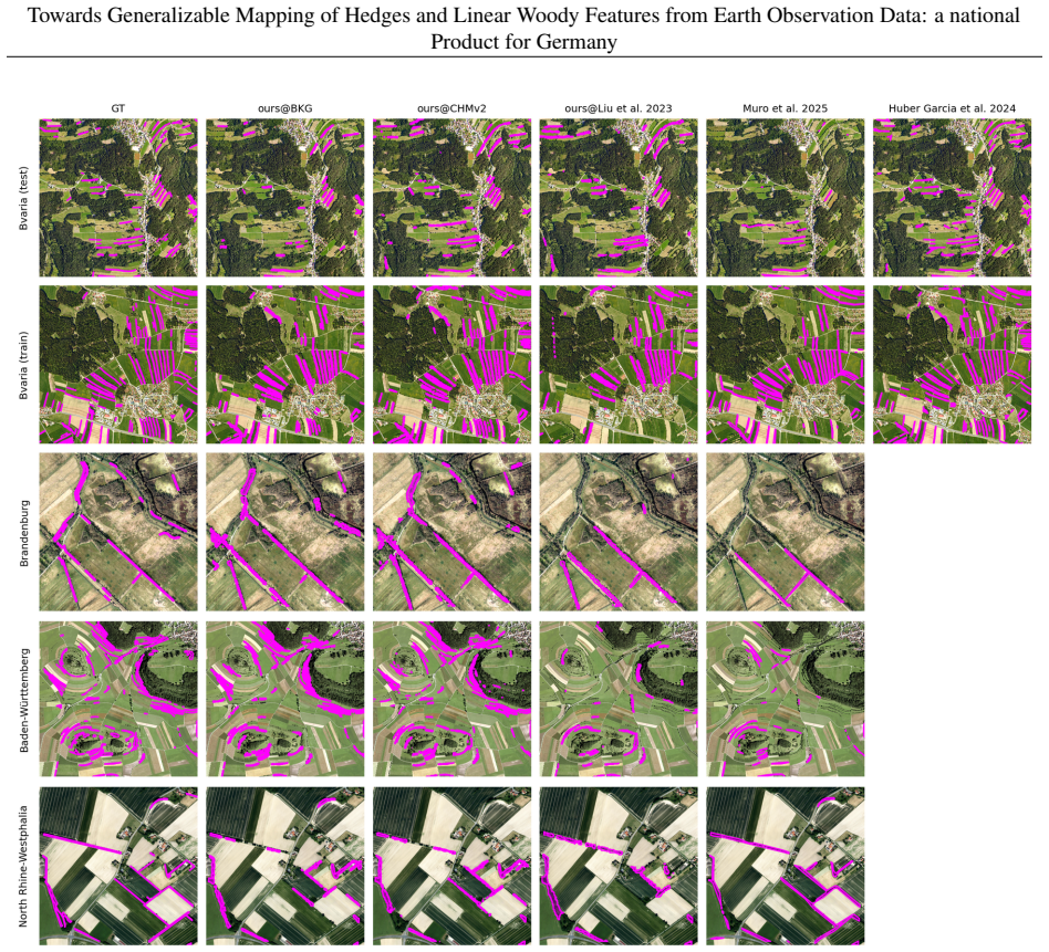
The workflow uses two independently optimizable parts: a flexible input interface that consolidates diverse Earth observation data into a binary woody vegetation mask, and a deep neural network trained to separate linear from non-linear shapes in the mask. A single model trained once derives three national-scale linear woody feature maps for Germany from 0.73 m, 1 m, and 3 m resolution sources, with results competitive against refined biotope mapping references and two prior maps across evaluation sites.
What carries the argument
The modular workflow consisting of a flexible input data interface that produces a binary woody vegetation mask, followed by a deep neural network that separates linear from non-linear shapes within the mask.
If this is right
- National-scale linear woody feature maps can be generated from multiple spatial resolutions using one model without retraining.
- The approach yields results competitive with refined reference data from multiple federal state biotope campaigns and with two existing maps.
- The modular structure supports extension to other regions with comparable data diversity and landscape variability.
- Such mapping directly informs management and preservation of hedges for ecosystem services in agricultural areas.
Where Pith is reading between the lines
- The binary mask intermediate step likely reduces sensor-specific variations to aid cross-resolution generalization.
- The same structure could be adapted to map other linear landscape elements such as field boundaries or watercourses.
- Testing the model on data from countries outside Germany with similar agricultural patterns would check broader transferability.
- Adding multi-temporal inputs to the mask creation step might further stabilize performance under changing acquisition conditions.
Load-bearing premise
That consolidating heterogeneous Earth observation data into a binary woody vegetation mask preserves the shape information needed for a neural network to accurately separate linear from non-linear features across different landscapes and conditions without retraining.
What would settle it
If applying the single trained model to a new input resolution or unseen landscape region produces maps whose accuracy falls substantially below the reported competitive level when checked against independent reference data from biotope surveys.
Figures


read the original abstract
Hedges and other linear woody features provide valuable ecosystem services, particularly within intensively managed agricultural landscapes. They are key elements for climate adaptation and biodiversity amongst others not only due to a largely varying flora, but also as a feeding-, resting-, and nesting place for many animals and insects including valuable pollinators. Therefore, they require dedicated management, preservation, and attention. Thus, systematic and large-scale mapping of these features from Earth observation data is of high importance. However, transferable and reusable workflows for linear woody feature mapping remain a key methodological challenge, given the diversity of sensor types, spatial resolutions, data acquisition conditions, and complex landscape variability encountered across study areas. We introduce a modular workflow built around two independently optimizable components. Firstly, a flexible input data interface that consolidates heterogeneous Earth observation data into a binary woody vegetation mask, and secondly, a deep neural network trained to separate linear from non-linear shapes within these masks. We demonstrate the workflow by deriving three national-scale linear woody feature maps for all of Germany from three input sources with 0.73 m, 1 m and 3 m spatial resolution, respectively, by using a single trained model without retraining. Evaluation against refined reference data from four federal state biotope mapping campaigns and comparison with two existing linear woody feature maps demonstrate that the workflow produces competitive results across all evaluation sites on a national level. The modular design and its demonstrated applicability at national scale provide a foundation for scalable and generalizable linear woody feature mapping beyond Germany.
Editorial analysis
A structured set of objections, weighed in public.
Referee Report
Summary. The paper claims to introduce a modular workflow for mapping hedges and linear woody features from Earth observation data at national scale. The workflow has a flexible interface to create binary woody vegetation masks from heterogeneous inputs and a DNN to separate linear from non-linear shapes. A single trained model is used to generate three national maps for Germany from 0.73 m, 1 m, and 3 m resolution data without retraining, with competitive results against biotope mapping reference data.
Significance. If the results hold, the modular workflow could be significant for enabling scalable, generalizable mapping of linear woody features across diverse data sources and resolutions, supporting ecosystem service assessments and biodiversity monitoring at national levels. The use of independent reference data is a positive aspect.
major comments (2)
- The central claim of cross-resolution generalization without retraining (Abstract) depends on the binary woody vegetation mask preserving linear topology sufficiently for the fixed DNN. At 3 m resolution, features narrower than one pixel may reduce to isolated or disconnected pixels, qualitatively altering connectivity and aspect ratio relative to 0.73 m inputs. The manuscript provides no ablation isolating this effect, such as comparing native 3 m masks versus downsampled 0.73 m masks fed to the identical network.
- The abstract reports competitive national-level results against independent reference data from four federal state biotope mapping campaigns but provides no quantitative metrics, error analysis, or details on training/evaluation protocols. This absence makes it impossible to verify the strength of the cross-site and cross-resolution claims.
minor comments (1)
- The abstract would be strengthened by including at least one key quantitative result (e.g., an F1 score or IoU value) to support the competitiveness claim.
Simulated Author's Rebuttal
We thank the referee for the constructive comments, which help clarify the presentation of our cross-resolution generalization results. We address each major comment below and will revise the manuscript to strengthen the supporting evidence where needed.
read point-by-point responses
-
Referee: The central claim of cross-resolution generalization without retraining (Abstract) depends on the binary woody vegetation mask preserving linear topology sufficiently for the fixed DNN. At 3 m resolution, features narrower than one pixel may reduce to isolated or disconnected pixels, qualitatively altering connectivity and aspect ratio relative to 0.73 m inputs. The manuscript provides no ablation isolating this effect, such as comparing native 3 m masks versus downsampled 0.73 m masks fed to the identical network.
Authors: We agree that an explicit ablation isolating the contribution of the binary mask at native 3 m resolution versus downsampled higher-resolution inputs would provide stronger support for the generalization claim. The current workflow applies the same mask-generation procedure across sources to maintain consistency, and the DNN was trained on diverse linear and non-linear shapes extracted from multiple resolutions; however, the suggested ablation was not performed. We will add this analysis in the revised manuscript, including quantitative comparison of topology metrics (e.g., connectivity and aspect ratio) before and after the DNN stage. revision: yes
-
Referee: The abstract reports competitive national-level results against independent reference data from four federal state biotope mapping campaigns but provides no quantitative metrics, error analysis, or details on training/evaluation protocols. This absence makes it impossible to verify the strength of the cross-site and cross-resolution claims.
Authors: The abstract follows the conventional high-level summary style and therefore omits specific numbers. All quantitative metrics (precision, recall, F1, and spatial agreement), error analysis, training protocols, and evaluation details against the four independent biotope-mapping datasets are reported in the results and methods sections of the full manuscript, along with comparisons to two existing maps. To address the referee's concern about verifiability from the abstract alone, we will incorporate the key national-scale performance figures into the abstract in the revision. revision: partial
Circularity Check
No circularity: empirical ML workflow with external validation
full rationale
The paper describes a modular empirical pipeline (binary mask generation from heterogeneous EO inputs followed by a fixed DNN for linear/non-linear separation) trained once and applied to three resolutions. All performance claims rest on evaluation against independent biotope mapping reference data from four federal states plus comparison to two external maps. No equations, fitted parameters, or self-citations are invoked as load-bearing derivations; the workflow is self-contained against external benchmarks and does not reduce any result to its own inputs by construction.
Axiom & Free-Parameter Ledger
axioms (2)
- domain assumption Heterogeneous Earth observation data from different sensors and resolutions can be consolidated into a reliable binary woody vegetation mask without loss of critical shape information.
- domain assumption A deep neural network trained on vegetation masks can separate linear from non-linear shapes in a manner that generalizes across landscapes, acquisition conditions, and input resolutions without retraining.
Reference graph
Works this paper leans on
-
[1]
URL https://www.sciencedirect.com/science/ article/pii/S0167880999001231
doi:https://doi.org/10.1016/S0167-8809(99)00123-1. URL https://www.sciencedirect.com/science/ article/pii/S0167880999001231. J. R. Brandle, L. Hodges, and X. H. Zhou. Windbreaks in north american agricultural systems.Agroforestry Systems, 61(1):65–78, 7 2004. ISSN 1572-9680. doi:10.1023/B:AGFO.0000028990.31801.62. URL https: //doi.org/10.1023/B:AGFO.00000...
-
[2]
Julie Betbeder, Jean Nabucet, Eric Pottier, Jacques Baudry, Samuel Corgne, and Laurence Hubert-Moy
doi:10.1109/IGARSS.2013.6723533. Julie Betbeder, Jean Nabucet, Eric Pottier, Jacques Baudry, Samuel Corgne, and Laurence Hubert-Moy. Detection and characterization of hedgerows using terrasar-x imagery.Remote Sensing, 6(5):3752–3769, 2014. ISSN 2072-4292. doi:10.3390/rs6053752. URLhttps://www.mdpi.com/2072-4292/6/5/3752. Kevin Tansey, Ian Chambers, Andrew...
-
[3]
doi:https://doi.org/10.1016/j.isprsjprs.2015.09.007
ISSN 0924-2716. doi:https://doi.org/10.1016/j.isprsjprs.2015.09.007. URL https://www.sciencedirect. com/science/article/pii/S0924271615002087. Verena Huber-García, Jennifer Kriese, Sarah Asam, Mariel Dirscherl, Michael Stellmach, Johanna Buchner, Kris- tel Kerler, and Ursula Gessner. Hedgerow map of bavaria, germany, based on orthophotos and convolutional...
-
[4]
URL https://zslpublications.onlinelibrary.wiley.com/ doi/abs/10.1002/rse2.432
doi:https://doi.org/10.1002/rse2.432. URL https://zslpublications.onlinelibrary.wiley.com/ doi/abs/10.1002/rse2.432. Richard K. Broughton, Rich J. Burkmar, Morag E. McCracken, Nadine Mitschunas, Lisa R. Norton, Denise W. Pallett, Justine Patton, John W. Redhead, Jo T. Staley, Claire M. Wood, and Richard F. Pywell. A lidar based national model of hedgerows...
-
[5]
doi:https://doi.org/10.1016/j.jenvman.2025.126705
ISSN 0301-4797. doi:https://doi.org/10.1016/j.jenvman.2025.126705. URL https://www.sciencedirect. com/science/article/pii/S0301479725026817. Michelangelo Conserva, Alex Wilson, Charlotte Stanton, Vishal Batchu, and Varun Gulshan. Mapping farmed landscapes from remote sensing.arXiv preprint, abs/2506.13993, 2025. URL https://arxiv.org/abs/2506. 13993. Anna...
-
[6]
doi:https://doi.org/10.1016/j.rse.2023.113888
ISSN 0034-4257. doi:https://doi.org/10.1016/j.rse.2023.113888. URL https://www.sciencedirect.com/ science/article/pii/S003442572300439X. Oriane Siméoni, Huy V . V o, Maximilian Seitzer, Federico Baldassarre, Maxime Oquab, Cijo Jose, Vasil Khalidov, Marc Szafraniec, Seungeun Yi, Michaël Ramamonjisoa, Francisco Massa, Daniel Haziza, Luca Wehrstedt, Jianyuan...
-
[7]
PyTorch: An Imperative Style, High-Performance Deep Learning Library
URLhttps://arxiv.org/abs/1912.01703. Ilya Loshchilov and Frank Hutter. Decoupled weight decay regularization.arXiv preprint arXiv:1711.05101, 2019. URLhttps://arxiv.org/abs/1711.05101. Ilya Loshchilov and Frank Hutter. SGDR: Stochastic gradient descent with warm restarts.arXiv preprint arXiv:1608.03983, 2017. URLhttps://arxiv.org/abs/1608.03983. Zengqiang...
work page internal anchor Pith review Pith/arXiv arXiv doi:10.1109/tmi.2017.2778748 1912
-
[8]
URL https://www.bdvi.de/application/files/8716/9565/1129/FORUM_3-2023_Digitaler_ Zwilling.pdf. 31
discussion (0)
Sign in with ORCID, Apple, or X to comment. Anyone can read and Pith papers without signing in.