RO-LiDAR GeoQuickView: A Web Platform for Exploring Public LiDAR-Derived Elevation Data in Romania
Pith reviewed 2026-06-27 17:07 UTC · model grok-4.3
The pith
A voluntary web platform integrates Romania's public LiDAR elevation data with standardized hillshade views and direct raster access.
A machine-rendered reading of the paper's core claim, the machinery that carries it, and where it could break.
Core claim
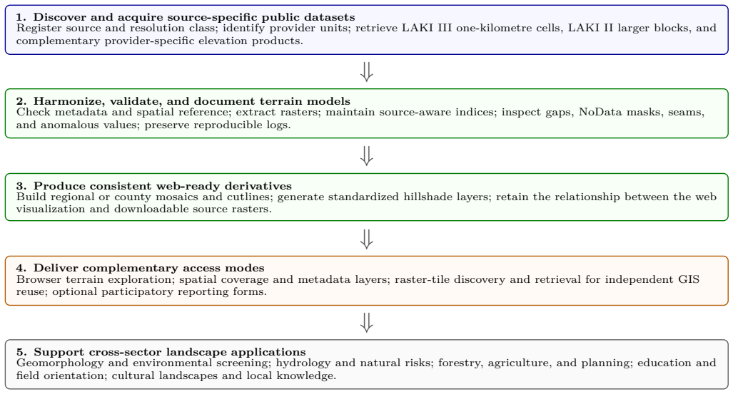
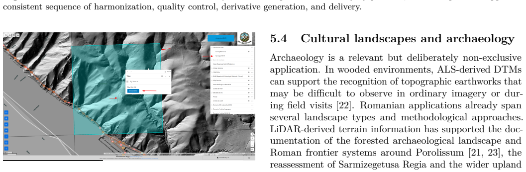
RO-LiDAR GeoQuickView integrates LiDAR-derived digital terrain models and complementary elevation models of different resolutions, publishes standardized hillshade visualizations for immediate browser access, supports participatory landscape documentation, and provides a spatial index for direct raster retrieval, acting as an accessibility layer over public data infrastructures in Romania.
What carries the argument
The source-aware harmonization and quality-control workflow that merges data from different acquisition units into a unified web platform with hillshade outputs and a spatial index.
If this is right
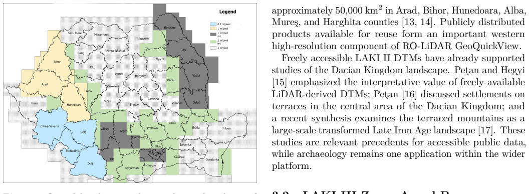
- The 0.5 m LAKI III Zone A coverage for Caras-Severin, Gorj, Mehedinti, and Dolj counties is currently available through the platform.
- LAKI III Zone B data will be added once released and processed through the same workflow.
- LAKI II and other public altimetric sources are incorporated via the same source-aware steps.
- Users gain rapid discovery and preliminary interpretation without replacing official products or field verification.
Where Pith is reading between the lines
- The same integration approach could apply to public elevation datasets in other countries that face similar fragmentation.
- Wider browser access may increase the volume of citizen-contributed landscape documentation.
- The platform's emphasis on immediate visualization could be tested for educational use in geography curricula.
Load-bearing premise
The harmonization and quality-control workflow can accommodate data from different acquisition units and sources without introducing significant artifacts or access limitations.
What would settle it
If published hillshade visualizations display systematic artifacts traceable to source differences or if the spatial index fails to deliver rasters without additional processing, the platform's claimed accessibility benefit would not hold.
Figures
read the original abstract
Public elevation data can support landscape research, environmental interpretation, planning, education, and public engagement, but their practical reuse is often limited by fragmented delivery and specialist processing requirements. This paper presents RO-LiDAR GeoQuickView, an independent, voluntary, and non-commercial Web-GIS initiative for exploring and reusing publicly accessible elevation data in Romania. The platform integrates LiDAR-derived digital terrain models (DTMs) and complementary elevation models of different resolutions, publishes standardized hillshade visualizations for immediate browser access, supports participatory landscape documentation, and provides a spatial index for direct raster retrieval. Its most detailed currently integrated component is the 0.5 m LAKI III Zone A DTM coverage for Caras-Severin, Gorj, Mehedinti, and Dolj counties. LAKI III Zone B, comprising Suceava, Neamt, Bacau, and Vrancea counties, is the next scheduled high-resolution extension. It will be integrated after the public products become available and pass through the same harmonization and quality-control workflow. The platform also incorporates LAKI II and additional public altimetric sources through a source-aware processing workflow that accommodates different acquisition units, including one-kilometre cells and larger raster blocks. The paper documents the data architecture, harmonization steps, quality-control procedures, access modes, application range, and limitations. The platform is conceived as an accessibility layer over public data infrastructures: it supports rapid discovery and preliminary interpretation, but it does not replace official products, specialist modelling, expert review, or field verification.
Editorial analysis
A structured set of objections, weighed in public.
Referee Report
Summary. The manuscript presents RO-LiDAR GeoQuickView, a voluntary non-commercial web-GIS platform for exploring public elevation data in Romania. It integrates LiDAR-derived DTMs (primarily the 0.5 m LAKI III Zone A coverage for Caras-Severin, Gorj, Mehedinti, and Dolj counties, with LAKI III Zone B and LAKI II planned) and coarser complementary models via a source-aware harmonization and quality-control workflow. The platform publishes standardized hillshade visualizations for browser access, supports participatory landscape documentation, and provides a spatial index for direct raster retrieval. It is positioned as an accessibility layer over public infrastructures, documenting data architecture, harmonization steps, QC procedures, access modes, application range, and limitations while explicitly not replacing official products or expert analysis.
Significance. If the harmonization workflow successfully integrates multi-source, multi-resolution data without artifacts, the platform would provide a useful accessibility layer that lowers barriers for landscape research, environmental interpretation, planning, education, and public engagement in Romania. The voluntary, participatory design and focus on immediate browser-based visualization add practical value for non-specialist users. However, the absence of any reported validation metrics means the assessed significance remains prospective rather than demonstrated.
major comments (2)
- [harmonization steps, quality-control procedures] The manuscript asserts that the source-aware harmonization and quality-control workflow accommodates data from different acquisition units (including 0.5 m LAKI III, LAKI II, and 1 km rasters) 'without introducing significant artifacts or access limitations,' yet reports no quantitative metrics such as seam RMSE, edge-discontinuity counts, or resolution-transition errors, nor any example test cases. This validation gap is load-bearing for the central claim of successful multi-source integration and platform utility (see abstract and the sections documenting harmonization steps and quality-control procedures).
- [data architecture, access modes] The abstract and architecture description state that the platform 'supports rapid discovery and preliminary interpretation' through standardized visualizations and direct raster access, but provide no implementation details, error metrics, or verification of the harmonization steps. This leaves the core description plausible yet untested, directly affecting the strength of the utility claim.
Simulated Author's Rebuttal
We thank the referee for the constructive comments, which correctly identify a gap in quantitative support for the harmonization claims. We address each major comment below, indicating revisions where appropriate. The manuscript describes a voluntary accessibility platform rather than a validated data-integration study, which informs our responses.
read point-by-point responses
-
Referee: [harmonization steps, quality-control procedures] The manuscript asserts that the source-aware harmonization and quality-control workflow accommodates data from different acquisition units (including 0.5 m LAKI III, LAKI II, and 1 km rasters) 'without introducing significant artifacts or access limitations,' yet reports no quantitative metrics such as seam RMSE, edge-discontinuity counts, or resolution-transition errors, nor any example test cases. This validation gap is load-bearing for the central claim of successful multi-source integration and platform utility (see abstract and the sections documenting harmonization steps and quality-control procedures).
Authors: We agree that the manuscript does not provide quantitative metrics to substantiate the claim of integration without significant artifacts. The harmonization workflow is documented using standard source-aware GIS procedures and visual QC, but no RMSE or discontinuity metrics were computed. We will revise the abstract and relevant sections to remove the unqualified assertion and instead state that the workflow is intended to minimize artifacts, with explicit advice that users should verify against original sources for any application requiring precision. This change will be made in the next version. revision: yes
-
Referee: [data architecture, access modes] The abstract and architecture description state that the platform 'supports rapid discovery and preliminary interpretation' through standardized visualizations and direct raster access, but provide no implementation details, error metrics, or verification of the harmonization steps. This leaves the core description plausible yet untested, directly affecting the strength of the utility claim.
Authors: The manuscript focuses on the platform's conceptual architecture, access modes, and documented workflow rather than on implementation benchmarks or error verification. We will add limited additional detail on the specific open-source tools and processing sequence used for harmonization to improve transparency, but we will not introduce new error metrics or test cases, as these fall outside the scope of describing an accessibility layer over existing public data. The utility claim will be qualified accordingly. revision: partial
Circularity Check
No circularity: purely descriptive platform documentation with no derivations or predictions
full rationale
The manuscript is an engineering description of a web platform that integrates existing public elevation datasets. It documents architecture, harmonization steps, QC procedures, and access modes but contains no equations, fitted parameters, predictions, or load-bearing self-citations. The harmonization workflow is presented as a procedural account rather than a derived result; no claim reduces to a self-definition or fitted input renamed as prediction. The paper explicitly positions itself as an accessibility layer, not a scientific derivation, so no circular steps exist.
Axiom & Free-Parameter Ledger
Reference graph
Works this paper leans on
-
[1]
Wehr, A. and Lohr, U. (1999). Airborne laser scanning—an introduction and overview.ISPRS Journal of Photogramme- try and Remote Sensing, 54(2–3):68–82. doi:10.1016/S0924- 2716(99)00011-8
-
[2]
Sithole, G. and Vosselman, G. (2004). Experimental comparison of filter algorithms for bare-Earth extraction from airborne laser scanning point clouds.ISPRS Jour- nal of Photogrammetry and Remote Sensing, 59(1–2):85–101. doi:10.1016/j.isprsjprs.2004.05.004
-
[3]
Kokalj, Ž. and Hesse, R. (2017).Airborne Laser Scanning Raster Data Visualization: A Guide to Good Practice. Založba ZRC, Ljubljana. doi:10.3986/9789612549848
-
[4]
Zakšek, K., Oštir, K., and Kokalj, Ž. (2011). Sky-view factor as a relief visualization technique.Remote Sensing, 3(2):398–415. doi:10.3390/rs3020398
-
[5]
Jaboyedoff, M., Oppikofer, T., Abellán, A., Derron, M.-H., Loye, A., Metzger, R., and Pedrazzini, A. (2012). Use of LiDAR in landslide investigations: a review.Natural Hazards, 61:5–28. doi:10.1007/s11069-010-9634-2
-
[6]
Hollaus, M., Wagner, W., and Kraus, K. (2005). Airborne laser scanning and usefulness for hydrological models.Advances in Geosciences, 5:57–63. doi:10.5194/adgeo-5-57-2005
-
[7]
Forestry Applications of Airborne Laser Scanning: Concepts and Case Studies
Maltamo, M., Næsset, E., and Vauhkonen, J., editors (2014). Forestry Applications of Airborne Laser Scanning: Concepts and Case Studies. Springer, Dordrecht. doi:10.1007/978-94-017- 8663-8
-
[8]
Farhan, S.M., Yin, J., Chen, Z., and Memon, M.S. (2024). A comprehensive review of LiDAR applications in crop man- agement for precision agriculture.Sensors, 24(16):5409. doi:10.3390/s24165409
-
[9]
Official project webpage
ANCPI (2016).LAKI II – Informat,ii geografice pentru mediu, schimbări climatices,i integrare UE. Official project webpage. Available online: https://www.ancpi.ro/laki2/ . Accessed 7 June 2026
2016
-
[10]
Official project webpage
ANCPI (2026).LAKI III – Informat,ii geografice pentru mediu, schimbări climatices,i integrarea UE. Official project webpage. Available online: https://www.ancpi.ro/laki3/ . Accessed 7 June 2026
2026
-
[11]
Hegyi, A. (2024). GeoQuickView: Simplifying LiDAR-derived raster visualization for everyone.Preprints.org, Technical Note, Version 1. doi:10.20944/preprints202407.2336.v1
-
[12]
Official product documentation
Esri (2026).ArcGIS Experience Builder – Overview. Official product documentation. Available online:https://www.esri.c om/en-us/arcgis/products/arcgis-experience-builder/ove rview. Accessed 7 June 2026
2026
-
[13]
Official project webpage
ANCPI (2016).LAKI II – Obiective. Official project webpage. Available online: https://www.ancpi.ro/laki2/obiective . Accessed 7 June 2026
2016
-
[14]
Technical project description
National Centre of Cartography (2025).LAKI II – Land Admin- istration Knowledge Improvement. Technical project description. Available online: https://cartografie.ro/index.php/en/poli tica-cookies/item/247-informatii-geografice-pentru-med iu-schimbari-climatice-si-integrare-ue-laki-ii-laki-i i-land-administration-knowledge-improvement . Accessed 7 June 2026
2025
-
[15]
Pet,an, A. and Hegyi, A. (2023). Freely available LiDAR-derived digital terrain model (DTM) uncovers the heartland of the Da- cian Kingdom.Digital Applications in Archaeology and Cultural Heritage, 31:e00292. doi:10.1016/j.daach.2023.e00292
-
[16]
Pet,an, A. (2023). Settlements on terraces in the central area of the Dacian Kingdom. Some aspects revealed by airborne laser scanning.Acta Musei Porolissensis, 45:205–216
2023
-
[17]
Pet,an, A. (2026). Shaping the landscape in Late Iron Age Europe: the terraced mountains of the Dacians.Humans, 6(2):19. doi:10.3390/humans6020019
-
[18]
Gut,ă, D. (2026). Un cercetător român a creat o hartă care “vede” prin păduri. Ce secrete ale României pot fi descoperite cu tehnologia LiDAR.Adevărul, 3 June 2026. Available online: https://adevarul.ro/stiri-interne/educatie/un-cerceta tor-roman-a-creat-o-harta-care-vede-2534026.html
2026
-
[19]
Hut,anu, E., Mihu-Pintilie, A., Urzica, A., Paveluc, L.E., Stoleriu, C.C., and Grozavu, A. (2020). Using 1D HEC-RAS modeling and LiDAR data to improve flood hazard maps accuracy: a case study from Jijia floodplain (NE Romania).Water, 12(6):1624. doi:10.3390/w12061624
-
[20]
Copăcean, L., Man, E.T., Cojocariu, L.L., Popescu, C.A., Vîl- ceanu, C.-B., Beilicci, R., Creţan, A., Herbei, M.V., Cuzic, O.Ş., and Herban, S. (2025). GIS-based flood assessment using hydraulic modeling and open source data: an example of appli- cation.Applied Sciences, 15(5):2520. doi:10.3390/app15052520
-
[21]
Roman, A., Ursu, T.-M., Fărcas,, S., Lăzărescu, V.-A., and Opreanu, C.H. (2017). An integrated airborne laser scanning approach to forest management and cultural heritage issues: a case study at Porolissum, Romania.Annals of Forest Research, 60(1). doi:10.15287/afr.2016.755
-
[22]
Doneus, M., Briese, C., Fera, M., and Janner, M. (2008). Ar- chaeological prospection of forested areas using full-waveform airborne laser scanning.Journal of Archaeological Science, 35(4):882–893. doi:10.1016/j.jas.2007.06.013
-
[23]
Opreanu, C.H., Lăzărescu, V.-A., Roman, A., Ursu, T.-M., and Fărcas,, S. (2014). New light on a Roman fort based on a LiDAR survey in the forested landscape from Porolissvm.Ephemeris Napocensis, 24:71–86
2014
-
[24]
Oltean, I.A. and Hanson, W.S. (2017). Conquest strategy and political discourse: new evidence for the conquest of Dacia from LiDAR analysis at Sarmizegetusa Regia.Journal of Roman Archaeology, 30:429–446. doi:10.1017/S1047759400074195
-
[25]
and Fonte, J
Oltean, I.A. and Fonte, J. (2019). Microtopographies of Dacian upland settlement strategies and community aggregation trends in the Orăs,tie Mountains, Romania. In Cowley, D., Fernández- 6 Götz, M., Romankiewicz, T., and Wendling, H., editors,Rural Settlement: Relating Buildings, Landscape, and People in the European Iron Age, pp. 251–261. Sidestone Press, Leiden
2019
-
[26]
Oltean, I.A. and Fonte, J. (2021). GIS analysis and spatial networking patterns in upland ancient warfare: the Roman conquest of Dacia.Geosciences, 11(1):17. doi:10.3390/geosciences11010017
-
[27]
Vizireanu, I. and Mateescu, R. (2018). The potential of air- borne LiDAR for detection of new archaeological site in Ro- mania. InDiversity in Coastal Marine Sciences, pp. 617–630. doi:10.1007/978-3-319-57577-3_37
-
[28]
Geomorphometricmethodsforburialmound recognition and extraction from high-resolution LiDAR DEMs
Niculit,ă, M.(2020). Geomorphometricmethodsforburialmound recognition and extraction from high-resolution LiDAR DEMs. Sensors, 20(4):1192. doi:10.3390/s20041192
-
[29]
S,tefan, M.-M. andS,tefan, D. (2021). LiDAR views of Bronze and Iron Age hill-top sites in the south-eastern Carpathi- ans.Journal of Ancient History and Archaeology, 8(3). doi:10.14795/j.v8i3.661
-
[30]
Mihu-Pintilie, A., Bras,oveanu, C., and Stoleriu, C.C. (2022). Using UAV survey, high-density LiDAR data and automated relief analysis for habitation practices characterization during the Late Bronze Age in NE Romania.Remote Sensing, 14(10):2466. doi:10.3390/rs14102466
-
[31]
Bras,oveanu, C., Mihu-Pintilie, A., and Brunchi, R.-A. (2023). Inside Late Bronze Age settlements in NE Romania: GIS-based surface characterization of ashmound structures using airborne laser scanning and aerial photography techniques.Remote Sens- ing, 15(17):4124. doi:10.3390/rs15174124
-
[32]
Pet,an, A. (2022). Carierele de calcar din zona Măgurii Călanului în lumina datelor LiDAR / The limestone quarries in the area of Măgura Călanului in the light of LiDAR data.Istros, 28:109–211
2022
-
[33]
(2026).RO-LiDAR GeoQuickView
Hegyi, A. (2026).RO-LiDAR GeoQuickView. Public Web-GIS application. Available online:https://experience.arcgis.co m/experience/a48e1284ad9f4b4cb8bb75bd96f57d49/page/web app. Accessed 7 June 2026. 7
2026
discussion (0)
Sign in with ORCID, Apple, or X to comment. Anyone can read and Pith papers without signing in.