REVIEW 1 major objections 2 minor 53 references
LXD-SLAM: LiDAR+X Dense SLAM with $\sum_{i=0}^{5}C_5^i$ Configurable Sensor Combinations
T0 review · 1 major / 2 minor · reviewed 2026-06-29 · grok-4.3
Pith's one-line read A single Iterative Error-State Kalman Filter unifies LiDAR-centered SLAM across any of 32 sensor combinations using Gaussian process sub-meshes for dense mapping.
desk verdict LXD-SLAM offers a modular multi-sensor SLAM with one unified filter and GP sub-meshes, but the consistency claim across all 32 combos lacks visible support. read the letter →
The pith
A machine-rendered reading of the paper's core claim, the machinery that carries it, and where it could break.
The reading
What carries the argument
Unified Iterative Error-State Kalman Filter that performs point-to-mesh and reprojection error minimization on continuous multi-layered Gaussian process sub-meshes, allowing the same estimator to operate across all sensor combinations.
What would settle it
Run the system on a public dataset or real-world sequence using a sensor combination where the filter diverges or the produced mesh shows large drift compared with a specialized single-sensor method, even when all described updates are active.
Extended reading notes
Core claim
LXD-SLAM is a unified multi-sensor fusion SLAM system built around 3D LiDAR that accepts any combination of camera, IMU, wheel encoder, and GNSS inputs through a single Iterative Error-State Kalman Filter. The filter applies adaptive hierarchical prediction and minimizes point-to-mesh distances plus visual reprojection errors at each update. The environment is modeled with continuous multi-layered Gaussian process sub-meshes that support efficient ray-to-mesh depth recovery for visual features. Global consistency is maintained by an Extended Scan Context descriptor extracted from the sub-meshes and a hybrid pose graph that incorporates bidirectional PnP optimization for multi-modal loop clos
Load-bearing premise
One Iterative Error-State Kalman Filter stays mathematically consistent and numerically stable for every one of the 32 sensor combinations without needing extra per-combination tuning or degeneracy fixes.
Editorial extensions
If this is right
- Any of the 32 sensor combinations can be used without redesigning the core estimation pipeline.
- The same system produces high-fidelity globally consistent dense meshes at real-time rates.
- Loop closure remains robust across modalities through Extended Scan Context descriptors and bidirectional PnP.
- Depth recovery for visual features stays efficient via ray-to-mesh queries on the Gaussian process sub-meshes.
- Odometry accuracy matches or exceeds that of specialized single-sensor solutions on public benchmarks.
Reading between the lines
- A single codebase could support many different robot platforms by swapping only the sensor inputs rather than the estimator.
- The Gaussian process sub-mesh representation might allow incremental addition of new sensor types beyond the five described if the filter equations are extended accordingly.
- Real-time dense mesh output could reduce the need for separate mapping pipelines in applications that require both localization and surface reconstruction.
- The approach could be tested on sequences containing sensor dropouts to check whether the adaptive prediction still prevents filter divergence.
Editorial analysis
A structured set of objections, weighed in public.
Referee Report
Summary. LXD-SLAM is a multi-sensor SLAM framework centered on 3D LiDAR that supports plug-and-play integration of Camera, IMU, Wheel Encoder, and GNSS sensors for all 32 combinations. It uses a single Iterative Error-State Kalman Filter with adaptive hierarchical prediction and point-to-mesh/reprojection updates, continuous multi-layered Gaussian Process sub-meshes for mapping and ray-to-mesh depth recovery, an Extended Scan Context descriptor, and Bidirectional PnP optimization for hybrid pose-graph loop closure. The paper claims that the system matches or exceeds specialized state-of-the-art odometry methods on public datasets and real-world experiments while producing high-fidelity, globally consistent dense meshes in real time.
Significance. If the unified filter maintains mathematical consistency and numerical stability across all sensor subsets without per-combination tuning, the work would offer a meaningful advance in modular SLAM by enabling a single codebase to achieve competitive performance on diverse platforms while supporting real-time dense mapping.
major comments (1)
- [Abstract / filter description] Abstract / filter description: the central claim that one Iterative Error-State Kalman Filter remains mathematically consistent and numerically stable for every one of the 32 sensor combinations (including degenerate cases such as camera-only or IMU+wheel) rests on unshown properties; no observability analysis, covariance propagation derivation, Jacobian conditioning bounds, or degeneracy-handling logic is supplied to demonstrate that the same prediction/update equations preserve positive-definiteness and well-conditioned updates uniformly.
minor comments (2)
- The abstract states 'Error-Sate' Kalman Filter; this should be corrected to 'Error-State'.
- The abstract asserts 'extensive evaluations' and performance parity/superiority but supplies no quantitative metrics, tables, or ablation summaries; a brief indication of key error figures or datasets would improve clarity.
Simulated Author's Rebuttal
We thank the referee for the constructive feedback on the mathematical foundations of the unified filter. We address the single major comment below and will incorporate the requested analysis in the revision.
read point-by-point responses
-
Referee: [Abstract / filter description] Abstract / filter description: the central claim that one Iterative Error-State Kalman Filter remains mathematically consistent and numerically stable for every one of the 32 sensor combinations (including degenerate cases such as camera-only or IMU+wheel) rests on unshown properties; no observability analysis, covariance propagation derivation, Jacobian conditioning bounds, or degeneracy-handling logic is supplied to demonstrate that the same prediction/update equations preserve positive-definiteness and well-conditioned updates uniformly.
Authors: We agree that the current manuscript lacks an explicit observability analysis, covariance propagation derivation, Jacobian conditioning bounds, and detailed degeneracy-handling logic for all 32 combinations. This omission weakens the central claim. In the revised manuscript we will add a new subsection (Section IV-C) that (1) provides an observability analysis for representative sensor subsets including the degenerate cases of camera-only and IMU+wheel, (2) derives the key covariance propagation steps under the adaptive hierarchical prediction, (3) reports conditioning bounds on the Jacobians for the point-to-mesh and reprojection updates, and (4) describes the explicit degeneracy-handling mechanisms (adaptive covariance inflation and selective measurement gating) that preserve positive-definiteness across combinations. These additions will be supported by both theoretical arguments and numerical verification on the public datasets. revision: yes
Circularity Check
No circularity; claims rest on external evaluations without self-referential reductions
full rationale
The provided abstract and text contain no equations, derivations, or parameter fits that reduce by construction to their own inputs. The unified IESKF is asserted as mathematically consistent across combinations, but this is presented as a design choice supported by evaluations on public datasets and real-world experiments rather than any internal self-definition, fitted prediction, or self-citation chain. No load-bearing uniqueness theorems, ansatzes, or renamings appear. The derivation is therefore self-contained against external benchmarks.
Assumptions & free parameters
Cite this review
Pith. "Pith review of LXD-SLAM: LiDAR+X Dense SLAM with $\sum_{i=0}^{5}C_5^i$ Configurable Sensor Combinations." pith.science (2026). https://pith.science/paper/XQAS27B2
@misc{pith2026260627811,
  author       = {Pith},
  title        = {Pith review of: LXD-SLAM: LiDAR+X Dense SLAM with $\sum_i=0^5C_5^i$ Configurable Sensor Combinations},
  year         = {2026},
  howpublished = {\url{https://pith.science/paper/XQAS27B2}},
  note         = {Machine review of arXiv:2606.27811}
}
read the original abstract
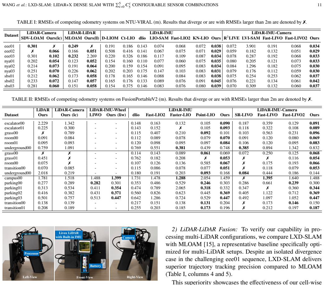
Simultaneous Localization and Mapping (SLAM) is essential for autonomous systems, yet achieving reliable, globally consistent pose estimation and dense mapping in complex environments remains challenging due to geometric degeneracy and sensor drift. While multi-sensor fusion addresses these issues, existing systems often lack the modularity to adapt to diverse platforms and rely on mathematically inconsistent fusion or suboptimal map representations. To address these limitations, we propose LXD-SLAM (LiDAR+X Dense SLAM), a highly versatile and unified multi-sensor fusion framework. Centered around 3D LiDAR, our system allows for the plug-and-play integration of LiDAR, Camera, IMU, Wheel Encoder, and GNSS, supporting up to 32 distinct sensor combinations. We employ a mathematically unified Iterative Error-Sate Kalman Filter with an adaptive hierarchical prediction strategy and an update step that minimizes point-to-mesh distances and visual reprojection errors. To support this, the environment is modeled using continuous multi-layered Gaussian Process (GP) sub-meshes, which enables efficient ray-to-mesh depth recovery for visual features. For global consistency, we introduce an Extended Scan Context (ESC) descriptor derived from the GP sub-meshes alongside a Bidirectional PnP optimization for robust multi-modal loop closure within a hybrid pose graph. Extensive evaluations on public datasets and real-world experiments demonstrate that LXD-SLAM matches or exceeds state-of-the-art specialized odometry solutions across various configurations while generating high-fidelity, globally consistent dense meshes in real-time. The relevant codes and data will be made available at https://github.com/peterWon/LXD-SLAM upon publication.
Figures


Figures from the paper (7 more)



Reference graph
Works this paper leans on
-
[1]
Present and future of SLAM in extreme environments: The DARPA SubT challenge,
K. Ebadi, L. Bernreiter, H. Biggie, G. Catt, Y. Chang, A. Chatterjee, C. E. Denniston, S.-P. Desch ˆenes, K. Harlow, S. Khattak, L. Nogueira, M. Palieri, P. Petr ´aˇcek, M. Petrl´ık, A. Reinke, V. Kr´atk´ y, S. Zhao, A.-a. Agha-mohammadi, K. Alexis, C. Heckman, K. Khosoussi, N. Kottege, B. Morrell, M. Hutter, F. Pauling, F. Pomerleau, M. Saska, S. Scherer...
2024
-
[2]
Tightly coupled 3D lidar inertial odometry and mapping,
H. Ye, Y. Chen, and M. Liu, “Tightly coupled 3D lidar inertial odometry and mapping,” inIEEE International Conference on Robotics and Automation, pp. 3144–3150, 2019
2019
-
[3]
LIO-SAM: Tightly-coupled lidar inertial odometry via smoothing and mapping,
T. Shan, B. Englot, D. Meyers, W. Wang, C. Ratti, and D. Rus, “LIO-SAM: Tightly-coupled lidar inertial odometry via smoothing and mapping,” in IEEE/RSJ International Conference on Intelligent Robots and Systems, pp. 5135–5142, 2020
2020
-
[4]
LIO-EKF: High frequency lidar-inertial odometry using extended kalman filters,
Y. Wu, T. Guadagnino, L. Wiesmann, L. Klingbeil, C. Stachniss, and H. Kuhlmann, “LIO-EKF: High frequency lidar-inertial odometry using extended kalman filters,” inIEEE International Conference on Robotics and Automation, pp. 13741–13747, 2024
2024
-
[5]
LINS: A lidar-inertial state estimator for robust and efficient navigation,
C. Qin, H. Ye, C. E. Pranata, J. Han, S. Zhang, and M. Liu, “LINS: A lidar-inertial state estimator for robust and efficient navigation,” inIEEE International Conference on Robotics and Automation, pp. 8899–8906, IEEE, 2020
2020
-
[6]
FAST-LIO2: Fast direct lidar-inertial odometry,
W. Xu, Y. Cai, D. He, J. Lin, and F. Zhang, “FAST-LIO2: Fast direct lidar-inertial odometry,”IEEE Transactions on Robotics, vol. 38, no. 4, pp. 2053–2073, 2022
-
[7]
Faster-LIO: Lightweight tightly coupled lidar-inertial odometry using parallel sparse incremental voxels,
C. Bai, T. Xiao, Y. Chen, H. Wang, F. Zhang, and X. Gao, “Faster-LIO: Lightweight tightly coupled lidar-inertial odometry using parallel sparse incremental voxels,”IEEE Robotics and Automation Letters, vol. 7, no. 2, pp. 4861–4868, 2022
2022
-
[8]
Visual-lidar odometry and mapping: low-drift, robust, and fast,
J. Zhang and S. Singh, “Visual-lidar odometry and mapping: low-drift, robust, and fast,” inIEEE International Conference on Robotics and Automation, pp. 2174–2181, 2015
2015
Show all 53 references
-
[9]
LVI-SAM: Tightly-coupled lidar-visual-inertial odometry via smoothing and mapping,
T. Shan, B. Englot, C. Ratti, and D. Rus, “LVI-SAM: Tightly-coupled lidar-visual-inertial odometry via smoothing and mapping,” inIEEE International Conference on Robotics and Automation, pp. 5692–5698, 2021
2021
-
[10]
LIC-Fusion: Lidar- inertial-camera odometry,
X. Zuo, P. Geneva, W. Lee, Y. Liu, and G. Huang, “LIC-Fusion: Lidar- inertial-camera odometry,” inIEEE/RSJ International Conference on Intelligent Robots and Systems, pp. 5848–5854, 2019
2019
-
[11]
R 2LIVE: A robust, real-time, lidar-inertial-visual tightly-coupled state estimator and mapping,
J. Lin, C. Zheng, W. Xu, and F. Zhang, “R 2LIVE: A robust, real-time, lidar-inertial-visual tightly-coupled state estimator and mapping,”IEEE Robotics and Automation Letters, vol. 6, no. 4, pp. 7469–7476, 2021
2021
-
[12]
R3LIVE: A robust, real-time, RGB-colored, LiDAR- inertial-visual tightly-coupled state estimation and mapping package,
J. Lin and F. Zhang, “R3LIVE: A robust, real-time, RGB-colored, LiDAR- inertial-visual tightly-coupled state estimation and mapping package,” in IEEE International Conference on Robotics and Automation, pp. 10672– 10678, 2022
2022
-
[13]
FAST-LIVO: Fast and tightly-coupled sparse-direct LiDAR-inertial-visual odometry,
C. Zheng, Q. Zhu, W. Xu, X. Liu, Q. Guo, and F. Zhang, “FAST-LIVO: Fast and tightly-coupled sparse-direct LiDAR-inertial-visual odometry,” inIEEE/RSJ International Conference on Intelligent Robots and Systems, pp. 4003–4009, 2022
2022
-
[14]
FAST-LIVO2: Fast, direct lidar–inertial–visual odometry,
C. Zheng, W. Xu, Z. Zou, T. Hua, C. Yuan, D. He, B. Zhou, Z. Liu, J. Lin, F. Zhu, Y. Ren, R. Wang, F. Meng, and F. Zhang, “FAST-LIVO2: Fast, direct lidar–inertial–visual odometry,”IEEE Transactions on Robotics, vol. 41, pp. 326–346, 2025
2025
-
[15]
Robust odometry and mapping for multi-lidar systems with online extrinsic calibration,
J. Jiao, H. Ye, Y. Zhu, and M. Liu, “Robust odometry and mapping for multi-lidar systems with online extrinsic calibration,”IEEE Transactions on Robotics, vol. 38, no. 1, pp. 351–371, 2022
2022
-
[16]
LIWO: LiDAR-inertial-wheel odometry,
Z. Yuan, F. Lang, T. Xu, and X. Yang, “LIWO: LiDAR-inertial-wheel odometry,” inIEEE/RSJ International Conference on Intelligent Robots and Systems, pp. 1481–1488, 2023
2023
-
[17]
VINS-Fusion: A General Optimization- Based Framework for Multi-Sensor State Estimation,
T. Qin, S. Cao, and S. Shen, “VINS-Fusion: A General Optimization- Based Framework for Multi-Sensor State Estimation,”arXiv preprint arXiv:1901.03642, 2019
1901 arXiv
-
[18]
GVINS: Tightly coupled gnss–visual–inertial fusion for smooth and consistent state estimation,
S. Cao, X. Lu, and S. Shen, “GVINS: Tightly coupled gnss–visual–inertial fusion for smooth and consistent state estimation,”IEEE Transactions on Robotics, vol. 38, no. 4, pp. 2004–2021, 2022
2004
-
[19]
LOAM: Lidar odometry and mapping in real- time,
J. Zhang and S. Singh, “LOAM: Lidar odometry and mapping in real- time,” inRobotics: Science and Systems, pp. 1–9, 2014
2014
-
[20]
LeGO-LOAM: Lightweight and ground-optimized lidar odometry and mapping on variable terrain,
T. Shan and B. Englot, “LeGO-LOAM: Lightweight and ground-optimized lidar odometry and mapping on variable terrain,” inIEEE/RSJ Interna- tional Conference on Intelligent Robots and Systems, pp. 4758–4765, 2018
2018
-
[21]
F-LOAM : Fast lidar odometry and mapping,
H. Wang, C. Wang, C.-L. Chen, and L. Xie, “F-LOAM : Fast lidar odometry and mapping,” inIEEE/RSJ International Conference on Intelligent Robots and Systems, pp. 4390–4396, 2021
2021
-
[22]
FAST-LIO: A fast, robust lidar-inertial odometry package by tightly-coupled iterated kalman filter,
W. Xu and F. Zhang, “FAST-LIO: A fast, robust lidar-inertial odometry package by tightly-coupled iterated kalman filter,”IEEE Robotics and Automation Letters, vol. 6, no. 2, pp. 3317–3324, 2021
2021
-
[23]
Point-LIO: Robust high-bandwidth light detection and ranging inertial odometry,
D. He, W. Xu, N. Chen, F. Kong, C. Yuan, and F. Zhang, “Point-LIO: Robust high-bandwidth light detection and ranging inertial odometry,” Advanced Intelligent Systems, vol. 5, no. 7, p. 2200459, 2023
2023
-
[24]
DEMO: Depth enhanced monocular odometry,
J. Zhang, M. Kaess, and S. Singh, “DEMO: Depth enhanced monocular odometry,” inIEEE/RSJ International Conference on Intelligent Robots and Systems, pp. 4975–4981, Sep 2014
2014
-
[25]
LIC-Fusion 2.0: Lidar-inertial-camera odometry with sliding-window plane-feature tracking,
X. Zuo, Y. Yang, P. Geneva, J. Lv, Y. Liu, G. Huang, and M. Pollefeys, “LIC-Fusion 2.0: Lidar-inertial-camera odometry with sliding-window plane-feature tracking,” inIEEE/RSJ International Conference on Intel- ligent Robots and Systems, pp. 5112–5119, 2020
2020
-
[26]
VINS-Mono: A robust and versatile monocular visual-inertial state estimator,
T. Qin, P. Li, and S. Shen, “VINS-Mono: A robust and versatile monocular visual-inertial state estimator,”IEEE Transactions on Robotics, vol. 34, no. 4, pp. 1004–1020, 2018
2018
-
[27]
Scalability in perception for autonomous driving: Waymo open dataset,
P. Sun, H. Kretzschmar, X. Dotiwalla, A. Chouard, V. Patnaik, P. Tsui, J. Guo, Y. Zhou, Y. Chai, B. Caine, V. Vasudevan, W. Han, J. Ngiam, H. Zhao, A. Timofeev, S. Ettinger, M. Krivokon, A. Gao, A. Joshi, Y. Zhang, J. Shlens, Z. Chen, and D. Anguelov, “Scalability in perceptio...
2020
-
[28]
nuscenes: A multimodal dataset for autonomous driving,
H. Caesar, V. Bankiti, A. H. Lang, S. Vora, V. E. Liong, Q. Xu, A. Krishnan, Y. Pan, G. Baldan, and O. Beijbom, “nuscenes: A multimodal dataset for autonomous driving,” inIEEE/CVF Conference on Computer Vision and Pattern Recognition, pp. 11618–11628, 2020
2020
-
[29]
KITTI-360: A novel dataset and bench- marks for urban scene understanding in 2D and 3D,
Y. Liao, J. Xie, and A. Geiger, “ KITTI-360: A novel dataset and bench- marks for urban scene understanding in 2D and 3D,”IEEE Transactions on Pattern Analysis and Machine Intelligence, vol. 45, pp. 3292–3310, Mar. 2023
2023
-
[30]
MLS-SLAM: Multi-level submap guided lidar SLAM,
F. Shang, W. Yu, K. Wang, L. Wang, W. Liu, W. Yang, W. Lu, G. Wang, and S. Wang, “MLS-SLAM: Multi-level submap guided lidar SLAM,” IEEE Robotics and Automation Letters, vol. 11, no. 2, pp. 1058–1065, 2026
2026
-
[31]
MLIOM-AB: Multi-lidar-inertial-odometry and mapping for autonomous buses,
T. Song, Y. Zheng, S. He, Z. Xiong, P. Wang, and X. Wu, “MLIOM-AB: Multi-lidar-inertial-odometry and mapping for autonomous buses,”IEEE Sensors Journal, vol. 24, no. 17, pp. 28036–28048, 2024
2024
-
[32]
Multi-LIO: A lightweight multiple lidar-inertial odometry system,
Q. Chen, G. Li, X. Xue, and J. Pu, “Multi-LIO: A lightweight multiple lidar-inertial odometry system,” inIEEE International Conference on Robotics and Automation, pp. 13748–13754, 2024. WANGet al.: LXD-SLAM: LIDAR+X DENSE SLAM WITH Í5 𝑖=0 𝐶𝑖 5 CONFIGURABLE SENSOR COMBINATIONS 17
2024
-
[33]
VINS on wheels,
K. J. Wu, C. X. Guo, G. Georgiou, and S. I. Roumeliotis, “VINS on wheels,” inIEEE International Conference on Robotics and Automation, pp. 5155–5162, 2017
2017
-
[34]
Efficient surfel-based SLAM using 3D laser range data in urban environments,
J. Behley and C. Stachniss, “Efficient surfel-based SLAM using 3D laser range data in urban environments,” inRobotics: Science and Systems, 2018
2018
-
[35]
SuMa++: Efficient lidar-based semantic SLAM,
X. Chen, A. Milioto, E. Palazzolo, P. Gigu`ere, J. Behley, and C. Stachniss, “SuMa++: Efficient lidar-based semantic SLAM,” inIEEE/RSJ Interna- tional Conference on Intelligent Robots and Systems, pp. 4530–4537, 2019
2019
-
[36]
Efficient and probabilistic adaptive voxel mapping for accurate online lidar odometry,
C. Yuan, W. Xu, X. Liu, X. Hong, and F. Zhang, “Efficient and probabilistic adaptive voxel mapping for accurate online lidar odometry,” IEEE Robotics and Automation Letters, vol. 7, no. 3, pp. 8518–8525, 2022
2022
-
[37]
BALM: Bundle adjustment for lidar mapping,
Z. Liu and F. Zhang, “BALM: Bundle adjustment for lidar mapping,”IEEE Robotics and Automation Letters, vol. 6, no. 2, pp. 3184–3191, 2021
2021
-
[38]
NICE-SLAM: Neural implicit scalable encoding for SLAM,
Z. Zhu, S. Peng, V. Larsson, W. Xu, H. Bao, Z. Cui, M. R. Oswald, and M. Pollefeys, “NICE-SLAM: Neural implicit scalable encoding for SLAM,” inIEEE/CVF Conference on Computer Vision and Pattern Recognition, pp. 12776–12786, 2022
2022
-
[39]
Gaussian splatting SLAM,
H. Matsuki, R. Murai, P. H. J. Kelly, and A. J. Davison, “Gaussian splatting SLAM,” inIEEE/CVF Conference on Computer Vision and Pattern Recognition, pp. 18039–18048, 2024
2024
-
[40]
GP-SLAM+: real-time 3D lidar SLAM based on improved regionalized Gaussian process map reconstruction,
J. Ruan, B. Li, Y. Wang, and Z. Fang, “GP-SLAM+: real-time 3D lidar SLAM based on improved regionalized Gaussian process map reconstruction,” inIEEE/RSJ International Conference on Intelligent Robots and Systems, pp. 5171–5178, 2020
2020
-
[41]
SLAMesh: Real-time lidar simul- taneous localization and meshing,
J. Ruan, B. Li, Y. Wang, and Y. Sun, “SLAMesh: Real-time lidar simul- taneous localization and meshing,” inIEEE International Conference on Robotics and Automation, pp. 3546–3552, 2023
2023
-
[42]
Symbolic representation and toolkit development of iterated error-state extended kalman filters on manifolds,
D. He, W. Xu, and F. Zhang, “Symbolic representation and toolkit development of iterated error-state extended kalman filters on manifolds,” IEEE Transactions on Industrial Electronics, vol. 70, no. 12, pp. 12533– 12544, 2023
2023
-
[43]
Fast ray-tracing of rectilinear volume data using distance transforms,
M. Sramek and A. Kaufman, “Fast ray-tracing of rectilinear volume data using distance transforms,”IEEE Transactions on Visualization and Computer Graphics, vol. 6, no. 3, pp. 236–252, 2000
2000
-
[44]
Random sample consensus: A paradigm for model fitting with applications to image analysis and automated cartography,
M. A. Fischler and R. C. Bolles, “Random sample consensus: A paradigm for model fitting with applications to image analysis and automated cartography,”Communications of the ACM, vol. 24, no. 6, pp. 381–395, 1981
1981
-
[45]
NTU VIRAL: A Visual-Inertial-Ranging-Lidar Dataset, from an Aerial Vehicle Viewpoint,
T. M. Nguyen, S. Yuan, M. Cao, Y. Lyu, T. H. Nguyen, and L. Xie, “NTU VIRAL: A Visual-Inertial-Ranging-Lidar Dataset, from an Aerial Vehicle Viewpoint,”International Journal of Robotics Research, vol. 41, no. 3, pp. 270–280, 2021
2021
-
[46]
FusionPortableV2: A Unified Multi-Sensor Dataset for Generalized SLAM Across Diverse Platforms and Scalable Environments,
H. Wei, J. Jiao, X. Hu, J. Yu, X. . Xie, and M. Liu, “FusionPortableV2: A Unified Multi-Sensor Dataset for Generalized SLAM Across Diverse Platforms and Scalable Environments,”International Journal of Robotics Research, vol. 44, no. 7, pp. 1093–1116, 2025
2025
-
[47]
Are we ready for autonomous driving? the KITTI vision benchmark suite,
A. Geiger, P. Lenz, and R. Urtasun, “Are we ready for autonomous driving? the KITTI vision benchmark suite,” inIEEE/CVF Conference on Computer Vision and Pattern Recognition, pp. 3354–3361, 2012
2012
-
[48]
SDV-LOAM: Semi- direct visual–lidar odometry and mapping,
Z. Yuan, Q. Wang, K. Cheng, T. Hao, and X. Yang, “SDV-LOAM: Semi- direct visual–lidar odometry and mapping,”IEEE Transactions on Pattern Analysis and Machine Intelligence, vol. 45, no. 9, pp. 11203–11220, 2023
2023
-
[49]
D-LIOM: Tightly-coupled direct lidar-inertial odometry and mapping,
Z. Wang, L. Zhang, Y. Shen, and Y. Zhou, “D-LIOM: Tightly-coupled direct lidar-inertial odometry and mapping,”IEEE Transactions on Multimedia, vol. 25, pp. 3905–3920, 2023
2023
-
[50]
Ct-LVI: A framework toward continuous-time laser-visual-inertial odometry and mapping,
Z. Wang, L. Zhang, S. Zhao, and Y. Zhou, “Ct-LVI: A framework toward continuous-time laser-visual-inertial odometry and mapping,” IEEE Transactions on Circuits and Systems for Video Technology, vol. 34, no. 6, pp. 4378–4391, 2024
2024
-
[51]
Direct lidar-inertial odometry: Lightweight LIO with continuous-time motion correction,
K. Chen, R. Nemiroff, and B. T. Lopez, “Direct lidar-inertial odometry: Lightweight LIO with continuous-time motion correction,” inIEEE International Conference on Robotics and Automation, pp. 3983–3989, 2023
2023
-
[52]
SR-LIVO: Lidar- inertial-visual odometry and mapping with sweep reconstruction,
Z. Yuan, J. Deng, R. Ming, F. Lang, and X. Yang, “SR-LIVO: Lidar- inertial-visual odometry and mapping with sweep reconstruction,”IEEE Robotics and Automation Letters, vol. 9, no. 6, pp. 5110–5117, 2024
2024
-
[53]
Scan Context++: Structural place recogni- tion robust to rotation and lateral variations in urban environments,
G. Kim, S. Choi, and A. Kim, “Scan Context++: Structural place recogni- tion robust to rotation and lateral variations in urban environments,”IEEE Transactions on Robotics, vol. 38, no. 3, pp. 1856–1874, 2022
2022
Reviewed June 29, 2026 · model on record in the stance chip above.
Discussion (0). Continue with ORCID to comment.