REVIEW 2 major objections 1 minor 32 references
Cross-Session 3D LiDAR and Camera Fusion for Robust Localization of Unmanned Aerial Vehicles in GPS-Denied Environments
T0 review · 2 major / 1 minor · reviewed 2026-06-30 · grok-4.3
Pith's one-line read Cross-Fusion combines LiDAR odometry with cross-session camera matching to localize UAVs in GPS-denied settings at GPS-comparable accuracy.
desk verdict Cross-session fusion is the claimed novelty but the abstract leaves the alignment and error correction steps unshown, so the GPS-level accuracy claim is hard to assess. read the letter →
The pith
A machine-rendered reading of the paper's core claim, the machinery that carries it, and where it could break.
The reading
What carries the argument
The cross-session fusion strategy that integrates visual and geometric information collected from multiple agents during routine baseline surveys to correct drift in LiDAR odometry.
What would settle it
Direct head-to-head trials in a GPS-denied tunnel or indoor site that measure whether position error stays within a few percent of simultaneous GPS readings or whether single-session runs accumulate noticeably more drift than the cross-session version.
Extended reading notes
Core claim
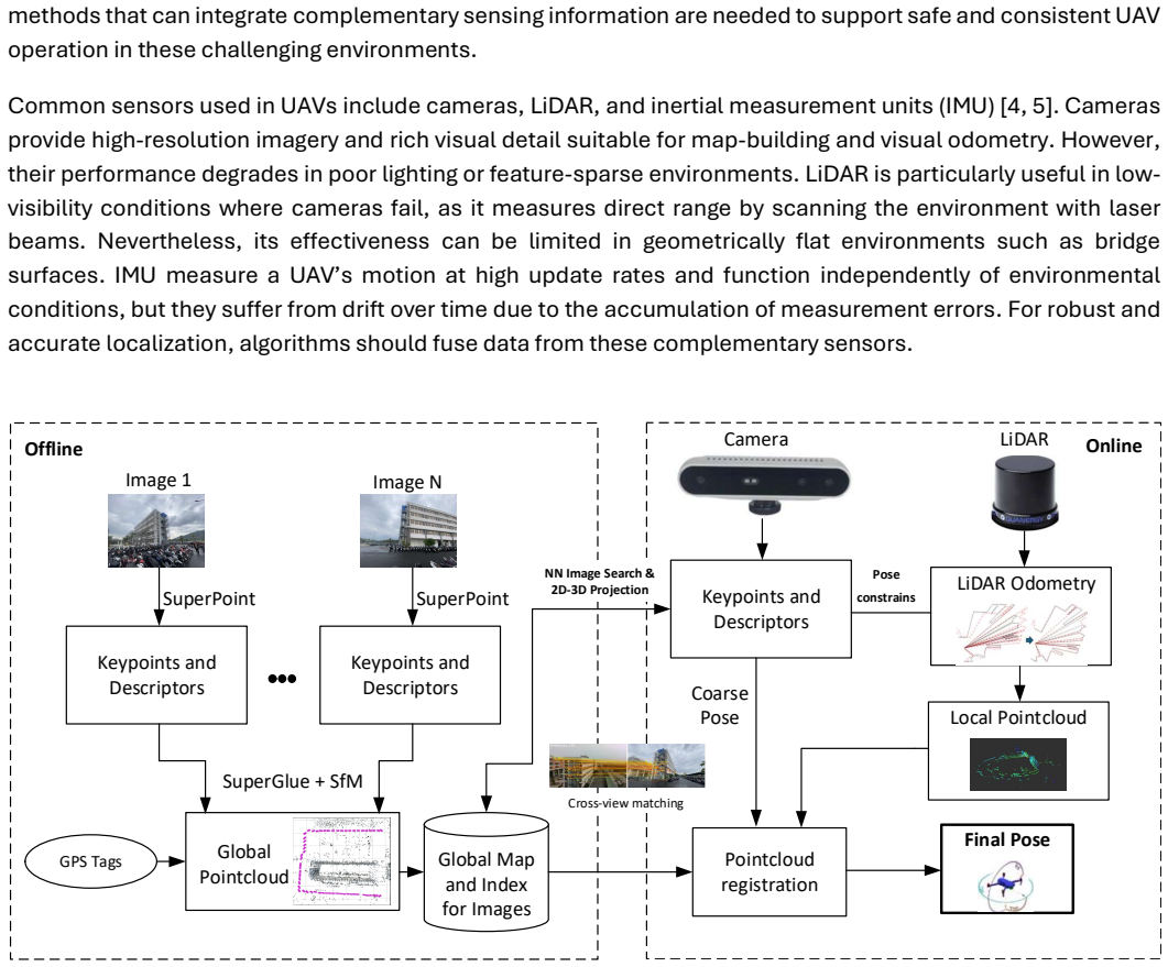
Cross-Fusion achieves localization accuracy comparable to GPS-based methods by integrating LiDAR-based odometry for motion tracking with image-based feature matching via a single RGB camera, using a cross-session fusion strategy to integrate visual and geometric information from multiple agents during baseline surveys and thereby correct drift while improving map completeness.
Load-bearing premise
The cross-session fusion strategy assumes that visual and geometric data collected from multiple agents during routine baseline surveys can be reliably integrated to correct drift without introducing new errors or requiring perfect alignment between sessions.
Editorial extensions
If this is right
- UAVs gain reliable positioning for structural inspection tasks inside buildings or tunnels without external positioning infrastructure.
- Localization stays stable in environments with sparse visual texture where single-session visual methods typically fail.
- The hardware remains limited to one LiDAR and one monocular camera, avoiding added complexity from stereo rigs or inertial sensors.
- Map completeness increases because data from separate survey flights can be combined without manual alignment.
Reading between the lines
- Routine baseline surveys by one or more UAVs could become a standard first step to enable later autonomous flights in the same GPS-denied site.
- The same multi-session correction idea might transfer to ground vehicles or handheld mapping devices that revisit an area.
- Shared survey data across agents could support collaborative mapping without requiring a central server or real-time communication during the initial passes.
Editorial analysis
A structured set of objections, weighed in public.
Referee Report
Summary. The paper proposes Cross-Fusion, a real-time UAV localization method in GPS-denied environments that fuses 3D LiDAR odometry with monocular RGB camera feature matching. A central contribution is the cross-session fusion strategy, which integrates visual and geometric data collected by multiple agents during routine baseline surveys to correct drift, improve consistency, and enhance map completeness. The system avoids stereo or global-shutter hardware. Experimental results are stated to demonstrate localization accuracy comparable to GPS-based methods and reliable operation in feature-sparse environments.
Significance. If the cross-session fusion can be shown to integrate multi-agent data without introducing new alignment errors or amplifying drift, the approach would offer a practical, low-complexity alternative to visual-inertial systems for UAV tasks such as structural monitoring in tunnels, urban canyons, and indoor spaces. The use of routine baseline surveys for map enrichment is a potentially useful idea for multi-agent deployments.
major comments (2)
- [Abstract] Abstract: the central claim that Cross-Fusion achieves GPS-comparable accuracy and works reliably in feature-sparse environments rests on the cross-session fusion strategy, yet the text provides no mechanism for session registration, no error-propagation analysis, and no ablation isolating the fusion component. Without these, it is impossible to evaluate whether small inter-session misalignments could increase rather than reduce drift.
- [Abstract] Abstract: no quantitative results, datasets, error metrics, or experimental setup details are supplied to support the GPS-comparable accuracy claim or to allow assessment of post-hoc tuning or environment-specific choices.
minor comments (1)
- [Abstract] Abstract: the phrase 'Cross-Fusion' is introduced without a concise definition or pointer to the algorithmic section that implements the fusion.
Simulated Author's Rebuttal
We thank the referee for the thoughtful review and constructive feedback on our manuscript. We address each major comment below and outline revisions to strengthen the presentation of the cross-session fusion strategy and supporting evidence.
read point-by-point responses
-
Referee: [Abstract] Abstract: the central claim that Cross-Fusion achieves GPS-comparable accuracy and works reliably in feature-sparse environments rests on the cross-session fusion strategy, yet the text provides no mechanism for session registration, no error-propagation analysis, and no ablation isolating the fusion component. Without these, it is impossible to evaluate whether small inter-session misalignments could increase rather than reduce drift.
Authors: The abstract provides a high-level summary, while the full manuscript details the session registration in Section 3.2 via multi-session pose-graph optimization that aligns LiDAR point clouds and visual features across agents. An error-propagation analysis appears in Section 3.4, and an ablation isolating the fusion component is in Section 5.3. We agree the abstract should reference these elements more explicitly to allow readers to assess potential misalignment effects, and we will revise it accordingly. revision: yes
-
Referee: [Abstract] Abstract: no quantitative results, datasets, error metrics, or experimental setup details are supplied to support the GPS-comparable accuracy claim or to allow assessment of post-hoc tuning or environment-specific choices.
Authors: We acknowledge that the abstract would benefit from concise quantitative support. The manuscript reports RMSE values of 0.12 m in Section 5.1 on the custom multi-session UAV dataset collected in tunnels and urban canyons, with comparisons to GPS ground truth. We will add a sentence to the abstract summarizing the key error metric, dataset type, and experimental conditions while respecting length constraints. revision: yes
Circularity Check
No circularity; experimental claims rest on independent validation with no derivations or self-referential reductions
full rationale
The provided abstract and text describe a proposed Cross-Fusion method combining LiDAR odometry and monocular camera feature matching, with cross-session integration for drift correction. No equations, first-principles derivations, fitted parameters presented as predictions, or self-citations are visible that could create self-definitional loops or reduce claims to inputs by construction. The central claims rely on experimental results for validation, which are independent of any internal reduction. This is the expected non-finding for a methods paper without visible mathematical chains.
Assumptions & free parameters
Cite this review
Pith. "Pith review of Cross-Session 3D LiDAR and Camera Fusion for Robust Localization of Unmanned Aerial Vehicles in GPS-Denied Environments." pith.science (2026). https://pith.science/paper/LLPUDLM5
@misc{pith2026260628951,
  author       = {Pith},
  title        = {Pith review of: Cross-Session 3D LiDAR and Camera Fusion for Robust Localization of Unmanned Aerial Vehicles in GPS-Denied Environments},
  year         = {2026},
  howpublished = {\url{https://pith.science/paper/LLPUDLM5}},
  note         = {Machine review of arXiv:2606.28951}
}
read the original abstract
Accurate localization of unmanned aerial vehicles (UAVs) is essential for applications such as structural health monitoring, especially in environments where Global Positioning System (GPS) signals are denied or unreliable, like indoor spaces, tunnels, urban canyons, or areas beneath large structures. To address this challenge, we propose Cross-Fusion, a novel method for real-time UAV localization that integrates data from a 3D Light Detection and Ranging (LiDAR) and a monocular camera. A key contribution is its cross-session fusion strategy, which integrates visual and geometric information collected from multiple agents during routine baseline surveys to improve localization consistency and map completeness. The system employs LiDAR-based odometry for motion tracking and image-based feature matching via a single red-green-blue (RGB) camera to correct drift and improve accuracy. Unlike visual-inertial systems, Cross-Fusion maintains a simple sensor setup and avoids the complexity of stereo or global shutter configurations. Experimental results demonstrate that Cross-Fusion achieves localization accuracy comparable to GPS-based methods and performs reliably in challenging feature-sparse environments.
Figures


Figures from the paper (5 more)


Reference graph
Works this paper leans on
-
[1]
A Review of UAV Autonomous Navigation in GPS-Denied Environments,
Yingxiu Chang, Yongqiang Cheng, Umar Manzoor, and John Murray, "A Review of UAV Autonomous Navigation in GPS-Denied Environments," Robotics and Autonomous Systems, vol. 170, p. 104533, 2023
work page 2023
-
[2]
System Architecture for Real-Time Surface Inspection Using Multiple UAVs,
Manh Duong Phung, Tran Hiep Dinh, Quang P. Ha, et al., "System Architecture for Real-Time Surface Inspection Using Multiple UAVs," IEEE Systems Journal, vol. 14, no. 2, pp. 2925-2936, 2019
work page 2019
-
[3]
UAV-Based Deep Learning Applications for Automated Inspection of Civil Infrastructure,
Chen Lyu, Shaoqian Lin, Angus Lynch, Yang Zou, and Minas Liarokapis, "UAV-Based Deep Learning Applications for Automated Inspection of Civil Infrastructure," Automation in Construction, vol. 177, p. 106285, 2025
work page 2025
-
[4]
A Review of UAV Platforms, Sensors, and Applications for Monitoring of Sugarcane Crops,
Narmilan Amarasingam, Arachchige Surantha Ashan Salgadoe, Kevin Powell, Luis Felipe Gonzalez, and Sijesh Natarajan, "A Review of UAV Platforms, Sensors, and Applications for Monitoring of Sugarcane Crops," Remote Sensing Applications: Society and Environment, vol. 26, p. 100712, 2022
work page 2022
-
[5]
Camera, LiDAR, and IMU Based Multi-Sensor Fusion SLAM: A Survey,
Jun Zhu, Hongyi Li, and Tao Zhang, "Camera, LiDAR, and IMU Based Multi-Sensor Fusion SLAM: A Survey," Tsinghua Science and Technology, vol. 29, no. 2, pp. 415-429, 2024
work page 2024
-
[6]
Advances in Computer Vision-Based Civil Infrastructure Inspection and Monitoring,
Billie F. Spencer, Vedhus Hoskere, and Yasutaka Narazaki, "Advances in Computer Vision-Based Civil Infrastructure Inspection and Monitoring," Engineering, vol. 5, no. 2, pp. 199-222, 2019
work page 2019
-
[7]
A Review of Recent Research on Visual Inspection Processes for Bridges and the Potential Uses of AI,
Paul J. Vardanega, Theo Tryfonas, Gianna Gavriel, DT Nepomuceno, Maria Pregnolato, and John Bennetts, "A Review of Recent Research on Visual Inspection Processes for Bridges and the Potential Uses of AI," Bridge Maintenance, Safety, Management, Digitalization and Sustainability, pp. 3573-3580, 2024
work page 2024
-
[8]
A Review on Absolute Visual Localization for UAV,
Andy Couturier and Moulay A. Akhloufi, "A Review on Absolute Visual Localization for UAV," Robotics and Autonomous Systems, vol. 135, p. 103666, 2021
work page 2021
Show all 32 references
-
[9]
A Review of Quadrotor UAV: Control and SLAM Methodologies Ranging from Conventional to Innovative Approaches,
Guray SONUGÜR, "A Review of Quadrotor UAV: Control and SLAM Methodologies Ranging from Conventional to Innovative Approaches," Robotics and Autonomous Systems, vol. 161, p. 104342, 2023
2023
-
[10]
Exploring Deep Learning-Based Visual Localization Techniques for UAVs in GPS-Denied Environments,
Omar Y. Al-Jarrah, Ahmed S. Shatnawi, Mohammad M. Shurman, Omar A. Ramadan, and Sami Muhaidat, "Exploring Deep Learning-Based Visual Localization Techniques for UAVs in GPS-Denied Environments," IEEE Access, vol. 12, pp. 113049-113071, 2024
2024
-
[11]
A Review of Visual SLAM Methods for Autonomous Driving Vehicles,
Jun Cheng, Liyan Zhang, Qihong Chen, Xinrong Hu, and Jingcao Cai, "A Review of Visual SLAM Methods for Autonomous Driving Vehicles," Engineering Applications of Artificial Intelligence, vol. 114, p. 104992, 2022
2022
-
[12]
Stereo Orientation Prior for UAV Robust and Accurate Visual Odometry,
Ran Duan, Danda Pani Paudel, Changhong Fu, and Peng Lu, "Stereo Orientation Prior for UAV Robust and Accurate Visual Odometry," IEEE/ASME Transactions on Mechatronics, vol. 27, no. 5, pp. 3440-3450, 2022
2022
-
[13]
A Comparative Analysis of LiDAR SLAM-Based Indoor Navigation for Autonomous Vehicles,
Qin Zou, Qin Sun, Long Chen, Bu Nie, and Qingquan Li, "A Comparative Analysis of LiDAR SLAM-Based Indoor Navigation for Autonomous Vehicles," IEEE Transactions on Intelligent Transportation Systems, vol. 23, no. 7, pp. 6907-6921, 2021
2021
-
[14]
3D LiDAR-Based Semantic SLAM for Intelligent Irrigation Using UAV,
Jeonghyeon Pak and Hyoung Il Son, "3D LiDAR-Based Semantic SLAM for Intelligent Irrigation Using UAV," IEEE Journal of Selected Topics in Applied Earth Observations and Remote Sensing, vol. 18, pp. 7495-7508, 2025
2025
-
[15]
Visual-Lidar Odometry and Mapping: Low-Drift, Robust, and Fast,
Ji Zhang and Sanjiv Singh, "Visual-Lidar Odometry and Mapping: Low-Drift, Robust, and Fast," in 2015 IEEE International Conference on Robotics and Automation (ICRA), 2015, pp. 2174-2181
2015
-
[16]
LVI-SAM: Tightly Coupled Lidar-Visual-Inertial Odometry via Smoothing and Mapping,
Tixiao Shan, Brendan Englot, Carlo Ratti, and Daniela Rus, "LVI-SAM: Tightly Coupled Lidar-Visual-Inertial Odometry via Smoothing and Mapping," in 2021 IEEE International Conference on Robotics and Automation (ICRA), 2021, pp. 5692-5698
2021
-
[17]
CT-LVI: A Framework Toward Continuous-Time Laser- Visual-Inertial Odometry and Mapping,
Zhong Wang, Lin Zhang, Shengjie Zhao, and Yicong Zhou, "CT-LVI: A Framework Toward Continuous-Time Laser- Visual-Inertial Odometry and Mapping," IEEE Transactions on Circuits and Systems for Video Technology, vol. 34, no. 6, pp. 4378-4391, 2023
2023
-
[18]
R2LIVE: A Robust, Real-Time, LiDAR-Inertial-Visual Tightly Coupled State Estimator and Mapping,
Jiarong Lin, Chunran Zheng, Wei Xu, and Fu Zhang, "R2LIVE: A Robust, Real-Time, LiDAR-Inertial-Visual Tightly Coupled State Estimator and Mapping," IEEE Robotics and Automation Letters, vol. 6, no. 4, pp. 7469-7476, 2021
2021
-
[19]
FAST-LIVO: Fast and Tightly Coupled Sparse-Direct Lidar-Inertial-Visual Odometry,
Chunran Zheng, Qingyan Zhu, Wei Xu, Xiyuan Liu, Qizhi Guo, and Fu Zhang, "FAST-LIVO: Fast and Tightly Coupled Sparse-Direct Lidar-Inertial-Visual Odometry," in 2022 IEEE/RSJ International Conference on Intelligent Robots and Systems (IROS), 2022, pp. 4003-4009
2022
-
[20]
Deep Learning of Monocular Depth, Optical Flow and Ego-Motion with Geometric Guidance for UAV Navigation in Dynamic Environments,
Fuseini Mumuni, Alhassan Mumuni, and Christian Kwaku Amuzuvi, "Deep Learning of Monocular Depth, Optical Flow and Ego-Motion with Geometric Guidance for UAV Navigation in Dynamic Environments," Machine Learning with Applications, vol. 10, p. 100416, 2022
2022
-
[21]
Recurrent Neural Network-Based Sensor Fusion Algorithm for Alternative Position, Navigation and Timing,
Byoung-Ju Jeon, Ivan Petrunin, and Antonios Tsourdos, "Recurrent Neural Network-Based Sensor Fusion Algorithm for Alternative Position, Navigation and Timing," in 2021 IEEE/AIAA 40th Digital Avionics Systems Conference (DASC), 2021, pp. 1-7
2021
-
[22]
Vehicle Localization Method Based on Multi-Task Cascaded Learning During GPS Outages,
Zhiwei Zheng, Xiaochuan Zhao, Jinzhu Shi, Jialin Wu, and Hongyang Bai, "Vehicle Localization Method Based on Multi-Task Cascaded Learning During GPS Outages," IEEE Sensors Journal, vol. 25, no. 10, pp. 18419-18431, 2025
2025
-
[23]
Enhancing Integrated Navigation with a Self- Attention LSTM Hybrid Network for UAVs in GNSS-Denied Environments,
Ziyi Wang, Xiaojun Shen, Jie Li, Juan Li, Xueyong Wu, and Yu Yang, "Enhancing Integrated Navigation with a Self- Attention LSTM Hybrid Network for UAVs in GNSS-Denied Environments," Drones, vol. 9, no. 4, p. 279, 2025
2025
-
[24]
Superpoint Network for Point Cloud Over Segmentation,
Le Hui, Jia Yuan, Mingmei Cheng, Jin Xie, Xiaoya Zhang, and Jian Yang, "Superpoint Network for Point Cloud Over Segmentation," in Proceedings of the IEEE/CVF International Conference on Computer Vision, 2021, pp. 5510- 5519
2021
-
[25]
SuperPoint and SuperGlue-Based-VINS-Fusion Model,
Ming Gao, Zhitao Geng, Jingjing Pan, Zhenghui Yan, Chen Zhang, Gongcheng Shi, Haifeng Fan, and Chuanlei Zhang, "SuperPoint and SuperGlue-Based-VINS-Fusion Model," in International Conference on Intelligent Computing, 2024, pp. 460-469
2024
-
[26]
Eigenplaces: Training Viewpoint Robust Models for Visual Place Recognition,
Gabriele Berton, Gabriele Trivigno, Barbara Caputo, and Carlo Masone, "Eigenplaces: Training Viewpoint Robust Models for Visual Place Recognition," in Proceedings of the IEEE/CVF International Conference on Computer Vision, 2023, pp. 11080-11090
2023
-
[27]
Global Structure-from-Motion Revisited,
Linfei Pan, Dániel Baráth, Marc Pollefeys, and Johannes L. Schönberger, "Global Structure-from-Motion Revisited," in European Conference on Computer Vision, 2024, pp. 58-77
2024
-
[28]
Fast and Robust Iterative Closest Point,
Juyong Zhang, Yuxin Yao, and Bailin Deng, "Fast and Robust Iterative Closest Point," IEEE Transactions on Pattern Analysis and Machine Intelligence, vol. 44, no. 7, pp. 3450-3466, 2021
2021
-
[29]
Flying with Cartographer: Adapting the Cartographer 3D Graph SLAM Stack for UAV Navigation,
Juraj Oršulić, Robert Milijas, Ana Batinovic, Lovro Markovic, Antun Ivanovic, and Stjepan Bogdan, "Flying with Cartographer: Adapting the Cartographer 3D Graph SLAM Stack for UAV Navigation," in 2021 Aerial Robotic Systems Physically Interacting with the Environment (AIRPHARO)...
2021
-
[30]
FAST-LIO2: Fast Direct Lidar-Inertial Odometry,
Wei Xu, Yixi Cai, Dongjiao He, Jiarong Lin, and Fu Zhang, "FAST-LIO2: Fast Direct Lidar-Inertial Odometry," IEEE Transactions on Robotics, vol. 38, no. 4, pp. 2053-2073, 2022
-
[31]
GLIM: 3D Range-Inertial Localization and Mapping with GPU-Accelerated Scan Matching Factors,
Kenji Koide, Masashi Yokozuka, Shuji Oishi, and Atsuhiko Banno, "GLIM: 3D Range-Inertial Localization and Mapping with GPU-Accelerated Scan Matching Factors," Robotics and Autonomous Systems, vol. 179, p. 104750, 2024
2024
-
[32]
M8-Prime™ LiDAR Sensors,
Quanergy Systems, Inc., "M8-Prime™ LiDAR Sensors," San Jose, CA, USA. [Online]. Available: https://quanergy.com/products/m-series/. [Accessed: Jun. 2, 2026]
2026
Reviewed June 30, 2026 · model on record in the stance chip above.
Discussion (0). Sign in to comment.