REVIEW 3 major objections 4 minor 41 references
A complete pipeline from raw mmWave radar chirps through synthetic-aperture focusing produces occupancy maps that outline indoor free space well enough for A* path planning and beat common radar baselines.
Reviewed by Pith at T0; open to challenge. T0 means a machine referee read the full paper against a public rubric. the ladder, T0–T4 →
T0 review · grok-4.5
2026-07-14 13:48 UTC pith:7ZPRPUKK
load-bearing objection Solid end-to-end SAR-to-occupancy pipeline from raw cascaded mmWave IF, with open data; gains real under oracle poses but untested under realistic odometry noise. the 3 major comments →
Millimeter Wave Radar: From Synthetic Aperture to Probabilistic Mapping
The pith
A machine-rendered reading of the paper's core claim, the machinery that carries it, and where it could break.
Core claim
When every raw FMCW sample is phase-corrected and summed by the back-projection formula, the resulting complex map can be turned into a bounded occupancy probability by a Rayleigh CDF followed by transmittance-weighted log-odds updates; the maps so obtained have lower Chamfer distance and higher F-score than CFAR or range-azimuth baselines and support higher radar-to-LiDAR path-planning success rates across ten indoor corridors and open spaces.
What carries the argument
The back-projection sum that coherently integrates every intermediate-frequency sample into a complex grid M (Eq. 11), followed by the Rayleigh-normalized amplitude R and the transmittance-modulated log-odds update of the occupancy map L (Eqs. 12–17).
Load-bearing premise
Every transmit and receive antenna pose must be known accurately enough that the phase-correction term stays coherent; any unmodeled drift or timing error defocuses the synthetic-aperture image and collapses the probability model.
What would settle it
Re-run the identical ten sequences with deliberately injected pose noise of a few centimeters or a few degrees and measure whether Chamfer distance and A* success rates fall below the CFAR and range-azimuth baselines.
If this is right
- Indoor robots can build navigation-grade occupancy maps from commercial cascade mmWave radars without LiDAR supervision or learned denoisers.
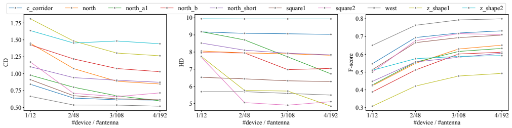
- Only three of the four cascade devices (108 virtual antenna pairs) are needed to reach the performance plateau, cutting computation and array size.
- The same Rayleigh-plus-transmittance pipeline can be applied to any FMCW radar whose raw IF samples and poses are available, independent of manufacturer.
- Downstream planners can treat the resulting free-space probability as a drop-in replacement for LiDAR occupancy maps in smoke-filled environments.
Where Pith is reading between the lines
- Because the method never trains on LiDAR, it should transfer to outdoor or multi-floor scenes once accurate poses are supplied, offering a non-learning alternative to recent neural radar mappers.
- Tightening the timing synchronization between chirps and odometry would directly raise the upper bound on map fidelity, suggesting a hardware rather than algorithmic next step.
- The 30-degree delayed field-of-view used for occupancy updates is a pragmatic focus mask; replacing it with a learned or adaptive focus metric could recover more of the full aperture without introducing unfocused free-space holes.
Editorial analysis
A structured set of objections, weighed in public.
Referee Report
Summary. The paper presents a complete pipeline that converts raw FMCW intermediate-frequency signals from cascaded mmWave radars into 2-D probabilistic occupancy maps. It first forms a complex-valued SAR image via back-projection (Eq. 11), converts amplitudes to occupancy probabilities with a Rayleigh CDF (Eq. 12), then performs ray-casting and log-odds updates (Eqs. 13–17) that respect transmittance and multi-path. The method is evaluated on ten indoor sequences against CFAR point-cloud and Range-Azimuth heatmap baselines using Chamfer/Hausdorff/F-score metrics (Table III) and A* path-planning success rates (Table IV, RoL/LoR). Ablations examine the Rayleigh scale σ_a and the number of antenna devices; an open-source cascaded-radar dataset and GPU pipeline are released.
Significance. If the reported gains hold under realistic conditions, the work supplies a practical, non-learning route from automotive-grade radar to occupancy maps usable for planning in smoke/fog, where LiDAR and cameras fail. The open dataset, GPU-accelerated code, systematic comparison of three signal-processing routes, and explicit downstream planning metric are concrete contributions that lower the barrier for subsequent radar-mapping research. The antenna-count ablation further gives useful engineering guidance on the diminishing returns of denser arrays.
major comments (3)
- [§III, Eq. (11); §IV-B1] §III and §IV-B1 state that all Tx/Rx antenna poses are known a priori and are obtained by interpolating FAST-LIO or openVINS trajectories. Every term of the coherent sum in Eq. 11 multiplies the measured sample by the phase factor exp(-j 4π f d / c). At 77 GHz a few millimetres of pose error rotates the phasor enough to destroy constructive addition at true scatterers and to inflate residual amplitudes that later feed the Rayleigh CDF (Eq. 12). No experiment injects centimetre-level drift typical of radar-only or radar-inertial odometry; consequently the quantitative superiority shown in Tables III–IV is demonstrated only under an oracle-localisation regime that the method itself does not provide. A controlled pose-noise study (or at least a discussion of the coherence length) is required before the claimed advantage over non-coherent baselines can be regarded as established for real rob
- [Abstract; §I; §IV-A] The abstract and introduction motivate the work by the failure of optical sensors in smoke and fog, yet every sequence (Fig. 5, Tables III–IV) is collected in clear indoor corridors and open workspaces. Without at least one controlled adverse-condition trial, it remains unproven that the SAR-plus-Rayleigh pipeline retains its reported edge precisely when the claimed robustness is most needed.
- [§III-C] The two-frame delay and the restriction of occupancy updates to a 30° forward FOV (§III-C) are introduced as ad-hoc safeguards against unfocused SAR regions. No sensitivity analysis is supplied; if these heuristics are removed or altered, the free-space versus unknown-space distinction (and therefore the planning success rates of Table IV) may change substantially. A short ablation or theoretical justification is needed to show that the reported gains are not artefacts of these choices.
minor comments (4)
- [Tables III–IV] Tables III and IV report point estimates without error bars or statistical tests across the ten sequences; a simple paired Wilcoxon or bootstrap interval would strengthen the claim of consistent superiority.
- [Fig. 4; Table II] Figure 4 shows the F-score peak at σ_a ≈ 0.15, yet the same value is used for all sequences without reporting per-sequence variation; a brief note on transferability would help readers re-calibrate for new sensors.
- [Eqs. (12)–(17)] The notation for the complex map M(q) and the normalised amplitude |M|/M_n is introduced cleanly, but the subsequent conversion to log-odds L(n) re-uses the symbol R for both the Rayleigh probability and the ray index; a distinct symbol would avoid momentary confusion.
- [§IV-E] In the path-planning protocol the maps are inflated by a fixed 20 cm; stating the robot’s actual footprint or showing a sensitivity plot would make the RoL/LoR numbers easier to interpret.
Circularity Check
No load-bearing circularity; empirical pipeline validated on independent LiDAR maps, with only minor hyperparameter selection of Rayleigh scale on the reported F-score curves.
specific steps
-
fitted input called prediction
[§IV-C Parameter Details / Fig. 4]
"We perform a parameter search over σ_a and evaluate the F-score against the ground-truth occupancy map across multiple sequences, as shown in Figure 4. The best average performance is achieved at σ_a ≈0.15."
σ_a is chosen by maximizing the identical F-score metric later tabulated for the proposed method on the same ten sequences. Absolute F-scores for the proposed pipeline are therefore mildly optimized rather than purely held-out; the effect is limited because the value is fixed once, shared with the RA baseline that uses the same Rayleigh model, and does not alter the qualitative ranking or planning results.
full rationale
The paper presents an engineering pipeline (FMCW IF signals to back-projection SAR via Eq. 11, Rayleigh CDF normalization Eq. 12, transmittance-weighted log-odds occupancy Eqs. 13–17) and evaluates it empirically against CFAR and Range-Azimuth baselines on ten indoor sequences using external LiDAR occupancy grids (Chamfer/Hausdorff/F-score in Table III) plus cross-validated A* planning success (RoL/LoR in Table IV). Poses are supplied by independent FAST-LIO/openVINS odometry; no equation equates the claimed map superiority to an input by construction. The sole minor issue is selection of the Rayleigh scale σ_a by grid search that maximizes average F-score on the same evaluation sequences (Fig. 4, §IV-C); the chosen value is then frozen and applied uniformly, and the same Rayleigh model is also used for the RA baseline, so the ranking versus baselines is not forced. No self-definitional loops, uniqueness theorems imported from the authors, ansatz smuggling, or renaming of known results appear. The work is self-contained against external benchmarks and does not claim first-principles predictions that reduce to fitted inputs.
Axiom & Free-Parameter Ledger
free parameters (3)
- σ_a (Rayleigh scale) =
0.15
- p_hit / p_miss occupancy clamps =
0.7 / 0.2
- l_max / l_min log-odds clamps =
3.5 / −2.0
axioms (4)
- domain assumption Antenna poses (and therefore two-way distances d) are known accurately enough for coherent phase correction in the SAR sum.
- domain assumption Normalized SAR amplitude follows a Rayleigh distribution whose scale equals the sensor thermal noise floor.
- standard math Standard log-odds occupancy recursion (Eqs. 14–16) correctly fuses successive independent sensor readings.
- ad hoc to paper A two-frame delay and a 30° forward FOV suffice to keep only focused SAR regions in the occupancy update.
read the original abstract
Robust probabilistic mapping is essential for autonomous robotic systems operating in challenging environments. While traditional sensors fail in adverse conditions such as smoke and fog, millimeter wave (mmWave) radar sensors offer reliable sensing in such conditions. However, creating accurate probabilistic maps from radar data presents significant challenges due to the inherently sparse and noisy characteristics of radio wave measurements and signal processing steps. In an attempt to address these issues, we establish a complete pipeline from raw radar signals to probabilistic occupancy maps, incorporating Synthetic Aperture Radar processing followed by a probabilistic modeling step. We conduct extensive validation across indoor environments, comparing our approach against different signal processing and probabilistic modeling approaches. We also evaluate mapping quality through downstream path planning performance analysis. Furthermore, we investigate the impact of key parameters and antenna array configuration on mapping performance. The experimental results demonstrate both the effectiveness and limitations of SAR-based probabilistic mapping for real-world robotic deployment. To facilitate future research and broader adoption, we contribute an open-source cascaded mmWave radar dataset with an accompanying GPU-accelerated signal processing pipeline available at https://github.com/rpl-cmu/rpm.
Figures


Reference graph
Works this paper leans on
-
[1]
OctoMap: An efficient probabilistic 3D mapping framework based on octrees,
A. Hornung, K. M. Wurm, M. Bennewitz, C. Stachniss, and W. Bur- gard, “OctoMap: An efficient probabilistic 3D mapping framework based on octrees,”Autonomous Robots, 2013, software available at https://octomap.github.io
2013
-
[2]
RODNet: Radar object detection using cross-modal supervision,
Y . Wang, Z. Jiang, X. Gao, J.-N. Hwang, G. Xing, and H. Liu, “RODNet: Radar object detection using cross-modal supervision,” in Proc. IEEE/CVF Winter Conference on Applications of Computer Vision (WACV), Waikoloa, USA, Jan. 2021, pp. 504–513
2021
-
[3]
ROD2021 challenge: A summary for radar object detection challenge for autonomous driving applications,
Y . Wang, J.-N. Hwang, G. Wang, H. Liu, K.-J. Kim, H.-M. Hsu, J. Cai, H. Zhang, Z. Jiang, and R. Gu, “ROD2021 challenge: A summary for radar object detection challenge for autonomous driving applications,” inProc. ACM Intl. Conf. on Multimedia Retrieval (ICMR), Taipei, TW, Nov. 2021, pp. 553–559
2021
-
[4]
Vision meets mmWave radar: 3d object perception benchmark for autonomous driving,
Y . Wang, J.-H. Cheng, J.-T. Huang, S.-Y . Kuan, Q. Fu, C. Ni, S. Hao, G. Wang, G. Xing, H. Liu,et al., “Vision meets mmWave radar: 3d object perception benchmark for autonomous driving,” in2024 IEEE Intelligent V ehicles Symposium (IV), 2024, pp. 2769–2775
2024
-
[5]
Cross-modal contrastive learning of representations for navigation using lightweight, low-cost millimeter wave radar for adverse environmental conditions,
J.-T. Huang, C.-L. Lu, P.-K. Chang, C.-I. Huang, C.-C. Hsu, P.- J. Huang, H.-C. Wang,et al., “Cross-modal contrastive learning of representations for navigation using lightweight, low-cost millimeter wave radar for adverse environmental conditions,”IEEE Robotics and Automation Letters (RA-L), vol. 6, no. 2, pp. 3333–3340, 2021
2021
-
[6]
3D ego-motion estimation using low-cost mmWave radars via radar velocity factor for pose-graph SLAM,
Y . S. Park, Y .-S. Shin, J. Kim, and A. Kim, “3D ego-motion estimation using low-cost mmWave radars via radar velocity factor for pose-graph SLAM,”IEEE Robotics and Automation Letters (RA-L), vol. 6, no. 4, pp. 7691–7698, 2021
2021
-
[7]
x-RIO: Radar inertial odometry with multiple radar sensors and yaw aiding,
C. Doer and G. F. Trommer, “x-RIO: Radar inertial odometry with multiple radar sensors and yaw aiding,”Gyroscopy and Navigation, vol. 12, pp. 329–339, 02 2022
2022
-
[8]
ColoRadar: The direct 3d millimeter wave radar dataset,
A. Kramer, K. Harlow, C. Williams, and C. Heckman, “ColoRadar: The direct 3d millimeter wave radar dataset,”Intl. J. of Robotics Research (IJRR), vol. 41, no. 4, pp. 351–360, 2022
2022
-
[9]
milliEgo: single- chip mmWave radar aided egomotion estimation via deep sensor fusion,
C. X. Lu, M. R. U. Saputra, P. Zhao, Y . Almalioglu, P. P. De Gusmao, C. Chen, K. Sun, N. Trigoni, and A. Markham, “milliEgo: single- chip mmWave radar aided egomotion estimation via deep sensor fusion,” inProc. ACM Conf. on Embedded Networked Sensor Systems, Yokohama, JP, Nov. 2020, pp. 109–122. 1/12 2/48 3/108 4/192 #device / #antenna 0.50 0.75 1.00 1.2...
2020
-
[10]
Multi-radar inertial odometry for 3d state estimation using mmWave imaging radar,
J.-T. Huang, R. Xu, A. Hinduja, and M. Kaess, “Multi-radar inertial odometry for 3d state estimation using mmWave imaging radar,” in Proc. IEEE Intl. Conf. on Robotics and Automation (ICRA), Yoko- hama, Japan, May 2024, pp. 12 006–12 012
2024
-
[11]
Dart: Implicit doppler tomography for radar novel view synthesis,
T. Huang, J. Miller, A. Prabhakara, T. Jin, T. Laroia, Z. Kolter, and A. Rowe, “Dart: Implicit doppler tomography for radar novel view synthesis,” inProc. IEEE Conf. on Computer Vision and Pattern Recognition (CVPR), 2024, pp. 24 118–24 129
2024
-
[12]
Radar fields: Frequency-space neural scene representations for fmcw radar,
D. Borts, E. Liang, T. Broedermann, A. Ramazzina, S. Walz, E. Pal- ladin, J. Sun, D. Brueggemann, C. Sakaridis, L. Van Gool,et al., “Radar fields: Frequency-space neural scene representations for fmcw radar,” inACM SIGGRAPH 2024 Conference Papers, pp. 1–10
2024
-
[13]
Learned depth estimation of 3D imaging radar for indoor mapping,
R. Xu, W. Dong, A. Sharma, and M. Kaess, “Learned depth estimation of 3D imaging radar for indoor mapping,” inProc. IEEE/RSJ Intl. Conf. on Intelligent Robots and Systems (IROS), Kyoto, Japan, Oct. 2022
2022
-
[14]
Towards dense and accurate radar perception via efficient cross-modal diffusion model,
R. Zhang, D. Xue, Y . Wang, R. Geng, and F. Gao, “Towards dense and accurate radar perception via efficient cross-modal diffusion model,” IEEE Robotics and Automation Letters (RA-L), 2024
2024
-
[15]
Radarocc: Robust 3d occupancy prediction with 4d imaging radar,
F. Ding, X. Wen, Y . Zhu, Y . Li, and C. X. Lu, “Radarocc: Robust 3d occupancy prediction with 4d imaging radar,”Advances in Neural Information Processing Systems, vol. 37, pp. 101 589–101 617, 2024
2024
-
[16]
Rmap: Millimeter- wave radar mapping through volumetric upsampling,
A. N. Mopidevi, K. Harlow, and C. Heckman, “Rmap: Millimeter- wave radar mapping through volumetric upsampling,” inProc. IEEE/RSJ Intl. Conf. on Intelligent Robots and Systems (IROS), abudhabi, UAE, Oct. 2024, pp. 1108–1115
2024
-
[17]
High resolution point clouds from mmwave radar,
A. Prabhakara, T. Jin, A. Das, G. Bhatt, L. Kumari, E. Soltanaghai, J. Bilmes, S. Kumar, and A. Rowe, “High resolution point clouds from mmwave radar,” inProc. IEEE Intl. Conf. on Robotics and Automation (ICRA), London, UK, June 2023, pp. 4135–4142
2023
-
[18]
P.-C. Kung, S. Harisha, R. Vasudevan, A. Eid, and K. A. Skinner, “Radarsplat: Radar gaussian splatting for high-fidelity data synthesis and 3d reconstruction of autonomous driving scenes,”arXiv preprint arXiv:2506.01379, 2025
Pith/arXiv arXiv 2025
-
[19]
Towards foundational models for single- chip radar,
T. Huang, A. Prabhakara, C. Chen, J. Karhade, D. Ramanan, M. O’toole, and A. Rowe, “Towards foundational models for single- chip radar,” inProceedings of the IEEE/CVF International Conference on Computer Vision (ICCV), October 2025, pp. 24 655–24 665
2025
-
[20]
Development and demonstra- tion of mimo-sar mmwave imaging testbeds,
M. E. Yanik, D. Wang, and M. Torlak, “Development and demonstra- tion of mimo-sar mmwave imaging testbeds,”IEEE Access, vol. 8, pp. 126 019–126 038, 2020
2020
-
[21]
Probabilistic sar processing for high-resolution mapping us- ing millimeter-wave radar sensors,
T. Grebner, A. Grathwohl, P. Schoeder, V . Janoudi, and C. Wald- schmidt, “Probabilistic sar processing for high-resolution mapping us- ing millimeter-wave radar sensors,”IEEE Transactions on Aerospace and Electronic Systems, vol. 59, no. 5, pp. 4800–4814, 2023
2023
-
[22]
Radar- based mapping of the environment: Occupancy grid-map versus sar,
T. Grebner, P. Schoeder, V . Janoudi, and C. Waldschmidt, “Radar- based mapping of the environment: Occupancy grid-map versus sar,” IEEE Microwave and Wireless Components Letters, vol. 32, no. 3, pp. 253–256, 2022
2022
-
[23]
Indoor synthetic aperture radar measurements of point-like targets using a wheeled mo- bile robot,
Y . E. Ritterbusch, J. Fink, and C. Waldschmidt, “Indoor synthetic aperture radar measurements of point-like targets using a wheeled mo- bile robot,” inEUSAR 2024; 15th European Conference on Synthetic Aperture Radar. VDE, 2024, pp. 595–600
2024
-
[24]
Rio-sar: Synthetic aperture radar imaging of indoor scenes based on radar-inertial odometry using a mobile robot,
——, “Rio-sar: Synthetic aperture radar imaging of indoor scenes based on radar-inertial odometry using a mobile robot,”IEEE Trans- actions on Radar Systems, 2024
2024
-
[25]
Simultaneous localization and mapping for indoor mobile robots using synthetic aperture radar images,
——, “Simultaneous localization and mapping for indoor mobile robots using synthetic aperture radar images,”IEEE Journal of Indoor and Seamless Positioning and Navigation, 2024
2024
-
[26]
Automotive radar gridmap representa- tions,
K. Werber, M. Rapp, J. Klappstein, M. Hahn, J. Dickmann, K. Diet- mayer, and C. Waldschmidt, “Automotive radar gridmap representa- tions,” inIEEE MTT-S International Conference on Microwaves for Intelligent Mobility (ICMIM), 2015, pp. 1–4
2015
-
[27]
3d occupancy grid mapping using statistical radar models,
J. Degerman, T. Pernstål, and K. Alenljung, “3d occupancy grid mapping using statistical radar models,” inIEEE Intelligent V ehicles Symposium (IV), 2016, pp. 902–908
2016
-
[28]
Adap- tions for automotive radar based occupancy gridmaps,
R. Prophet, H. Stark, M. Hoffmann, C. Sturm, and M. V ossiek, “Adap- tions for automotive radar based occupancy gridmaps,” inIEEE MTT- S International Conference on Microwaves for Intelligent Mobility (ICMIM), 2018, pp. 1–4
2018
-
[29]
Radar-inertial ego-velocity estimation for visually degraded environments,
A. Kramer, C. Stahoviak, A. Santamaria-Navarro, A.-A. Agha- Mohammadi, and C. Heckman, “Radar-inertial ego-velocity estimation for visually degraded environments,” inProc. IEEE Intl. Conf. on Robotics and Automation (ICRA), Paris, FR, May 2020, pp. 5739– 5746
2020
-
[30]
PreCFAR gridmaps for automotive radar,
F. Weishaupt, N. Appenrodt, J. F. Tilly, J. Dickmann, and D. Heberling, “PreCFAR gridmaps for automotive radar,” in18th European Radar Conference (EuRAD). IEEE, 2022, pp. 161–164
2022
-
[31]
Realistic sar implementation for automotive applications,
H. Iqbal, A. Löffler, M. N. Mejdoub, and F. Gruson, “Realistic sar implementation for automotive applications,” inIEEE 17th European Radar Conference (EuRAD), 2021, pp. 306–309
2021
-
[32]
See through smoke: robust indoor map- ping with low-cost mmwave radar,
C. X. Lu, S. Rosa, P. Zhao, B. Wang, C. Chen, J. A. Stankovic, N. Trigoni, and A. Markham, “See through smoke: robust indoor map- ping with low-cost mmwave radar,” inProc. of the 18th International Conference on Mobile Systems, Applications, and Services, 2020, pp. 14–27
2020
-
[33]
High-resolution image synthesis and semantic manipulation with conditional GANs,
T.-C. Wang, M.-Y . Liu, J.-Y . Zhu, A. Tao, J. Kautz, and B. Catanzaro, “High-resolution image synthesis and semantic manipulation with conditional GANs,” inProc. IEEE Conf. on Computer Vision and Pattern Recognition (CVPR), 2018, pp. 8798–8807
2018
-
[34]
Enabling visual recognition at radio frequency,
H. Lai, G. Luo, Y . Liu, and M. Zhao, “Enabling visual recognition at radio frequency,” inProceedings of the 30th Annual International Conference on Mobile Computing and Networking (MobiCom), 2024, pp. 388–403
2024
-
[35]
Synthetic-aperture radar processing using fast factorized back-projection,
L. M. Ulander, H. Hellsten, and G. Stenstrom, “Synthetic-aperture radar processing using fast factorized back-projection,”IEEE Transac- tions on Aerospace and electronic systems, vol. 39, no. 3, pp. 760–776, 2003
2003
-
[36]
J. C. Curlander and R. N. McDonough,Synthetic aperture radar. Wiley, New York, 1991, vol. 11
1991
-
[37]
Focusing of airborne synthetic aperture radar data from highly nonlinear flight tracks,
O. Frey, C. Magnard, M. Ruegg, and E. Meier, “Focusing of airborne synthetic aperture radar data from highly nonlinear flight tracks,”IEEE transactions on geoscience and remote sensing, vol. 47, no. 6, pp. 1844–1858, 2009
2009
-
[38]
Modeling sar images with a gener- alization of the rayleigh distribution,
E. E. Kuruoglu and J. Zerubia, “Modeling sar images with a gener- alization of the rayleigh distribution,”IEEE Transactions on Image Processing, vol. 13, no. 4, pp. 527–533, 2004
2004
-
[39]
Fast-lio: A fast, robust lidar-inertial odometry package by tightly-coupled iterated kalman filter,
W. Xu and F. Zhang, “Fast-lio: A fast, robust lidar-inertial odometry package by tightly-coupled iterated kalman filter,”IEEE Robotics and Automation Letters, vol. 6, no. 2, pp. 3317–3324, 2021
2021
-
[40]
OpenVINS: A research platform for visual-inertial estimation,
P. Geneva, K. Eckenhoff, W. Lee, Y . Yang, and G. Huang, “OpenVINS: A research platform for visual-inertial estimation,” inProc. IEEE Intl. Conf. on Robotics and Automation (ICRA), Paris, FR, May 2020, pp. 4666–4672
2020
-
[41]
Imaging radar using cascaded mmwave sensor reference design,
I. Texas Instruments, “Imaging radar using cascaded mmwave sensor reference design,” 2020
2020
discussion (0)
Sign in with ORCID, Apple, or X to comment. Anyone can read and Pith papers without signing in.