REVIEW 3 major objections 6 minor 47 references
GeoBridge: Decoupled Semantic Conditioning for Generative Image Geolocalization
T0 review · 3 major / 6 minor · reviewed 2026-08-16 · deepseek-v4-flash
Pith's one-line read GeoBridge improves fine-scale image geolocation by decoding frozen MLLM hidden states through role-decoupled conditioning into a frozen spherical flow-matching head.
desk verdict A transparent, useful decode-side study with a real bottleneck analysis, but the headline 'role conflict' mechanism is confounded with connector capacity in the ablations. read the letter →
The pith
A machine-rendered reading of the paper's core claim, the machinery that carries it, and where it could break.
The reading
What carries the argument
Role-decoupled conditioning is the central mechanism. Five trainable role tokens—country, region, city, latitude, longitude—are appended to the prompt before the frozen MLLM's final layer; the three contextual roles receive lightweight cross-entropy supervision from administrative labels, while the two spatial roles give coordinate-oriented information a separate place. A one-layer bidirectional transformer connector lets the five tokens exchange information, the contextual and spatial groups are averaged separately, and a linear projection maps their concatenation to a single 1024-dimensional condition vector. That projection buffer restores the single-token interface the frozen Riemannian flow-matching head was trained on, so semantic supervision shapes the hidden states without corrupting the smooth manifold geometry the head consumes. The head then integrates a learned vector field on $\mathbb{S}^2$, transporting a uniform sample to the predicted coordinate.
What would settle it
For a fixed set of IM2GPS3K images, feed the true country and city names as the semantic prefix at inference for every image, exactly as in the oracle protocol, and compare the realized 25 km accuracy; if it does not jump from the deployable 38.67 percent toward the reported 71.67 percent oracle value, the bottleneck is not the semantic condition and the paper's central explanation fails.
Extended reading notes
Core claim
The paper's central claim is that the bottleneck in MLLM-based image geolocalization has moved from reasoning to decoding: the semantic representations an MLLM builds are rich enough, but representing them as a discrete place name for a geocoding API wastes image evidence and collapses granularity. GeoBridge therefore reads five learned role tokens (country, region, city, latitude, longitude) from the hidden states of a frozen MLLM, applies light cross-entropy supervision to the three contextual roles, pools contextual and spatial groups separately, and projects them into one 1024-dimensional condition vector for a frozen Riemannian flow-matching head that generates coordinates on the sphere. On IM2GPS3K this reaches 38.67/52.89/70.37 percent at 25/200/750 km, above place-name geocoding and reasoning-augmented direct prediction at those scales. The key evidence for the bottleneck claim is the oracle condition: with ground-truth country/city text supplied, the same frozen head reaches 71.67 percent at 25 km and a median error of 11.67 km, so the frozen head is far from saturated and the deployable limit is the semantic condition.
Load-bearing premise
The whole gain rests on the assumption that a condition learned from teacher-forced, correctly spelled country and city names still works when the MLLM generates its own, often wrong or differently worded names at test time; the paper reports only 25 percent of IM2GPS3K images receive both a correct country and city, and Appendix I acknowledges sensitivity to surface form.
Editorial extensions
If this is right
- A wrong place name no longer forces a jump to the wrong city center: even when both country and city are wrong, GeoBridge's mean error on IM2GPS3K is 4263.5 km versus 4384.4 km for geocoding.
- Because the MLLM and coordinate head stay frozen, GeoBridge composes with stronger reasoning backbones; improving the semantic prefix should transfer directly, as the oracle-condition ceiling suggests.
- The ablation ordering indicates that structured role grouping and connector capacity, not token count, drive the gain, so future interface designs should focus on semantic decomposition and projection.
- On benchmarks whose ground truth is city-center-aligned, the comparison depends on how often the city is named correctly; on cross-domain IM2GPS3K only 25 percent of images get both country and city right, which is where continuous decoding wins at fine scales.
Reading between the lines
- A testable consequence of the bottleneck claim is that canonicalizing or entity-grounding generated place names before conditioning should lift deployable accuracy toward the oracle ceiling without retraining the connector, since the paper identifies surface-form drift as a source of condition degradation.
- The role conflict between categorical supervision and a manifold-valued condition is likely to recur wherever a frozen LLM semantics conditions a geometric decoder, for example in audio or motion generation; GeoBridge's contextual/spatial split is a template the paper does not test outside geolocation.
- The paper's robustness numbers suggest continuous image-grounded decoding gives a consistent edge even when the final output someone wants is a semantic label rather than a coordinate, because the decode stays anchored to visual evidence.
Signed reviews
Editorial analysis
A structured set of objections, weighed in public.
Referee Report
Summary. GeoBridge proposes a decode-side conditioning mechanism for MLLM-based image geolocalization. Instead of turning MLLM reasoning into a single place name for a geocoding API, the method reads the hidden states of five learned role tokens (country, region, city, latitude, longitude) from a frozen MLLM, passes them through a trainable connector, and uses the resulting single condition vector to drive a frozen Riemannian flow-matching head that generates coordinates on the sphere. The paper's central claim is that discrete semantic supervision of the condition causes a 'role conflict' with the smooth continuous geometry expected by the frozen head, and that this is resolved by decoupling the semantic supervision (applied to role tokens/auxiliary heads) from the final condition interface (a projected pooled vector). On IM2GPS3K, GeoBridge reports 38.67/52.89/70.37/84.42 at 25/200/750/2500 km, improving over place-name geocoding baselines at fine thresholds; on MP16-Reason-Test it is competitive. An oracle condition experiment indicates that the frozen head is far from saturated, and the paper attributes the residual deployable gap to the quality of the semantic condition rather than to the coordinate head.
Significance. If the mechanism is properly supported, the paper makes a useful contribution: it reframes MLLM geolocalization as a representation/decoding problem rather than a reasoning problem, and the idea of connecting frozen MLLMs to frozen generative decoders through a learned conditioning interface is timely and likely to be of interest beyond geolocalization. The authors deserve credit for reporting an explicitly labeled oracle upper bound, for training and evaluating on disjoint data, for including component ablations, and for transparently acknowledging that the role cross-entropy is approximately neutral in deployment and that the connector accounts for most of the realized gain. The 1-to-N condition expansion is a sensible variance-reduction estimator. However, the central conceptual claim—that role-decoupled conditioning resolves a role conflict—is not isolated by the current experimental design, and the paper's own deployable ablation suggests that the headline improvement is driven by connector capacity rather than by the role-decoupling structure.
major comments (3)
- [§5.1, Tables 4 and 8] The ablation design confounds connector capacity with role-token structure. The progression from 'Single-token, MLP' to 'Full GeoBridge (+ role CE)' changes the role-token set, the grouping, the connector module, and the auxiliary semantic losses simultaneously. The deployable data (Table 8) show that replacing the MLP connector with Q2Enc on grouped role tokens lifts @25 from 23.36 to 38.50, while adding role CE changes @25 by only +0.17 and is slightly worse at @750. Without a 'single-token, Q2Enc' condition and an 'ungrouped, Q2Enc' condition, the reader cannot determine whether role tokens and grouping contribute anything once the connector is sufficiently expressive. The text's conclusion that 'structure matters more than token count' is therefore not established; the missing conditions are needed to attribute the gain to role-decoupled structure rather than to connector capacity.
- [§3.2, §5.1 (Tables 4 and 8)] The 'role conflict' hypothesis is never directly tested. The paper claims that supervising the condition representation with discrete semantic labels 'pulls it toward class-discriminative geometry' and corrupts the continuous condition, but no experiment applies semantic cross-entropy directly to the final condition vector (or to the single token) and compares it with the proposed decoupled supervision. The oracle ablation in Table 4 adds role CE on top of grouped+Q2Enc, which changes the auxiliary heads rather than testing direct supervision of the condition interface. A direct-supervision baseline—e.g., adding country/city CE to the pooled condition c while keeping the same connector—is essential to support the central mechanism claim. Without it, the paper's narrative that decoupling is what prevents corruption is unsupported by the reported experiments.
- [§3.4, §4.2, Appendix I] The train/eval policy introduces a distribution shift that weakens the bottleneck attribution. During training the connector sees teacher-forced ground-truth semantic prefixes; at inference it sees generated prefixes, and the paper reports that only 25% of IM2GPS3K images receive both a correct country and city (Table 3 discussion). Appendix I further acknowledges sensitivity to surface form. The oracle gap in Table 2 (deployable 38.67 vs. oracle 71.67 @25) is therefore not purely a measure of semantic correctness; it also includes the representation shift between teacher-forced and generated prefixes. The claim that 'the deployable limit is the quality of the condition' conflates these two factors. The authors should quantify this shift, e.g., by measuring the distance between teacher-forced and generated role-token states or connector outputs on the same images, or by training with a mix of generated prefixes.
minor comments (6)
- [Abstract and §4.2] The abstract states that GeoBridge improves over a place-name-to-API pipeline at 'these precision-relevant scales' without noting that on MP16-Reason-Test GLOBE remains better at @25 and @200 (60.95 vs. 57.44 and 74.00 vs. 72.39). The main text discusses this trade-off clearly, but the abstract should be qualified.
- [§5.1 and Table 4] The phrase 'Connector capacity and role supervision close the gap' suggests that role supervision is part of the closing, but the subsequent paragraph and Table 8 show that role CE is approximately neutral in deployment. Please rephrase to match the evidence.
- [Appendix F, Table 5] The Euclidean flow-matching baseline uses an interpolant in R^3, and the text notes that a final projection or normalization is required to produce a valid location. Please state explicitly whether such a projection was used in the FM row of Table 5 and how it was applied.
- [§1 and §6] The claim that GeoBridge is 'orthogonal and complementary to chain-of-thought reasoning' is plausible but is not tested: no experiment combines GeoBridge with a CoT-augmented backbone. Please soften this claim or provide supporting evidence.
- [General] No error bars, standard deviations, or number of seeds are reported for the main results. Given that several improvements over strong baselines are a few points at a single threshold, variance estimates would increase confidence.
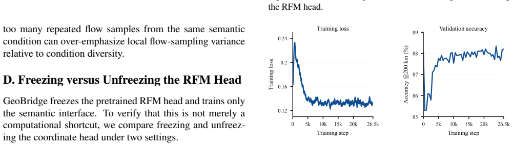
- [Appendix D] Figures 8 and 9 report training loss and validation accuracy curves but appear to lack axis labels in the provided version. Please add clear axis labels and legends.
Circularity Check
No significant circularity: GeoBridge's benchmark numbers are genuine held-out evaluations, the oracle condition is explicitly an upper-bound diagnostic, and the only self-citation (GaGA) is tangential.
full rationale
The paper's central derivation is self-contained against external benchmarks. The deployable results (38.67/52.89/70.37 on IM2GPS3K) are obtained by running the trained connector with a generated semantic prefix on a held-out test set, not by inverting a fitted parameter or by renaming an input as a prediction. The oracle condition row is explicitly labeled 'not a deployable accuracy claim' and is used only to measure the representational ceiling of the frozen RFM head, so it is a diagnostic upper bound rather than a claimed prediction. The ablations in Tables 4 and 8 compare design variants under fixed training data, backbone, and head; even though the connector and role-token structure are varied together, that is a question of experimental isolation, not circularity, and the paper transparently reports that role cross-entropy is nearly neutral in deployment. The only self-citation is GaGA in the related-work paragraph, which is descriptive and does not carry any load-bearing argument. No equation is shown to reduce to its own input, no fitted value is renamed as a prediction, and no uniqueness claim is imported from the authors' prior work. The paper's claims are therefore empirically grounded rather than circular.
Assumptions & free parameters
free parameters (5)
- lambda_country_CE =
0.05
- lambda_city_CE =
0.02
- lambda_region_CE =
0.0 (disabled)
- N_flow_expansion =
8
- K_euler_steps =
32
assumptions (4)
- domain assumption The frozen RFM spherical head (PLONK) is capable of higher precision than deployable GeoBridge attains, so the head is not the limiting factor.
- domain assumption The MLLM's hidden states after role-token injection contain sufficient geographic semantic information to condition coordinate generation.
- ad hoc to paper Teacher-forced semantic prefixes and generated semantic prefixes at inference produce hidden states in the same region of the connector's input space.
- standard math Riemannian flow matching on S^2 with uniformly sampled base points is a valid generative objective for geolocation.
invented entities (1)
-
Five role tokens (country, region, city, latitude, longitude) with contextual/spatial grouping
Cite this review
Pith. "Pith review of GeoBridge: Decoupled Semantic Conditioning for Generative Image Geolocalization." pith.science (2026). https://pith.science/paper/HZOIPQDH
@misc{pith2026260811838,
  author       = {Pith},
  title        = {Pith review of: GeoBridge: Decoupled Semantic Conditioning for Generative Image Geolocalization},
  year         = {2026},
  howpublished = {\url{https://pith.science/paper/HZOIPQDH}},
  note         = {Machine review of arXiv:2608.11838}
}
read the original abstract
Multimodal large language models (MLLMs) have advanced image geolocalization mainly by improving how they reason about geographic cues. How that reasoning isdecoded into coordinates, however, has lagged behind. Predicting a place name for a geocoding API is discrete and lossy: it ignores image evidence and collapses multi-granular semantics into a coarse lookup. We argue that the bottleneck has shifted from what a model reasons to how that reasoning is represented for a continuous, geometry-aware decoder. We present GeoBridge, a role-decoupled conditioning mechanism that connects a frozen semantic MLLM to a frozen Riemannian flow-matching head that generates coordinates on the sphere. The central obstacle is arole conflict: supervising the condition with discrete semantic labels biases its representation toward class-discriminative geometry, at odds with the smooth manifold the generative head requires. GeoBridge keeps the semantic supervision decoupled from the condition interface: a separate projection forms the continuous condition the frozen head expects, injecting geographic priors without disturbing the spherical decoder. On IM2GPS3K, GeoBridge reaches 38.67/52.89/70.37 at the 25/200/750 km thresholds, improving over a place-name-to-API pipeline and reasoning-augmented direct prediction at these precision-relevant scales. GeoBridge is a decode-side algorithmic contribution, orthogonal and complementary to chain-of-thought reasoning. Code will be made publicly available.
Figures


Figures from the paper (6 more)



Reference graph
Works this paper leans on
-
[1]
Openstreetview-5m: The many roads to global visual geolocation
Guillaume Astruc, Nicolas Dufour, Ioannis Siglidis, Con- stantin Aronssohn, Nacim Bouia, Stephanie Fu, Romain Loiseau, Van Nguyen Nguyen, Charles Raude, Elliot Vin- cent, et al. Openstreetview-5m: The many roads to global visual geolocation. InProceedings of the IEEE/CVF Con- ference on Computer Vision and Pattern Recognition, pages 21967–21977, 2024. 1, 6
work page 2024
-
[2]
Qwen2.5-vl technical report.arXiv preprint arXiv:2502.13923, 2025
Shuai Bai, Keqin Chen, Xuejing Liu, Jialin Wang, Wenbin Ge, Sibo Song, Kai Dang, Peng Wang, Shijie Wang, Jun Tang, Humen Zhong, Yuanzhi Zhu, Mingkun Yang, Zhao- hai Li, Jianqiang Wan, Pengfei Wang, Wei Ding, Zheren Fu, Yiheng Xu, Jiabo Ye, Xi Zhang, Tianbao Xie, Zesen Cheng, Hang Zhang, Zhibo Yang, Haiyang Xu, and Jun- yang Lin. Qwen2.5-vl technical repor...
arXiv 2025
-
[3]
Gaea: A geoloca- tion aware conversational model, 2025
Ron Campos, Ashmal Vayani, Parth Parag Kulkarni, Rohit Gupta, Aritra Dutta, and Mubarak Shah. Gaea: A geoloca- tion aware conversational model, 2025. 2, 5, 6
work page 2025
-
[4]
Shikra: Unleashing multimodal llm’s referential dialogue magic, 2023
Keqin Chen, Zhao Zhang, Weili Zeng, Richong Zhang, Feng Zhu, and Rui Zhao. Shikra: Unleashing multimodal llm’s referential dialogue magic, 2023. 3
work page 2023
-
[5]
Flow matching on gen- eral geometries
Ricky TQ Chen and Yaron Lipman. Flow matching on gen- eral geometries. InInternational Conference on Learning Representations, pages 47922–47945, 2024. 4, 13
work page 2024
-
[6]
Kulkarni, Vicente Vi- vanco Cepeda, and Mubarak Shah
Brandon Clark, Alec Kerrigan, Parth P. Kulkarni, Vicente Vi- vanco Cepeda, and Mubarak Shah. Where we are and what we’re looking at: Query based worldwide image geo- localization using hierarchies and scenes. InProceedings of the IEEE/CVF Conference on Computer Vision and Pattern Recognition, 2023. 2, 6
work page 2023
-
[7]
Gaga: Towards interactive global geolocation assistant, 2025
Zhiyang Dou, Zipeng Wang, Xumeng Han, Guorong Li, Zhipei Huang, and Zhenjun Han. Gaga: Towards interactive global geolocation assistant, 2025. 1, 3
work page 2025
-
[8]
Around the world in 80 timesteps: A generative approach to global visual geolocation
Nicolas Dufour, Vicky Kalogeiton, David Picard, and Loic Landrieu. Around the world in 80 timesteps: A generative approach to global visual geolocation. InProceedings of the Computer Vision and Pattern Recognition Conference, pages 23016–23026, 2025. 2, 4, 5, 6
work page 2025
Show all 47 references
-
[9]
Geotoken: Hierarchical geolocalization of images via next token prediction
Narges Ghasemi, Amir Ziashahabi, Salman Avestimehr, and Cyrus Shahabi. Geotoken: Hierarchical geolocalization of images via next token prediction. InIEEE International Con- ference on Data Mining, 2025. 3
2025
-
[10]
Pigeon: Predicting image geolocations
Lukas Haas, Michal Skreta, Silas Alberti, and Chelsea Finn. Pigeon: Predicting image geolocations. InProceedings of the IEEE/CVF Conference on Computer Vision and Pattern Recognition, pages 12893–12902, 2024. 2
2024
-
[11]
Im2gps: estimating geo- graphic information from a single image
James Hays and Alexei A Efros. Im2gps: estimating geo- graphic information from a single image. InCVPR, 2008. 1
2008
-
[12]
G3: an effective and adaptive framework for worldwide geolocalization using large multi- modality models.Advances in Neural Information Process- ing Systems, 37:53198–53221, 2024
Pengyue Jia, Yiding Liu, Xiaopeng Li, Xiangyu Zhao, Yuhao Wang, Yantong Du, Xiao Han, Xuetao Wei, Shuaiqiang Wang, and Dawei Yin. G3: an effective and adaptive framework for worldwide geolocalization using large multi- modality models.Advances in Neural Information Process- in...
2024
-
[13]
Georanker: Distance-aware ranking for worldwide image geolocalization.arXiv preprint arXiv:2505.13731, 2025
Pengyue Jia, Seongheon Park, Song Gao, Xiangyu Zhao, and Yixuan Li. Georanker: Distance-aware ranking for worldwide image geolocalization.arXiv preprint arXiv:2505.13731, 2025. 3
2025 arXiv
-
[14]
Geoagent: Learning to geolocate everywhere with reinforced geographic character- istics.arXiv preprint arXiv:2602.12617, 2026
Modi Jin, Yiming Zhang, Boyuan Sun, Dingwen Zhang, Ming-Ming Cheng, and Qibin Hou. Geoagent: Learning to geolocate everywhere with reinforced geographic character- istics.arXiv preprint arXiv:2602.12617, 2026. 1, 3, 5
2026
-
[15]
Mdetr – mod- ulated detection for end-to-end multi-modal understanding,
Aishwarya Kamath, Mannat Singh, Yann LeCun, Gabriel Synnaeve, Ishan Misra, and Nicolas Carion. Mdetr – mod- ulated detection for end-to-end multi-modal understanding,
-
[16]
Lisa: Reasoning segmenta- tion via large language model, 2024
Xin Lai, Zhuotao Tian, Yukang Chen, Yanwei Li, Yuhui Yuan, Shu Liu, and Jiaya Jia. Lisa: Reasoning segmenta- tion via large language model, 2024. 3
2024
-
[17]
Blip-2: Bootstrapping language-image pre-training with frozen image encoders and large language models
Junnan Li, Dongxu Li, Silvio Savarese, and Steven Hoi. Blip-2: Bootstrapping language-image pre-training with frozen image encoders and large language models. InIn- ternational conference on machine learning, pages 19730– 19742. PMLR, 2023. 3
2023
-
[18]
Georea- soner: Geo-localization with reasoning in street views using a large vision-language model, 2024
Ling Li, Yu Ye, Bingchuan Jiang, and Wei Zeng. Georea- soner: Geo-localization with reasoning in street views using a large vision-language model, 2024. 1, 2, 3, 5, 6
2024
-
[19]
Recognition through reasoning: Reinforcing im- age geo-localization with large vision-language models
Ling Li, Yao Zhou, Yuxuan Liang, Fugee Tsung, and Jia- heng Wei. Recognition through reasoning: Reinforcing im- age geo-localization with large vision-language models. In Advances in Neural Information Processing Systems, 2025. 1, 2, 3, 5, 6
2025
-
[20]
Grounded language-image pre-training, 2022
Liunian Harold Li, Pengchuan Zhang, Haotian Zhang, Jian- wei Yang, Chunyuan Li, Yiwu Zhong, Lijuan Wang, Lu Yuan, Lei Zhang, Jenq-Neng Hwang, Kai-Wei Chang, and Jianfeng Gao. Grounded language-image pre-training, 2022. 3
2022
-
[21]
Flow matching for generative mod- eling.arXiv preprint arXiv:2210.02747, 2022
Yaron Lipman, Ricky TQ Chen, Heli Ben-Hamu, Maximil- ian Nickel, and Matt Le. Flow matching for generative mod- eling.arXiv preprint arXiv:2210.02747, 2022. 2
2022 arXiv
-
[22]
Grounding dino: Marry- ing dino with grounded pre-training for open-set object de- tection, 2024
Shilong Liu, Zhaoyang Zeng, Tianhe Ren, Feng Li, Hao Zhang, Jie Yang, Qing Jiang, Chunyuan Li, Jianwei Yang, Hang Su, Jun Zhu, and Lei Zhang. Grounding dino: Marry- ing dino with grounded pre-training for open-set object de- tection, 2024. 3
2024
-
[23]
Geolocation estimation of photos using a hierarchical model and scene classification
Eric Muller-Budack, Kader Pustu-Iren, and Ralph Ewerth. Geolocation estimation of photos using a hierarchical model and scene classification. InProceedings of the European conference on computer vision (ECCV), pages 563–579,
-
[24]
Trans- fer between modalities with metaqueries.arXiv preprint arXiv:2504.06256, 2025
Xichen Pan, Satya Narayan Shukla, Aashu Singh, Zhuokai Zhao, Shlok Kumar Mishra, Jialiang Wang, Zhiyang Xu, Jiuhai Chen, Kunpeng Li, Felix Juefei-Xu, et al. Trans- fer between modalities with metaqueries.arXiv preprint arXiv:2504.06256, 2025. 3
2025 arXiv
-
[25]
Where in the World is this Image? Transformer-based Geo-localization in the Wild
Shraman Pramanick, Ewa M Nowara, Joshua Gleason, Car- los D Castillo, and Rama Chellappa. Where in the World is this Image? Transformer-based Geo-localization in the Wild. InProceedings of the European Conference on Computer Vi- sion, pages 196–215, 2022. 2
2022
-
[26]
Nowara, Joshua Gleason, Car- los D
Shraman Pramanick, Ewa M. Nowara, Joshua Gleason, Car- los D. Castillo, and Rama Chellappa. Where in the world is this image? transformer-based geo-localization in the wild. InEuropean Conference on Computer Vision, pages 196– 215, 2022. 2, 5, 6
2022
-
[27]
Geode- coder: Empowering multimodal map understanding.arXiv preprint arXiv:2401.15118, 2024
Feng Qi, Mian Dai, Zixian Zheng, and Chao Wang. Geode- coder: Empowering multimodal map understanding.arXiv preprint arXiv:2401.15118, 2024. 5
2024 arXiv
-
[28]
Anchorseg: Language grounded query banks for reasoning segmentation, 2026
Rui Qian, Chuanhang Deng, Qiang Huang, Jian Xiong, Mingxuan Li, Yingbo Zhou, Wei Zhai, Jintao Chen, and De- jing Dou. Anchorseg: Language grounded query banks for reasoning segmentation, 2026. 3
2026
-
[29]
Anwer, Erix Xing, Ming-Hsuan Yang, and Fahad S
Hanoona Rasheed, Muhammad Maaz, Sahal Shaji Mul- lappilly, Abdelrahman Shaker, Salman Khan, Hisham Cholakkal, Rao M. Anwer, Erix Xing, Ming-Hsuan Yang, and Fahad S. Khan. Glamm: Pixel grounding large multi- modal model, 2024
2024
-
[30]
Pixellm: Pixel reasoning with large multimodal model, 2024
Zhongwei Ren, Zhicheng Huang, Yunchao Wei, Yao Zhao, Dongmei Fu, Jiashi Feng, and Xiaojie Jin. Pixellm: Pixel reasoning with large multimodal model, 2024. 3
2024
-
[31]
CPlaNet: Enhancing Image Geolocalization by Com- binatorial Partitioning of Maps
Paul Hongsuck Seo, Tobias Weyand, Jack Sim, and Bohyung Han. CPlaNet: Enhancing Image Geolocalization by Com- binatorial Partitioning of Maps. InProceedings of the Euro- pean Conference on Computer Vision, pages 536–551, 2018. 2
2018
-
[32]
Cplanet: Enhancing image geolocalization by combi- natorial partitioning of maps
Paul Hongsuck Seo, Tobias Weyand, Jack Sim, and Bohyung Han. Cplanet: Enhancing image geolocalization by combi- natorial partitioning of maps. InProceedings of the Euro- pean Conference on Computer Vision, pages 536–551, 2018. 5
2018
-
[33]
StreetVi- zor: Visual Exploration of Human-Scale Urban Forms Based on Street Views.IEEE Transactions on Visualization and Computer Graphics, 24(1):1004–1013, 2018
Qiaomu Shen, Wei Zeng, Yu Ye, Stefan Mueller Arisona, Si- mon Schubiger, Remo Burkhard, and Huamin Qu. StreetVi- zor: Visual Exploration of Human-Scale Urban Forms Based on Street Views.IEEE Transactions on Visualization and Computer Graphics, 24(1):1004–1013, 2018. 1
2018
-
[34]
Geoclip: Clip-inspired alignment be- tween locations and images for effective worldwide geo- localization
Vicente Vivanco Cepeda, Gaurav Kumar Nayak, and Mubarak Shah. Geoclip: Clip-inspired alignment be- tween locations and images for effective worldwide geo- localization. InAdvances in Neural Information Processing Systems, pages 8690–8701, 2023. 2, 5, 6
2023
-
[35]
Revisiting im2gps in the deep learning era
Nam V o, Nathan Jacobs, and James Hays. Revisiting im2gps in the deep learning era. InProceedings of the IEEE Inter- national Conference on Computer Vision, pages 2621–2630,
-
[36]
Gre suite: Geo-localization inference via fine-tuned vision-language models and enhanced reason- ing chains, 2025
Chun Wang, Xiaojun Ye, Xiaoran Pan, Zihao Pan, Haofan Wang, and Yiren Song. Gre suite: Geo-localization inference via fine-tuned vision-language models and enhanced reason- ing chains, 2025. 1, 2, 3, 5, 6
2025
-
[37]
Locdiff: Identifying locations on earth by diffusing in the hilbert space, 2025
Zhangyu Wang, Zeping Liu, Jielu Zhang, Zhongliang Zhou, Qian Cao, Nemin Wu, Lan Mu, Yang Song, Yiqun Xie, Ni Lao, and Gengchen Mai. Locdiff: Identifying locations on earth by diffusing in the hilbert space, 2025. 2
2025
-
[38]
Planet: Photo geolocation with convolutional neural networks
Tobias Weyand, Ilya Kostrikov, and James Philbin. Planet: Photo geolocation with convolutional neural networks. In European Conference on Computer Vision, pages 37–55,
-
[39]
Vision-language reasoning for geolocalization: A reinforcement learning approach, 2026
Biao Wu, Meng Fang, Ling Chen, Ke Xu, Tao Cheng, and Jun Wang. Vision-language reasoning for geolocalization: A reinforcement learning approach, 2026. 1, 5
2026
-
[40]
Cross-view geo-localization via learning disentangled geometric layout correspondence
Xiaohan Zhang, Xingyu Li, Waqas Sultani, Yi Zhou, and Safwan Wshah. Cross-view geo-localization via learning disentangled geometric layout correspondence. InProceed- ings of the AAAI Conference on Artificial Intelligence, pages 3480–3488, 2023. 2
2023
-
[41]
Cross- view image sequence geo-localization
Xiaohan Zhang, Waqas Sultani, and Safwan Wshah. Cross- view image sequence geo-localization. InWACV, 2023. 2
2023
-
[42]
Img2loc: Revisiting image geolocalization using multi-modality foun- dation models and image-based retrieval-augmented gener- ation
Zhongliang Zhou, Jielu Zhang, Zihan Guan, Mengxuan Hu, Ni Lao, Lan Mu, Sheng Li, and Gengchen Mai. Img2loc: Revisiting image geolocalization using multi-modality foun- dation models and image-based retrieval-augmented gener- ation. InProceedings of the 47th international acm s...
2024
-
[43]
Vigor: Cross- view image geo-localization beyond one-to-one retrieval,
Sijie Zhu, Taojiannan Yang, and Chen Chen. Vigor: Cross- view image geo-localization beyond one-to-one retrieval,
-
[44]
TransGeo: Transformer Is All You Need for Cross-view Image Geo- localization
Sijie Zhu, Mubarak Shah, and Chen Chen. TransGeo: Transformer Is All You Need for Cross-view Image Geo- localization. InIEEE Conference on Computer Vision and Pattern Recognition, pages 1162–1171, 2022. 2
2022
-
[45]
Generalized decoding for pixel, image, and language, 2022
Xueyan Zou, Zi-Yi Dou, Jianwei Yang, Zhe Gan, Linjie Li, Chunyuan Li, Xiyang Dai, Harkirat Behl, Jianfeng Wang, Lu Yuan, Nanyun Peng, Lijuan Wang, Yong Jae Lee, and Jianfeng Gao. Generalized decoding for pixel, image, and language, 2022. 3 Supplementary Material Table 7. Key t...
2022
-
[46]
State (Administrative region)
-
[47]
Auschwitz
City (e.g., "Auschwitz", "Golden Gate Bridge", "Forbidden City") The corresponding teacher-forced answer prefix is {{"country": "{country text}", "state": "{region text}", "city": "{city text}"<coordinates> Country–city prompt.The first template follows the GLOBE-style semanti...
1926
Reviewed August 16, 2026 · model on record in the stance chip above.
Discussion (0). Continue with ORCID to comment.