REVIEW 5 major objections 5 minor 29 references
ORCAst: Operational High-Resolution Current Forecasts
T0 review · 5 major / 5 minor · reviewed 2026-08-10 · deepseek-v4-flash
Pith's one-line read ORCAst, trained entirely on satellite and drifter observations, forecasts extratropical ocean surface currents at 1/30° resolution one and seven days ahead, and reports higher drifter-based skill than delayed-time altimetry products and…
desk verdict ORCAst's three-stage training over altimetry, SWOT, and drifters is a real and sensible contribution, but the headline 'outperforms baselines' rests on a speed-filtered evaluation that matches the magnitude-weighted training objective, so the claim needs a speed-stratified check. read the letter →
The pith
A machine-rendered reading of the paper's core claim, the machinery that carries it, and where it could break.
The reading
What carries the argument
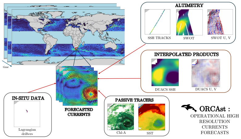
The architecture is a multi-arm encoder-decoder built on the SimVP video-prediction structure, with one 2D encoder per input variable, one 2D decoder per output variable, a learned spatio-temporal positional embedding, and a Gated Spatio-Temporal attention (GSTa) translator that learns temporal dynamics through gated attention and dilated convolutions. The load-bearing mechanism is the three-stage training schedule with masking, which lets the network first learn large-scale fields from abundant nadir altimetry, then add fine-scale structure from wide-swath altimetry, and finally learn total, ageostrophic currents from sparse drifter observations while the loss is weighted by current magnitude.
What would settle it
Evaluate ORCAst against the same three comparison products on all 2023 drifter observations without the 0.25 m/s magnitude filter, and separately on ship-based current estimates; if the angle and magnitude margins shrink, reverse, or fail to generalize to slower currents, the headline claim is specific to energetic flows rather than to ocean surface currents in general.
Extended reading notes
Core claim
ORCAst forecasts sea surface height and the U and V components of surface currents through a three-stage training curriculum: it first learns masked regression on along-track nadir altimetry and delayed-time geostrophic currents, then refines on high-resolution wide-swath altimetry targets, then fine-tunes only the current output heads against sparse Lagrangian drifter velocities while freezing the sea-surface-height decoder. Each stage adds measurable skill: correct-angle accuracy at next day rises from 79% to 83% to 85%, and at seven days from 64% to 68% to 70%. On the global extratropical evaluation set, ORCAst reaches 85% correct angle and 77% correct magnitude at T+1 and 70% and 69% at T+7, exceeding the persistence forecasts of the two delayed-time products and the near-real-time numerical forecast. Regionally trained variants improve further, most strongly in the Mediterranean Sea and at the seven-day lead time in the Gulf Stream and Agulhas regions, where the model also locates and evolves mesoscale eddies more accurately than the numerical baseline.
Load-bearing premise
The reported skill is measured only on drifters moving faster than 0.25 m/s, and the training loss is deliberately weighted by current magnitude, so the claim of superior current forecasting rests on skill in strong, eddy-like flows transferring to the slower currents that dominate the ocean surface.
Editorial extensions
If this is right
- If the reported skill holds, operational near-real-time current forecasts at 1/30° resolution can be produced from observations alone, without assimilating observations into a numerical ocean model and without waiting for delayed-time data.
- Delayed-time products that use six to fourteen days of future altimetry lose their assumed accuracy advantage even at next-day lead time, since ORCAst uses only data available up to the forecast start.
- Regional fine-tuning is an effective specialization strategy: a Mediterranean-trained model improves next-day correct angle from 77% to 85% and seven-day correct magnitude from 59% to 83% over the global model.
- The two delayed-time products and the numerical forecast all fall below ORCAst at seven days in the energetic Gulf Stream and Agulhas regions, suggesting the model captures eddy evolution rather than merely persisting present conditions.
- Because SWOT data as training targets, not inputs, drove the largest stage-to-stage gains, accumulating more SWOT years is the most direct route to further mesoscale and submesoscale improvement.
Reading between the lines
- The evaluation threshold of 0.25 m/s means the headline margins apply to energetic, eddy-like flows; whether the advantage persists on the slower currents that cover most of the ocean surface is untested and would require an unfiltered drifter sample.
- The ship-data comparison suggests a concrete commercial payoff: if ORCAst current fields track observed SOG-STW more closely than the numerical forecast, route optimizers could use them directly, and a controlled routing trial on AIS data would quantify the fuel or time savings.
- The authors note that regression forecasts are smoothed, so the same three-stage curriculum applied to a generative model such as diffusion or flow matching could provide ensemble forecasts and a fuller conditional distribution of currents.
- The equatorial band between 20°S and 20°N is the main geographic hole; training on assimilated numerical targets in that band, as the paper suggests, is a natural test of whether the method extends beyond the geostrophic approximation.
Signed reviews
Editorial analysis
A structured set of objections, weighed in public.
Referee Report
Summary. The paper introduces ORCAst, a multi-stage encoder-decoder model that maps 11 days of satellite observations (nadir SSH, SWOT, SST, and optionally CHL) to 7-day forecasts of SSH and surface current components at 1/30° resolution. Training proceeds in three stages: regression to DUACS geostrophic currents and nadir SSH, then to SWOT SSH and currents, then to sparse drifter velocities, with all losses MSE-weighted by current magnitude. The model is evaluated on held-out 2023 drifter observations with speed greater than 0.25 m/s and compared against DUACS, NeurOST (both with persistence at T+7), and the Mercator operational forecast. The paper reports consistent improvements at T+1 and T+7, gains from regional training, ablations on CHL and SWOT inputs, and a single-voyage ship-data illustration.
Significance. If the headline results hold, ORCAst would be a practically important demonstration that a purely observational deep-learning model can provide operational nowcasts and 7-day forecasts that beat a numerical ocean forecast system (Mercator) and delayed-time gridded products at higher resolution. The work has clear strengths: evaluation on held-out 2023 drifters, an explicit multi-stage ablation showing incremental gains, a sensible masking strategy for sparse altimetry, and candid discussion of limitations including SWOT input overlap and NeurOST data quality. However, the central empirical claim currently rests on a speed-filtered evaluation coupled to magnitude-weighted training, and the reported margins are mostly small and unaccompanied by uncertainty estimates. The significance would be substantially strengthened by a speed-stratified or unfiltered evaluation.
major comments (5)
- [Sections 3.2 and 3.4, Table 2] The evaluation set is restricted to drifters with speed greater than 0.25 m/s, while the Stage 3 loss is weighted proportionally to current magnitude. Because ORCAst is explicitly optimized to fit fast currents and then tested mainly on fast currents, the reported advantage over DUACS, NeurOST, and Mercator may not transfer to the bulk of the drifter population. The abstract and conclusions make general claims of superior current forecasting without this speed qualifier. Please report results on the full 2023 drifter set and on speed strata (e.g., below 0.25, 0.25–0.5, and above 0.5 m/s) for all baselines; if the filter is retained, it should be justified as a target-application choice rather than a general skill claim.
- [Table 2 and Section 4.1] No error bars, confidence intervals, or significance tests are provided for any comparison. Several margins are small (e.g., 85% versus 83% correct angle at T+1 for ORCAst versus NeurOST; MEVA 24 versus 25 cm/s), and the number of drifter observations per region and lead time is not reported. Because these differences are used to support the central claim of consistent superiority, please add bootstrap or cluster-based uncertainty estimates over drifters and regions and state whether the reported differences are statistically distinguishable.
- [Section 3.4 and Table 2] The T+7 comparison treats DUACS and NeurOST with persistence forecasting, which is a weak baseline for a 7-day forecast of evolving eddies. While the comparison to Mercator forecasts is more convincing, the phrase "consistently outperforms the baselines" overstates the evidence. Please either add a stronger forecast baseline (e.g., advection of the T+1 field with altimetry-derived velocities or a simple optical-flow forecast) or qualify the claims with respect to the persistence baselines.
- [Section 4.5 and Figure 12] The ship-data evaluation is a single trans-Mediterranean voyage, and the claim that it demonstrates practical applicability is anecdotal. Please provide aggregated metrics over multiple voyages or at least a quantitative statement of the mismatch shown in Figure 12. This is not essential to the main current-skill claim, but it is presented as supporting evidence for operational value.
- [Section 5.1, Table 8] The paper itself states that "as there is little overlap between the SWOT measurements in 2023 and the drifter trajectories used for validation we cannot demonstrate yet the effectiveness of using SWOT data as inputs" (Section 5.1). This limitation should be reflected in the results section and in the abstract, which currently emphasizes SWOT training without this caveat. The SWOT input experiment in Table 8 is accordingly inconclusive and should be framed as such rather than as evidence of flexibility.
minor comments (5)
- [Abstract and Introduction] The phrase "global ocean surface currents" is used without the extratropical qualifier in the abstract and introduction, while the model is trained and evaluated only outside 20°S–20°N. Please qualify these statements consistently.
- [Throughout] Several typos appear: "Aghulas" in Tables 5 and 6, "imited" in Section 1, "bottow" in Figure 10, and inconsistent spacing in "MEV A" in Tables 2–8 and Section 3.4.
- [Sections 3.1, 3.2, 4.1] References to "Appendix 5" should point to the actual appendix letters (A, B, C). For example, the positional embedding details are in Appendix A, the SWOT bias in Appendix B, and the ablation in Appendix C.
- [Table 8] The evaluation period for Table 8 (August–December 2023) differs from the other tables; this is explained in the text, but noting it directly in the caption would improve clarity.
- [Section 2.2] The footnote about NeurOST production issues is important for interpreting the baseline; consider moving it to the main text or to the data availability statement.
Circularity Check
No significant circularity: the central claim is tested against external, temporally held-out drifter observations.
full rationale
ORCAst's central claim—that it outperforms DUACS, NeurOST, and Mercator at T+1 and T+7 for ocean surface current forecasts—is supported by an evaluation on 2023 drifter observations that were not used in any training stage: the paper states training uses data from 2016 to mid-December 2018 and mid-January 2020–2022 in Stages 1 and 3, SWOT data from 2024 in Stage 2, and reserves 2023 for evaluation. The baselines are external products (DUACS, NeurOST, Mercator), not quantities derived from ORCAst's own fitted parameters. The magnitude-weighted MSE loss (Section 3.2, following Kugusheva et al. 2024) and the >0.25 m/s evaluation filter (Section 3.4) are aligned in emphasizing fast currents, which raises a legitimate external-validity concern about generalization to slower currents, but this is not circular: the 2023 drifter velocities are not used to fit the model, and the reported metrics are not arithmetically forced by the training objective. Stage 3 does fine-tune on drifters and Stage 3 is evaluated on drifters, but the temporal holdout preserves independence of the evaluation. Self-citations (Archambault et al.; Filoche et al.; Kugusheva et al.) support the masking, multi-stage, and loss-weighting methodology, yet the headline comparison to DUACS/NeurOST/Mercator does not reduce to those citations; it stands on the held-out observational benchmark. No equation in the paper defines a predicted quantity in terms of the fitted target, and no uniqueness theorem is invoked to forbid alternatives. Hence no circular step meets the evidence threshold.
Assumptions & free parameters
free parameters (6)
- Training epochs per stage (Stage 1/2/3) =
1000/200/50 global; 500/200/25 Mediterranean
- Learning rate and weight decay =
1e-3, 1e-3 in Stage 1; reduced by 10x in Stages 2/3
- Spatial resolution and patch size =
1/30 degree; 128x128 crops
- Input and output time steps =
T=11 days input, tau=7 days output
- Current-magnitude loss weighting =
Proportional to target current magnitude, exact formula not given
- Evaluation thresholds =
Speed filter >0.25 m/s; angle error <=45 degrees; magnitude error <=2.5 cm/s
assumptions (5)
- domain assumption Geostrophic balance is a valid approximation for deriving surface currents from sea surface height outside the tropics.
- domain assumption Sea surface temperature and chlorophyll are passive tracers advected by surface currents, so their spatial patterns contain usable information about current structure.
- domain assumption Drogued drifter velocities, after 24-hour averaging, are unbiased measurements of the true surface current at the model grid scale.
- domain assumption The temporal train/test split (training on 2016-2022, evaluation on 2023) makes the evaluation independent of the training distribution.
- domain assumption The neural network architecture (SimVP-style encoder-decoder with GSTa attention) is trainable and expressive enough to approximate the current-forecast mapping.
Cite this review
Pith. "Pith review of ORCAst: Operational High-Resolution Current Forecasts." pith.science (2026). https://pith.science/paper/J53DTHNV
@misc{pith2026250112054,
  author       = {Pith},
  title        = {Pith review of: ORCAst: Operational High-Resolution Current Forecasts},
  year         = {2026},
  howpublished = {\url{https://pith.science/paper/J53DTHNV}},
  note         = {Machine review of arXiv:2501.12054}
}
read the original abstract
We present ORCAst, a multi-stage, multi-arm network for Operational high-Resolution Current forecAsts over one week. Producing real-time nowcasts and forecasts of ocean surface currents is a challenging problem due to indirect or incomplete information from satellite remote sensing data. Entirely trained on real satellite data and in situ measurements from drifters, our model learns to forecast global ocean surface currents using various sources of ground truth observations in a multi-stage learning procedure. Our multi-arm encoder-decoder model architecture allows us to first predict sea surface height and geostrophic currents from larger quantities of nadir and SWOT altimetry data, before learning to predict ocean surface currents from much more sparse in situ measurements from drifters. Training our model on specific regions improves performance. Our model achieves stronger nowcast and forecast performance in predicting ocean surface currents than various state-of-the-art methods.
Figures


Figures from the paper (10 more)


Reference graph
Works this paper leans on
-
[1]
URL https://podaac.jpl.nasa.gov/dataset/L3S_LEO_DY-STAR-v2.81
GHRSST NOAA/STAR ACSPO v2.81 0.02 degree L3S Daily Dataset from LEO Satellites. URL https://podaac.jpl.nasa.gov/dataset/L3S_LEO_DY-STAR-v2.81 . A. E. Aouni, Q. Gaudel, C. Regnier, S. Van Gennip, M. Drevillon, Y . Drillet, and J.-M. Lellouche. Glonet: Mercator’s end-to-end neural forecasting system. arXiv preprint arXiv:2412.05454,
-
[4]
doi: 10.1038/s41612-023-00512-1
ISSN 2397-3722. doi: 10.1038/s41612-023-00512-1. URL https://www.nature.com/articles/s41612-023-00512-1 . Publisher: Nature Publishing Group. D. Ciani, C. Fanelli, and B. Buongiorno Nardelli. Estimating ocean currents from the joint recon- struction of absolute dynamic topography and sea surface temperature through deep learning algorithms. EGUsphere, pag...
-
[6]
Product ID: SEALEVEL_GLO_PHY_L4_MY_008_047
URL https: //doi.org/10.48670/moi-00148. Product ID: SEALEVEL_GLO_PHY_L4_MY_008_047. Copernicus Marine Service. Global Ocean Along Track L3 Sea Surface Heights NRT. Satellite observations, NetCDF-4 format, 11
-
[7]
Product ID: SEALEVEL_GLO_PHY_L3_NRT_008_044
URL https://doi.org/10.48670/moi-00147. Product ID: SEALEVEL_GLO_PHY_L3_NRT_008_044. Copernicus Marine Service. European Seas Gridded L4 Sea Surface Heights And Derived Variables NRT. Satellite observations, NetCDF-4 format, 11
-
[10]
ISSN 1942-2466. doi: 10.1029/2023MS003609. URL https://onlinelibrary.wiley.com/doi/abs/10.1029/2023MS003609. _eprint: https://onlinelibrary.wiley.com/doi/pdf/10.1029/2023MS003609. A. Filoche, T. Archambault, A. Charantonis, and D. Béréziat. Statistics-free interpolation of ocean observations with deep spatio-temporal prior. In ECML/PKDD Workshop on Machin...
-
[11]
Z. Gao, C. Tan, L. Wu, and S. Z. Li. Simvp: Simpler yet better video prediction. In 2022 IEEE/CVF Conference on Computer Vision and Pattern Recognition (CVPR) , pages 3160–3170,
work page 2022
-
[13]
Product ID: IN- SITU_GLO_PHYBGCW A V_DISCRETE_MYNRT_013_030
URL https://doi.org/10.48670/moi-00036. Product ID: IN- SITU_GLO_PHYBGCW A V_DISCRETE_MYNRT_013_030. D. P. Kingma and J. Ba. Adam: A method for stochastic optimization. In International Conference on Learning Representations (ICLR),
-
[14]
ISSN 2072-4292. doi: 10.3390/rs16071182. URL https://www.mdpi.com/2072-4292/16/7/1182. R. Lam, A. Sanchez-Gonzalez, M. Willson, P. Wirnsberger, M. Fortunato, F. Alet, S. Ravuri, T. Ewalds, Z. Eaton-Rosen, W. Hu, A. Merose, S. Hoyer, G. Holland, O. Vinyals, J. Stott, A. Pritzel, S. Mohamed, and P. Battaglia. Learning skillful medium-range global weather fo...
Show all 29 references
-
[15]
doi: 10.1126/science.adi2336
ISSN 1095-9203. doi: 10.1126/science.adi2336. F. Le Guillou, L. Gaultier, M. Ballarotta, S. Metref, C. Ubelmann, E. Cosme, and M.-H. Rio. Regional mapping of energetic short mesoscale ocean dynamics from altimetry: performances from real observations. Ocean Science, 19(5):1517...
-
[16]
doi: 10.1029/2022MS003589
ISSN 1942-2466. doi: 10.1029/2022MS003589. 24 URL https://onlinelibrary.wiley.com/doi/abs/10.1029/2022MS003589. _eprint: https://onlinelibrary.wiley.com/doi/pdf/10.1029/2022MS003589. S. A. Martin, G. E. Manucharyan, and P. Klein. Deep Learning Improves Global Satellite Observa...
1942 doi
-
[17]
doi: 10.1029/2024GL110059
ISSN 1944-8007. doi: 10.1029/2024GL110059. URL https://onlinelibrary.wiley.com/doi/abs/10.1029/2024GL110059. _eprint: https://onlinelibrary.wiley.com/doi/pdf/10.1029/2024GL110059. Mercator Océan International. Global Ocean Physics Analysis and Fore- cast,
1944 doi
-
[18]
Product ID: GLOBAL_ANALYSISFORECAST_PHY_001_024
URL https://doi.org/10.48670/moi-00016. Product ID: GLOBAL_ANALYSISFORECAST_PHY_001_024. MET Norway. Mediterranean Sea - High Resolution and Ultra High Resolution L3S Sea Surface Temperature,
-
[19]
URL https://doi.org/10.48670/moi-00171. Processing Level: 3; Spatial Coverage: Mediterranean Sea (Lat 30.25° to 46°, Lon -18.12° to 36.25°); Spatial Resolution: 0.01° × 0.01°; Temporal Coverage: 1 Jan 2008 to 17 Dec 2024; Update Frequency: Daily; Format: NetCDF-4. R. Morrow, D...
2008 doi
-
[20]
https://doi.org/10.24400/527896/A01-2023.018. J. O’Reilly, S. Maritorena, B. Mitchell, D. Siegel, K. Carder, S. Garver, M. Kahru, and C. Mcclain. Ocean color chlorophyll algorithms for SeaWiFS. Journal of Geophysical Research, 103:937–953, Oct
2023 doi
-
[22]
org/10.5067/NEURO-STV24
URL https://doi. org/10.5067/NEURO-STV24. Start/Stop Date: 2010-Jan-01 to 2024-Jun-15; Format: netCDF-4; Processing Level:
2010 doi
-
[23]
doi: 10.5194/os-15-1207-2019
ISSN 1812-0784. doi: 10.5194/os-15-1207-2019. URL https://os.copernicus.org/articles/15/1207/2019/. Publisher: Copernicus GmbH. B. D. Tapley, G. H. Born, and M. E. Parke. The seasat altimeter data and its accuracy assessment. Journal of Geophysical Research: Oceans , 87(C5):3179–3188,
2019 doi
-
[24]
doi: 10.1016/ j.ocemod.2023.102174
ISSN 1463-5003. doi: 10.1016/ j.ocemod.2023.102174. URL https://www.sciencedirect.com/science/article/pii/ S146350032300015X. M. Tonani, M. Balmaseda, L. Bertino, E. Blockley, G. Brassington, F. Davidson, Y . Drillet, P. Hogan, T. Kuragano, T. Lee, A. Mehra, F. Paranathara, C....
2023
-
[26]
doi: 10.5194/os-18-469-2022
ISSN 1812-0784. doi: 10.5194/os-18-469-2022. URL https://os.copernicus.org/articles/ 18/469/2022/. Publisher: Copernicus GmbH. 25 W. Wang, E. Xie, X. Li, D.-P. Fan, K. Song, D. Liang, T. Lu, P. Luo, and L. Shao. PVT v2: Improved baselines with Pyramid Vision Transformer. Compu...
2022 doi
-
[27]
doi: 10.1007/s41095-022-0274-8
ISSN 2096-0662. doi: 10.1007/s41095-022-0274-8. URL https://doi.org/10.1007/ s41095-022-0274-8 . X. Wang, R. Wang, N. Hu, P. Wang, P. Huo, G. Wang, H. Wang, S. Wang, J. Zhu, J. Xu, J. Yin, S. Bao, C. Luo, Z. Zu, Y . Han, W. Zhang, K. Ren, K. Deng, and J. Song. XiHe: A Data-Dri...
-
[28]
arXiv:2402.02995 [physics]
URL http://arxiv.org/ abs/2402.02995. arXiv:2402.02995 [physics]. Y . Wu and K. He. Group Normalization.International Journal of Computer Vision, 128(3):742–755, Mar
-
[30]
doi: 10.1109/CVPR52688.2022.01055. 26
2022
-
[1998]
A. M. Scott, E. M. Georgy, and K. Patrice. NeurOST Level 4 Sea Surface Height and Surface Geostrophic Currents Analysis Product (Version 2024.0). Daily mapped neural network product using Level 3 altimetry observations and MUR Level 4 SST, 08
2024
-
[2015]
doi: 10.1080/1755876X.2015.1049892
ISSN 1755-876X. doi: 10.1080/1755876X.2015.1049892. URL https://doi.org/10.1080/1755876X.2015.1049892. Publisher: Taylor & Francis _eprint: https://doi.org/10.1080/1755876X.2015.1049892. C. Ubelmann, L. Carrere, C. Durand, G. Dibarboure, Y . Faugère, M. Ballarotta, F. Briol, a...
2015
-
[2016]
doi: 10.1002/2016JC011716. 23 S. Elipot, A. Sykulski, R. Lumpkin, L. Centurioni, and M. Pazos. Hourly location, current velocity, and temperature collected from Global Drifter Program drifters world-wide. Dataset,
-
[2019]
URL https://link.aps.org/doi/10.1103/PhysRevFluids.4
doi: 10.1103/ PhysRevFluids.4.103907. URL https://link.aps.org/doi/10.1103/PhysRevFluids.4. 103907. Publisher: American Physical Society. L. Chen, X. Zhong, F. Zhang, Y . Cheng, Y . Xu, Y . Qi, and H. Li. FuXi: a cascade machine learning forecasting system for 15-day global we...
-
[2020]
doi: 10.1007/s11263-019-01198-w
ISSN 1573-1405. doi: 10.1007/s11263-019-01198-w. URL https://doi.org/10. 1007/s11263-019-01198-w . W. Yu, M. Luo, P. Zhou, C. Si, Y . Zhou, X. Wang, J. Feng, and S. Yan. Metaformer is actually what you need for vision. In 2022 IEEE/CVF Conference on Computer Vision and Pattern...
- [2022]
-
[2023]
Archambault, A
T. Archambault, A. Filoche, A. Charantonis, and D. Béréziat. Pre-training and Fine-tuning Attention Based Encoder Decoder Improves Sea Surface Height Multi-variate Inpainting. In VISAPP 2024 - 19th International Conference on Computer Vision Theory and Applications , Roma, Ita...
2024
-
[2024]
URL https://egusphere.copernicus.org/preprints/2024/egusphere-2024-1164/
doi: 10.5194/egusphere-2024-1164. URL https://egusphere.copernicus.org/preprints/2024/egusphere-2024-1164/ . Pub- lisher: Copernicus GmbH. Copernicus Climate Service. Global Ocean Gridded L4 Sea Surface Heights And Derived Variables Reprocessed 1993 Ongoing. Satellite observat...
2024 doi
Reviewed August 10, 2026 · model on record in the stance chip above.
Discussion (0). Continue with ORCID to comment.