REVIEW 3 major objections 5 minor 43 references
GeoGrid-Bench: Can Foundation Models Understand Multimodal Gridded Geo-Spatial Data?
T0 review · 3 major / 5 minor · reviewed 2026-08-15 · deepseek-v4-flash
Pith's one-line read GeoGrid-Bench, a roughly 3,200-question benchmark built on real climate projections, shows that foundation models understand gridded geo-spatial data best when it is shown as heatmaps, not tables or code.
desk verdict A genuinely useful benchmark for gridded climate data, but the oracle-generated ground truth needs visible validation before the accuracy numbers can be trusted. read the letter →
The pith
A machine-rendered reading of the paper's core claim, the machinery that carries it, and where it could break.
The reading
What carries the argument
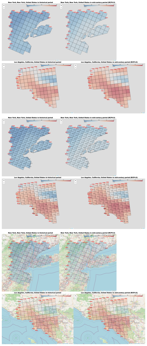
The benchmark's working parts are the eight expert-curated question templates and the oracle code paired with each one. Given a template, sampled climate variables, locations, and time frames from a real-world gridded climate dataset, the oracle deterministically computes the correct answer and generates four multiple-choice options, so a single validated template yields many reliable instances. Each instance is rendered in four modalities: a table as text, a bare heatmap, a heatmap with per-cell numerical annotations, and a heatmap overlaid on a geographic base map. Answer options are classified by which aspect they test: overall pattern, spatial region, coordinate reference, or map-label reference. The evaluation protocol compares language-only, language-plus-code, and language-plus-vision input settings.
What would settle it
Take a random sample of about 200 GeoGrid-Bench instances, have climate-domain experts independently derive the correct multiple-choice option from the raw grid data, then compare their labels with the oracle's; if expert agreement falls below the reported model accuracies, the ground truths do not support the paper's conclusions. A second check is to re-present the vision questions with the four options in different orders and see whether accuracy moves, which would indicate position bias rather than genuine spatial understanding.
Extended reading notes
Core claim
On its own terms, the paper claims that foundation models understand gridded geo-spatial data best when the data is presented as a heatmap image rather than as a dense numerical table or as a prompt to generate analysis code. Across the evaluated commercial and open-source models, vision-language input consistently outperformed language-only input, and code-based performance was inferior, with many generated scripts failing to execute in a single pass. The paper also finds that all models are better at identifying overall trends than at fine-grained references to spatial regions, row/column coordinates, or map labels, and that adding numerical annotations to heatmaps helps while overlaying heatmaps on geographic base maps hurts. These results are presented as evidence about how to build practical AI-assisted tools for geo-spatial and climate analysis.
Load-bearing premise
The benchmark's validity rests on the oracle code producing a correct and unambiguous answer for every generated instance, and the paper reports no independent human validation of that code.
Editorial extensions
If this is right
- For current foundation models, presenting gridded climate data as heatmaps is a more effective interface than tables or one-shot code generation.
- The template-plus-oracle pipeline lets the benchmark scale beyond its current 3,200 instances without new human annotation.
- Fine-grained spatial, coordinate, and label reasoning is a distinct weakness of current models that trend-level accuracy alone does not expose.
- Code-based geo-spatial analysis by foundation models is not yet reliable enough for single-shot use by domain scientists, pointing to agentic models as the next step.
Reading between the lines
- A natural test of the central finding is to apply the same template-oracle pipeline to non-climate gridded data, such as demographic or geophysical grids; if heatmaps still win, the vision advantage is about grids generally, while a failure would point to map-specific color conventions.
- An independent human audit of a random sample of oracle-generated answers would directly test whether the reported accuracies reflect model skill or artifacts of the answer-generation code.
- Because annotated heatmaps helped and map overlays hurt, ablating visual clutter (label density, color scale, grid-line width) could isolate exactly which visual features drive the vision-language advantage.
Signed reviews
Editorial analysis
A structured set of objections, weighed in public.
Referee Report
Summary. GeoGrid-Bench introduces a benchmark for evaluating foundation models on gridded geo-spatial data. Built from the ClimRR climate dataset, it spans 16 climate variables, 150 North American locations, and roughly 3,200 multiple-choice question-answer pairs generated from 8 domain-expert-curated templates. Each question is rendered in tabular and three image formats (heatmap, annotated heatmap, and map-overlaid heatmap), and answers are produced deterministically by oracle code targeting four answer aspects: overall trend, spatial reference, coordinate reference, and label reference. The paper evaluates 11 models (OpenAI and open-source) in language-only, code, and vision settings, reporting that vision-language models perform best overall, code-based performance is inferior, and fine-grained spatial/label reasoning is harder than trend identification. The central claims are that GeoGrid-Bench is a valid, reusable benchmark and that the VLM-over-text advantage is a real property of current foundation models.
Significance. If the benchmark construction is sound, GeoGrid-Bench fills a genuine gap: existing geo-spatial benchmarks focus on remote-sensing imagery or GIS/SQL retrieval, whereas gridded climate data with dense numerical values and multimodal presentations is underexplored. The paper's strengths include the use of real-world ClimRR data, public release of code and data, deterministic oracle-based answer generation, a broad model sweep (11 models), and fine-grained evaluation across answer aspects and visualization formats. The central VLM-over-text finding, if statistically robust, would be a practically useful result for designing AI-assisted climate analysis tools. However, the validity of every reported accuracy number depends on the correctness and uniqueness of oracle-generated ground truth, and the manuscript does not yet provide the validation evidence needed to underwrite that dependency.
major comments (3)
- [Section 3.2] The validity of the entire benchmark rests on the oracle code, which is the sole source of ground truth and of all four multiple-choice options. The paper states 'once a template and its oracle are validated, we ensure the quality of every generated instance,' but no validation procedure, human audit, inter-annotator agreement, or error analysis is reported anywhere in the paper or appendix. If any oracle routine has a systematic bug, or if option construction yields cases with zero or two correct answers, then all 3,200 instances and every accuracy number in Figures 4-6 are affected. This is a load-bearing correctness risk, not a stylistic issue. Please add a concrete validation protocol, such as a human audit on a stratified sample of instances per template, automated checks that exactly one option is correct, and an error analysis of any generated instances that fail these checks.
- [Section 4.2, Figures 4-6] The evaluation reports accuracy numbers from a single decoding run per model/setting with default temperature, and no variance estimates, confidence intervals, or statistical tests are provided. Given that each template has only 100 instances and that fine-grained columns (e.g., coordinate or label references) split the data further, the observed differences—such as the claimed VLM advantage over language-only or the differences among image formats—could plausibly arise from sampling noise. Please report multiple runs (or bootstrap resamples) with confidence intervals, or apply a significance test, so that the central empirical claims are quantifiably supported.
- [Table 1 and Section 3.2] Several templates rely on qualitative terms whose operational definitions in the oracle are not specified: 'largest increase' (Template 1), 'greater change' (Template 7), and 'correlation' thresholds (Template 3) such as what counts as strong versus weak correlation. Without precise operationalizations, another group cannot reproduce the oracle rules or verify that the generated answers match the intent of the domain experts. Please state the exact oracle decision rules for each template, including all thresholds and criteria used to select the correct option and to construct distractors.
minor comments (5)
- [Abstract and Figure 1 caption] The abstract and the Figure 1 caption both use 'find-grained'; this should be 'fine-grained'.
- [Section 1] In the first paragraph of the introduction, 'Most existing efforts docus on' should read 'Most existing efforts focus on'.
- [Appendix B, Figures 7-13] The appendix captions repeatedly refer to 'maximum annual temperate' and 'minimum annual temperate'; these should be 'temperature'.
- [Figure 12 caption] The caption for Figure 12 says 'time_frame1 = historical period, and time_frame1 = mid-century period (RCP4.5)'; the second should be time_frame2.
- [Section 3.1] The data statistics say 50 locations are associated with each of 16 climate variables, which would imply 800 location-variable pairs, while the text also says there are 150 distinct locations. Please clarify how locations are shared across variables and how the 50-per-variable count relates to the 150 unique locations.
Circularity Check
No circular derivation found; the benchmark construction and model evaluation are self-contained, and self-citations are not load-bearing.
full rationale
GeoGrid-Bench does not derive any quantitative claim from its own inputs by construction. Ground-truth answers are produced by deterministic oracle code from ClimRR data and expert-curated templates, not fitted to or predicted from the evaluated models. The central evaluation finding, that vision-language models achieve the strongest performance, is an empirical measurement over 11 models and 3,200 instances, not an algebraic consequence of the benchmark's definitions. The assertion in Section 3.2 that "once a template and its oracle are validated, we ensure the quality of every generated instance" is an unverified correctness assumption, but lack of validation is a validity risk, not circularity; it would affect all measured accuracies if the oracle had systematic bugs. Self-citations in Sections 1 and 5 are contextual and do not carry the benchmark's load-bearing argument. No equation is recycled as a prediction, no fitted parameter is renamed as a result, and no uniqueness theorem is imported from the authors' prior work. Accordingly, the circularity score is 0.
Assumptions & free parameters
assumptions (5)
- domain assumption ClimRR climate projection data accurately represents the real-world quantities used as benchmark inputs and answers.
- ad hoc to paper Oracle code deterministically computes correct answers and generates one unambiguous correct option among four plausible choices.
- domain assumption Eight templates produced by 13 domain experts are representative of practical geo-spatial analysis tasks.
- domain assumption Single-run evaluation with default temperature and current API model versions is representative of model capability.
- ad hoc to paper Choosing locations where each variable is 'most prominent' does not distort the measured capability profile.
Cite this review
Pith. "Pith review of GeoGrid-Bench: Can Foundation Models Understand Multimodal Gridded Geo-Spatial Data?." pith.science (2026). https://pith.science/paper/RE4WJT35
@misc{pith2026250510714,
  author       = {Pith},
  title        = {Pith review of: GeoGrid-Bench: Can Foundation Models Understand Multimodal Gridded Geo-Spatial Data?},
  year         = {2026},
  howpublished = {\url{https://pith.science/paper/RE4WJT35}},
  note         = {Machine review of arXiv:2505.10714}
}
read the original abstract
We present GeoGrid-Bench, a benchmark designed to evaluate the ability of foundation models to understand geo-spatial data in the grid structure. Geo-spatial datasets pose distinct challenges due to their dense numerical values, strong spatial and temporal dependencies, and unique multimodal representations including tabular data, heatmaps, and geographic visualizations. To assess how foundation models can support scientific research in this domain, GeoGrid-Bench features large-scale, real-world data covering 16 climate variables across 150 locations and extended time frames. The benchmark includes approximately 3,200 question-answer pairs, systematically generated from 8 domain expert-curated templates to reflect practical tasks encountered by human scientists. These range from basic queries at a single location and time to complex spatiotemporal comparisons across regions and periods. Our evaluation reveals that vision-language models perform best overall, and we provide a fine-grained analysis of the strengths and limitations of different foundation models in different geo-spatial tasks. This benchmark offers clearer insights into how foundation models can be effectively applied to geo-spatial data analysis and used to support scientific research.
Figures


Figures from the paper (10 more)



Reference graph
Works this paper leans on
-
[4]
Assessing large language models on climate information
Jannis Bulian, Mike S Schäfer, Afra Amini, Heidi Lam, Massimiliano Ciaramita, Ben Gaiarin, Michelle Chen Huebscher, Christian Buck, Niels G Mede, Markus Leippold, et al. Assessing large language models on climate information. arXiv preprint arXiv:2310.02932,
-
[5]
Charles Cao, Jie Zhuang, and Qiang He. LLM-assisted modeling and simulations for public sector decision-making: Bridging climate data and policy insights. In AAAI-2024 Workshop on Public Sector LLMs: Algorithmic and Sociotechnical Design,
work page 2024
-
[6]
Optimizing ai-driven disaster management through llms
Wei Chen and Jiing Fang. Optimizing ai-driven disaster management through llms. DOI:10.20944/preprints202407.1446.v1,
-
[7]
Tabfact: A large-scale dataset for table-based fact verification
Wenhu Chen, Hongmin Wang, Jianshu Chen, Yunkai Zhang, Hong Wang, Shiyang Li, Xiyou Zhou, and William Yang Wang. Tabfact: A large-scale dataset for table-based fact verification. arXiv preprint arXiv:1909.02164,
arXiv 1909
-
[11]
Geobench-vlm: Benchmarking vision-language models for geospatial tasks
Muhammad Sohail Danish, Muhammad Akhtar Munir, Syed Roshaan Ali Shah, Kartik Kuckreja, Fahad Shahbaz Khan, Paolo Fraccaro, Alexandre Lacoste, and Salman Khan. Geobench-vlm: Benchmarking vision-language models for geospatial tasks. arXiv preprint arXiv:2411.19325,
-
[12]
Information Retrieval for Climate Impact
Maarten de Rijke, Bart van den Hurk, Flora Salim, Alaa Al Khourdajie, Nan Bai, Renato Calzone, Declan Curran, Getnet Demil, Lesley Frew, Noah Gießing, et al. Information retrieval for climate impact. arXiv preprint arXiv:2504.01162,
-
[13]
Tables as texts or images: Evaluating the table reasoning ability of llms and mllms
Naihao Deng, Zhenjie Sun, Ruiqi He, Aman Sikka, Yulong Chen, Lin Ma, Yue Zhang, and Rada Mihalcea. Tables as texts or images: Evaluating the table reasoning ability of llms and mllms. arXiv preprint arXiv:2402.12424,
-
[14]
Large language models (llms) on tabular data: Prediction, generation, and understanding–a survey
11 Xi Fang, Weijie Xu, Fiona Anting Tan, Jiani Zhang, Ziqing Hu, Yanjun Qi, Scott Nickleach, Diego Socolinsky, Srinivasan Sengamedu, and Christos Faloutsos. Large language models (llms) on tabular data: Prediction, generation, and understanding–a survey. arXiv preprint arXiv:2402.17944,
Show all 43 references
-
[15]
Version 0.14.0
URL https://python-visualization.github.io/folium/ latest/. Version 0.14.0. Vinicius G Goecks and Nicholas R Waytowich. Disasterresponsegpt: Large language models for accel- erated plan of action development in disaster response scenarios. arXiv preprint arXiv:2306.17271,
-
[16]
The llama 3 herd of models
Aaron Grattafiori, Abhimanyu Dubey, Abhinav Jauhri, Abhinav Pandey, Abhishek Kadian, Ahmad Al-Dahle, Aiesha Letman, Akhil Mathur, Alan Schelten, Alex Vaughan, et al. The llama 3 herd of models. arXiv preprint arXiv:2407.21783,
-
[17]
Give: Structured reasoning with knowledge graph inspired veracity extrapolation
Jiashu He, Mingyu Derek Ma, Jinxuan Fan, Dan Roth, Wei Wang, and Alejandro Ribeiro. Give: Structured reasoning with knowledge graph inspired veracity extrapolation. arXiv preprint arXiv:2410.08475, 2024a. Xinyi He, Mengyu Zhou, Xinrun Xu, Xiaojun Ma, Rui Ding, Lun Du, Yan Gao,...
-
[18]
Gpt-4o system card
Aaron Hurst, Adam Lerer, Adam P Goucher, Adam Perelman, Aditya Ramesh, Aidan Clark, AJ Os- trow, Akila Welihinda, Alan Hayes, Alec Radford, et al. Gpt-4o system card. arXiv preprint arXiv:2410.21276,
-
[19]
Openai o1 system card
Aaron Jaech, Adam Kalai, Adam Lerer, Adam Richardson, Ahmed El-Kishky, Aiden Low, Alec Helyar, Aleksander Madry, Alex Beutel, Alex Carney, et al. Openai o1 system card. arXiv preprint arXiv:2412.16720,
-
[20]
A peek into token bias: Large language models are not yet genuine reasoners
Bowen Jiang, Yangxinyu Xie, Zhuoqun Hao, Xiaomeng Wang, Tanwi Mallick, Weijie J Su, Camillo J Taylor, and Dan Roth. A peek into token bias: Large language models are not yet genuine reasoners. arXiv preprint arXiv:2406.11050, 2024a. Bowen Jiang, Yangxinyu Xie, Xiaomeng Wang, Y...
-
[21]
Urbanllm: Au- tonomous urban activity planning and management with large language models
Yue Jiang, Qin Chao, Yile Chen, Xiucheng Li, Shuai Liu, and Gao Cong. Urbanllm: Au- tonomous urban activity planning and management with large language models. arXiv preprint arXiv:2406.12360, 2024e. Sayash Kapoor, Benedikt Stroebl, Zachary S Siegel, Nitya Nadgir, and Arvind N...
-
[22]
Geobenchx: Benchmarking llms for multistep geospatial tasks
12 Varvara Krechetova and Denis Kochedykov. Geobenchx: Benchmarking llms for multistep geospatial tasks. arXiv preprint arXiv:2503.18129,
-
[23]
Table-gpt: Table-tuned gpt for diverse table tasks
Peng Li, Yeye He, Dror Yashar, Weiwei Cui, Song Ge, Haidong Zhang, Danielle Rifinski Fainman, Dongmei Zhang, and Surajit Chaudhuri. Table-gpt: Table-tuned gpt for diverse table tasks. arXiv preprint arXiv:2310.09263,
-
[24]
Lost in the middle: How language models use long contexts
Nelson F Liu, Kevin Lin, John Hewitt, Ashwin Paranjape, Michele Bevilacqua, Fabio Petroni, and Percy Liang. Lost in the middle: How language models use long contexts. arXiv preprint arXiv:2307.03172,
-
[25]
Gair: Improving multimodal geo-foundation model with geo-aligned implicit representations
Zeping Liu, Fan Zhang, Junfeng Jiao, Ni Lao, and Gengchen Mai. Gair: Improving multimodal geo-foundation model with geo-aligned implicit representations. arXiv preprint arXiv:2503.16683,
-
[27]
Geollm: Extracting geospatial knowledge from large language models
Rohin Manvi, Samar Khanna, Gengchen Mai, Marshall Burke, David Lobell, and Stefano Er- mon. Geollm: Extracting geospatial knowledge from large language models. arXiv preprint arXiv:2310.06213,
-
[28]
Towards democratized flood risk management: An advanced ai assistant enabled by gpt-4 for enhanced interpretability and public engagement
Rafaela Martelo, Kimia Ahmadiyehyazdi, and Ruo-Qian Wang. Towards democratized flood risk management: An advanced ai assistant enabled by gpt-4 for enhanced interpretability and public engagement. arXiv preprint arXiv:2403.03188,
-
[29]
13 Andrew Ng
Accessed: 2025-04-17. 13 Andrew Ng. Welcoming diverse approaches keeps machine learning strong. June
2025
-
[30]
Tung Nguyen, Johannes Brandstetter, Ashish Kapoor, Jayesh K Gupta, and Aditya Grover
URL https://www.deeplearning.ai/the-batch/ welcoming-diverse-approaches-keeps-machine-learning-strong/ . Tung Nguyen, Johannes Brandstetter, Ashish Kapoor, Jayesh K Gupta, and Aditya Grover. Climax: A foundation model for weather and climate. arXiv preprint arXiv:2301.10343,
-
[31]
Accessed: 2025-04-18
URL https://openai.com/index/ o3-o4-mini-system-card/ . Accessed: 2025-04-18. OpenAI. Introducing gpt-4.1 in the api,
2025
-
[32]
Accessed: 2025-05-12
URL https://openai.com/index/gpt-4-1/ . Accessed: 2025-05-12. OpenStreetMap contributors. Openstreetmap,
2025
-
[33]
Accessed: 2025-05-12
URL https://www.openstreetmap.org/. Accessed: 2025-05-12. Ankur P Parikh, Xuezhi Wang, Sebastian Gehrmann, Manaal Faruqui, Bhuwan Dhingra, Diyi Yang, and Dipanjan Das. Totto: A controlled table-to-text generation dataset. arXiv preprint arXiv:2004.14373,
2025 arXiv
-
[34]
Compositional semantic parsing on semi-structured tables
Panupong Pasupat and Percy Liang. Compositional semantic parsing on semi-structured tables. arXiv preprint arXiv:1508.00305,
-
[36]
Sentence-bert: Sentence embeddings using siamese bert-networks
Nils Reimers and Iryna Gurevych. Sentence-bert: Sentence embeddings using siamese bert-networks. In Proceedings of the 2019 Conference on Empirical Methods in Natural Language Processing. Association for Computational Linguistics, 11
2019
-
[37]
URL https://arxiv.org/abs/1908. 10084. Bernd Resch, Polychronis Kolokoussis, David Hanny, Maria Antonia Brovelli, and Maged N Kamel Boulos. The generative revolution: Ai foundation models in geospatial health—applications, challenges and future research. International Journal ...
1908
-
[38]
Yuan Sui, Mengyu Zhou, Mingjie Zhou, Shi Han, and Dongmei Zhang
Accessed: 2025-04-17. Yuan Sui, Mengyu Zhou, Mingjie Zhou, Shi Han, and Dongmei Zhang. Table meets llm: Can large language models understand structured table data? a benchmark and empirical study. In Proceedings of the 17th ACM International Conference on Web Search and Data M...
2025
-
[39]
Climategpt: Towards ai synthesizing interdisciplinary research on climate change
David Thulke, Yingbo Gao, Petrus Pelser, Rein Brune, Rricha Jalota, Floris Fok, Michael Ramos, Ian van Wyk, Abdallah Nasir, Hayden Goldstein, et al. Climategpt: Towards ai synthesizing interdisciplinary research on climate change. arXiv preprint arXiv:2401.09646,
-
[41]
Hutchison, Duane R
Yangxinyu Xie, Bowen Jiang, Tanwi Mallick, Joshua David Bergerson, John K. Hutchison, Duane R. Verner, Jordan Branham, M. Ross Alexander, Robert B. Ross, Yan Feng, Leslie-Anne Levy, Weijie Su, and Camillo J. Taylor. A rag-based multi-agent llm system for natural hazard resilie...
-
[42]
Tablellama: Towards open large generalist models for tables
Tianshu Zhang, Xiang Yue, Yifei Li, and Huan Sun. Tablellama: Towards open large generalist models for tables. arXiv preprint arXiv:2311.09206, 2023a. Xuanliang Zhang, Dingzirui Wang, Longxu Dou, Qingfu Zhu, and Wanxiang Che. A survey of table reasoning with large language mod...
-
[43]
Geogpt: Understanding and processing geospatial tasks through an autonomous gpt
Yifan Zhang, Cheng Wei, Shangyou Wu, Zhengting He, and Wenhao Yu. Geogpt: Understanding and processing geospatial tasks through an autonomous gpt. arXiv preprint arXiv:2307.07930, 2023b. Yunjia Zhang, Jordan Henkel, Avrilia Floratou, Joyce Cahoon, Shaleen Deep, and Jignesh M P...
-
[2013]
Earthvqa: Towards queryable earth via relational reasoning-based remote sensing visual question answering
Junjue Wang, Zhuo Zheng, Zihang Chen, Ailong Ma, and Yanfei Zhong. Earthvqa: Towards queryable earth via relational reasoning-based remote sensing visual question answering. In Proceedings of the AAAI Conference on Artificial Intelligence, volume 38, pp. 5481–5489, 2024a. Zilo...
-
[2015]
Agentic large language models, a survey
Aske Plaat, Max van Duijn, Niki van Stein, Mike Preuss, Peter van der Putten, and Kees Joost Batenburg. Agentic large language models, a survey. arXiv preprint arXiv:2503.23037,
-
[2019]
Hy- bridqa: A dataset of multi-hop question answering over tabular and textual data
Wenhu Chen, Hanwen Zha, Zhiyu Chen, Wenhan Xiong, Hong Wang, and William Wang. Hy- bridqa: A dataset of multi-hop question answering over tabular and textual data. arXiv preprint arXiv:2004.07347,
2004 arXiv
-
[2020]
Finqa: A dataset of numerical reasoning over financial data
Zhiyu Chen, Wenhu Chen, Charese Smiley, Sameena Shah, Iana Borova, Dylan Langdon, Reema Moussa, Matt Beane, Ting-Hao Huang, Bryan Routledge, et al. Finqa: A dataset of numerical reasoning over financial data. arXiv preprint arXiv:2109.00122,
-
[2021]
Binding language models in symbolic languages
Zhoujun Cheng, Tianbao Xie, Peng Shi, Chengzu Li, Rahul Nadkarni, Yushi Hu, Caiming Xiong, Dragomir Radev, Mari Ostendorf, Luke Zettlemoyer, et al. Binding language models in symbolic languages. arXiv preprint arXiv:2210.02875,
-
[2022]
On the opportunities and challenges of foundation models for geospatial artificial intelligence
Gengchen Mai, Weiming Huang, Jin Sun, Suhang Song, Deepak Mishra, Ninghao Liu, Song Gao, Tianming Liu, Gao Cong, Yingjie Hu, et al. On the opportunities and challenges of foundation models for geospatial artificial intelligence. arXiv preprint arXiv:2304.06798,
-
[2023]
Shuai Bai, Keqin Chen, Xuejing Liu, Jialin Wang, Wenbin Ge, Sibo Song, Kai Dang, Peng Wang, Shijie Wang, Jun Tang, et al
Accessed: 2025-04-15. Shuai Bai, Keqin Chen, Xuejing Liu, Jialin Wang, Wenbin Ge, Sibo Song, Kai Dang, Peng Wang, Shijie Wang, Jun Tang, et al. Qwen2. 5-vl technical report. arXiv preprint arXiv:2502.13923,
2025 arXiv
-
[2024]
Ac- cessed: 2025-04-27
URL https://ai.meta.com/blog/llama-4-multimodal-intelligence/ . Ac- cessed: 2025-04-27. Rami Aly, Zhijiang Guo, Michael Schlichtkrull, James Thorne, Andreas Vlachos, Christos Christodoulopoulos, Oana Cocarascu, and Arpit Mittal. Feverous: Fact extraction and verifi- cation ove...
2025 arXiv
-
[2025]
Eureka: Evaluating and understanding large foundation models
Vidhisha Balachandran, Jingya Chen, Neel Joshi, Besmira Nushi, Hamid Palangi, Eduardo Salinas, Vibhav Vineet, James Woffinden-Luey, and Safoora Yousefi. Eureka: Evaluating and understanding large foundation models. arXiv preprint arXiv:2409.10566,
Reviewed August 15, 2026 · model on record in the stance chip above.
Discussion (0). Continue with ORCID to comment.