REVIEW 4 major objections 5 minor 83 references
Generalizable Multispectral Land Cover Classification via Frequency-Aware Mixture of Low-Rank Token Experts
T0 review · 4 major / 5 minor · reviewed 2026-08-07 · deepseek-v4-flash
Pith's one-line read A parameter-efficient adapter with low-rank token experts and frequency-aware filtering improves domain generalization for multispectral land cover classification with frozen vision foundation models.
desk verdict A useful adapter recipe for multispectral land cover, but the missing 4-band-to-3-channel input specification undermines the main cross-sensor claim until it is disclosed. read the letter →
The pith
A machine-rendered reading of the paper's core claim, the machinery that carries it, and where it could break.
The reading
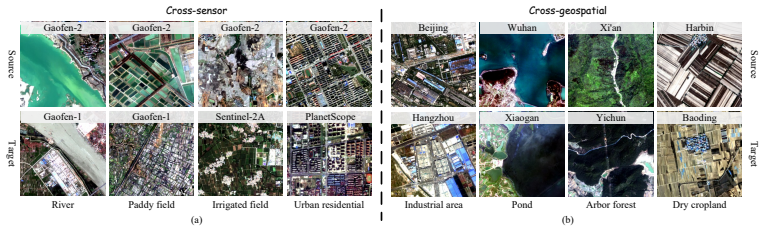
The authors build a cross-sensor benchmark from GF-2 source images with GF-1, PlanetScope and Sentinel-2 targets, and a cross-geospatial benchmark from GF-2 images split by city. They report that Land-MoE beats existing domain generalization methods, with the largest gains on cross-sensor transfer (about 5 to 9 mIoU over the leading baselines) and smaller gains on cross-geospatial and natural RGB tasks (about 1.5 to 2 mIoU). Ablations show each module contributes. The paper also compares Land-MoE across four vision backbones.
Important caveats: all numbers come from single runs with no error bars, optimal hyperparameters such as the number of experts and rank are chosen separately for each task without a described validation protocol, and the paper does not say how four-band multispectral images are fed into a three-channel vision model. Code is not yet public.
Extended reading notes
Core claim
Land-MoE outperforms existing methods by a large margin on multispectral land cover classification under cross-sensor and cross-geospatial shifts, and achieves state-of-the-art results on RGB remote sensing domain generalization. Specifically, it exceeds SET, Rein, and FADA by 8.63%, 5.30%, and 7.79% mIoU on the cross-sensor task, and by 1.59%, 1.99%, and 1.77% mIoU on the cross-geospatial task.
Load-bearing premise
The paper never states how 4-band multispectral images are fed into DINOv2, whose patch embedding expects 3-channel RGB input (Section 4.1 only says images are cropped to 512x512). The entire evaluation depends on some unstated band mapping or band selection. If the near-infrared band is discarded or the mapping is inconsistent across the four sensors, the reported cross-sensor gains could partly reflect this preprocessing choice rather than the adapter design.
Editorial analysis
A structured set of objections, weighed in public.
Referee Report
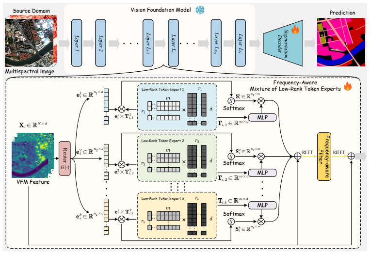
Summary. The paper introduces Land-MoE, a parameter-efficient fine-tuning approach for multispectral land cover classification under domain shift. The method inserts two types of adapters into a frozen vision foundation model (DINOv2 by default): a Mixture of Low-rank Token Experts (MoLTE) that routes each token to a learnable low-rank token expert with different rank, and frequency-aware filters (FAF) that modulate features in the real-FFT domain. The authors evaluate on cross-sensor (GF-2 to GF-1, PlanetScope, Sentinel-2) and cross-geospatial (disjoint Chinese cities) tasks built from the Five-Billion-Pixels dataset, plus RGB cross-scene tasks from LoveDA and Potsdam/Vaihingen. They report consistent improvements over frozen VFM baselines and over SET, Rein, and FADA, with the largest gains on the cross-sensor task and smaller gains on cross-geospatial and RGB tasks.
Significance. If the reported results are reproducible, the paper makes a useful contribution: it is among the first to apply VFM-style parameter-efficient fine-tuning to multispectral land cover classification, and the proposed MoLTE/FAF design is coherent and parameter-efficient. The evaluation covers multiple sensors and geospatial regions, uses the same backbone and decoder for all compared VFM methods, and includes ablations and sensitivity analyses for expert count, rank, token length, learning rate, and batch size. However, the central quantitative claims are currently supported too weakly: the multispectral input preprocessing is not specified, all numbers are single-run with no error bars, and the model configuration is tuned separately for each benchmark. These issues must be addressed before the claims of large-margin state-of-the-art performance can be accepted.
major comments (4)
- [Section 4.1, Appendix A.1] The manuscript never states how 4-band multispectral images (B, G, R, NIR) from GF-2, GF-1, PlanetScope, and Sentinel-2 are mapped to the 3-channel patch embedding of DINOv2. Section 4.1 only says that MSIs are preprocessed by cropping to 512x512, and Appendix A.1 confirms that all four sensors provide four spectral bands, while DINOv2's patch embed is a 3-channel convolution. Because every multispectral experiment (Tables 1-4) depends on this unstated band selection or channel mapping, the central cross-sensor claim cannot be independently checked. Please specify the exact preprocessing (e.g., which three bands are used, or how NIR is folded in), and ideally include an ablation that isolates the contribution of the NIR channel.
- [Tables 1, 2, 10, 11] All accuracy numbers are reported from single runs, with no error bars, number of seeds, or significance tests. The cross-geospatial margins over SET, Rein, and FADA are only 1.59, 1.99, and 1.77 mIoU (Table 2), and the LoveDA margin over Rein is 1.40 mIoU (Table 10); differences of this size can easily be within run-to-run variation. Please provide multiple seeds with standard deviations or an appropriate significance test, or soften the 'large margin' wording for the smaller-gain settings.
- [Appendix B.2, Table 7] The optimal expert count and rank set are selected separately for each benchmark: Ne=3 with rk in {8,16,32} for cross-sensor but Ne=2 with rk in {8,16} for cross-geospatial, and Tables 1 and 2 use these different configurations. If target-task performance influenced this selection, the comparison is not a clean domain-generalization evaluation; at minimum, the selection criterion (e.g., source-domain validation) must be stated, and results for a single fixed configuration should be reported to support the generalization claim.
- [Section 4.2, Related Work] The paper claims state-of-the-art MLCC performance but compares only against DSTC and three VFM-based DG segmentation methods (SET, Rein, FADA). It does not compare with the spectral-shift-specific DG methods it cites, such as FDGNet [60] or frequency-based optimal style mix [33], even though these are directly relevant to the cross-sensor/cross-geospatial setting. Without such comparisons, the 'state-of-the-art' claim is not fully supported.
minor comments (5)
- [Section 3.3, Eq. (11)] The weight lambda of the expert balancing loss is never given a value or ablated; please report it in the implementation details.
- [Section 3.2 and Eq. (8)] The relationship between the two refinement terms is unclear: MoLTE produces Delta-X-bar_i, which is added to X_i to form Z_i for FAF, but Eq. (8) states that the input to the next layer is X_i + Delta-X_i, so the MoLTE adjustment only affects the next layer through the FAF output. Please clarify the data flow and the exact residual structure, and align the notation L_N versus N_L.
- [Table 4] The header uses 'EV A02' while the text and reference list use 'EVA02'; please unify the naming.
- [Tables 1 and 2] Several classes show exactly 0.00% accuracy for all methods (e.g., class C4 in Table 1), which suggests those classes may be absent from the target-domain ground truth; please explain how mAcc and mIoU aggregate classes that do not appear in the target split.
- [Appendix A.3] The cross-geospatial task is described as a subset of 150 GF-2 MSIs, but the number of training and test images in the source and target splits is not stated; please report the exact split sizes and the number of images per target city.
Assumptions & free parameters
free parameters (4)
- N_e and r_k (expert count and per-expert rank) =
N_e=3, r_k in {8,16,32} for cross-sensor; N_e=2, r_k in {8,16} for cross-geospatial
- m (learnable token sequence length per expert) =
100
- lambda (expert balancing loss weight) =
not reported
- k (top-k routing) =
not reported
assumptions (3)
- standard math FFT and inverse FFT on reshaped token grids preserve information needed for segmentation after elementwise filtering
- domain assumption DINOv2, SAM, CLIP, and EVA02 features pretrained on RGB generalize to 4-band multispectral inputs
- domain assumption The 24-class Five-Billion-Pixels label taxonomy is valid across all four sensors
Cite this review
Pith. "Pith review of Generalizable Multispectral Land Cover Classification via Frequency-Aware Mixture of Low-Rank Token Experts." pith.science (2026). https://pith.science/paper/2JFY6T2V
@misc{pith2026250514088,
  author       = {Pith},
  title        = {Pith review of: Generalizable Multispectral Land Cover Classification via Frequency-Aware Mixture of Low-Rank Token Experts},
  year         = {2026},
  howpublished = {\url{https://pith.science/paper/2JFY6T2V}},
  note         = {Machine review of arXiv:2505.14088}
}
read the original abstract
We introduce Land-MoE, a novel approach for multispectral land cover classification (MLCC). Spectral shift, which emerges from disparities in sensors and geospatial conditions, poses a significant challenge in this domain. Existing methods predominantly rely on domain adaptation and generalization strategies, often utilizing small-scale models that exhibit limited performance. In contrast, Land-MoE addresses these issues by hierarchically inserting a Frequency-aware Mixture of Low-rank Token Experts, to fine-tune Vision Foundation Models (VFMs) in a parameter-efficient manner. Specifically, Land-MoE comprises two key modules: the mixture of low-rank token experts (MoLTE) and frequency-aware filters (FAF). MoLTE leverages rank-differentiated tokens to generate diverse feature adjustments for individual instances within multispectral images. By dynamically combining learnable low-rank token experts of varying ranks, it enhances the robustness against spectral shifts. Meanwhile, FAF conducts frequency-domain modulation on the refined features. This process enables the model to effectively capture frequency band information that is strongly correlated with semantic essence, while simultaneously suppressing frequency noise irrelevant to the task. Comprehensive experiments on MLCC tasks involving cross-sensor and cross-geospatial setups demonstrate that Land-MoE outperforms existing methods by a large margin. Additionally, the proposed approach has also achieved state-of-the-art performance in domain generalization semantic segmentation tasks of RGB remote sensing images.
Figures

Figures from the paper (5 more)


Reference graph
Works this paper leans on
-
[60]
B. Qin, S. Feng, C. Zhao, B. Xi, W. Li, and R. Tao. Fdgnet: Frequency disentanglement and data geometry for domain generalization in cross-scene hyperspectral image classification. IEEE Transactions on Neural Networks and Learning Systems, pages 1–14, 2024
work page 2024
- [33]
-
[1]
Anand and C
A. Anand and C. Deb. The potential of remote sensing and gis in urban building energy modelling. Energy and Built Environment, 5(6):957–969, 2024
2024
-
[2]
Awais, M
M. Awais, M. Naseer, S. Khan, R. M. Anwer, H. Cholakkal, M. Shah, M.-H. Yang, and F. S. Khan. Foundation models defining a new era in vision: A survey and outlook. IEEE Transactions on Pattern Analysis and Machine Intelligence, 47(4):2245–2264, 2025
2025
-
[3]
S. Bai, M. Zhang, W. Zhou, S. Huang, Z. Luan, D. Wang, and B. Chen. Prompt-based distribu- tion alignment for unsupervised domain adaptation. In Proceedings of the AAAI conference on artificial intelligence, volume 38, pages 729–737, 2024
2024
-
[4]
Q. Bi, J. Yi, H. Zheng, H. Zhan, Y . Huang, W. Ji, Y . Li, and Y . Zheng. Learning frequency- adapted vision foundation model for domain generalized semantic segmentation. Advances in Neural Information Processing Systems, 37:94047–94072, 2024
work page 2024
-
[5]
C. Broni-Bediako, J. Xia, and N. Yokoya. Unsupervised domain adaptation architecture search with self-training for land cover mapping. In Proceedings of the IEEE/CVF Conference on Computer Vision and Pattern Recognition, pages 543–553, 2024
work page 2024
-
[6]
M. Cai, B. Xi, J. Li, S. Feng, Y . Li, Z. Li, and J. Chanussot. Mind the gap: Multilevel unsupervised domain adaptation for cross-scene hyperspectral image classification. IEEE Transactions on Geoscience and Remote Sensing, 62:1–14, 2024
work page 2024
Show all 83 references
-
[7]
Chattopadhyay, K
P. Chattopadhyay, K. Sarangmath, V . Vijaykumar, and J. Hoffman. Pasta: Proportional amplitude spectrum training augmentation for syn-to-real domain generalization. In Proceedings of the IEEE/CVF international conference on computer vision, pages 19288–19300, 2023
2023
-
[8]
G. Chen, Y . Zhou, J. A. V oogt, and E. C. Stokes. Remote sensing of diverse urban environments: From the single city to multiple cities. Remote Sensing of Environment, 305:114108, 2024
2024
-
[9]
H. Chen, R. Tao, H. Zhang, Y . Wang, X. Li, W. Ye, J. Wang, G. Hu, and M. Savvides. Conv- adapter: Exploring parameter efficient transfer learning for convnets. In Proceedings of the IEEE/CVF Conference on Computer Vision and Pattern Recognition, pages 1551–1561, 2024
2024
-
[10]
J. Chen, Z. Gao, X. Wu, and J. Luo. Meta-causal learning for single domain generalization. In 2023 IEEE/CVF Conference on Computer Vision and Pattern Recognition (CVPR), pages 7683–7692, 2023
2023
-
[11]
J. Chen, J. Zhu, P. He, Y . Guo, L. Hong, Y . Yang, M. Deng, and G. Sun. Unsupervised domain adaptation for building extraction of high-resolution remote sensing imagery based on decoupling style and semantic features. IEEE Transactions on Geoscience and Remote Sensing, 62:1–17, 2024
2024
-
[12]
S. Chen, C. Ge, Z. Tong, J. Wang, Y . Song, J. Wang, and P. Luo. Adaptformer: Adapting vision transformers for scalable visual recognition. Advances in Neural Information Processing Systems, 35:16664–16678, 2022
2022
-
[13]
X. Chen, L. Gao, M. Zhang, C. Chen, and S. Yan. Spectral–spatial adversarial multidomain synthesis network for cross-scene hyperspectral image classification. IEEE Transactions on Geoscience and Remote Sensing, 62:1–16, 2024
2024
-
[14]
Z. Chen, W. Wang, Z. Zhao, F. Su, A. Men, and H. Meng. Practicaldg: Perturbation distillation on vision-language models for hybrid domain generalization. In Proceedings of the IEEE/CVF Conference on Computer Vision and Pattern Recognition, pages 23501–23511, 2024
2024
-
[15]
Cheng, I
B. Cheng, I. Misra, A. G. Schwing, A. Kirillov, and R. Girdhar. Masked-attention mask transformer for universal image segmentation. In Proceedings of the IEEE/CVF conference on computer vision and pattern recognition, pages 1290–1299, 2022
2022
-
[16]
Z. Chi, L. Dong, S. Huang, D. Dai, S. Ma, B. Patra, S. Singhal, P. Bajaj, X. Song, X.-L. Mao, et al. On the representation collapse of sparse mixture of experts. Advances in Neural Information Processing Systems, 35:34600–34613, 2022. 10
2022
-
[17]
X. Deng, Y . Zhu, Y . Tian, and S. Newsam. Scale aware adaptation for land-cover classification in remote sensing imagery. In Proceedings of the IEEE/CVF Winter Conference on Applications of Computer Vision, pages 2160–2169, 2021
2021
-
[18]
Y . Ding, L. Wang, B. Liang, S. Liang, Y . Wang, and F. Chen. Domain generalization by learning and removing domain-specific features. Advances in Neural Information Processing Systems, 35:24226–24239, 2022
2022
-
[19]
Dionelis, F
N. Dionelis, F. Pro, L. Maiano, I. Amerini, and B. Le Saux. Learning from unlabelled data with transformers: Domain adaptation for semantic segmentation of high resolution aerial images. In IGARSS 2024-2024 IEEE International Geoscience and Remote Sensing Symposium, pages 8167...
2024
-
[20]
H. Dong, I. Nejjar, H. Sun, E. Chatzi, and O. Fink. Simmmdg: A simple and effective framework for multi-modal domain generalization. Advances in Neural Information Processing Systems, 36:78674–78695, 2023
2023
-
[21]
R. Dong, L. Mou, M. Chen, W. Li, X.-Y . Tong, S. Yuan, L. Zhang, J. Zheng, X. X. Zhu, and H. Fu. Large-scale land cover mapping with fine-grained classes via class-aware semi- supervised semantic segmentation. In 2023 IEEE/CVF International Conference on Computer Vision (ICCV)...
2023
-
[22]
A. M. Eldosouky, M. Eleraki, A. Mansour, S. A. Saada, and S. Zamzam. Geological controls of mineralization occurrences in the egyptian eastern desert using advanced integration of remote sensing and magnetic data. Scientific Reports, 14(1):16700, 2024
2024
-
[23]
K. Fang, J. Song, L. Gao, P. Zeng, Z.-Q. Cheng, X. Li, and H. T. Shen. Pros: Prompting-to- simulate generalized knowledge for universal cross-domain retrieval. In Proceedings of the IEEE/CVF Conference on Computer Vision and Pattern Recognition, pages 17292–17301, 2024
2024
-
[24]
Y . Fang, Q. Sun, X. Wang, T. Huang, X. Wang, and Y . Cao. Eva-02: A visual representation for neon genesis. Image and Vision Computing, 149:105171, 2024
2024
-
[25]
J. Feng, T. Zhang, J. Zhang, R. Shang, W. Dong, G. Shi, and L. Jiao. S4dl: Shift-sensitive spatial–spectral disentangling learning for hyperspectral image unsupervised domain adaptation. IEEE Transactions on Neural Networks and Learning Systems, pages 1–15, 2025
2025
-
[26]
J. Gao, X. Ji, G. Chen, Y . Huang, and F. Ye. Pseudo-class distribution guided multi-view unsupervised domain adaptation for hyperspectral image classification. International Journal of Applied Earth Observation and Geoinformation, 136:104356, 2025
2025
-
[27]
J. Guo, L. Qi, Y . Shi, and Y . Gao. Seta: Semantic-aware edge-guided token augmentation for domain generalization. IEEE Transactions on Image Processing, 33:5622–5636, 2024
2024
-
[28]
J. Guo, L. Qi, Y . Shi, and Y . Gao. Start: A generalized state space model with saliency-driven token-aware transformation. arXiv preprint arXiv:2410.16020, 2024
2024 arXiv
-
[29]
Hafner, Y
S. Hafner, Y . Ban, and A. Nascetti. Unsupervised domain adaptation for global urban extraction using sentinel-1 sar and sentinel-2 msi data. Remote Sensing of Environment, 280:113192, 2022
2022
-
[30]
M. A. E.-R. Hegab. Mineral exploration and environmental impact assessment in the jabal hamadat area, central eastern desert, egypt, using remote sensing and airborne radiometric data. Scientific Reports, 14(1):21986, 2024
2024
-
[31]
Hoyer, D
L. Hoyer, D. Dai, H. Wang, and L. Van Gool. Mic: Masked image consistency for context- enhanced domain adaptation. In Proceedings of the IEEE/CVF conference on computer vision and pattern recognition, pages 11721–11732, 2023
2023
-
[32]
Huang, H
Z. Huang, H. Wang, J. Zhao, and N. Zheng. idag: Invariant dag searching for domain general- ization. In Proceedings of the IEEE/CVF International Conference on Computer Vision, pages 19169–19179, 2023
2023
-
[34]
R. A. Jacobs, M. I. Jordan, S. J. Nowlan, and G. E. Hinton. Adaptive mixtures of local experts. Neural computation, 3:79–87, 1991
1991
-
[35]
M. Jia, L. Tang, B.-C. Chen, C. Cardie, S. Belongie, B. Hariharan, and S.-N. Lim. Visual prompt tuning. In European conference on computer vision, pages 709–727. Springer, 2022
2022
-
[36]
Jie, Z.-H
S. Jie, Z.-H. Deng, S. Chen, and Z. Jin. Convolutional bypasses are better vision transformer adapters. In ECAI 2024, pages 202–209. IOS Press, 2024
2024
-
[37]
J. M. Jurado, A. López, L. Pádua, and J. J. Sousa. Remote sensing image fusion on 3d scenarios: A review of applications for agriculture and forestry. International journal of applied earth observation and geoinformation, 112:102856, 2022
2022
-
[38]
Kirillov, E
A. Kirillov, E. Mintun, N. Ravi, H. Mao, C. Rolland, L. Gustafson, T. Xiao, S. Whitehead, A. C. Berg, W.-Y . Lo, et al. Segment anything. InProceedings of the IEEE/CVF international conference on computer vision, pages 4015–4026, 2023
2023
-
[39]
G. Kodl, R. Streeter, N. Cutler, and T. Bolch. Arctic tundra shrubification can obscure increasing levels of soil erosion in ndvi assessments of land cover derived from satellite imagery. Remote Sensing of Environment, 301:113935, 2024
2024
-
[40]
C. Kong, A. Luo, P. Bao, Y . Yu, H. Li, Z. Zheng, S. Wang, and A. C. Kot. Moe-ffd: Mix- ture of experts for generalized and parameter-efficient face forgery detection. arXiv preprint arXiv:2404.08452, 2024
2024 arXiv
-
[41]
H. Lang, D. Sontag, and A. Vijayaraghavan. Theoretical analysis of weak-to-strong generaliza- tion. Advances in neural information processing systems, 37:46837–46880, 2024
2024
-
[42]
G. Lee, W. Jang, J. Kim, J. Jung, and S. Kim. Domain generalization using large pretrained models with mixture-of-adapters. In 2025 IEEE/CVF Winter Conference on Applications of Computer Vision (WACV), pages 8259–8269. IEEE, 2025
2025
-
[43]
P. Lei, J. Yi, S. Li, Y . Li, and H. Lin. Agricultural surface water extraction in environmental remote sensing: A novel semantic segmentation model emphasizing contextual information enhancement and foreground detail attention. Neurocomputing, 617:129110, 2025
2025
-
[44]
B. Li, Y . Shen, J. Yang, Y . Wang, J. Ren, T. Che, J. Zhang, and Z. Liu. Sparse mixture-of-experts are domain generalizable learners. arXiv preprint arXiv:2206.04046, 2022
2022 arXiv
-
[45]
C. Li, F. Li, C. Liu, Z. Tang, S. Fu, M. Lin, X. Lv, S. Liu, and Y . Liu. Deep learning-based geological map generation using geological routes. Remote Sensing of Environment , 309: 114214, 2024
2024
-
[46]
H. Li, R. Zhang, H. Yao, X. Zhang, Y . Hao, X. Song, X. Li, Y . Zhao, Y . Chen, and L. Li. Da-ada: Learning domain-aware adapter for domain adaptive object detection. Advances in Neural Information Processing Systems, 37:103574–103598, 2024
2024
-
[47]
L. Li, K. Gao, J. Cao, Z. Huang, Y . Weng, X. Mi, Z. Yu, X. Li, and B. Xia. Progressive domain expansion network for single domain generalization. In Proceedings of the IEEE/CVF conference on computer vision and pattern recognition, pages 224–233, 2021
2021
-
[48]
S. Li, L. Sun, and Q. Li. Clip-reid: exploiting vision-language model for image re-identification without concrete text labels. In Proceedings of the AAAI conference on artificial intelligence, volume 37, pages 1405–1413, 2023
2023
-
[49]
Liang, W
C. Liang, W. Li, Y . Dong, and W. Fu. Single domain generalization method for remote sensing image segmentation via category consistency on domain randomization. IEEE Transactions on Geoscience and Remote Sensing, 62:1–16, 2024
2024
-
[50]
Lin and J
Y . Lin and J. Guo. Fuzzy geospatial objects- based wetland remote sensing image classification: A case study of tianjin binhai new area. International Journal of Applied Earth Observation and Geoinformation, 132:104051, 2024. 12
2024
-
[51]
P. Liu, T. Xu, J. Wang, H. Chen, H. Bai, and J. Li. Dual-stage hyperspectral image classification model with spectral supertoken. In European Conference on Computer Vision, pages 368–386. Springer, 2024
2024
-
[52]
Y . Ma, S. Chen, S. Ermon, and D. B. Lobell. Transfer learning in environmental remote sensing. Remote Sensing of Environment, 301:113924, 2024
2024
-
[53]
Y . Ni, S. Zhang, and P. Koniusz. Pace: Marrying generalization in parameter-efficient fine- tuning with consistency regularization. Advances in Neural Information Processing Systems, 37:61238–61266, 2024
2024
-
[54]
X. Ning, H. Zhang, R. Zhang, and X. Huang. Multi-stage progressive change detection on high resolution remote sensing imagery. ISPRS Journal of Photogrammetry and Remote Sensing, 207:231–244, 2024
2024
-
[55]
Noman, M
M. Noman, M. Naseer, H. Cholakkal, R. M. Anwer, S. Khan, and F. S. Khan. Rethinking transformers pre-training for multi-spectral satellite imagery. In Proceedings of the IEEE/CVF Conference on Computer Vision and Pattern Recognition, pages 27811–27819, 2024
2024
-
[56]
Oquab, T
M. Oquab, T. Darcet, T. Moutakanni, H. V o, M. Szafraniec, V . Khalidov, P. Fernandez, D. Haziza, F. Massa, A. El-Nouby, et al. Dinov2: Learning robust visual features without supervision. arXiv preprint arXiv:2304.07193, 2023
2023 arXiv
-
[57]
J. Pan, Z. Lin, X. Zhu, J. Shao, and H. Li. St-adapter: Parameter-efficient image-to-video transfer learning. Advances in Neural Information Processing Systems, 35:26462–26477, 2022
2022
-
[58]
J. Pan, Z. Wang, T. Chen, K. Jia, and A. Plaza. Spatial and temporal change monitoring of wetland urban ecology based on a remote sensing ecological index considering full elements. IEEE Journal of Selected Topics in Applied Earth Observations and Remote Sensing, 2024
2024
-
[59]
F. Qiao, L. Zhao, and X. Peng. Learning to learn single domain generalization. In 2020 IEEE/CVF Conference on Computer Vision and Pattern Recognition (CVPR), pages 12553– 12562, 2020
2020
-
[61]
R. Rad. Vision transformer for multispectral satellite imagery: Advancing landcover classifica- tion. In Proceedings of the IEEE/CVF Winter Conference on Applications of Computer Vision, pages 8176–8183, 2024
2024
-
[62]
Radford, J
A. Radford, J. W. Kim, C. Hallacy, A. Ramesh, G. Goh, S. Agarwal, G. Sastry, A. Askell, P. Mishkin, J. Clark, et al. Learning transferable visual models from natural language supervision. In International conference on machine learning, pages 8748–8763. PmLR, 2021
2021
-
[63]
Runwal, T
B. Runwal, T. Pedapati, and P.-Y . Chen. From peft to deft: Parameter efficient finetuning for reducing activation density in transformers. In Proceedings of the AAAI Conference on Artificial Intelligence, volume 39, pages 20218–20227, 2025
2025
-
[64]
J. Song, H. Chen, and N. Yokoya. Syntheworld: A large-scale synthetic dataset for land cover mapping and building change detection. In Proceedings of the IEEE/CVF Winter Conference on Applications of Computer Vision, pages 8287–8296, 2024
2024
-
[65]
J. Su, Q. Fan, W. Pei, G. Lu, and F. Chen. Domain-rectifying adapter for cross-domain few-shot segmentation. In Proceedings of the IEEE/CVF Conference on Computer Vision and Pattern Recognition, pages 24036–24045, 2024
2024
-
[66]
W. Sun, D. Chen, Z. Li, S. Li, S. Cheng, X. Niu, Y . Cai, Z. Shi, C. Wu, G. Yang, et al. Monitoring wetland plant diversity from space: Progress and perspective. International Journal of Applied Earth Observation and Geoinformation, 130:103943, 2024
2024
-
[67]
Tong, G.-S
X.-Y . Tong, G.-S. Xia, Q. Lu, H. Shen, S. Li, S. You, and L. Zhang. Land-cover classification with high-resolution remote sensing images using transferable deep models. Remote Sensing of Environment, 237:111322, 2020. 13
2020
-
[68]
Tong, G.-S
X.-Y . Tong, G.-S. Xia, and X. X. Zhu. Enabling country-scale land cover mapping with meter- resolution satellite imagery. ISPRS Journal of Photogrammetry and Remote Sensing , 196: 178–196, 2023
2023
-
[69]
C. Wan, X. Shen, Y . Zhang, Z. Yin, X. Tian, F. Gao, J. Huang, and X.-S. Hua. Meta convolutional neural networks for single domain generalization. In Proceedings of the IEEE/CVF Conference on Computer Vision and Pattern Recognition, pages 4682–4691, 2022
2022
-
[70]
J. Wang, Z. Zheng, A. Ma, X. Lu, and Y . Zhong. Loveda: A remote sensing land-cover dataset for domain adaptive semantic segmentation. arXiv preprint arXiv:2110.08733, 2021
2021 arXiv
-
[71]
Y . Wang, L. Feng, Z. Zhang, and F. Tian. An unsupervised domain adaptation deep learning method for spatial and temporal transferable crop type mapping using sentinel-2 imagery.ISPRS Journal of Photogrammetry and Remote Sensing, 199:102–117, 2023
2023
-
[72]
Z. Wang, Y . Luo, R. Qiu, Z. Huang, and M. Baktashmotlagh. Learning to diversify for single domain generalization. In Proceedings of the IEEE/CVF international conference on computer vision, pages 834–843, 2021
2021
-
[73]
Z. Wei, L. Chen, Y . Jin, X. Ma, T. Liu, P. Ling, B. Wang, H. Chen, and J. Zheng. Stronger fewer & superior: Harnessing vision foundation models for domain generalized semantic segmentation. In Proceedings of the IEEE/CVF conference on computer vision and pattern recognition, ...
2024
-
[74]
Z. Xiao, J. Shen, M. M. Derakhshani, S. Liao, and C. G. Snoek. Any-shift prompting for generalization over distributions. In Proceedings of the IEEE/CVF Conference on Computer Vision and Pattern Recognition, pages 13849–13860, 2024
2024
-
[75]
Y . Xin, S. Luo, H. Zhou, J. Du, X. Liu, Y . Fan, Q. Li, and Y . Du. Parameter-efficient fine-tuning for pre-trained vision models: A survey. arXiv preprint arXiv:2402.02242, 2024
2024
-
[76]
Q. Xu, L. Yao, Z. Jiang, G. Jiang, W. Chu, W. Han, W. Zhang, C. Wang, and Y . Tai. Dirl: Domain- invariant representation learning for generalizable semantic segmentation. In Proceedings of the AAAI conference on artificial intelligence, volume 36, pages 2884–2892, 2022
2022
-
[77]
Z. Yang, D. Wu, C. Wu, Z. Lin, J. Gu, and W. Wang. A pedestrian is worth one prompt: Towards language guidance person re-identification. In Proceedings of the IEEE/CVF Conference on Computer Vision and Pattern Recognition, pages 17343–17353, 2024
2024
-
[78]
H. Yao, R. Zhang, and C. Xu. Visual-language prompt tuning with knowledge-guided context optimization. In Proceedings of the IEEE/CVF conference on computer vision and pattern recognition, pages 6757–6767, 2023
2023
-
[79]
C. Ye, Y . Zhuge, and P. Zhang. Towards open-vocabulary remote sensing image semantic segmentation. In Proceedings of the AAAI Conference on Artificial Intelligence, volume 39, pages 9436–9444, 2025
2025
-
[80]
J. Yi, Q. Bi, H. Zheng, H. Zhan, W. Ji, Y . Huang, Y . Li, and Y . Zheng. Learning spectral- decomposited tokens for domain generalized semantic segmentation. In Proceedings of the 32nd ACM International Conference on Multimedia, pages 8159–8168, 2024
2024
-
[81]
X. Yu, S. Yoo, and Y . Lin. Clipceil: Domain generalization through clip via channel refinement and image-text alignment. Advances in Neural Information Processing Systems, 37:4267–4294, 2024
2024
-
[82]
Z. Yue, Q. Sun, and H. Zhang. Make the u in uda matter: Invariant consistency learning for unsupervised domain adaptation. Advances in Neural Information Processing Systems , 36: 26991–27004, 2023
2023
-
[83]
Q. Zhu, Z. Li, T. Song, L. Yao, Q. Guan, and L. Zhang. Unrestricted region and scale: Deep self-supervised building mapping framework across different cities from five continents. ISPRS Journal of Photogrammetry and Remote Sensing, 209:344–367, 2024. 14 A Details of the Constr...
2024
Reviewed August 7, 2026 · model on record in the stance chip above.
Discussion (0). Sign in to comment.