REVIEW 4 major objections 5 minor 20 references
Adaptive Per-Tree Canopy Volume Estimation Using Mobile LiDAR in Structured and Unstructured Orchards
T0 review · 4 major / 5 minor · reviewed 2026-08-07 · deepseek-v4-flash
Pith's one-line read Per-tree canopy volume can be estimated in real time from a robot's routine mobile LiDAR scans, provided segmentation adapts to orchard density — 93% success in pistachio, 80% in almond after a spectral-clustering split step.
desk verdict The segmentation idea is reasonable, but Table I's volume numbers don't add up, so the paper's central claim is unsupported as printed. read the letter →
The pith
A machine-rendered reading of the paper's core claim, the machinery that carries it, and where it could break.
The reading
What carries the argument
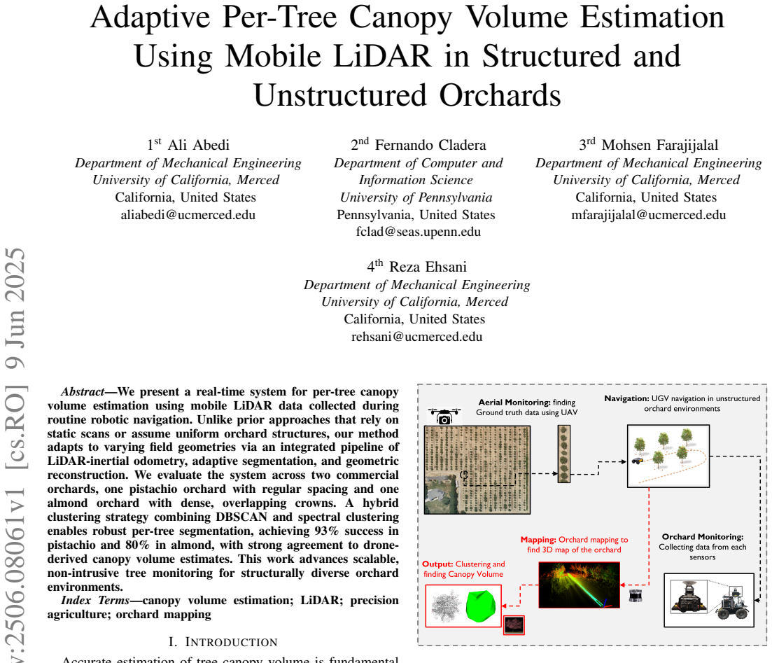
The load-bearing mechanism is a two-stage clustering cascade. First DBSCAN (ε=0.8 m, min points 1300) produces initial clusters, with voxel downsampling and RANSAC ground removal as preprocessing. Second, any cluster above 45,000 points is treated as a merged tree group; spectral clustering on a k-nearest-neighbor graph (k=10) embeds the points and k-means splits them into subclusters whose count is estimated from cluster size divided by the maximum allowed size. Volumes are then computed by Convex Hull (upper bound) and Alpha Shape with α=0.9 m, which captures concave canopy shape. The identity that carries the argument is that overly large density clusters correspond to overlapping crowns, and that graph connectivity reveals the individual trees within them.
What would settle it
Measure the same pistachio trees with a static, high-resolution terrestrial LiDAR scanner that sees the full crown, and check whether the mobile-LiDAR Alpha Shape volumes match the drone-sphere volumes within the errors reported in Table I; alternatively, run the almond two-stage pipeline on the pistachio rows and see if the added spectral splitting degrades the 93% segmentation, which would show the 46% to 80% gain is not a generalizable result.
Extended reading notes
Core claim
The central discovery is that the obstacle to per-tree canopy volume from mobile LiDAR is not geometry reconstruction but segmentation: in a dense almond orchard the same DBSCAN parameters that work in a uniform pistachio orchard group multiple interwoven trees into one cluster, failing on 54% of trees. Adding a graph-based spectral clustering refinement that splits any cluster larger than 45,000 points into subclusters on a k-nearest-neighbor connectivity graph recovers correct individual crowns in 80% of cases. With per-tree clusters in hand, the paper shows that Alpha Shape reconstruction (α=0.9 m) tracks drone-derived spherical volume estimates for pistachio trees with the errors shown in Table I, while Convex Hull systematically overestimates. The authors present this as evidence that adaptive, geometry-aware segmentation is the missing piece for scalable per-tree canopy monitoring.
Load-bearing premise
The validation assumes that drone photogrammetry turned into spherical volumes from canopy diameters is accurate ground truth for canopy volume; the paper itself notes this only holds for roughly symmetric crowns (Section III-A), so the volume-error claims rest on that simplification.
Editorial extensions
If this is right
- During a normal robot pass at up to about 1.5 m/s, every tree in a row can receive a label and a volume estimate, so canopy monitoring requires no stationary scanning or offline processing.
- The same DBSCAN-plus-spectral pipeline should apply to other dense plantings with overlapping canopies, such as olives or vineyards, without retuning.
- With per-tree volumes and sequential row labeling, repeated passes enable growth, pruning, and health tracking across the season.
- Volume estimates from Alpha Shape, not Convex Hull, should be used when the goal is fidelity to concave canopy shape.
Reading between the lines
- The paper limits quantitative volume validation to the pistachio orchard and admits the drone orthomosaic-to-sphere ground truth is idealized for symmetric crowns; for asymmetric almond canopies the reported accuracy should be treated as untested until a true 3D reference is used.
- The 20% of almond trees still mis-segmented could skew per-tree averages in yield or biomass models; a natural extension is measuring how much the volume distribution changes when remaining merges are corrected manually.
- The heuristic of splitting clusters by a point-count threshold on a k-NN graph is a transferable recipe: any LiDAR instance-segmentation problem with touching objects (street trees, shrubs, stacked material) could adopt the same over-cluster refinement.
Editorial analysis
A structured set of objections, weighed in public.
Referee Report
Summary. The manuscript proposes a mobile LiDAR-based pipeline for per-tree canopy volume estimation in orchards, combining LiDAR-inertial odometry, RANSAC ground removal, DBSCAN clustering (with an additional spectral clustering refinement for dense almond orchards), and geometric volume reconstruction via Convex Hull and Alpha Shape. The system is evaluated in two commercial orchards: a pistachio orchard where DBSCAN alone is reported to achieve 93% segmentation success, and an almond orchard where a hybrid DBSCAN-plus-spectral strategy is reported to raise segmentation success from 46% to 80%. The abstract claims "strong agreement" between LiDAR-derived volumes and drone-derived ground truth, with Table I presented as the supporting per-tree evidence. The paper also describes tree labeling, traversal speed, and discusses limitations and future work.
Significance. If the claims were substantiated, the work would provide a practically valuable contribution: real-time, per-tree canopy volume estimation from a mobile platform during routine navigation, without static scans, and with adaptation to structurally diverse orchards. The system targets an important precision-agriculture need (scalable canopy monitoring for yield and harvest optimization), and the combination of DBSCAN with spectral clustering for overlapping canopies is a sensible and potentially reusable idea. The paper also makes its intended scope clear by honestly acknowledging that almond volume validation was not performed. However, the actual quantitative evidence for the central volume-accuracy claim is internally inconsistent, and the segmentation parameters are selected after observing the same data on which success rates are measured; these issues currently leave the core claims unverified.
major comments (4)
- [Table I] Table I contains multiple internally inconsistent error values that cannot be explained by rounding. For example, Tree 9 lists ground truth 31.78 m^3, convex hull 33.83 m^3, and convex hull error 31.87%, whereas the true error is (33.83-31.78)/31.78 = 6.4%; the same row lists alpha shape volume 6.44 m^3 with error 0.29%, whereas the true error is about 79.7%. Tree 13 lists ground truth 9.53 m^3, convex hull 11.38 m^3, and convex hull error 10.89%, but the true error is 19.4%, and its alpha shape volume of 19.48 m^3 is labeled 14.35% when the true error is 104.4%. Similar mismatches appear in rows 8, 10, 11, and 15. Because Table I is the only per-tree evidence for the abstract's claim of "strong agreement to drone derived canopy volume estimates," and because no code, data, or derivation is provided to reconstruct the intended columns, the central volume-accuracy claim is not supported by the presented evidence.
- [Section II-C and Section III-B] The segmentation parameters are selected after observing the data, and success rates are measured on the same data. Section II-C defines epsilon = 0.8 m, minPts = 1300, the 45,000-point cluster threshold, and k = 10 for spectral clustering as fixed values, while Section III-B reports that plain DBSCAN gives 46% success and the enhanced method gives 80% success in the almond orchard, with no held-out validation or cross-validation. Because the thresholds appear to be tuned to the specific orchards rather than derived from a general rule or an independent training set, the reported percentages may reflect overfitting and the claimed generalizability is not established. A concrete test would be to fix the pipeline parameters on one orchard and then evaluate on a second orchard without further tuning, or to report parameter sensitivity analysis.
- [Section III-A] The ground truth for canopy volume is based on drone photogrammetry processed into an orthomosaic, from which canopy diameters are converted to spherical volumes. Section III-A concedes this approximation is "idealized" and valid only when crowns are approximately symmetrical. Since many of the reported trees (e.g., Trees 8, 9, 13, 15) have volumes or errors that appear anomalous, and since no almond volume validation is presented at all, the numerical accuracy of the LiDAR volume estimates against a truly independent and physically meaningful reference remains unverified. The spherical assumption is a load-bearing limitation because the stated objective is per-tree canopy volume estimation, and the only numerical evidence for that objective depends on a model that is known to be inaccurate for non-symmetrical crowns.
- [General (Section III)] The paper does not report any uncertainty quantification, repeatability analysis, or comparison with a direct manual or destructive measurement of canopy volume. Given that the stated contribution is quantitative volume estimation, the lack of any error bars, standard deviations, or repeated traversals leaves the reader unable to judge whether the reported "errors" are within acceptable agronomic tolerances. This is particularly concerning because the same mobile platform was used in both orchards, yet no information is given about how many runs were performed, how tree labels were matched across runs, or how partial scans and occlusion affected the completeness of individual tree point clouds.
minor comments (5)
- [Title and Abstract] The title contains a typo: "Canopy V olume" should be "Canopy Volume."
- [Section II-E] The alpha shape radius is stated as alpha = 0.9 m without any sensitivity analysis or justification; a sentence explaining how this value was chosen (e.g., relative to point spacing or canopy size) would improve reproducibility.
- [Section II-F] The traversal speed paragraph reports times "around 50 seconds" and "around 110 seconds" but does not state the row lengths or the number of trees per row, making the speed claim difficult to interpret.
- [Section III-A] Table I reports "seventeen representative trees" but does not state how these were selected or whether they are consecutive trees in a row or a random sample; this selection bias could affect the reported error statistics.
- [References] Reference [17] appears to be an unrelated arXiv preprint on air-ground collaboration and language-specified missions; if it is cited as a related LiDAR or agricultural application, the citation is inaccurate or at least needs clarification.
Circularity Check
No circular derivation chain; validation concerns in Table I are non-circular.
full rationale
The paper's pipeline is a sequence of independently specified operations: LiDAR-inertial mapping, RANSAC ground/trunk removal, voxel downsampling, DBSCAN with stated parameters, spectral refinement for almond, and Convex Hull / Alpha Shape volume reconstruction. None of these stages is defined in terms of the reported outputs: the 93% and 80% segmentation success rates are measured against independently identified tree canopies, and the volume estimates are compared against drone-photogrammetry spherical volumes rather than being fitted to them. The pipeline configuration is orchard-specific and may be in-sample, but the paper never presents the tuning as a prediction or derives its success from the parameters by construction. The manuscript contains two non-circular validity weaknesses that the reader should weigh separately: (1) Section III-A concedes that the drone-derived ground truth is an idealized spherical approximation valid only for approximately symmetrical crowns; (2) Table I's printed error percentages do not match the listed volumes (e.g., row 9: ground truth 31.78 m^3, Alpha Shape 6.44 m^3, yet the printed Alpha Shape error is 0.29% rather than about 79.7%). These undermine the strength of the 'strong agreement' claim, but they are not circularity because no claimed output reduces by definition to a fitted input or to a self-citation chain. No load-bearing self-citation, uniqueness theorem, or ansatz-smuggling citation is invoked. The derivation chain is self-contained, independent of external benchmarks, and therefore receives a circularity score of 0.
Assumptions & free parameters
free parameters (6)
- DBSCAN epsilon =
0.8 m
- DBSCAN minPts =
1300 points
- Voxel downsample resolution =
0.1 m
- Almond cluster size threshold =
45,000 points
- Spectral clustering k (kNN) =
10
- Alpha Shape radius alpha =
0.9 m
assumptions (3)
- domain assumption Ground truth canopy volume can be modeled as a sphere using canopy diameter from orthomosaic maps.
- domain assumption Mobile LiDAR scans during a single pass provide sufficient canopy coverage for volume estimation.
- ad hoc to paper Clusters exceeding 45,000 points always represent multiple overlapping trees.
Cite this review
Pith. "Pith review of Adaptive Per-Tree Canopy Volume Estimation Using Mobile LiDAR in Structured and Unstructured Orchards." pith.science (2026). https://pith.science/paper/RC6VIEBT
@misc{pith2026250608061,
  author       = {Pith},
  title        = {Pith review of: Adaptive Per-Tree Canopy Volume Estimation Using Mobile LiDAR in Structured and Unstructured Orchards},
  year         = {2026},
  howpublished = {\url{https://pith.science/paper/RC6VIEBT}},
  note         = {Machine review of arXiv:2506.08061}
}
read the original abstract
We present a real-time system for per-tree canopy volume estimation using mobile LiDAR data collected during routine robotic navigation. Unlike prior approaches that rely on static scans or assume uniform orchard structures, our method adapts to varying field geometries via an integrated pipeline of LiDAR-inertial odometry, adaptive segmentation, and geometric reconstruction. We evaluate the system across two commercial orchards, one pistachio orchard with regular spacing and one almond orchard with dense, overlapping crowns. A hybrid clustering strategy combining DBSCAN and spectral clustering enables robust per-tree segmentation, achieving 93% success in pistachio and 80% in almond, with strong agreement to drone derived canopy volume estimates. This work advances scalable, non-intrusive tree monitoring for structurally diverse orchard environments.
Figures


Reference graph
Works this paper leans on
-
[1]
A study on canopy volume measurement model for fruit tree application based on lidar point cloud,
N. Guo, N. Xu, J. Kang, G. Zhang, Q. Meng, M. Niu, W. Wu, and X. Zhang, “A study on canopy volume measurement model for fruit tree application based on lidar point cloud,”Agriculture, vol. 15, no. 2, p. 130, 2025
work page 2025
-
[2]
Health assessment of plantations based on lidar canopy spatial structure parameters,
P. Meng, H. Wang, S. Qin, X. Li, Z. Song, Y . Wang, Y . Yang, and J. Gao, “Health assessment of plantations based on lidar canopy spatial structure parameters,”International Journal of Digital Earth, vol. 15, no. 1, pp. 712–729, 2022
work page 2022
-
[3]
A comprehensive re- view of lidar applications in crop management for precision agriculture,
S. M. Farhan, J. Yin, Z. Chen, and M. S. Memon, “A comprehensive re- view of lidar applications in crop management for precision agriculture,” Sensors (Basel, Switzerland), vol. 24, no. 16, p. 5409, 2024
work page 2024
-
[4]
Assessing crucial shaking parameters in the mechanical harvesting of nut trees: A review,
F. Mohsen, A. Abedi, M. Cristian, K. Amir, M. Mohammadmehdi, T. Arash, and E. Reza, “Assessing crucial shaking parameters in the mechanical harvesting of nut trees: A review,”Horticulturae, vol. 11, no. 4, p. 392, 2025
work page 2025
-
[5]
F. Aragon-Rodriguez, A. B. Dias, A. Pinheiro, J. Pec ¸a, I. L. D ´ıas, and S. Castro-Garcia, “Assessment of a side-row continuous canopy shaking harvester and its adaptability to the portuguese cobranc ¸osa variety in high-density olive orchards,”Sensors, vol. 23, no. 3, p. 1740, 2023
work page 2023
-
[6]
Data-driven model to improve mechanical harvesters for nut trees,
M. Farajijalal, S. Malek, A. Toudeshki, J. H. Viers, and R. Ehsani, “Data-driven model to improve mechanical harvesters for nut trees,” in2024 ASABE Annual International Meeting. American Society of Agricultural and Biological Engineers, 2024, p. 1
work page 2024
-
[7]
Mechanical harvesting of selected temperate and tropical fruit and nut trees,
L. Afsah-Hejri, T. Homayouni, A. Toudeshki, R. Ehsani, L. Ferguson, and S. Castro-Garc´ıa, “Mechanical harvesting of selected temperate and tropical fruit and nut trees,”Horticultural Reviews, vol. 49, pp. 171–242, 2022
work page 2022
-
[8]
N. K. Verma, D. W. Lamb, N. Reid, and B. Wilson, “Comparison of canopy volume measurements of scattered eucalypt farm trees derived from high spatial resolution imagery and lidar,”Remote Sensing, vol. 8, no. 5, p. 388, 2016
work page 2016
Show all 20 references
-
[9]
Lidar applications in precision agriculture for cultivating crops: A review of recent advances,
G. Rivera, R. Porras, R. Florencia, and J. P. S ´anchez-Sol´ıs, “Lidar applications in precision agriculture for cultivating crops: A review of recent advances,”Computers and electronics in agriculture, vol. 207, p. 107737, 2023
2023
-
[10]
Applications of lidar in agricul- ture and future research directions,
S. Debnath, M. Paul, and T. Debnath, “Applications of lidar in agricul- ture and future research directions,”Journal of Imaging, vol. 9, no. 3, p. 57, 2023
2023
-
[11]
Improving irrigation management of cotton with small unmanned aerial vehicle (uav) in texas high plains,
A. Risal, H. Niu, J. L. Landivar-Scott, M. M. Maeda, C. W. Bednarz, J. Landivar-Bowles, N. Duffield, P. Payton, P. Pal, R. J. Lascanoet al., “Improving irrigation management of cotton with small unmanned aerial vehicle (uav) in texas high plains,”Water, vol. 16, no. 9, p. 1300, 2024
2024
-
[12]
Evaluation of stem rust disease in wheat fields by drone hyperspectral imaging,
J. Abdulridha, A. Min, M. N. Rouse, S. Kianian, V . Isler, and C. Yang, “Evaluation of stem rust disease in wheat fields by drone hyperspectral imaging,”Sensors, vol. 23, no. 8, p. 4154, 2023
2023
-
[13]
Estimating crop seed composition using machine learning from multi- sensory uav data,
K. Dilmurat, V . Sagan, M. Maimaitijiang, S. Moose, and F. B. Fritschi, “Estimating crop seed composition using machine learning from multi- sensory uav data,”Remote Sensing, vol. 14, no. 19, p. 4786, 2022
2022
-
[14]
To what extent can uav photogrammetry replicate uav lidar to determine forest structure? a test in two contrasting tropical forests,
I. M. McNicol, E. T. Mitchard, C. Aquino, A. Burt, H. Carstairs, C. Dassi, A. Modinga Dikongo, and M. I. Disney, “To what extent can uav photogrammetry replicate uav lidar to determine forest structure? a test in two contrasting tropical forests,”Journal of Geophysical Researc...
2021
-
[15]
Mapping canopy heights in dense tropical forests using low-cost uav-derived photogram- metric point clouds and machine learning approaches,
H. Zhang, M. Bauters, P. Boeckx, and K. Van Oost, “Mapping canopy heights in dense tropical forests using low-cost uav-derived photogram- metric point clouds and machine learning approaches,”Remote Sensing, vol. 13, no. 18, p. 3777, 2021
2021
-
[16]
Individual tree canopy parameters estimation using uav-based photogrammetric and lidar point clouds in an urban park,
E. Ghanbari Parmehr and M. Amati, “Individual tree canopy parameters estimation using uav-based photogrammetric and lidar point clouds in an urban park,”Remote Sensing, vol. 13, no. 11, p. 2062, 2021
2021
-
[17]
Air-ground col- laboration for language-specified missions in unknown environments,
F. Cladera, Z. Ravichandran, J. Hughes, V . Murali, C. Nieto-Granda, M. A. Hsieh, G. J. Pappas, C. J. Taylor, and V . Kumar, “Air-ground col- laboration for language-specified missions in unknown environments,” arXiv preprint arXiv:2505.09108, 2025
2025 arXiv
-
[18]
A laser scanner based measurement system for quantification of citrus tree geometric characteristics,
K. Lee and R. Ehsani, “A laser scanner based measurement system for quantification of citrus tree geometric characteristics,”Applied Engineer- ing in Agriculture, vol. 25, no. 5, pp. 777–788, 2009
2009
-
[19]
Obtaining the three- dimensional structure of tree orchards from remote 2d terrestrial lidar scanning,
J. R. Rosell, J. Llorens, R. Sanz, J. Arn ´o, M. Ribes-Dasi, J. Masip, A. Escol`a, F. Camp, F. Solanelles, F. Gr`aciaet al., “Obtaining the three- dimensional structure of tree orchards from remote 2d terrestrial lidar scanning,”Agricultural and F orest Meteorology, vol. 149, ...
2009
-
[20]
As- sessing the performance of an affordable guidance systems for parallel movement in orchards,
M. Maharlooei, A. Toudeshki, R. Van Steenwyk, and R. Ehsani, “As- sessing the performance of an affordable guidance systems for parallel movement in orchards,” in2024 ASABE Annual International Meeting. American Society of Agricultural and Biological Engineers, 2024, p. 1. Acc...
2024
Reviewed August 7, 2026 · model on record in the stance chip above.
Discussion (0). Sign in to comment.