REVIEW 4 major objections 5 minor 14 references
MODS: Multi-source Observations Conditional Diffusion Model for Meteorological State Downscaling
T0 review · 4 major / 5 minor · reviewed 2026-08-07 · deepseek-v4-flash
Pith's one-line read MODS: multi-source satellite and topographic conditioning plus station-guided sampling lowers station-level ERA5 downscaling errors at 6.25 km
desk verdict The headline accuracy numbers are contaminated by label leakage—station guidance and station evaluation use the same data—so the reported gains are not evidence of downscaling skill. read the letter →
The pith
A machine-rendered reading of the paper's core claim, the machinery that carries it, and where it could break.
The reading
What carries the argument
The carrying mechanism is the combination of multi-source cross-attention fusion with guided reverse diffusion. Cross-attention, written as $\mathrm{Softmax}(W_Q(X) \cdot W_K(Y)/\sqrt{d}) \cdot W_V(Y)$ with $Y$ the concatenation of the geostationary, polar-orbiting, and topographic latent embeddings, lets the denoiser weight each observational source by its relevance to the ERA5 target. At sampling time, guidance is applied by updating the estimated clean image $\tilde{x}_0$ with the gradient of $L_{\text{tot}}$, and the optimizable kernel of $f_1$, the convolution that simulates the scale change, is updated as the reverse steps proceed.
What would settle it
Evaluate MODS on a set of stations withheld from both training and sampling guidance, comparing the guided and unguided versions against interpolation baselines on those stations. If the unguided model matches the guided one, or if guided MODS no longer beats bicubic interpolation when it cannot see the evaluation stations, the central claim of station-guided improvement is not supported.
Extended reading notes
Core claim
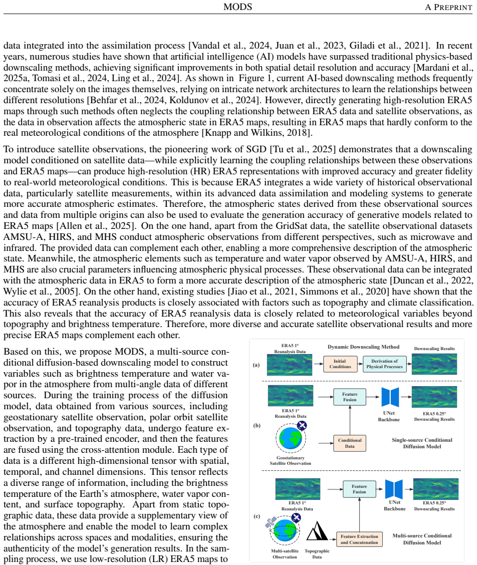
MODS is a conditional diffusion model for ERA5 downscaling in which the conditioning signal is not a single satellite channel but a fused set of sources: GridSat geostationary brightness temperature, AMSU-A, HIRS, and MHS polar-orbiting soundings, and GEBCO topography. Each source is encoded by a separately pre-trained encoder, and the latent embeddings are concatenated and injected into the denoising U-Net (a convolutional encoder-decoder network) through a cross-attention module. During sampling, the model keeps its output consistent with the input via an optimizable convolutional scale-conversion $f_1$, and it steers the reverse process with station observations, giving the total guidance loss $L_{\text{tot}} = \lambda_1 L_1(f_1(\tilde{x}_0), z_l) + \lambda_2 L_2(f_2(f_1(\tilde{x}_0)), f_2(z_r))$. The paper reports that this multi-source conditioning plus multi-guidance yields lower station-level MSE and MAE than interpolation and than the single-source SGD baseline across U10, V10, T2m, and MSL, with the largest gain on 2 m temperature (T2m MSE 155.64 versus 187.69 for SGD).
Load-bearing premise
The load-bearing premise is that the same Weather 5k station observations used to guide the reverse sampling process are an independent yardstick for the reported MSE and MAE, even though the sampler is adjusted toward those station values during generation.
Editorial extensions
If this is right
- Multi-source conditioning outperforms single-source conditioning on all four reported variables, so the diversity of observational channels is the operative improvement, not just the diffusion backbone.
- Station-scale guidance alone yields the best station metrics in the ablation, while combining it with low-resolution map guidance trades some station accuracy for detail preservation.
- The same trained model can be steered at inference time by changing guidance weights, so one model can serve different fidelity-versus-detail requirements.
- Because topography contributes a small but measurable gain, static surface data matters less than atmospheric sounding channels for these variables, which is useful for planning which conditions to add.
- If the reported errors hold, reanalysis downscaling can be observation-driven rather than purely image-to-image, which is relevant for generating local-scale meteorological fields for forecasting and simulation.
Reading between the lines
- The reported gains mix two effects: what the model learns from multi-source conditioning and what the station guidance itself contributes, because the same Weather 5k stations are used both as sampling guidance and as evaluation ground truth; a held-out-station evaluation would separate them, and the paper does not report one.
- Wind-sensitive satellite channels such as scatterometer winds would likely improve U10 and V10; the paper itself notes ASCAT as a natural next condition.
- The optimizable scale-conversion function $f_1$ is not tied to a fixed grid, so the guidance mechanism should transfer to other target resolutions or regional domains without architectural changes.
- The cross-attention fusion recipe is generic: any observation source with a pre-trained encoder could be added as a condition, provided it correlates with the ERA5 variables being downscaled.
Editorial analysis
A structured set of objections, weighed in public.
Referee Report
Summary. The paper proposes MODS, a conditional diffusion model for downscaling ERA5 reanalysis fields using multi-source satellite observations (GridSat, AMSU-A, HIRS, MHS) and topographic data (GEBCO) as conditioning inputs, together with sampling-time guidance from low-resolution ERA5 maps and station-scale meteorological observations. The authors report station-level MSE and MAE on the Weather5k dataset for U10, V10, T2m, and MSL, and claim that MODS outperforms interpolation and existing diffusion-based downscaling baselines. The central evaluation, however, is contaminated: the station observations used as sampling guidance are the same data used as evaluation labels, and the reported configuration labels are internally inconsistent.
Significance. If the reported results were valid, the multi-source conditioning architecture and the flexible guidance formulation would be a useful contribution to station-level meteorological downscaling. The paper also deserves credit for explicitly acknowledging, in Section 5, that wind-relevant satellite data such as ASCAT are absent. However, the headline quantitative claims are not supported by the current evaluation protocol because of label leakage, and the paper does not provide code, data, or uncertainty estimates that would allow the claims to be independently verified. As presented, the contribution is a plausible proposal with an invalid benchmark rather than a demonstrated improvement.
major comments (4)
- [§3.3, Eq. (3), Algorithm 1; Table 2; Table 4] The evaluation is contaminated by label leakage. Equation (3) defines L_total = λ1 L1(f1(˜x0), z_l) + λ2 L2(f2(f1(˜x0)), f2(z_r)), and Algorithm 1 (lines 5–8) uses this loss to update the reverse-sampling mean, with z_r described in the text as station-scale data. Table 2 then evaluates the same variables against Weather5k station values, which are exactly the z_r values used as guidance. The MODS row in Table 2 is numerically identical to the "guided by station-scale data" row in Table 4 (U10 43.43, V10 39.96, T2m 155.64, MSL 371.28), notwithstanding the Table 2 caption claiming multi-guidance; the actual multi-guided row in Table 4 is worse (54.32/40.52/172.04/374.26). Thus the headline numbers come from the configuration with maximal leakage, and no experiment separates guidance stations from evaluation stations or omits station guidance. The reported accuracy gains cannot be attributed to learned downscaling skill.
- [Table 2 vs. Table 4] The configuration labels are internally inconsistent. Table 2's caption states that a mixture of LR ERA5 maps and station-scale data is utilized as multi-guidance in MODS, but the MODS row reproduces the station-guidance-only row of Table 4 exactly, rather than the multi-guided row. This contradiction makes it impossible to determine which configuration produced the headline results, and it directly undermines the claim that multi-source conditioning plus multi-guidance improves over single-source baselines.
- [Table 2, SwinRDM row] The SwinRDM baseline row in Table 2 duplicates the ERA5 1° row exactly in all eight reported metrics (for example, U10 MSE 53.18 and MAE 5.95; T2m MSE 216.27 and MAE 11.39). A diffusion-based super-resolution model cannot reduce to the input field with identical errors, so this row appears to be copied rather than measured. This invalidates the baseline comparison in Table 2 as a reliable benchmark.
- [§4.2, Tables 2–4] No uncertainty quantification is provided. All MSE and MAE values are single point estimates over the 2023 test set, with no confidence intervals, no per-station or per-time variability, and no significance tests. Several reported differences are very small (for example, V10 MAE is 5.05 for both MODS and SGD, and MSL MSE is 371.28 vs. 374.39), so the claim that MODS outperforms existing methods in all metrics is not statistically supported even setting aside the leakage issue.
minor comments (5)
- [Algorithm 1, line 6] Line 6 writes L_dev^t = L2(f2(f1(˜x0)), f2(z_l)), but Equation (3) and the surrounding text define the station-scale guidance term with z_r. If the algorithm is literal, no station guidance is actually applied, which contradicts Table 4; if it is a typo, it should be corrected because it affects the reproducibility of the method.
- [Abstract; §1; Figure 1; §4.1] The resolution claims are mutually inconsistent: the abstract states downscaling to 6.25 km, the introduction says standard ERA5 is approximately 27.75 km, Figure 1 shows input "ERA5 1°" and output "ERA5 0.25°", and §4.1 describes ERA5 as 0.25° resolution. The actual grid spacing of the generated maps and the meaning of the claimed 6.25 km should be stated precisely, since the downscaling factor and the station-extraction procedure depend on it.
- [Table 3] The GEO & PO row contains "39.985.03", which appears to be a missing space between the MSE value 39.98 and the MAE value 5.03; the same typo appears in the corresponding row formatting.
- [§3.2] The citation "Li et al., Martin et al., 2025" is incomplete and incorrectly formatted, and the sentence containing it should be revised for clarity.
- [General] The paper does not include a code or data availability statement; for reproducibility, the authors should provide training scripts, pretrained checkpoints, and evaluation code.
Circularity Check
The Table 2 accuracy claim is undermined by label leakage: Weather5k station observations are used as sampling guidance (Eq. 3, Algorithm 1) and as the evaluation ground truth (Table 2), and the Table 2 MODS row is numerically identical to the station-guidance-only row in Table 4.
-
fitted input called prediction
[Section 3.3, Eq. (3), Algorithm 1 lines 6-8; Section 4.1 Evaluation Metrics; Table 2]
"Ltotal = λ1 L1(f1(˜x0), zl) + λ2 L2(f2(f1(˜x0)), f2(zr)). (3) ... z = zl, zr represents the guidance data LR ERA5 maps zl and station-scale data zr respectively. ... We utilized station-scale data to examine the differences between the values of all four variables in the downscaled ERA5 maps and the actual meteorological values at various stations on a global scale. The actual meteorological variable data at the stations were sourced from the Weather 5k dataset."
Equation (3) and Algorithm 1 (lines 6-8) minimize a loss between the generated field and station observations z_r at every reverse step; Equation (7) converts that gradient into the sampling-mean update. The 'actual meteorological values' used for evaluation in Table 2 are the same Weather5k station values z_r. Thus the sampler is moved toward the exact labels on which MSE/MAE are then computed. The reported superiority over interpolation and SGD therefore measures the strength of the guidance fitting, not an independent learned downscaling skill. No guidance/evaluation station split or unguided sampling result is reported, so the independent content of Table 2 is not established.
-
fitted input called prediction
[Section 4.5, Table 4 vs Table 2]
"MODS guided by station-scale data 43.43 5.36 39.96 5.05 155.64 9.42 371.28 14.20; Multi-guided MODS 54.32 5.82 40.52 5.66 172.04 10.12 374.26 14.49; Table 2 row: MODS 43.43 5.36 39.96 5.05 155.64 9.42 371.28 14.20"
Table 4's station-guidance-only row is numerically identical to the MODS row in Table 2 for all four variables, while Table 2's caption claims 'A mixture of the LR ERA5 maps and station-scale data is utilized as multi-guidance in MODS.' The actual multi-guided row reported in Table 4 is worse on every metric. Consequently the headline result is the station-guidance-only configuration, which is exactly the configuration in which the evaluation labels are fed into the sampler. By the paper's own tables, the central accuracy claim reduces to the leakage configuration rather than to the multi-guided or purely conditional model.
full rationale
The central accuracy claim rests on Table 2, where MODS is evaluated against Weather5k station observations. Those same observations are the z_r guidance in Eq. (3) and Algorithm 1: during every reverse-sampling step the model updates its mean toward the station labels. Table 4 confirms the reduction: 'MODS guided by station-scale data' has exactly the same numbers as the Table 2 MODS row (e.g., T2m MSE 155.64, MAE 9.42; U10 MSE 43.43), while the genuinely multi-guided run is worse (T2m MSE 172.04, U10 MSE 54.32). Thus the reported advantage over interpolation and SGD is, at least in part, a measure of how strongly the sampler is pulled toward the evaluation labels, not of independent downscaling fidelity. The paper reports no unguided sampling result and no split of stations into guidance versus evaluation sets. The multi-source conditioning architecture itself is not circular: satellite and topography inputs are external, and the VAE reconstruction check (Section 4.3) is self-contained. But the headline accuracy claim reduces by the paper's own equations and tables to a fitted-input prediction, giving a high circularity score.
Assumptions & free parameters
free parameters (3)
- Guidance loss weights lambda 1 and lambda 2 =
not reported
- Scale-conversion kernel parameters theta (9x9 group convolution) =
not reported, optimized during sampling
- Diffusion noise schedule beta_t =
linear from 1e-4 to 0.02
assumptions (4)
- standard math DDPM forward and reverse formulation and the guided reverse-distribution formula (Equations 4 to 7)
- domain assumption Satellite observations and topography are informative about ERA5 surface fields
- domain assumption Weather5k station observations can serve as both sampling guidance and evaluation ground truth
- ad hoc to paper The learned convolution f1 accurately simulates resolution conversion
Cite this review
Pith. "Pith review of MODS: Multi-source Observations Conditional Diffusion Model for Meteorological State Downscaling." pith.science (2026). https://pith.science/paper/X44RXYZX
@misc{pith2026250614798,
  author       = {Pith},
  title        = {Pith review of: MODS: Multi-source Observations Conditional Diffusion Model for Meteorological State Downscaling},
  year         = {2026},
  howpublished = {\url{https://pith.science/paper/X44RXYZX}},
  note         = {Machine review of arXiv:2506.14798}
}
read the original abstract
Accurate acquisition of high-resolution surface meteorological conditions is critical for forecasting and simulating meteorological variables. Directly applying spatial interpolation methods to derive meteorological values at specific locations from low-resolution grid fields often yields results that deviate significantly from the actual conditions. Existing downscaling methods primarily rely on the coupling relationship between geostationary satellites and ERA5 variables as a condition. However, using brightness temperature data from geostationary satellites alone fails to comprehensively capture all the changes in meteorological variables in ERA5 maps. To address this limitation, we can use a wider range of satellite data to make more full use of its inversion effects on various meteorological variables, thus producing more realistic results across different meteorological variables. To further improve the accuracy of downscaling meteorological variables at any location, we propose the Multi-source Observation Down-Scaling Model (MODS). It is a conditional diffusion model that fuses data from multiple geostationary satellites GridSat, polar-orbiting satellites (AMSU-A, HIRS, and MHS), and topographic data (GEBCO), as conditions, and is pre-trained on the ERA5 reanalysis dataset. During training, latent features from diverse conditional inputs are extracted separately and fused into ERA5 maps via a multi-source cross-attention module. By exploiting the inversion relationships between reanalysis data and multi-source atmospheric variables, MODS generates atmospheric states that align more closely with real-world conditions. During sampling, MODS enhances downscaling consistency by incorporating low-resolution ERA5 maps and station-level meteorological data as guidance. Experimental results demonstrate that MODS achieves higher fidelity when downscaling ERA5 maps to a 6.25 km resolution.
Figures


Figures from the paper (4 more)


Reference graph
Works this paper leans on
-
[5]
Emerging ai-based weather prediction models as downscaling tools.arXiv preprint arXiv:2406.17977,
Nikolay Koldunov, Thomas Rackow, Christian Lessig, Sergey Danilov, Suvarchal K Cheedela, Dmitry Sidorenko, Irina Sandu, and Thomas Jung. Emerging ai-based weather prediction models as downscaling tools.arXiv preprint arXiv:2406.17977,
-
[7]
Travis D Toth, Alexander V Matus, Karn V ohra, Gregory L Schuster, Melanie Follette-Cook, Edward P Nowottnick, and Meloe S Kacenelenbogen. Satellite-assisted particulate matter (sapm) for the models, in situ, and remote sensing of aerosols (mira) working group. InEuropean Aerosol Conference 2024 (EAC),
work page 2024
-
[8]
Junchao Gong, Siwei Tu, Weidong Yang, Ben Fei, Kun Chen, Wenlong Zhang, Xiaokang Yang, Wanli Ouyang, and Lei Bai. Postcast: Generalizable postprocessing for precipitation nowcasting via unsupervised blurriness modeling. arXiv preprint arXiv:2410.05805,
-
[9]
Jingyi Xu, Siwei Tu, Weidong Yang, Shuhao Li, Keyi Liu, Yeqi Luo, Lipeng Ma, Ben Fei, and Lei Bai. Icediff: High resolution and high-quality sea ice forecasting with generative diffusion prior.arXiv preprint arXiv:2410.09111,
-
[10]
Hao Wang, Zhi Li, Tao Zhang, Qingqing Chen, Xu Guo, Qiangyu Zeng, and Jie Xiang. Erratum to "downscaling of gpm satellite precipitation products based on machine learning method in complex terrain and limited observation area" [adv. space res. 72(6) (2023) 2226–2244].Advances in Space Research, 73(3):2133–2134, 2024b. Malcolm R. Haylock, Gavin C. Cawley, ...
work page 2023
-
[11]
Robin Rombach, Andreas Blattmann, Dominik Lorenz, Patrick Esser, and Björn Ommer
URLhttps://arxiv.org/abs/2104.07636. Robin Rombach, Andreas Blattmann, Dominik Lorenz, Patrick Esser, and Björn Ommer. High-resolution image synthesis with latent diffusion models,
-
[13]
Zero-shot image restoration using denoising diffusion null-space model
Yinhuai Wang, Jiwen Yu, and Jian Zhang. Zero-shot image restoration using denoising diffusion null-space model. arXiv preprint arXiv:2212.00490,
-
[14]
Zili Liu, Hao Chen, Lei Bai, Wenyuan Li, Keyan Chen, Zhengyi Wang, Wanli Ouyang, Zhengxia Zou, and Zhenwei Shi. Observation-guided meteorological field downscaling at station scale: A benchmark and a new method.arXiv preprint arXiv:2401.11960,
Show all 14 references
-
[1996]
The nippon foundation—gebco seabed 2030 project: The quest to see the world’s oceans completely mapped by 2030.Geosciences, 8(2):63,
Larry Mayer, Martin Jakobsson, Graham Allen, Boris Dorschel, Robin Falconer, Vicki Ferrini, Geoffroy Lamarche, Helen Snaith, and Pauline Weatherall. The nippon foundation—gebco seabed 2030 project: The quest to see the world’s oceans completely mapped by 2030.Geosciences, 8(2):63,
-
[2018]
Satellite observations guided diffusion model for accurate meteorological states at arbitrary resolution.arXiv preprint arXiv:2502.07814,
13 MODSA PREPRINT Siwei Tu, Ben Fei, Weidong Yang, Fenghua Ling, Hao Chen, Zili Liu, Kun Chen, Hang Fan, Wanli Ouyang, and Lei Bai. Satellite observations guided diffusion model for accurate meteorological states at arbitrary resolution.arXiv preprint arXiv:2502.07814,
-
[2021]
Residual corrective diffusion modeling for km-scale atmospheric downscaling.Communications Earth & Environment, 6(1):124, 2025a
Morteza Mardani, Noah Brenowitz, Yair Cohen, Jaideep Pathak, Chieh-Yu Chen, Cheng-Chin Liu, Arash Vahdat, Mohammad Amin Nabian, Tao Ge, Akshay Subramaniam, et al. Residual corrective diffusion modeling for km-scale atmospheric downscaling.Communications Earth & Environment, 6(...
-
[2022]
Global atmospheric data assimilation with multi-modal masked autoencoders.arXiv preprint arXiv:2407.11696,
Thomas J Vandal, Kate Duffy, Daniel McDuff, Yoni Nachmany, and Chris Hartshorn. Global atmospheric data assimilation with multi-modal masked autoencoders.arXiv preprint arXiv:2407.11696,
-
[2023]
Advancing data-driven weather forecasting: Time-sliding data augmentation of era5.arXiv preprint arXiv:2402.08185,
Minjong Cheon, Daehyun Kang, Yo-Hwan Choi, and Seon-Yu Kang. Advancing data-driven weather forecasting: Time-sliding data augmentation of era5.arXiv preprint arXiv:2402.08185,
-
[2024]
The era5 global reanalysis.Quarterly journal of the royal meteorological society, 146(730):1999–2049,
Hans Hersbach, Bill Bell, Paul Berrisford, Shoji Hirahara, András Horányi, Joaquín Muñoz-Sabater, Julien Nicolas, Carole Peubey, Raluca Radu, Dinand Schepers, et al. The era5 global reanalysis.Quarterly journal of the royal meteorological society, 146(730):1999–2049,
1999
Reviewed August 7, 2026 · model on record in the stance chip above.
Discussion (0). Sign in to comment.