REVIEW 3 major objections 5 minor 47 references
Leveraging Self-Supervised Features for Efficient Flooded Region Identification in UAV Aerial Images
T0 review · 3 major / 5 minor · reviewed 2026-08-06 · deepseek-v4-flash
Pith's one-line read Frozen DINOv2 features, fused into the encoder bottleneck of U-Net and DeepLabV3, improve flood-region segmentation in UAV aerial images; DINOv2+DeepLabV3 gains 6.36 mIoU over DeepLabV3 on FloodNet.
desk verdict The reported DINOv2 gains are confounded by a loss change; the paper's own ablation shows the features don't help when the loss is held fixed. read the letter →
The pith
A machine-rendered reading of the paper's core claim, the machinery that carries it, and where it could break.
The reading
What carries the argument
The load-bearing mechanism is DINOv2, a self-supervised vision transformer trained on unlabeled natural images to output patch-level visual features. Its frozen weights produce a feature map that is reshaped and convolved with a $1\times1$ kernel to match the encoder bottleneck, then concatenated with the U-Net or DeepLabV3 encoder features, and the combined tensor is passed to the decoder. The other machinery is the custom training loss: a focal loss reweighted by inverse class frequency per class, added with equal weight to dice loss, which shifts training emphasis toward rare flooded classes.
What would settle it
Retrain vanilla U-Net and DeepLabV3 on the same FloodNet split with the exact combined dice and class-frequency-weighted focal loss used for the proposed models; if they reach or exceed mIoU values of 54.26 and 47.39, the central claim that DINOv2 features drive the improvement is falsified. The paper's own ablation already shows DINOv2+U-Net with dice-only loss scoring 52.07, below vanilla U-Net's 53.47.
Extended reading notes
Core claim
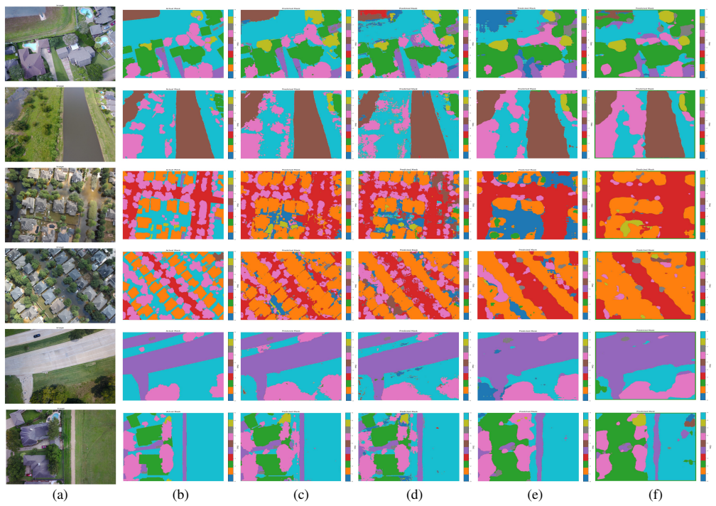
The central discovery, on the paper's own terms, is that a frozen self-supervised vision transformer pretrained on natural images produces features that improve flooded-region segmentation on aerial images when concatenated with the encoder bottleneck features of standard segmentation networks, without fine-tuning the feature extractor. On FloodNet, DINOv2+DeepLabV3 raises mIoU from 41.03 for DeepLabV3 to 47.39, while DINOv2+U-Net reaches 54.26 mIoU, the best score among the compared models. The authors attribute the transfer to DINOv2's pretraining on natural-image datasets such as ADE20k and Cityscapes, whose classes include buildings, roads, and vehicles that resemble flood-affected infrastructure, and they combine a class-frequency-weighted focal loss with dice loss to counter the dataset's severe class imbalance.
Load-bearing premise
The load-bearing premise is that the reported mIoU gains come from DINOv2 feature fusion, but the baseline models were not trained with the same combined dice and modified focal loss, so the improvement could be due to the loss function instead of the features.
Editorial extensions
If this is right
- Fusing frozen DINOv2 features into DeepLabV3 raises FloodNet mIoU by 6.36 points over DeepLabV3 and by 7.55 over E-Net, with the largest per-class gains on flooded building and road classes.
- DINOv2+U-Net reaches 54.26 mIoU, the best score among the compared models, improving over vanilla U-Net by 0.79 and over E-Net by 14.42.
- DINOv2 features trained on non-aerial images can serve as a frozen feature extractor for aerial segmentation, making fine-tuning of the feature extractor unnecessary.
- Combining dice loss with class-frequency-weighted focal loss yields higher mIoU than either loss alone for the proposed DINOv2+U-Net model.
Reading between the lines
- A decisive apples-to-apples test would retrain vanilla U-Net and DeepLabV3 under the same dice-plus-weighted-focal loss; the paper's loss ablation shows loss choice alone moves mIoU by several points, so the feature-specific contribution may be smaller than the headline comparison suggests.
- The same frozen-feature fusion recipe could apply to other disaster-response segmentation tasks, such as building-damage or landslide mapping, where labeled aerial data are scarce.
- Because DINOv2 was pretrained partly on urban scene datasets, its transfer may be strongest for classes that resemble infrastructure; evaluating on aerial datasets without buildings or roads would reveal how general the feature transfer really is.
Editorial analysis
A structured set of objections, weighed in public.
Referee Report
Summary. The paper proposes two segmentation models, DINOv2+U-Net and DINOv2+DeepLabV3, which concatenate frozen DINOv2 features with the conventional encoder bottleneck for flooded-region segmentation in UAV imagery. The authors evaluate on FloodNet, report mIoU values of 54.26 for DINOv2+U-Net and 47.39 for DINOv2+DeepLabV3, and claim that DINOv2 self-supervised features trained on natural images transfer to aerial images. They also introduce a class-frequency-weighted focal loss combined with Dice loss, and ablate loss choices in Section 5.3.
Significance. If the central claim is upheld, the paper would provide a practical demonstration that frozen self-supervised DINOv2 features serve as off-the-shelf extractors for aerial flood segmentation, reducing the need for domain-specific pretraining and large annotated UAV datasets. The paper has clear strengths: it uses a fixed public benchmark, describes the feature-fusion architectures explicitly, reports per-class IoU, and includes a loss ablation that partially exposes sensitivity to training choices. However, the current evidence is only partial: the headline comparison does not control for a simultaneous change in loss function, the loss ablation is internally inconsistent for DeepLabV3, and no error bars or multiple runs are reported. These issues are fixable within the manuscript's scope, but they must be addressed before the transferability claim can be accepted.
major comments (3)
- [Section 5.1, Table 2 vs. Section 4.3, Eq. (5)] The headline improvements are confounded with a change in the loss function. The proposed models are trained with Dice + modified focal loss (Eq. 5), while the baselines (E-Net, U-Net, DeepLabV3) are reported without stating their training loss or schedule. The 6.36 mIoU gain of DINOv2+DeepLabV3 over DeepLabV3 therefore cannot be attributed to DINOv2 features. The paper's own Table 3 shows the confound: with Dice alone, DINOv2+DeepLabV3 scores 37.46 mIoU, below vanilla DeepLabV3's 41.03, and with Focal alone it scores 53.66. To support the attribution, the authors need to retrain all baselines under identical loss, optimizer, resolution, and epochs, or at least report a same-loss control such as vanilla DeepLabV3 trained with the Dice+modified focal loss.
- [Section 5.3, Table 3] The choice of Dice+Modified Focal as the final loss for DINOv2-DeepLabV3 is not supported by the paper's own ablation. Table 3 shows that DINOv2+DeepLabV3 with Focal alone achieves 53.66 mIoU, while Dice+Modified Focal achieves only 47.39, a difference of 6.27 points in favor of Focal alone. The text states that 'a combination of dice and modified focal loss presents a higher mIoU compared to all other loss functions,' but that statement is made only for DINOv2-U-Net. For DeepLabV3, the reported final configuration is worse than the focal-only variant, so the method selection is internally inconsistent and requires either changing the reported final model or providing a justification for preferring the lower-scoring configuration.
- [Section 5.1 and Table 2] No error bars or multiple runs are reported for any configuration, which makes the quantitative claims unverifiable. The U-Net gain is only 0.79 mIoU (54.26 vs. 53.47 for DINOv2+U-Net vs. Vanilla U-Net), and this could easily fall within run-to-run variation. Table 3 also shows extreme instability across losses for the same architecture, for example Vehicle IoU ranges from 0.00 to 39.80 for DINOv2+U-Net and several classes drop to 0.00 for DINOv2+DeepLabV3 with Dice loss. Reporting single-run numbers without variance or a multi-seed average undermines the reliability of the improvements claimed in the paper.
minor comments (5)
- [Section 6] The conclusion contains an incomplete sentence: 'While the DINOv2-DeepLabV3 model shows a significant improvement of 6.36' ends without completing the comparison or specifying units; the sentence should be finished.
- [Abstract] The code availability statement says 'To access the repository, visit the link (GitHub Link),' which is a placeholder rather than a working URL; the repository should be cited with an actual link, DOI, or repository identifier.
- [Section 5.1] The claim that DINOv2 was trained on ADE20k and Cityscapes is inaccurate for the DINOv2 model of [10], which is pretrained on LVD-142M; this attribution should be corrected or qualified.
- [References] References [7] and [20] are the same paper (Majidizadeh et al., ISPRS Annals 2022) and should be merged or distinguished in the bibliography.
- [Abstract and Section 5.1] The abstract claims that the method enables 'high-accuracy segmentation with limited labeled aerial data,' but all experiments use the full 1445-image training set; no experiment varies the amount of labeled data, so this claim is not supported by the reported evaluation.
Circularity Check
No significant circularity: feature-transfer claim rests on external FloodNet benchmarks; the loss-confound concern is a soundness gap, not a circular derivation.
full rationale
The paper's central claim is that frozen DINOv2 features improve flood segmentation on FloodNet. The evidence is an empirical comparison against external baselines (U-Net, DeepLabV3, E-Net) on a fixed public benchmark (Table 2), so the claim is not derived from the fitted loss parameters or from a self-citation. The inverse-frequency alpha values in Eqs. (2)-(3) and Table 1 are hyperparameters of the proposed loss, and the mIoU numbers are measurements, not algebraic consequences of those alphas. The only self-citations (refs [39]-[40]) are contextual related-work references about UAV disaster assessment; they are not load-bearing for the feature-transfer conclusion. The soundness issue identified by the skeptical reading - that Table 2 baselines may have been trained with a different loss than the proposed dice+modified focal loss, while Table 3 shows DINOv2+DeepLabV3 with Dice alone reaching 37.46 mIoU versus DeepLabV3's 41.03 - is a missing-control/attribution concern, not circularity. It does not reduce any equation to its inputs or rename a fitted parameter as a prediction. Accordingly no circular step is exhibited, and the score reflects only the minor, non-load-bearing self-citations.
Assumptions & free parameters
free parameters (5)
- Per-class alpha weights for weighted focal loss =
Table 1: Background 0.08, Building Flooded 0.14, Building Non-Flooded 0.10, Road Flooded 0.10, Road Non-Flooded 0.05…
- Per-class beta offsets =
Unreported; selected between -0.20 and 0.20 for each class
- Loss combination weight w =
0.5
- Focal loss gamma =
4.0
- Input resolution =
448x448
assumptions (4)
- domain assumption DINOv2 features trained on natural images transfer to aerial imagery without fine-tuning.
- domain assumption The fixed 60/20/20 split of FloodNet is a representative evaluation of flood segmentation performance.
- domain assumption The combined Dice and weighted focal loss is appropriate for the class imbalance in FloodNet.
- domain assumption Ground truth annotations in FloodNet are correct.
Cite this review
Pith. "Pith review of Leveraging Self-Supervised Features for Efficient Flooded Region Identification in UAV Aerial Images." pith.science (2026). https://pith.science/paper/S6SXX3YN
@misc{pith2026250704915,
  author       = {Pith},
  title        = {Pith review of: Leveraging Self-Supervised Features for Efficient Flooded Region Identification in UAV Aerial Images},
  year         = {2026},
  howpublished = {\url{https://pith.science/paper/S6SXX3YN}},
  note         = {Machine review of arXiv:2507.04915}
}
read the original abstract
Identifying regions affected by disasters is a vital step in effectively managing and planning relief and rescue efforts. Unlike the traditional approaches of manually assessing post-disaster damage, analyzing images of Unmanned Aerial Vehicles (UAVs) offers an objective and reliable way to assess the damage. In the past, segmentation techniques have been adopted to identify post-flood damage in UAV aerial images. However, most of these supervised learning approaches rely on manually annotated datasets. Indeed, annotating images is a time-consuming and error-prone task that requires domain expertise. This work focuses on leveraging self-supervised features to accurately identify flooded regions in UAV aerial images. This work proposes two encoder-decoder-based segmentation approaches, which integrate the visual features learned from DINOv2 with the traditional encoder backbone. This study investigates the generalization of self-supervised features for UAV aerial images. Specifically, we evaluate the effectiveness of features from the DINOv2 model, trained on non-aerial images, for segmenting aerial images, noting the distinct perspectives between the two image types. Our results demonstrate that DINOv2's self-supervised pretraining on natural images generates transferable, general-purpose visual features that streamline the development of aerial segmentation workflows. By leveraging these features as a foundation, we significantly reduce reliance on labor-intensive manual annotation processes, enabling high-accuracy segmentation with limited labeled aerial data.
Figures


Figures from the paper (1 more)

Reference graph
Works this paper leans on
-
[1]
Delforge, D. et al. Em-dat: The emergency events database. Tech. Rep., UCLouvain, USAID and Centre for Research on the Epidemiology of Disasters (CRED) (2023). DOI: 10.21203/rs.3.rs-3807553/v1
-
[2]
& Srinivasa, G.Flood Disaster Management (National Remote Sensing Centre, 2010)
Bhanumurthy, V ., Manjusree, P. & Srinivasa, G.Flood Disaster Management (National Remote Sensing Centre, 2010)
work page 2010
-
[3]
The limitations of traditional surveying techniques in a forested environment
Alexander, D. The limitations of traditional surveying techniques in a forested environment. J. Field Archaeol. 10, 177–186 (1983)
work page 1983
-
[4]
Malakeel, G. S., Abdu Rahiman, K. U. & Vishnudas, S. Flood risk assessment methods—a review. In Thomas, J., Jayalekshmi, B. & Nagarajan, P. (eds.) Current Trends in Civil Engineering, 197–208, DOI: 10.1007/978-981-15-8151-9 19 (Springer Singapore, Singapore, 2021)
-
[5]
Emilien, A.-V ., Thomas, C. & Houet, T. Uav and satellite synergies for optical remote sensing applications: a literature review. Sci. Remote. Sens. 3, 100019, DOI: 10.1016/j.srs.2021.100019 (2021)
arXiv 2021
-
[6]
Matsimbe, J., Mdolo, W., Kapachika, C., Musonda, I. & Dinka, M. Comparative utilization of drone technology vs. traditional methods in open pit stockpile volumetric computation: A case of njuli quarry, malawi. Front. Built Environ. 8, DOI: 10.3389/fbuil.2022.1037487 (2022)
-
[8]
Ozbulak, U. et al. Know your self-supervised learning: A survey on image-based generative and discriminative training. Transactions on Mach. Learn. Res. (2023). Survey Certification
work page 2023
- [9]
Show all 47 references
-
[10]
Oquab, M. et al. DINOv2: Learning robust visual features without supervision. Transactions on Mach. Learn. Res. (2024)
2024
-
[11]
& Brox, T
Ronneberger, O., Fischer, P. & Brox, T. U-net: Convolutional networks for biomedical image segmentation. vol. 9351, 234–241, DOI: 10.1007/978-3-319-24574-4 28 (2015)
2015 doi
-
[12]
Yang, R. & Yu, Y . Artificial convolutional neural network in object detection and semantic segmentation for medical imaging analysis. Front. Oncol. 11, 638182, DOI: 10.3389/fonc.2021.638182 (2021)
2021
-
[13]
Li, W. et al. Semantic segmentation-based building footprint extraction using very high-resolution satellite images and multi-source gis data. Remote. Sens. 11, 403, DOI: 10.3390/rs11040403 (2019)
2019 doi
-
[14]
Feng, D. et al. Deep multi-modal object detection and semantic segmentation for autonomous driving: Datasets, methods, and challenges. IEEE Transactions on Intell. Transp. Syst. PP, 1–20, DOI: 10.1109/TITS.2020.2972974 (2020). 11/13
2020
-
[15]
Bentivoglio, R., Isufi, E., Jonkman, S. N. & Taormina, R. Deep learning methods for flood mapping: a review of existing applications and future research directions. Hydrol. Earth Syst. Sci. 26, 4345–4378 (2022)
2022
-
[16]
V ., Dobbs, D
Rahnemoonfar, M., Murphy, R., Miquel, M. V ., Dobbs, D. & Adams, A. Flooded area detection from uav images based on densely connected recurrent neural networks. In IGARSS 2018 - 2018 IEEE International Geoscience and Remote Sensing Symposium , 1788–1791, DOI: 10.1109/IGARSS.20...
2018
-
[17]
L., Ayele, E
Edamo, M. L., Ayele, E. G., Yisihak Ukumo, T., Alemayehu Kassaye, A. & Paulos Haile, A. Capability of logistic regression in identifying flood-susceptible areas in a small watershed. H2Open J. 7, 351–374, DOI: 10.2166/h2oj.2024.024 (2024). https: //iwaponline.com/h2open/articl...
2024 doi
-
[18]
& Darrell, T
Shelhamer, E., Long, J. & Darrell, T. Fully convolutional networks for semantic segmentation. IEEE Transactions on Pattern Analysis Mach. Intell. 39, 640–651, DOI: 10.1109/TPAMI.2016.2572683 (2017)
2017
-
[19]
& Cipolla, R
Badrinarayanan, V ., Kendall, A. & Cipolla, R. Segnet: A deep convolutional encoder-decoder architecture for image segmentation.IEEE transactions on pattern analysis machine intelligence 39, 2481–2495 (2017)
2017
-
[20]
& Jafari, M
Majidizadeh, A., Hasani, H. & Jafari, M. Semantic segmentation of uav images based on u-net in urban area. ISPRS Annals Photogramm. Remote. Sens. Spatial Inf. Sci. X-4/W1-2022, 451–457, DOI: 10.5194/isprs-annals-X-4-W1-2022-451-2023 (2023)
2023 doi
- [21]
-
[22]
& Adam, H
Chen, L.-C., Papandreou, G., Schroff, F. & Adam, H. Rethinking atrous convolution for semantic image segmentation (2017). 1706.05587
2017 arXiv
-
[23]
A progressive image semantic segmentation method using recurrent neural network
Yi, L. A progressive image semantic segmentation method using recurrent neural network. In 2021 6th International Conference on Intelligent Computing and Signal Processing (ICSP) , 765–768, DOI: 10.1109/ICSP51882.2021.9408920 (2021)
2021
-
[24]
Dosovitskiy, A. et al. An image is worth 16x16 words: Transformers for image recognition at scale. In International Conference on Learning Representations (2021)
2021
-
[25]
Touvron, H. et al. Training data-efficient image transformers and; distillation through attention. In Meila, M. & Zhang, T. (eds.) Proceedings of the 38th International Conference on Machine Learning , vol. 139 of Proceedings of Machine Learning Research , 10347–10357 (PMLR, 2021)
2021
-
[26]
Zheng, S. et al. Rethinking Semantic Segmentation from a Sequence-to-Sequence Perspective with Transformers . In 2021 IEEE/CVF Conference on Computer Vision and Pattern Recognition (CVPR) , 6877–6886, DOI: 10.1109/CVPR46437.2021.00681 (IEEE Computer Society, Los Alamitos, CA, ...
2021
-
[27]
& Schmid, C
Strudel, R., Garcia, R., Laptev, I. & Schmid, C. Segmenter: Transformer for Semantic Segmentation . In 2021 IEEE/CVF International Conference on Computer Vision (ICCV), 7242–7252, DOI: 10.1109/ICCV48922.2021.00717 (IEEE Computer Society, Los Alamitos, CA, USA, 2021)
2021
-
[28]
Fully self-supervised learning for semantic segmentation
Wang, Y .et al. Fully self-supervised learning for semantic segmentation. arXiv preprint arXiv:2202.11981 (2022)
2022 arXiv
-
[29]
& Wang, Q
Cheng, J., Deng, C., Su, Y ., An, Z. & Wang, Q. Methods and datasets on semantic segmentation for unmanned aerial vehicle remote sensing images: A review. ISPRS J. Photogramm. Remote. Sens. 211, 1–34, DOI: https://doi.org/10.1016/j.isprsjprs.2024.03.012 (2024)
2024 doi
-
[30]
Wang, L. et al. Unetformer: A unet-like transformer for efficient semantic segmentation of remote sensing urban scene imagery. ISPRS J. Photogramm. Remote. Sens. 190, 196–214, DOI: 10.1016/j.isprsjprs.2022.06.008 (2022)
2022 doi
-
[31]
Wei, Y ., Wang, Z. & Xu, M. Road structure refined cnn for road extraction in aerial image. IEEE Geosci. Remote. Sens. Lett. 14, 709–713, DOI: 10.1109/LGRS.2017.2672734 (2017)
2017
-
[32]
Marmanis, D. et al. Classification with an edge: Improving semantic image segmentation with boundary detection.ISPRS J. Photogramm. Remote. Sens. 135, DOI: 10.1016/j.isprsjprs.2017.11.009 (2016)
2016 doi
-
[33]
Li, R. et al. Abcnet: Attentive bilateral contextual network for efficient semantic segmentation of fine-resolution remotely sensed imagery. ISPRS J. Photogramm. Remote. Sens. 181, 84–98, DOI: https://doi.org/10.1016/j.isprsjprs.2021.09.005 (2021)
2021 doi
-
[34]
Yang, J. et al. Dinov2-based uav visual self-localization in low-altitude urban environments. IEEE Robotics Autom. Lett. 10, 2080–2087, DOI: 10.1109/LRA.2025.3527762 (2025)
2025
-
[35]
& Chen, G
Shi, L., Yang, K., Chen, Y . & Chen, G. An interactive prompt based network for urban floods area segmentation using uav images.IEEE J. Sel. Top. Appl. Earth Obs. Remote. Sens. 18, 935–948, DOI: 10.1109/JSTARS.2024.3498865 (2025). 12/13
2025
-
[36]
A review of flood damage analysis for a building structure and contents
Tavanaie Marvi, M. A review of flood damage analysis for a building structure and contents. Nat. Hazards 102, DOI: 10.1007/ s11069-020-03941-w (2020)
2020
-
[37]
& Fukushi, K
Kefi, M., Mishra, B., Masago, Y . & Fukushi, K. Analysis of flood damage and influencing factors in urban catchments: case studies in manila, philippines, and jakarta, indonesia. Nat. Hazards 104, DOI: 10.1007/s11069-020-04281-5 (2020)
2020 doi
-
[38]
& Pang, G
Doshi, J., Basu, S. & Pang, G. From satellite imagery to disaster insights. arXiv preprint arXiv:1812.07033 (2018)
2018 arXiv
-
[39]
Recent trends and challenges in analysis of uav aerial images for post-disaster scene understanding
Verma, U. Recent trends and challenges in analysis of uav aerial images for post-disaster scene understanding. In IGARSS 2022 - 2022 IEEE International Geoscience and Remote Sensing Symposium , 4647–4649, DOI: 10.1109/IGARSS46834.2022.9883265 (2022)
2022
-
[40]
& Verma, U
Sharma, A. & Verma, U. Flood magnitude assessment from uav aerial videos based on image segmentation and similarity. In TENCON 2021 - 2021 IEEE Region 10 Conference (TENCON) , 476–481, DOI: 10.1109/TENCON54134.2021.9707250 (2021)
2021
-
[41]
& Hauptmann, A
Zhu, X., Liang, J. & Hauptmann, A. Msnet: A multilevel instance segmentation network for natural disaster damage assessment in aerial videos. 2022–2031, DOI: 10.1109/W ACV48630.2021.00207 (2021)
2021
-
[42]
Wu, C. et al. Building damage detection using u-net with attention mechanism from pre- and post-disaster remote sensing datasets. Remote. Sens. 13, 905, DOI: 10.3390/rs13050905 (2021)
2021 doi
-
[43]
Rahnemoonfar, M. et al. Floodnet: A high resolution aerial imagery dataset for post flood scene understanding. IEEE Access 9, 89644–89654, DOI: 10.1109/ACCESS.2021.3090981 (2021)
2021
-
[44]
& Doll´ar, P
Lin, T.-Y ., Goyal, P., Girshick, R., He, K. & Doll´ar, P. Focal loss for dense object detection. In Proceedings of the IEEE international conference on computer vision, 2980–2988 (2017)
2017
-
[45]
H., Li, W., Vercauteren, T., Ourselin, S
Sudre, C. H., Li, W., Vercauteren, T., Ourselin, S. & Jorge Cardoso, M. Generalised dice overlap as a deep learning loss function for highly unbalanced segmentations. In Deep Learning in Medical Image Analysis and Multimodal Learning for Clinical Decision Support: Third Intern...
2017
-
[46]
& Culurciello, E
Paszke, A., Chaurasia, A., Kim, S. & Culurciello, E. Enet: A deep neural network architecture for real-time semantic segmentation. arXiv preprint arXiv:1606.02147 (2016)
2016 arXiv
-
[47]
Zhou, B. et al. Scene parsing through ade20k dataset. In 2017 IEEE Conference on Computer Vision and Pattern Recognition (CVPR) , 5122–5130, DOI: 10.1109/CVPR.2017.544 (2017)
2017 doi
-
[48]
Cordts, M. et al. The cityscapes dataset for semantic urban scene understanding. In 2016 IEEE Conference on Computer Vision and Pattern Recognition (CVPR), 3213–3223, DOI: 10.1109/CVPR.2016.350 (2016). 13/13
2016 doi
Reviewed August 6, 2026 · model on record in the stance chip above.
Discussion (0). Sign in to comment.