REVIEW 4 major objections 5 minor 73 references
Cross-View Localization via Redundant Sliced Observations and A-Contrario Validation
T0 review · 4 major / 5 minor · reviewed 2026-08-05 · deepseek-v4-flash
Pith's one-line read The paper claims that a single panorama cannot certify its own pose, but twelve mutually checking slices of it can, and the redundancy yields both higher accuracy and a principled way to reject wrong answers.
desk verdict The slicing idea and the dataset are genuinely useful, and the accuracy gains look real, but the a-contrario reliability model has load-bearing flaws, so the 88% failure-detection claim is not yet supported. read the letter →
The pith
A machine-rendered reading of the paper's core claim, the machinery that carries it, and where it could break.
The reading
What carries the argument
OSA-CVL is the robust estimator at the heart of Slice-Loc. A slice pose's geometric error $\theta_i$ is the angle between the vector from a candidate camera position to the slice scene position and the slice's central imaging ray. A subset is $\alpha$-rigid if all its errors are at most $\alpha$. Pairs of slice poses generate candidate camera positions, and the best subset is the one minimizing the maximum error. Meaningfulness is judged by $\varepsilon(\alpha,n,k) = (n-2)\binom{n}{k}\binom{k}{2} Q(\alpha)^{k-2}$, where $Q(\alpha)$ is the null probability that one random slice has error below $\alpha$. The rule $\log \varepsilon < 0$ accepts the localization; otherwise it is rejected.
What would settle it
Corrupt all 12 slices of a set of query panoramas with the same systematic pose offset, as if the aerial reference were wrong in a consistent way, and run OSA-CVL. If the NFA still reports $\log \varepsilon < 0$ for many of these systematically biased inputs, the independent-slices product in the NFA bound overstates how unlikely the agreement is; under the paper's null model, randomly scattered slice errors should produce large NFA values.
Extended reading notes
Core claim
The paper's central claim is that cross-view localization should work like a surveying operation: produce redundant observations, cross-check them, then release a pose. Slice-Loc cuts a panorama into twelve overlapping sub-images and estimates each slice's 3-DoF pose in the aerial reference. Only slice poses that satisfy the panoramic rigidity constraint survive; the inliers are merged into the final pose, and an a-contrario number-of-false-alarms criterion decides whether the result is usable. Localizations that fail are discarded, not trusted. On DReSS cross-area, the method is reported to cut mean localization error from 4.47 m to 1.86 m and mean orientation error from 3.42 degrees to 1.2
Load-bearing premise
The NFA calculation assumes the 12 slice-pose estimates are statistically independent under the null hypothesis, even though the slices overlap and come from the same network and the same panorama; if their errors are correlated, the computed false-alarm probability is too optimistic.
Editorial extensions
If this is right
- In cross-area tests on DReSS, after filtering, Slice-Loc reduces mean localization error from 4.47 m to 1.86 m and mean orientation error from 3.42 degrees to 1.24 degrees, with fewer than 3% of localization errors above 10 m.
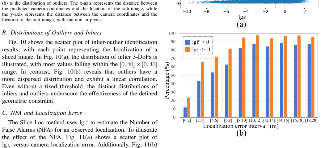
- The NFA indicator detects over 88% of failed localizations (errors greater than 10 m) in the DReSS cross-area setting, about 24% more than the CCVPE baseline.
- Increasing the slice count from 4 to 16 improves both accuracy and the reliability indicator, at modest cost: 12 slices give 96 ms per localization.
- When the aerial reference is wrong, the slice pose estimates scatter instead of converging, and the NFA test identifies mismatched ground-aerial pairs with roughly 90% negative recall in the random-reference experiment.
- A model trained on DReSS and tested on VIGOR cross-area gives 3.00 m mean error raw and 1.65 m after NFA filtering, indicating the reliability check transfers to another city set.
Reading between the lines
- Because the NFA also flags wrong reference images in the paper's retrieval experiment, the same machinery could act as a post-retrieval verification gate in a full coarse-to-fine pipeline; the paper does not claim that end-to-end system.
- The independence assumption behind the NFA is the fragile link: the 12 slices overlap and share the same network, so correlated errors would make the false-alarm bound optimistic. A reader could test this by injecting a common offset into all slices and checking whether wrong localizations still pass.
- The paper's scene-location supervision result suggests that 'predict where the scene is, not where the camera is' is the transferable training insight; this could be tested on other cross-view settings such as drone-to-satellite localization.
- If the reliability signal is trusted, autonomy systems could fuse only localizations with $\log \varepsilon < 0$ into downstream pose graphs and discard the rest; the paper presents the reliability check but not this behavioral consequence.
Editorial analysis
A structured set of objections, weighed in public.
Referee Report
Summary. The paper presents Slice-Loc, a two-stage cross-view localization method that slices a ground-level panorama into 12 overlapping sub-images, estimates a 3-DoF pose for each slice with the CCVPE network, and then uses a RANSAC-like geometric-rigidity procedure to select inlier slice poses and compute a camera pose. The second contribution is an a-contrario NFA-based reliability score, lg(epsilon), intended to reject failed localizations; a threshold tau=0 is used to filter unreliable results. The paper also introduces DReSS-D, a pixel-level extension of DReSS with depth maps, and reports strong experimental gains on DReSS and VIGOR, including a reduction in cross-area mean localization error from 4.47 m to 1.86 m after filtering and an RoTN of about 88.5% on DReSS.
Significance. If the results hold, the redundant-slice formulation is a useful step toward reliability-aware cross-view localization, and DReSS-D is a valuable dataset contribution. The raw accuracy gains from redundant observations and robust estimation are plausible and are measured against ground truth; they do not depend on the NFA computation. The code-release promise and the extensive comparisons on DReSS and VIGOR are also strengths. However, the paper's headline failure-detection claim depends on the NFA derivation, and that derivation currently has three concrete problems: the independence assumption in Eq. (17) is unsupported, the printed q(theta) in Eq. (18) is not a valid density, and the exponent in Eq. (21) is inconsistent with Eq. (23). These issues affect the numerical NFA values and therefore the accept/reject decision, so the reliability claims are not yet supported as written.
major comments (4)
- [Section IV-B, Eq. (17)] The proof of Eq. (15) explicitly assumes that the 12 slice pose errors are mutually independent under H0. This is not justified: the slices have an HFoV of 90 degrees with 30-degree spacing, so adjacent slices overlap by 60 degrees; they are extracted from the same panoramic image and processed by the same CCVPE network, so their errors are likely strongly correlated. If the errors are positively correlated, the true probability that all remaining slices have error <= alpha is larger than Q(alpha)^{n-2}, invalidating the upper bound and making the NFA too small and the threshold tau=0 too permissive. The RoTN numbers in Table II therefore do not currently support the failure-detection claim. I am not asserting that the method fails; rather, the paper should either justify the independence assumption empirically or replace it with a defensible dependence model.
- [Section IV-C, Eq. (18)] The printed q(theta) is not a valid probability density. With t1=50, t2=132, A=-6.7e-5, and B=8.8e-4, the linear segment takes negative values throughout [50,132]: q(50) = -2.47e-3 and q(132) = -7.96e-3. It also does not vanish at t2, so the piecewise definition is discontinuous. Without valid coefficients, the normalized cumulative Q(theta) in Eq. (19) is not defined and the numerical NFA values in Tables II, V, VII, and VIII are not reproducible. Please correct the coefficients, specify C and K, and state the angular units consistently.
- [Section IV-D, Eqs. (21) and (23)] There is an exponent inconsistency. Eq. (21) defines epsilon(alpha,n,k) with Q(alpha)^{k-2}, while Eq. (23) derives the same epsilon using Q(alpha)^{n-2}. These cannot both be correct. Algorithm 1 explicitly evaluates Eq. (21), so the implemented quantity appears to use k-2, but then the derivation in Eq. (23) is wrong; if n-2 is intended, the definition in Eq. (21) and all thresholds computed in the experiments are wrong. The difference changes epsilon by orders of magnitude and must be resolved.
- [Section IV-C and Section VI-D] The null hypothesis q(theta) is fitted from approximately 2.6e5 'naive poses' produced by the same CCVPE pipeline. This makes the NFA a self-calibrated score rather than an externally defined a-contrario null. The statement that the parameters depend only on the localization task and not on the model or data is asserted but not established; the fitted q may absorb model-specific biases. The random-reference experiment in Table VII provides one operating point, but it does not validate the independence assumption or the density/exponent corrections. Please report a calibration analysis (e.g., reliability curve or ROC over negative references) and justify the choice tau=0 under the corrected formulas.
minor comments (5)
- [Section III-C, Eq. (1)] The angular mapping phi_i = 2*pi*x_i/W and omega_i = pi*y_i/H should be stated more carefully; as written, x=0 maps to phi=0 and y=H maps to omega=pi. Please clarify the equirectangular convention used and whether an offset is applied.
- [Section IV-B, Eqs. (9), (13), and (14)] The rigidity measure is defined as the maximum over slices in Eq. (13), but Eq. (9) and Algorithm 2 use the sum of theta_i to estimate pc. Please reconcile the two criteria or explain why the sum is used in the sampling step.
- [Section VI-A2, Table V] The text discusses 'RoP' while the table column is 'PoR'. Please use consistent terminology and define it. Also, the claim that RoP remains nearly constant as n varies from 16 to 4 should be checked against the listed values (80.00, 72.71, 74.54, 79.37, 81.28).
- [Section VI-A3, Table VI] The table header uses '^<5m' but the caption/text says 'errors exceeding 5 m'. Clarify whether the reported percentages are below or above the threshold.
- [General] Please perform a final proofread of mathematical notation, especially vector arrows in Eq. (8) and the typesetting of 'lg¯epsilon' in Algorithm 2. There are also several places where variable names such as 'k' and 'n' are used without immediate definition.
Circularity Check
No significant circularity: the core pose-merging and NFA reliability claims are not reductions to their inputs.
full rationale
The paper's accuracy improvements (Tables I and III) are measured against external ground-truth poses and use the CCVPE network only as a fixed feature extractor; the geometric rigidity filter and RANSAC-like inlier selection are standard robust estimation applied to the estimated slice poses, not fitted from the reported errors. The NFA computation is a standard a-contrario construction: Eq. (17) computes a tail probability under H0 from the angular-error distribution Q, Eq. (21)/(23) multiply by a combinatorial number of tests, and the threshold is the conventional NFA < 1. The null distribution q(theta) is empirically fitted from simulated naive pose outputs of the same pipeline (Sec. IV-C). That is a self-calibrated null rather than an external benchmark, and the independence assumption in Eq. (17) is questionable because slices overlap and share network features, but this is a statistical-validity concern, not a definitional circularity: the q parameters were not fitted to the target failure labels or to the reported error reductions. The self-citations ([35], [59], [71]) are not load-bearing; the geometric constraint and NFA formula are derived in-paper from the panoramic imaging model and the cited a-contrario theory is used only as a template. No quantity is fitted to the evaluation metric and then renamed a prediction. The internal inconsistencies (density q(theta) not nonnegative with the printed A,B; exponent Q(alpha)^{k-2} vs Q(alpha)^{n-2} between Eq. (21) and Eq. (23)) are correctness risks but do not make the derivation equivalent to its inputs.
Assumptions & free parameters
free parameters (5)
- q(theta) piecewise density parameters (t1, t2, A, B, C) =
t1=50 deg, t2=132 deg, A=-6.7e-5, B=8.8e-4, C implied by normalization
- Number of slices n =
12 (ablation tests 4, 6, 8, 12, 16)
- Slice HFoV/VFoV and VFoV center =
HFoV=90 deg, VFoV=90 deg, VFoV center omega_i=0.75*pi, pixel size 512x512
- Reliability threshold tau =
0 (lg epsilon < 0)
- Orientation prior range for reference rotation =
[45 deg, 135 deg]
assumptions (6)
- domain assumption Slice pose estimates are statistically independent under the null hypothesis
- ad hoc to paper Null hypothesis H0 with q(theta) fitted from simulated random-reference localizations
- domain assumption The scene position of a slice equals the mean of projected valid-depth pixels (Eq. 6-7)
- domain assumption Camera pitch, roll, and mounting height are known
- domain assumption Depth maps from Google Street View are accurate for generating pixel-level supervision
- standard math Counting bound N_sample <= (n-2)*C(n,k)*C(k,2)
Cite this review
Pith. "Pith review of Cross-View Localization via Redundant Sliced Observations and A-Contrario Validation." pith.science (2026). https://pith.science/paper/Q2WYP4UA
@misc{pith2026250805369,
  author       = {Pith},
  title        = {Pith review of: Cross-View Localization via Redundant Sliced Observations and A-Contrario Validation},
  year         = {2026},
  howpublished = {\url{https://pith.science/paper/Q2WYP4UA}},
  note         = {Machine review of arXiv:2508.05369}
}
abstract
Cross-view localization (CVL) matches ground-level images with aerial references to determine the geo-position of a camera, enabling smart vehicles to self-localize offline in GNSS-denied environments. However, most CVL methods output only a single observation, the camera pose, and lack the redundant observations required by surveying principles, making it challenging to assess localization reliability through the mutual validation of observational data. To tackle this, we introduce Slice-Loc, a two-stage method featuring an a-contrario reliability validation for CVL. Instead of using the query image as a single input, Slice-Loc divides it into sub-images and estimates the 3-DoF pose for each slice, creating redundant and independent observations. Then, a geometric rigidity formula is proposed to filter out the erroneous 3-DoF poses, and the inliers are merged to generate the final camera pose. Furthermore, we propose a model that quantifies the meaningfulness of localization by estimating the number of false alarms (NFA), according to the distribution of the locations of the sliced images. By eliminating gross errors, Slice-Loc boosts localization accuracy and effectively detects failures. After filtering out mislocalizations, Slice-Loc reduces the proportion of errors exceeding 10 m to under 3\%. In cross-city tests on the DReSS dataset, Slice-Loc cuts the mean localization error from 4.47 m to 1.86 m and the mean orientation error from $\mathbf{3.42^{\circ}}$ to $\mathbf{1.24^{\circ}}$, outperforming state-of-the-art methods. Code and dataset will be available at: https://github.com/bnothing/Slice-Loc.
Figures


Figures from the paper (10 more)




Reference graph
Works this paper leans on
-
[1]
University-1652: A multi-view multi- source benchmark for drone-based geo-localization,
Z. Zheng, Y . Wei, and Y . Yang, “University-1652: A multi-view multi- source benchmark for drone-based geo-localization,” in Proceedings of the 28th ACM international conference on Multimedia , 2020, pp. 1395– 1403
work page 2020
-
[2]
S. Srivastava, J. E. Vargas-Munoz, and D. Tuia, “Understanding urban landuse from the above and ground perspectives: A deep learning, multimodal solution,” Remote sensing of environment, vol. 228, pp. 129– 143, 2019
work page 2019
-
[3]
Urban zoning using higher-order markov random fields on multi-view imagery data,
T. Feng, Q.-T. Truong, D. T. Nguyen, J. Y . Koh, L.-F. Yu, A. Binder, and S.-K. Yeung, “Urban zoning using higher-order markov random fields on multi-view imagery data,” in Proceedings of the European Conference on Computer Vision (ECCV) , 2018, pp. 614–630
work page 2018
-
[4]
1 year, 1000 km: The oxford robotcar dataset,
W. Maddern, G. Pascoe, C. Linegar, and P. Newman, “1 year, 1000 km: The oxford robotcar dataset,” The International Journal of Robotics Research, vol. 36, no. 1, pp. 3–15, 2017
work page 2017
-
[5]
H. Li, F. Deuser, W. Yin, X. Luo, P. Walther, G. Mai, W. Huang, and M. Werner, “Cross-view geolocalization and disaster mapping with street-view and vhr satellite imagery: A case study of hurricane ian,” ISPRS Journal of Photogrammetry and Remote Sensing , vol. 220, pp. 841–854, 2025
work page 2025
-
[6]
Sg- bev: satellite-guided bev fusion for cross-view semantic segmentation,
J. Ye, Q. Luo, J. Yu, H. Zhong, Z. Zheng, C. He, and W. Li, “Sg- bev: satellite-guided bev fusion for cross-view semantic segmentation,” in Proceedings of the IEEE/CVF Conference on Computer Vision and Pattern Recognition, 2024, pp. 27 748–27 757
work page 2024
-
[7]
Cross-view object geo-localization in a local region with satellite imagery,
Y . Sun, Y . Ye, J. Kang, R. Fernandez-Beltran, S. Feng, X. Li, C. Luo, P. Zhang, and A. Plaza, “Cross-view object geo-localization in a local region with satellite imagery,” IEEE Transactions on Geoscience and Remote Sensing, vol. 61, pp. 1–16, 2023
work page 2023
-
[8]
A coarse-to-fine visual geo-localization method for gnss-denied uav with oblique-view imagery,
Q. Ye, J. Luo, and Y . Lin, “A coarse-to-fine visual geo-localization method for gnss-denied uav with oblique-view imagery,” ISPRS Journal of Photogrammetry and Remote Sensing , vol. 212, pp. 306–322, 2024
work page 2024
Show all 73 references
-
[9]
Vigor: Cross-view image geo-localization beyond one-to-one retrieval,
S. Zhu, T. Yang, and C. Chen, “Vigor: Cross-view image geo-localization beyond one-to-one retrieval,” in Proceedings of the IEEE/CVF Confer- ence on Computer Vision and Pattern Recognition, 2021, pp. 3640–3649
2021
-
[10]
Wide-area image geolo- calization with aerial reference imagery,
S. Workman, R. Souvenir, and N. Jacobs, “Wide-area image geolo- calization with aerial reference imagery,” in Proceedings of the IEEE International Conference on Computer Vision , 2015, pp. 3961–3969
2015
-
[11]
Lending orientation to neural networks for cross- view geo-localization,
L. Liu and H. Li, “Lending orientation to neural networks for cross- view geo-localization,” in Proceedings of the IEEE/CVF conference on computer vision and pattern recognition , 2019, pp. 5624–5633
2019
-
[12]
Cross-view geo-localization with street-view and vhr satel- lite imagery in decentrality settings,
P. Xia, L. Yu, Y . Wan, Q. Wu, P. Chen, L. Zhong, Y . Yao, D. Wei, X. Liu, L. Ru et al., “Cross-view geo-localization with street-view and vhr satel- lite imagery in decentrality settings,” arXiv preprint arXiv:2412.11529 , 2024
2024 arXiv
-
[13]
Vision meets robotics: The kitti dataset,
A. Geiger, P. Lenz, C. Stiller, and R. Urtasun, “Vision meets robotics: The kitti dataset,” The international journal of robotics research, vol. 32, no. 11, pp. 1231–1237, 2013. 17
2013
-
[14]
Ford multi-av seasonal dataset,
S. Agarwal, A. V ora, G. Pandey, W. Williams, H. Kourous, and J. McBride, “Ford multi-av seasonal dataset,” The International Journal of Robotics Research , vol. 39, no. 12, pp. 1367–1376, 2020
2020
-
[15]
Mccg: A convnext- based multiple-classifier method for cross-view geo-localization,
T. Shen, Y . Wei, L. Kang, S. Wan, and Y .-H. Yang, “Mccg: A convnext- based multiple-classifier method for cross-view geo-localization,” IEEE Transactions on Circuits and Systems for Video Technology , vol. 34, no. 3, pp. 1456–1468, 2023
2023
-
[16]
Cross- view image geo-localization with panorama-bev co-retrieval network,
J. Ye, Z. Lv, W. Li, J. Yu, H. Yang, H. Zhong, and C. He, “Cross- view image geo-localization with panorama-bev co-retrieval network,” in European Conference on Computer Vision . Springer, 2024, pp. 74– 90
2024
-
[17]
Sample4geo: Hard negative sam- pling for cross-view geo-localisation,
F. Deuser, K. Habel, and N. Oswald, “Sample4geo: Hard negative sam- pling for cross-view geo-localisation,” in Proceedings of the IEEE/CVF International Conference on Computer Vision, 2023, pp. 16 847–16 856
2023
-
[18]
Fine-grained cross- view geo-localization using a correlation-aware homography estimator,
X. Wang, R. Xu, Z. Cui, Z. Wan, and Y . Zhang, “Fine-grained cross- view geo-localization using a correlation-aware homography estimator,” Advances in Neural Information Processing Systems , vol. 36, pp. 5301– 5319, 2023
2023
-
[19]
Geometry-guided street- view panorama synthesis from satellite imagery,
Y . Shi, D. Campbell, X. Yu, and H. Li, “Geometry-guided street- view panorama synthesis from satellite imagery,” IEEE Transactions on Pattern Analysis and Machine Intelligence , vol. 44, no. 12, pp. 10 009– 10 022, 2022
2022
-
[20]
A survey on visual-based localization: On the benefit of heterogeneous data,
N. Piasco, D. Sidib ´e, C. Demonceaux, and V . Gouet-Brunet, “A survey on visual-based localization: On the benefit of heterogeneous data,” Pattern Recognition, vol. 74, pp. 90–109, 2018
2018
-
[21]
Large-scale image retrieval with attentive deep local features,
H. Noh, A. Araujo, J. Sim, T. Weyand, and B. Han, “Large-scale image retrieval with attentive deep local features,” in Proceedings of the IEEE international conference on computer vision , 2017, pp. 3456–3465
2017
-
[22]
C-bev: Contrastive bird’s eye view training for cross-view image retrieval and 3-dof pose estimation,
F. Fervers, S. Bullinger, C. Bodensteiner, M. Arens, and R. Stiefelhagen, “C-bev: Contrastive bird’s eye view training for cross-view image retrieval and 3-dof pose estimation,” arXiv preprint arXiv:2312.08060 , 2023
2023 arXiv
-
[23]
Uncertainty-aware vision-based metric cross-view geolocalization,
Fervers, Florian and Bullinger, Sebastian and Bodensteiner, Christoph and Arens, Michael and Stiefelhagen, Rainer, “Uncertainty-aware vision-based metric cross-view geolocalization,” in Proceedings of the IEEE/CVF Conference on Computer Vision and Pattern Recognition , 2023, p...
2023
-
[24]
Beyond cross-view image retrieval: Highly accu- rate vehicle localization using satellite image,
Y . Shi and H. Li, “Beyond cross-view image retrieval: Highly accu- rate vehicle localization using satellite image,” in Proceedings of the IEEE/CVF Conference on Computer Vision and Pattern Recognition , 2022, pp. 17 010–17 020
2022
-
[25]
Im2gps: estimating geographic information from a single image,
J. Hays and A. A. Efros, “Im2gps: estimating geographic information from a single image,” in 2008 ieee conference on computer vision and pattern recognition. IEEE, 2008, pp. 1–8
2008
-
[26]
Cross-view image geolocalization,
T.-Y . Lin, S. Belongie, and J. Hays, “Cross-view image geolocalization,” in Proceedings of the IEEE Conference on Computer Vision and Pattern Recognition, 2013, pp. 891–898
2013
-
[27]
Fast approximate nearest neighbor search with the navigating spreading-out graph,
C. Fu, C. Xiang, C. Wang, and D. Cai, “Fast approximate nearest neighbor search with the navigating spreading-out graph,” arXiv preprint arXiv:1707.00143, 2017
2017 arXiv
-
[28]
Learning deep representa- tions for ground-to-aerial geolocalization,
T.-Y . Lin, Y . Cui, S. Belongie, and J. Hays, “Learning deep representa- tions for ground-to-aerial geolocalization,” in Proceedings of the IEEE conference on computer vision and pattern recognition, 2015, pp. 5007– 5015
2015
-
[29]
Cvm-net: Cross-view matching network for image-based ground-to-aerial geo-localization,
S. Hu, M. Feng, R. M. Nguyen, and G. H. Lee, “Cvm-net: Cross-view matching network for image-based ground-to-aerial geo-localization,” in Proceedings of the IEEE Conference on Computer Vision and Pattern Recognition, 2018, pp. 7258–7267
2018
-
[30]
Optimal feature transport for cross-view image geo-localization,
Y . Shi, X. Yu, L. Liu, T. Zhang, and H. Li, “Optimal feature transport for cross-view image geo-localization,” in Proceedings of the AAAI Conference on Artificial Intelligence , vol. 34, no. 07, 2020, pp. 11 990– 11 997
2020
-
[31]
Each part matters: Local patterns facilitate cross-view geo-localization,
T. Wang, Z. Zheng, C. Yan, J. Zhang, Y . Sun, B. Zheng, and Y . Yang, “Each part matters: Local patterns facilitate cross-view geo-localization,” IEEE Transactions on Circuits and Systems for Video Technology , vol. 32, no. 2, pp. 867–879, 2021
2021
-
[32]
Attention is all you need,
A. Vaswani, N. Shazeer, N. Parmar, J. Uszkoreit, L. Jones, A. N. Gomez, Ł. Kaiser, and I. Polosukhin, “Attention is all you need,” Advances in neural information processing systems , vol. 30, 2017
2017
-
[33]
Cross-view geo-localization with layer-to- layer transformer,
H. Yang, X. Lu, and Y . Zhu, “Cross-view geo-localization with layer-to- layer transformer,” Advances in Neural Information Processing Systems, vol. 34, pp. 29 009–29 020, 2021
2021
-
[34]
Transgeo: Transformer is all you need for cross-view image geo-localization,
S. Zhu, M. Shah, and C. Chen, “Transgeo: Transformer is all you need for cross-view image geo-localization,” in Proceedings of the IEEE/CVF Conference on Computer Vision and Pattern Recognition , 2022, pp. 1162–1171
2022
-
[35]
Cross-view image set geo-localization,
Q. Wu, P. Xia, L. Yu, Y . Liu, M. Xiong, L. Zhong, J. Chen, M. Yang, Y . Zhang, and Y . Wan, “Cross-view image set geo-localization,” 2024. [Online]. Available: https://arxiv.org/abs/2412.18852
2024 arXiv
-
[36]
Spatial-aware feature aggregation for image based cross-view geo-localization,
Y . Shi, L. Liu, X. Yu, and H. Li, “Spatial-aware feature aggregation for image based cross-view geo-localization,” Advances in Neural Informa- tion Processing Systems , vol. 32, 2019
2019
-
[37]
Multi-scale attention encoder for street-to-aerial image geo-localization,
S. Li, Z. Tu, Y . Chen, and T. Yu, “Multi-scale attention encoder for street-to-aerial image geo-localization,” CAAI Transactions on Intelli- gence Technology, vol. 8, no. 1, pp. 166–176, 2023
2023
-
[38]
Cross-view image synthesis using conditional gans,
K. Regmi and A. Borji, “Cross-view image synthesis using conditional gans,” in Proceedings of the IEEE conference on Computer Vision and Pattern Recognition, 2018, pp. 3501–3510
2018
-
[39]
Multi- channel attention selection gan with cascaded semantic guidance for cross-view image translation,
H. Tang, D. Xu, N. Sebe, Y . Wang, J. J. Corso, and Y . Yan, “Multi- channel attention selection gan with cascaded semantic guidance for cross-view image translation,” in Proceedings of the IEEE/CVF confer- ence on computer vision and pattern recognition , 2019, pp. 2417–2426
2019
-
[40]
Coming down to earth: Satellite-to-street view synthesis for geo-localization,
A. Toker, Q. Zhou, M. Maximov, and L. Leal-Taix ´e, “Coming down to earth: Satellite-to-street view synthesis for geo-localization,” in Pro- ceedings of the IEEE/CVF Conference on Computer Vision and Pattern Recognition, 2021, pp. 6488–6497
2021
-
[41]
Road extraction assisted offset regression method in cross-view image-based geo-localization,
Y . Hou, Y . Yang, J. Wang, and M. Fu, “Road extraction assisted offset regression method in cross-view image-based geo-localization,” in 2022 IEEE 25th International Conference on Intelligent Transportation Systems (ITSC). IEEE, 2022, pp. 2934–2940
2022
-
[42]
Beyond geo-localization: Fine-grained orientation of street-view images by cross-view matching with satellite imagery,
W. Hu, Y . Zhang, Y . Liang, Y . Yin, A. Georgescu, A. Tran, H. Kruppa, S.-K. Ng, and R. Zimmermann, “Beyond geo-localization: Fine-grained orientation of street-view images by cross-view matching with satellite imagery,” in Proceedings of the 30th ACM international conference...
2022
-
[43]
Visual cross-view metric localization with dense uncertainty estimates,
Z. Xia, O. Booij, M. Manfredi, and J. F. Kooij, “Visual cross-view metric localization with dense uncertainty estimates,” in European Conference on Computer Vision . Springer, 2022, pp. 90–106
2022
-
[44]
Slicematch: Geometry- guided aggregation for cross-view pose estimation,
T. Lentsch, Z. Xia, H. Caesar, and J. F. Kooij, “Slicematch: Geometry- guided aggregation for cross-view pose estimation,” in Proceedings of the IEEE/CVF Conference on Computer Vision and Pattern Recognition, 2023, pp. 17 225–17 234
2023
-
[45]
Convolutional cross-view pose estima- tion,
Z. Xia, O. Booij, and J. F. Kooij, “Convolutional cross-view pose estima- tion,” IEEE Transactions on Pattern Analysis and Machine Intelligence , vol. 46, no. 5, pp. 3813–3831, 2023
2023
-
[46]
Boosting 3-dof ground-to-satellite camera localization accuracy via geometry-guided cross-view transformer,
Y . Shi, F. Wu, A. Perincherry, A. V ora, and H. Li, “Boosting 3-dof ground-to-satellite camera localization accuracy via geometry-guided cross-view transformer,” in Proceedings of the IEEE/CVF International Conference on Computer Vision , 2023, pp. 21 516–21 526
2023
-
[47]
View from above: Orthogonal-view aware cross- view localization,
S. Wang, C. Nguyen, J. Liu, Y . Zhang, S. Muthu, F. A. Maken, K. Zhang, and H. Li, “View from above: Orthogonal-view aware cross- view localization,” in Proceedings of the IEEE/CVF Conference on Computer Vision and Pattern Recognition , 2024, pp. 14 843–14 852
2024
-
[48]
An image is worth 16x16 words: Transformers for image recognition at scale,
A. Dosovitskiy, L. Beyer, A. Kolesnikov, D. Weissenborn, X. Zhai, T. Unterthiner, M. Dehghani, M. Minderer, G. Heigold, S. Gelly et al., “An image is worth 16x16 words: Transformers for image recognition at scale,” arXiv preprint arXiv:2010.11929 , 2020
2010 arXiv
-
[49]
Adapting fine-grained cross-view localization to areas without fine ground truth,
Z. Xia, Y . Shi, H. Li, and J. FP Kooij, “Adapting fine-grained cross-view localization to areas without fine ground truth,” in European Conference on Computer Vision . Springer, 2024, pp. 397–415
2024
-
[50]
Weakly-supervised cam- era localization by ground-to-satellite image registration,
Y . Shi, H. Li, A. Perincherry, and A. V ora, “Weakly-supervised cam- era localization by ground-to-satellite image registration,” in European Conference on Computer Vision . Springer, 2024, pp. 39–57
2024
-
[51]
A survey on monocular re- localization: From the perspective of scene map representation,
J. Miao, K. Jiang, T. Wen, Y . Wang, P. Jia, B. Wijaya, X. Zhao, Q. Cheng, Z. Xiao, J. Huang et al. , “A survey on monocular re- localization: From the perspective of scene map representation,” IEEE Transactions on Intelligent Vehicles, 2024
2024
-
[52]
Render then match: A neural radiance field-based indoor visual localization framework for lighting- varying environments using infrared images,
Q. Liu, Z. Liu, Q. Wu, P. Xia, and Y . Wan, “Render then match: A neural radiance field-based indoor visual localization framework for lighting- varying environments using infrared images,” The Photogrammetric Record, vol. 40, no. 189, p. e70002, 2025
2025
-
[53]
Robust estimation in robot vision and photogrammetry: a new model and its applications,
J. Li, Y . Zhang, and Q. Hu, “Robust estimation in robot vision and photogrammetry: a new model and its applications,” ISPRS Annals of the Photogrammetry, Remote Sensing and Spatial Information Sciences , vol. 1, pp. 137–144, 2021
2021
-
[54]
Random sample consensus: a paradigm for model fitting with applications to image analysis and automated car- tography,
M. FISCHLER AND, “Random sample consensus: a paradigm for model fitting with applications to image analysis and automated car- tography,” Commun. ACM, vol. 24, no. 6, pp. 381–395, 1981
1981
-
[55]
Mods: Fast and robust method for two-view matching,
D. Mishkin, J. Matas, and M. Perdoch, “Mods: Fast and robust method for two-view matching,” Computer vision and image understanding, vol. 141, pp. 81–93, 2015
2015
-
[56]
Qgore: Quadratic-time guaranteed outlier removal for point cloud registration,
J. Li, P. Shi, Q. Hu, and Y . Zhang, “Qgore: Quadratic-time guaranteed outlier removal for point cloud registration,” IEEE Transactions on 18 Pattern Analysis and Machine Intelligence , vol. 45, no. 9, pp. 11 136– 11 151, 2023
2023
-
[57]
A probabilistic criterion to detect rigid point matches between two images and estimate the fundamental matrix,
L. Moisan and B. Stival, “A probabilistic criterion to detect rigid point matches between two images and estimate the fundamental matrix,” International Journal of Computer Vision , vol. 57, pp. 201–218, 2004
2004
-
[58]
Automatic homographic reg- istration of a pair of images, with a contrario elimination of outliers,
L. Moisan, P. Moulon, and P. Monasse, “Automatic homographic reg- istration of a pair of images, with a contrario elimination of outliers,” Image Processing On Line , vol. 2, pp. 56–73, 2012
2012
-
[59]
The p2l method of mismatch detection for push broom high-resolution satellite images,
Y . Wan and Y . Zhang, “The p2l method of mismatch detection for push broom high-resolution satellite images,” ISPRS Journal of Photogram- metry and Remote Sensing , vol. 130, pp. 317–328, 2017
2017
-
[60]
Satellite image based cross-view localization for autonomous vehicle,
S. Wang, Y . Zhang, A. V ora, A. Perincherry, and H. Li, “Satellite image based cross-view localization for autonomous vehicle,” in 2023 IEEE International Conference on Robotics and Automation (ICRA) . IEEE, 2023, pp. 3592–3599
2023
-
[61]
Meaningful alignments,
A. Desolneux, L. Moisan, and J.-M. Morel, “Meaningful alignments,” International journal of computer vision , vol. 40, pp. 7–23, 2000
2000
-
[62]
A contrario mosaic analysis for image forensics,
Q. Bammey, “A contrario mosaic analysis for image forensics,” in International Conference on Advanced Concepts for Intelligent Vision Systems. Springer, 2023, pp. 222–234
2023
-
[63]
Lsd: A fast line segment detector with a false detection control,
R. G. V on Gioi, J. Jakubowicz, J.-M. Morel, and G. Randall, “Lsd: A fast line segment detector with a false detection control,” IEEE transactions on pattern analysis and machine intelligence , vol. 32, no. 4, pp. 722– 732, 2008
2008
-
[64]
Accurate junction detection and characterization in natural images,
G.-S. Xia, J. Delon, and Y . Gousseau, “Accurate junction detection and characterization in natural images,” International journal of computer vision, vol. 106, pp. 31–56, 2014
2014
-
[65]
A-contrario detection and tracking from optical telescope data,
B. G. Feuge-Miller, M. K. Jah, A. T. Karra, S. Iyer, and D. Kucharski, “A-contrario detection and tracking from optical telescope data,” Acta Astronautica, vol. 210, pp. 129–140, 2023
2023
-
[66]
Resampling forgery detection using deep learning and a-contrario analysis,
A. Flenner, L. Peterson, J. Bunk, T. M. Mohammed, L. Nataraj, and B. S. Manjunath, “Resampling forgery detection using deep learning and a-contrario analysis,” CoRR, vol. abs/1803.01711, 2018. [Online]. Available: http://arxiv.org/abs/1803.01711
2018 arXiv
-
[67]
Megadepth: Learning single-view depth predic- tion from internet photos,
Z. Li and N. Snavely, “Megadepth: Learning single-view depth predic- tion from internet photos,” in Proceedings of the IEEE conference on computer vision and pattern recognition , 2018, pp. 2041–2050
2018
-
[68]
Scannet: Richly-annotated 3d reconstructions of indoor scenes,
A. Dai, A. X. Chang, M. Savva, M. Halber, T. Funkhouser, and M. Nießner, “Scannet: Richly-annotated 3d reconstructions of indoor scenes,” in Proceedings of the IEEE conference on computer vision and pattern recognition, 2017, pp. 5828–5839
2017
-
[69]
Google street view: Capturing the world at street level,
D. Anguelov, C. Dulong, D. Filip, C. Frueh, S. Lafon, R. Lyon, A. Ogale, L. Vincent, and J. Weaver, “Google street view: Capturing the world at street level,” Computer, vol. 43, no. 6, pp. 32–38, 2010
2010
-
[70]
When the a contrario approach becomes generative,
A. Desolneux, “When the a contrario approach becomes generative,” International Journal of Computer Vision , vol. 116, no. 1, pp. 46–65, 2016
2016
-
[71]
An a-contrario method of mismatch detection for two-view pushbroom satellite images,
Y . Wan, Y . Zhang, and X. Liu, “An a-contrario method of mismatch detection for two-view pushbroom satellite images,” ISPRS Journal of Photogrammetry and Remote Sensing , vol. 153, pp. 123–136, 2019
2019
-
[72]
An a-contrario approach for subpixel change detection in satellite imagery,
A. Robin, L. Moisan, and S. Le H ´egarat-Mascle, “An a-contrario approach for subpixel change detection in satellite imagery,” IEEE Transactions on pattern analysis and machine intelligence , vol. 32, no. 11, pp. 1977–1993, 2010
1977
-
[73]
Deep-nfa: A deep a contrario framework for tiny object detection,
A. Ciocarlan, S. Le H ´egarat-Mascle, S. Lefebvre, and A. Woiselle, “Deep-nfa: A deep a contrario framework for tiny object detection,” Pattern Recognition, vol. 150, p. 110312, 2024
2024
Reviewed August 5, 2026 · model on record in the stance chip above.
Discussion (0). Continue with ORCID to comment.