REVIEW 3 major objections 5 minor 83 references
LC-SLab -- An object-based deep learning framework for large-scale land cover classification from satellite imagery and sparse in-situ labels
T0 review · 3 major / 5 minor · reviewed 2026-08-15 · deepseek-v4-flash
Pith's one-line read Land cover classification from sparse survey labels succeeds best at the level of image segments, not pixels: object-based deep learning matches or beats pixel-wise accuracy while producing markedly more coherent maps.
desk verdict A well-executed empirical comparison, but the 'coherent maps' claim rests on sparse-point accuracy; dense reference validation is needed to establish the tradeoff. read the letter →
The pith
A machine-rendered reading of the paper's core claim, the machinery that carries it, and where it could break.
The reading
What carries the argument
The load-bearing object is the Felzenszwalb–Huttenlocher unsupervised oversegmentation algorithm, whose minimum segment size $A_{\min}$ sets the map's minimum mapping unit a priori, from 5 to 40 pixels (500 to 4000 m² at Sentinel-2's 10 m resolution). On top of it, the framework offers two classification routes: an input-level route that turns each image into a region adjacency graph with per-segment spectral and geometric node features (channel-wise mean, min, max, and standard deviation plus size, mean radial distance, and radial dispersion) and classifies nodes with a graph neural network—where the graph transformer (GT) convolution operator and Graclus-based pooling in a GraphUNet carry the performance—and an output-level route that averages the logits of established semantic segmentation networks (UNet, UNet++, DeepLabV3, Segformer) inside each segment. The third component is a feature extractor (UPerNet with a ResNet-152 backbone) pretrained on pixel-wise ESA WorldCover pseudo-labels, whose penultimate-layer features replace raw intensities and largely equalize the small models. Training uses partial cross-entropy evaluated only at the single labeled pixel of each 64×64 patch.
What would settle it
Run the same framework on a sparse-label region dominated by small land parcels and check whether object-based accuracy falls below the pixel-wise baseline before fragmentation drops at 20- to 40-pixel minimum segment sizes; a second decisive test gives the pixel-wise model generic smoothing (a majority filter or CRF) to match the object-based patch density and asks whether any accuracy advantage remains at equal fragmentation.
Extended reading notes
Core claim
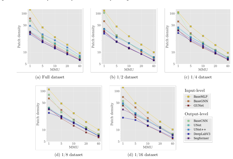
On the paper's own terms, the discovery is that imposing a minimum mapping unit through segments acts as a regularizer rather than a constraint: across nearly all tested models and data sizes, enforcing the unit cut fragmentation substantially while overall accuracy stayed flat or improved, with the strongest models (GraphUNet and DeepLabV3) losing under one point at a 5-pixel unit while patch density dropped by about half. The paper further claims a clear division of labour between the two integration levels: output-level aggregation is the top performer on the full 342,330-patch dataset, whereas input-level aggregation is markedly more robust to data reduction—GUNet loses about 5% overall accuracy on a sixteenth of the data, against about 8% for DeepLabV3, and overtakes it as the best model in that regime. A third claim is that pre-trained features (a UPerNet-ResNet-152 extractor trained on ESA WorldCover pseudo-labels) lift small models to the accuracy of large segmentation networks—BaseMLP rising from 60.1% to 70.7% overall accuracy—and compress the full-to-one-sixteenth data penalty from roughly five points to about one. Finally, the best input- and output-level configurations outperform the ESRI-LC and ESA-WC products at their own fragmentation levels, which the authors attribute to the choice of graph transformer operator, Graclus-based pooling, and the region-adjacency graph design rather than to parameter count.
Load-bearing premise
The method assumes that every pixel inside one automatically drawn image segment really is the same land cover class, and this premise breaks down when segments grow large enough to swallow small parcels such as patches of woodland.
Editorial extensions
If this is right
- A 5-pixel minimum mapping unit roughly halves fragmentation (patch density) while costing the strongest models under one point of overall accuracy, so spatial coherence is nearly free at mild object sizes.
- With the full label set, output-level aggregation (DeepLabV3 with ResNet-34) leads; as training data shrinks toward one sixteenth, input-level aggregation (GraphUNet, BaseGNN) overtakes it, so the best integration level depends on survey density.
- Features from a pretrained model let small, cheap classifiers reach the accuracy of large segmentation networks and cut the data-reduction penalty from about five accuracy points to about one.
- Several LC-SLab configurations outperform the ESRI-LC and ESA-WC land cover products at their respective fragmentation levels while training only on LUCAS labels and annual composites, not millions of manually annotated pixels.
- Under sparse supervision, architecture choice matters more than parameter count: heavier backbones (ResNet-50, MiT-B5) consistently did not help and sometimes hurt.
Reading between the lines
- The same recipe—oversegmentation plus pretrained features plus a small graph classifier—is poised to transfer to data-scarce regions such as sub-Saharan Africa, where the paper notes land cover products are weakest; the one-sixteenth-data results suggest the framework is engineered for exactly that regime, although the evaluation is exclusively European.
- A testable extension the authors leave implicit is replacing the fixed-cost oversegmentation with a learned or foundation-model segmentation so that the same-class object assumption adapts to the actual parcel pattern rather than a preset minimum segment size.
- Plotting accuracy against patch density defines a Pareto frontier that turns the minimum mapping unit from a hyperparameter into a design target: any future land cover model could be scored by how far its curve sits from that frontier, making fragmentation comparisons quantitative rather than visual.
- Because the authors flag annual composites as a limitation, a direct test is whether the object-based advantage survives added temporal detail—monthly composites could sharpen object boundaries and could alter the ranking between input- and output-level aggregation.
Signed reviews
Editorial analysis
A structured set of objections, weighed in public.
Referee Report
Summary. The paper introduces LC-SLab, a framework for object-based deep learning land cover classification from Sentinel-2 composites with sparse LUCAS labels. It compares input-level aggregation (graph neural networks on oversegmentation objects) with output-level aggregation (semantic segmentation models followed by logit averaging over objects), optionally using features from a pretrained UPerNet/ResNet-152 that was trained on ESA-WC pseudo-labels. Experiments cover seven model families, five minimum mapping units (1, 5, 10, 20, 40 px), five dataset sizes (full, 1/2, 1/4, 1/8, 1/16), and three seeds. The main claims are that object-based methods match or exceed pixel-wise accuracy while producing substantially more coherent maps; that input-level aggregation is more robust on small datasets while output-level aggregation performs best on full data; that pretrained features improve small models; and that several LC-SLab configurations outperform ESA-WC and ESRI-LC.
Significance. If the results hold, the paper provides a systematic, large-scale comparison of object-based deep learning strategies under sparse supervision, a practically relevant setting. Strengths include the breadth of the experimental matrix (7 model families x 5 MMUs x 5 dataset sizes x 3 seeds), transparent reporting of means and standard deviations, the use of partial cross-entropy for sparse labels, and consistency between the prose and the appendix tables. The paper also ships a reproducible pipeline (code/data promised) and makes falsifiable ranking claims. However, the central 'accuracy while more coherent' claim is weakened by the fact that accuracy is measured only at sparse point labels while fragmentation is measured on the full patch, and by the absence of a simple smoothing baseline. These issues are fixable within the manuscript's scope.
major comments (3)
- [Section 2.3.1, Section 2.1.1, Section 3.1] The sparse-point evaluation creates a systematic bias in favor of object-based methods. Accuracy is computed at only one random pixel per 64x64 patch (Section 2.2.4), while object-based methods assign a single label to an entire FH segment. When the purity assumption of Section 2.1.1 is violated, the sampled pixel can be correct while the majority of the object is wrong; the paper itself acknowledges this at MMU=40px in Section 3.1. Because the accuracy metrics are not supported by dense reference data, the reported accuracy-fragmentation tradeoff (Figures 4/5) may be an artifact of the scoring protocol rather than a genuine property of the produced maps. I recommend adding a dense-reference validation (e.g., a hold-out set with full dense labels or an independent dense product) or, at minimum, reporting object-purity statistics and corresponding map-level accuracy bounds.
- [Section 2.1.4, Section 3.1] The output-level aggregation is essentially averaging logits per segment, yet the paper does not compare against a simple non-learning baseline that enforces the same MMU (e.g., a pixel-wise segmentation followed by majority vote within each FH segment). Without this baseline, the reader cannot attribute the observed coherence improvements to the object-based deep learning components rather than to the MMU enforcement itself. Adding such a baseline would clarify the framework's contribution and is directly testable with the existing pipeline.
- [Section 2.2.3, Section 2.4, Section 3.4] The comparison against ESA-WC is confounded by a temporal mismatch: ESA-WC is a 2020 product while the evaluation labels and Sentinel-2 composites are from 2018. The same ESA-WC product is also used to generate pseudo-labels for pretraining the feature extractor (Section 2.4), so the feature-extraction improvements in Section 3.3 and the product comparison in Section 3.4 both depend on an acknowledged temporal gap. The paper notes the mismatch but does not quantify its impact. I recommend time-matching the comparison (e.g., using a 2018 product or ESA-WC 2019) or performing a sensitivity analysis to show that the reported advantages persist when the temporal gap is taken into account.
minor comments (5)
- [Section 2.1.3] The sentence about not computing variability and geometric features when learned feature maps are used is unclear; please specify exactly which node features are used in the +PT experiments and whether the mean intensity is still included.
- [Appendix A] The table headers (e.g., 'Overall accuracy F1 score Patch density Edge density Entropy t=0 t=1 t=0 t=1') are misaligned in the current formatting; please use proper multi-level column headers for t=0 and t=1 under each metric.
- [Section 2.2.4 and Section 2.4] The paper trains with labels placed at least 5px from the border and then excludes the 5px border from evaluation; please clarify the reason for this exclusion and state whether the fragmentation metrics are also computed on the reduced evaluation area.
- [Section 3.1] The claim that patch density is 'decreased by about half while the accuracy suffers by less than 1%' would benefit from a direct reference to the corresponding rows in Table Appendix A.1, to facilitate verification.
- [Data Availability] The statement 'All code and data will be made publicly available upon acceptance' could be strengthened by including a persistent repository DOI or a targeted release date in the final version.
Circularity Check
No significant circularity: the empirical claims are evaluated against held-out LUCAS labels and are not forced by construction.
full rationale
LC-SLab is an empirical benchmarking paper; its central claims are that object-based methods achieve comparable accuracy to pixel-wise models with lower fragmentation, and that input-level aggregation is preferable with small datasets while output-level aggregation is preferable with more data. These claims rest on measurements of overall accuracy/F1 against held-out LUCAS point labels (Sections 2.2.4, 2.3.1, 3.1) and on fragmentation metrics computed from the produced maps (Section 2.3.2). No parameter is fitted to those same accuracy numbers and then reported as a prediction: classifiers are optimized with partial cross-entropy on sparse LUCAS labels, and the reported metrics are evaluated on the separate test split. The only mild signal is that the feature extractor is pretrained on ESA-WC pseudo-labels (Section 2.4) while ESA-WC is also used as a benchmark product (Section 2.2.3), but the final training and accuracy evaluation are against LUCAS labels, and the third-party comparison in Section 3.4 explicitly uses the raw-intensity GUNet and DeepLabV3 models, not the pretrained-feature configurations. The self-citations to Leonhardt and Roscher [26] and ClimSat [63] describe prior dataset iterations and architecture inspiration only; they are not load-bearing support for the current results. Thus no step in the paper's derivation chain reduces to its own inputs by construction.
Assumptions & free parameters
assumptions (4)
- domain assumption All pixels assigned to the same FH oversegmentation object belong to the same land cover class.
- domain assumption LUCAS in-situ labels are accurate and are valid ground truth for the land cover class at the corresponding pixel.
- domain assumption Annual Sentinel-2 composites (25th percentile of unmasked pixels) preserve the spectral information needed to distinguish LUCAS land cover classes.
- domain assumption The pretrained feature extractor is trained on ESA-WC pseudo-labels and can serve as a transferable feature source for LUCAS-based classification.
Cite this review
Pith. "Pith review of LC-SLab -- An object-based deep learning framework for large-scale land cover classification from satellite imagery and sparse in-situ labels." pith.science (2026). https://pith.science/paper/WYWTIKQ4
@misc{pith2026250915868,
  author       = {Pith},
  title        = {Pith review of: LC-SLab -- An object-based deep learning framework for large-scale land cover classification from satellite imagery and sparse in-situ labels},
  year         = {2026},
  howpublished = {\url{https://pith.science/paper/WYWTIKQ4}},
  note         = {Machine review of arXiv:2509.15868}
}
read the original abstract
Large-scale land cover maps generated using deep learning play a critical role across a wide range of Earth science applications. Open in-situ datasets from principled land cover surveys offer a scalable alternative to manual annotation for training such models. However, their sparse spatial coverage often leads to fragmented and noisy predictions when used with existing deep learning-based land cover mapping approaches. A promising direction to address this issue is object-based classification, which assigns labels to semantically coherent image regions rather than individual pixels, thereby imposing a minimum mapping unit. Despite this potential, object-based methods remain underexplored in deep learning-based land cover mapping pipelines, especially in the context of medium-resolution imagery and sparse supervision. To address this gap, we propose LC-SLab, the first deep learning framework for systematically exploring object-based deep learning methods for large-scale land cover classification under sparse supervision. LC-SLab supports both input-level aggregation via graph neural networks, and output-level aggregation by postprocessing results from established semantic segmentation models. Additionally, we incorporate features from a large pre-trained network to improve performance on small datasets. We evaluate the framework on annual Sentinel-2 composites with sparse LUCAS labels, focusing on the tradeoff between accuracy and fragmentation, as well as sensitivity to dataset size. Our results show that object-based methods can match or exceed the accuracy of common pixel-wise models while producing substantially more coherent maps. Input-level aggregation proves more robust on smaller datasets, whereas output-level aggregation performs best with more data. Several configurations of LC-SLab also outperform existing land cover products, highlighting the framework's practical utility.
Figures


Figures from the paper (7 more)



Reference graph
Works this paper leans on
-
[1]
J. R. G. Townshend, Land cover, International Jour- nal of Remote Sensing 13 (6-7) (1992) 1319–1328. doi:10.1080/01431169208904193
-
[2]
M. A. Wulder, N. C. Coops, D. P. Roy, J. C. White, T. Hermosilla, Land cover 2.0, International Jour- nal of Remote Sensing 39 (12) (2018) 4254–4284. doi:10.1080/01431161.2018.1452075
arXiv 2018
-
[3]
V . C. Radeloff, D. P. Roy, M. A. Wulder, M. An- derson, B. Cook, C. J. Crawford, M. Friedl, F. Gao, N. Gorelick, M. Hansen, S. Healey, P. Hostert, G. Hul- ley, J. L. Huntington, D. M. Johnson, C. Neigh, A. Lyapustin, L. Lymburner, N. Pahlevan, J.-F. Pekel, T. A. Scambos, C. Schaaf, P. Strobl, C. E. Wood- cock, H. K. Zhang, Z. Zhu, Need and vision for glo...
arXiv 2024
-
[4]
X. X. Zhu, D. Tuia, L. Mou, G.-S. Xia, L. Zhang, F. Xu, F. Fraundorfer, Deep Learning in Remote Sensing: A Comprehensive Review and List of Resources, IEEE Geo- science and Remote Sensing Magazine 5 (4) (2017) 8–36. doi:10.1109/MGRS.2017.2762307
arXiv 2017
-
[5]
L. Ma, Y . Liu, X. Zhang, Y . Ye, G. Yin, B. A. Johnson, Deep learning in remote sensing applications: A meta-analysis and review, ISPRS Journal of Pho- togrammetry and Remote Sensing 152 (2019) 166–177. doi:10.1016/j.isprsjprs.2019.04.015
-
[6]
Kotaridis, M
I. Kotaridis, M. Lazaridou, Remote sensing image seg- mentation advances: A meta-analysis, ISPRS Journal of Photogrammetry and Remote Sensing 173 (2021) 309–
2021
-
[7]
N. Zang, Y . Cao, Y . Wang, B. Huang, L. Zhang, P. T. Mathiopoulos, Land-Use Mapping for High-Spatial Res- olution Remote Sensing Image Via Deep Learning: A Re- view, IEEE Journal of Selected Topics in Applied Earth Observations and Remote Sensing 14 (2021) 5372–5391. doi:10.1109/JSTARS.2021.3078631
arXiv 2021
-
[8]
Alemohammad, K
H. Alemohammad, K. Booth, LandCoverNet: A global benchmark land cover classification training dataset, in: AI for Earth Sciences Workshop at NeurIPS, 2020
2020
Show all 83 references
-
[9]
Koller, M
C. Koller, M. Shahrad, X. X. Zhu, Uncertainty- Guided Representation Learning in Local Climate Zone Classification, in: International Geoscience and Remote Sensing Symposium, 2022, pp. 183–186. doi:10.1109/IGARSS46834.2022.9883897
2022
-
[11]
Fritz, I
S. Fritz, I. McCallum, C. Schill, C. Perger, L. See, D. Schepaschenko, M. van der Velde, F. Kraxner, M. Obersteiner, Geo-Wiki: An online platform for improving global land cover, Environmen- tal Modelling & Software 31 (2012) 110–123. doi:10.1016/j.envsoft.2011.11.015
2012 doi
-
[12]
Fritz, L
S. Fritz, L. See, C. Perger, I. McCallum, C. Schill, D. Schepaschenko, M. Duerauer, M. Karner, C. Dresel, J.-C. Laso-Bayas, M. Lesiv, I. Moorthy, C. F. Salk, O. Danylo, T. Sturn, F. Albrecht, L. You, F. Kraxner, M. Obersteiner, A global dataset of crowdsourced land cover and l...
2017 doi
-
[13]
Conrad, A
C. Conrad, A. Goessl, S. Lex, A. Metz, T. Esch, C. Kon- rad, G. Goettlicher, S. Dech, Mapping crop distribution in administrative districts of southwest Germany using multi-sensor remote sensing data, in: Remote Sensing for Agriculture, Ecosystems, and Hydrology, V ol. 7824, S...
2010 doi
-
[14]
B. Mack, P. Leinenkugel, C. Kuenzer, S. Dech, A semi-automated approach for the generation of a new land use and land cover product for Ger- many based on Landsat time-series and Lucas in-situ data, Remote Sensing Letters 8 (3) (2017) 244–253. doi:10.1080/2150704X.2016.1249299. 13
2017
-
[15]
Weigand, J
M. Weigand, J. Staab, M. Wurm, H. Taubenböck, Spa- tial and semantic effects of LUCAS samples on fully automated land use/land cover classification in high- resolution Sentinel-2 data, International Journal of Ap- plied Earth Observation and Geoinformation 88 (2020) 102065. do...
2020
-
[16]
Pflugmacher, A
D. Pflugmacher, A. Rabe, M. Peters, P. Hostert, Map- ping pan-European land cover using Landsat spectral- temporal metrics and the European LUCAS survey, Re- mote Sensing of Environment 221 (2019) 583–595. doi:10.1016/j.rse.2018.12.001
2019 doi
-
[17]
S. M. Mirmazloumi, M. Kakooei, F. Mohseni, A. Ghor- banian, M. Amani, M. Crosetto, O. Monserrat, ELULC- 10, a 10 m European Land Use and Land Cover Map Using Sentinel and Landsat Data in Google Earth Engine, Remote Sensing 14 (13) (2022) 3041. doi:10.3390/rs14133041
2022 doi
-
[18]
d’Andrimont, A
R. d’Andrimont, A. Verhegghen, G. Lemoine, P. Kem- peneers, M. Meroni, M. van der Velde, From parcel to continental scale – A first European crop type map based on Sentinel-1 and LUCAS Copernicus in-situ ob- servations, Remote Sensing of Environment 266 (2021) 112708. doi:10.1...
2021
-
[19]
Ghassemi, E
B. Ghassemi, E. Izquierdo-Verdiguier, A. Verhegghen, M. Yordanov, G. Lemoine, Á. Moreno Martínez, D. De Marchi, M. van der Velde, F. Vuolo, R. d’Andrimont, European Union crop map 2022: Earth observation’s 10-meter dive into Europe’s crop tapestry, Scientific Data 11 (1) (2024...
2024 doi
-
[20]
LeCun, B
Y . LeCun, B. Boser, J. S. Denker, D. Henderson, R. E. Howard, W. Hubbard, L. D. Jackel, Back- propagation Applied to Handwritten Zip Code Recog- nition, Neural Computation 1 (4) (1989) 541–551. doi:10.1162/neco.1989.1.4.541
1989 doi
-
[21]
Dosovitskiy, L
A. Dosovitskiy, L. Beyer, A. Kolesnikov, D. Weissenborn, X. Zhai, T. Unterthiner, M. Dehghani, M. Minderer, G. Heigold, S. Gelly, J. Uszkoreit, N. Houlsby, An Image is Worth 16x16 Words: Transformers for Image Recog- nition at Scale, in: International Conference on Learning Re...
2021
-
[22]
Kussul, M
N. Kussul, M. Lavreniuk, S. Skakun, A. Shelestov, Deep Learning Classification of Land Cover and Crop Types Using Remote Sensing Data, IEEE Geoscience and Remote Sensing Letters 14 (5) (2017) 778–782. doi:10.1109/LGRS.2017.2681128
2017
-
[23]
Karra, C
K. Karra, C. Kontgis, Z. Statman-Weil, J. C. Mazzariello, M. Mathis, S. P. Brumby, Global land use/land cover with Sentinel 2 and deep learning, in: International Geoscience and Remote Sensing Symposium, 2021, pp. 4704–4707. doi:10.1109/IGARSS47720.2021.9553499
2021
-
[24]
C. F. Brown, S. P. Brumby, B. Guzder-Williams, T. Birch, S. B. Hyde, J. Mazzariello, W. Czerwinski, V . J. Pasquarella, R. Haertel, S. Ilyushchenko, K. Schwehr, M. Weisse, F. Stolle, C. Hanson, O. Guinan, R. Moore, A. M. Tait, Dynamic World, Near real-time global 10 m land use...
2022
-
[25]
Galatola, E
M. Galatola, E. Arnaudo, L. Barco, C. Rossi, F. Do- minici, Land Cover Segmentation with Sparse Annota- tions from Sentinel-2 Imagery, in: International Geo- science and Remote Sensing Symposium, 2023, pp. 6952–6955. doi:10.1109/IGARSS52108.2023.10281933
2023
-
[26]
Leonhardt, R
J. Leonhardt, R. Roscher, Sparsely labeled land cover classification with oversegmentation-based Graph UNets, in: Machine Learning for Remote Sensing Workshop at ICLR, 2024
2024
-
[27]
Sharma, R
S. Sharma, R. Sedona, M. Riedel, G. Cavallaro, C. Paris, Sen4Map: Advancing Mapping With Sentinel- 2 by Providing Detailed Semantic Descriptions and Customizable Land-Use and Land-Cover Data, IEEE Journal of Selected Topics in Applied Earth Obser- vations and Remote Sensing 17...
2024
-
[28]
Saura, Effects of minimum mapping unit on land cover data spatial configuration and composition, International Journal of Remote Sensing 23 (22) (2002) 4853–4880
S. Saura, Effects of minimum mapping unit on land cover data spatial configuration and composition, International Journal of Remote Sensing 23 (22) (2002) 4853–4880. doi:10.1080/01431160110114493
2002 doi
-
[29]
García-Álvarez, M
D. García-Álvarez, M. T. Camacho Olmedo, M. Paegelow, Sensitivity of a common Land Use Cover Change (LUCC) model to the Minimum Mapping Unit (MMU) and Minimum Mapping Width (MMW) of input maps, Computers, En- vironment and Urban Systems 78 (2019) 101389. doi:10.1016/j.compenvu...
2019
-
[30]
Blaschke, Object based image analysis for re- mote sensing, ISPRS Journal of Photogramme- try and Remote Sensing 65 (1) (2010) 2–16
T. Blaschke, Object based image analysis for re- mote sensing, ISPRS Journal of Photogramme- try and Remote Sensing 65 (1) (2010) 2–16. doi:10.1016/j.isprsjprs.2009.06.004
2010 doi
-
[31]
Blaschke, G
T. Blaschke, G. J. Hay, M. Kelly, S. Lang, P. Hofmann, E. Addink, R. Queiroz Feitosa, F. van der Meer, H. van der Werff, F. van Coillie, D. Tiede, Geographic Object- Based Image Analysis – Towards a new paradigm, IS- PRS Journal of Photogrammetry and Remote Sensing 87 (2014) 1...
2014 doi
-
[32]
L. Ma, Z. Yan, M. Li, T. Liu, L. Tan, X. Wang, W. He, R. Wang, G. He, H. Lu, T. Blaschke, Deep Learning Meets Object-Based Image Analysis: Tasks, challenges, strategies, and perspectives, IEEE Geoscience and Remote Sensing Magazine (2024) 2– 30doi:10.1109/MGRS.2024.3489952. 14
2024
-
[33]
Q. Diao, Y . Dai, C. Zhang, Y . Wu, X. Feng, F. Pan, Superpixel-Based Attention Graph Neural Network for Semantic Segmentation in Aerial Images, Remote Sens- ing 14 (2) (2022) 305. doi:10.3390/rs14020305
2022 doi
-
[34]
W. Zhao, S. Peng, J. Chen, R. Peng, Contextual-Aware Land Cover Classification With U-Shaped Object Graph Neural Network, IEEE Geoscience and Remote Sensing Letters 19 (2022) 1–5. doi:10.1109/LGRS.2022.3177778
2022
-
[35]
Kavran, D
D. Kavran, D. Mongus, B. Žalik, N. Luka ˇc, Graph Neu- ral Network-Based Method of Spatiotemporal Land Cover Mapping Using Satellite Imagery, Sensors 23 (14) (2023)
2023
-
[36]
S. Liu, Z. Qi, X. Li, A. G.-O. Yeh, Integration of Convolutional Neural Networks and Object-Based Post- Classification Refinement for Land Use and Land Cover Mapping with Optical and SAR Data, Remote Sensing 11 (6) (2019) 690. doi:10.3390/rs11060690
2019 doi
-
[37]
L. Mi, Z. Chen, Superpixel-enhanced deep neural for- est for remote sensing image semantic segmentation, IS- PRS Journal of Photogrammetry and Remote Sensing 159 (2020) 140–152. doi:10.1016/j.isprsjprs.2019.11.006
2020 doi
-
[38]
Timilsina, J
S. Timilsina, J. Aryal, J. B. Kirkpatrick, Mapping Ur- ban Tree Cover Changes Using Object-Based Convolu- tion Neural Network (OB-CNN), Remote Sensing 12 (18) (2020) 3017. doi:10.3390/rs12183017
2020 doi
-
[39]
Ienco, R
D. Ienco, R. Gaetano, R. Interdonato, K. Ose, D. Ho Tong Minh, Combining Sentinel-1 and Sentinel- 2 Time Series via RNN for Object-Based Land Cover Classification, in: International Geoscience and Re- mote Sensing Symposium, 2019, pp. 4881–4884. doi:10.1109/IGARSS.2019.8898458
2019
-
[40]
P. F. Felzenszwalb, D. P. Huttenlocher, Efficient Graph-Based Image Segmentation, International Jour- nal of Computer Vision 59 (2) (2004) 167–181. doi:10.1023/B:VISI.0000022288.19776.77
2004
-
[41]
Zhuang, Z
F. Zhuang, Z. Qi, K. Duan, D. Xi, Y . Zhu, H. Zhu, H. Xiong, Q. He, A Comprehensive Survey on Transfer Learning, Proceedings of the IEEE 109 (1) (2021) 43–76. doi:10.1109/JPROC.2020.3004555
2021
-
[42]
T. Xiao, Y . Liu, B. Zhou, Y . Jiang, J. Sun, Unified Per- ceptual Parsing for Scene Understanding, in: European Conference on Computer Vision, 2018, pp. 418–434
2018
-
[43]
R. A. Cosma, L. Knobel, P. van der Linden, D. M. Knigge, E. J. Bekkers, Geometric Superpixel Rep- resentations for Efficient Image Classification with Graph Neural Networks, in: International Conference on Computer Vision Workshops, 2023, pp. 109–118. doi:10.1109/ICCVW60793.2023.00018
2023
-
[44]
H. Gao, S. Ji, Graph U-Nets, in: International Conference on Machine Learning, PMLR, 2019, pp. 2083–2092
2019
-
[45]
H. Gao, S. Ji, Graph U-Nets, IEEE Transactions on Pat- tern Analysis and Machine Intelligence 44 (9) (2022) 4948–4960. doi:10.1109/TPAMI.2021.3081010
2022
-
[46]
I. S. Dhillon, Y . Guan, B. Kulis, Weighted Graph Cuts without Eigenvectors A Multilevel Approach, IEEE Transactions on Pattern Analysis and Ma- chine Intelligence 29 (11) (2007) 1944–1957. doi:10.1109/TPAMI.2007.1115
2007
-
[47]
B. O. Fagginger Auer, R. H. Bisseling, A GPU Algorithm for Greedy Graph Matching, in: R. Keller, D. Kramer, J.-P. Weiss (Eds.), Facing the Multicore - Challenge II: Aspects of New Paradigms and Technologies in Parallel Computing, Springer, Berlin, Heidelberg, 2012, pp. 108–
2012
-
[48]
T. N. Kipf, M. Welling, Semi-Supervised Classification with Graph Convolutional Networks, in: International Conference on Learning Representations, 2017
2017
-
[49]
Hamilton, Z
W. Hamilton, Z. Ying, J. Leskovec, Inductive Representa- tion Learning on Large Graphs, in: Conference on Neural Information Processing Systems, V ol. 30, Curran Asso- ciates, Inc., 2017
2017
-
[50]
Veli ˇckovi´c, G
P. Veli ˇckovi´c, G. Cucurull, A. Casanova, A. Romero, P. Liò, Y . Bengio, Graph Attention Networks, in: Inter- national Conference on Learning Representations, 2018
2018
-
[51]
S. Yun, M. Jeong, R. Kim, J. Kang, H. J. Kim, Graph transformer networks, in: Conference on Neural Informa- tion Processing Systems, V ol. 32, Curran Associates, Inc., 2019
2019
-
[52]
Y . Shi, Z. Huang, S. Feng, H. Zhong, W. Wang, Y . Sun, Masked Label Prediction: Unified Message Passing Model for Semi-Supervised Classification, in: Interna- tional Joint Conference on Artificial Intelligence, V ol. 2, 2021, pp. 1548–1554. doi:10.24963/ijcai.2021/214
2021 doi
-
[53]
Ronneberger, P
O. Ronneberger, P. Fischer, T. Brox, U-Net: Convolu- tional Networks for Biomedical Image Segmentation, in: N. Navab, J. Hornegger, W. M. Wells, A. F. Frangi (Eds.), Medical Image Computing and Computer-Assisted In- tervention, 2015, pp. 234–241. doi:10.1007/978-3-319- 24574-4_28
2015 doi
-
[54]
Z. Zhou, M. M. Rahman Siddiquee, N. Tajbakhsh, J. Liang, UNet++: A Nested U-Net Architecture for Med- ical Image Segmentation, in: D. Stoyanov, Z. Taylor, G. Carneiro, T. Syeda-Mahmood, A. Martel, L. Maier- Hein, J. M. R. Tavares, A. Bradley, J. P. Papa, V . Bela- giannis, J. ...
2018
-
[55]
L.-C. Chen, G. Papandreou, I. Kokkinos, K. Murphy, A. L. Yuille, DeepLab: Semantic Image Segmentation with Deep Convolutional Nets, Atrous Convolution, and Fully Connected CRFs, IEEE Transactions on Pattern Analysis and Machine Intelligence 40 (4) (2018) 834–
2018
- [56]
-
[57]
E. Xie, W. Wang, Z. Yu, A. Anandkumar, J. M. Alvarez, P. Luo, SegFormer: Simple and Efficient Design for Se- mantic Segmentation with Transformers, in: Conference on Neural Information Processing Systems, V ol. 34, Cur- ran Associates, Inc., 2021, pp. 12077–12090
2021
-
[58]
Çiçek, A
Ö. Çiçek, A. Abdulkadir, S. S. Lienkamp, T. Brox, O. Ronneberger, 3D U-Net: Learning Dense V olumetric Segmentation from Sparse Annotation, in: S. Ourselin, L. Joskowicz, M. R. Sabuncu, G. Unal, W. Wells (Eds.), Medical Image Computing and Computer-Assisted Inter- vention, Lec...
2016 doi
-
[59]
M. Tang, A. Djelouah, F. Perazzi, Y . Boykov, C. Schroers, Normalized Cut Loss for Weakly-Supervised CNN Seg- mentation, in: Conference on Computer Vision and Pat- tern Recognition, 2018, pp. 1818–1827
2018
-
[60]
Bokhovkin, E
A. Bokhovkin, E. Burnaev, Boundary Loss for Remote Sensing Imagery Semantic Segmentation, in: H. Lu, H. Tang, Z. Wang (Eds.), International Symposium on Neural Networks, Springer International Publishing, Cham, 2019, pp. 388–401. doi:10.1007/978-3-030- 22808-8_38
2019 doi
-
[61]
Y . Hua, D. Marcos, L. Mou, X. X. Zhu, D. Tuia, Semantic Segmentation of Remote Sensing Images With Sparse An- notations, IEEE Geoscience and Remote Sensing Letters 19 (2022) 1–5. doi:10.1109/LGRS.2021.3051053
2022
-
[62]
Liang, T
Z. Liang, T. Wang, X. Zhang, J. Sun, J. Shen, Tree En- ergy Loss: Towards Sparsely Annotated Semantic Seg- mentation, in: Conference on Computer Vision and Pat- tern Recognition, 2022, pp. 16907–16916
2022
-
[63]
Leonhardt, J
J. Leonhardt, J. Gall, R. Roscher, ClimSat – A diffusion autoencoder model for climate-conditional satellite image editing, Science of Remote Sensing 11 (2025) 100235. doi:10.1016/j.srs.2025.100235
2025
-
[64]
Zanaga, R
D. Zanaga, R. Van De Kerchove, W. De Keersmaecker, N. Souverijns, C. Brockmann, R. Quast, J. Wevers, A. Grosu, A. Paccini, S. Vergnaud, O. Cartus, M. San- toro, S. Fritz, I. Georgieva, M. Lesiv, S. Carter, M. Herold, L. Li, N.-E. Tsendbazar, F. Ramoino, O. Arino, ESA WorldCove...
2021 doi
-
[65]
Z. S. Venter, D. N. Barton, T. Chakraborty, T. Simensen, G. Singh, Global 10 m Land Use Land Cover Datasets: A Comparison of Dynamic World, World Cover and Esri Land Cover, Remote Sensing 14 (16) (2022) 4101. doi:10.3390/rs14164101
2022 doi
-
[66]
Xu, N.-E
P. Xu, N.-E. Tsendbazar, M. Herold, S. de Bruin, M. Koopmans, T. Birch, S. Carter, S. Fritz, M. Lesiv, E. Mazur, A. Pickens, P. Potapov, F. Stolle, A. Tyukav- ina, R. Van De Kerchove, D. Zanaga, Comparative vali- dation of recent 10 m-resolution global land cover maps, Remote ...
2024
-
[67]
Kerner, C
H. Kerner, C. Nakalembe, A. Yang, I. Zvonkov, R. McWeeny, G. Tseng, I. Becker-Reshef, How ac- curate are existing land cover maps for agriculture in Sub-Saharan Africa?, Scientific Data 11 (1) (2024) 486. doi:10.1038/s41597-024-03306-z
2024 doi
-
[68]
M. G. Turner, R. H. Gardner, Landscape Metrics, in: M. G. Turner, R. H. Gardner (Eds.), Landscape Ecology in Theory and Practice: Pattern and Process, Springer, New York, NY , 2015, pp. 97–142. doi:10.1007/978-1-4939- 2794-4_4
2015 doi
-
[69]
Paszke, S
A. Paszke, S. Gross, F. Massa, A. Lerer, J. Bradbury, G. Chanan, T. Killeen, Z. Lin, N. Gimelshein, L. Antiga, A. Desmaison, A. Kopf, E. Yang, Z. DeVito, M. Rai- son, A. Tejani, S. Chilamkurthy, B. Steiner, L. Fang, J. Bai, S. Chintala, PyTorch: An Imperative Style, High- Perf...
2019
-
[70]
M. Fey, J. E. Lenssen, Fast Graph Representation Learn- ing with PyTorch Geometric, in: Representation Learning on Graphs and Manifolds Workshop at ICLR, 2019
2019
- [71]
-
[72]
van der Walt, J
S. van der Walt, J. L. Schönberger, J. Nunez-Iglesias, F. Boulogne, J. D. Warner, N. Yager, E. Gouillart, T. Yu, Scikit-image: Image processing in Python, PeerJ 2 (2014) e453. doi:10.7717/peerj.453
2014 doi
-
[73]
N. S. Detlefsen, J. Borovec, J. Schock, A. H. Jha, T. Koker, L. D. Liello, D. Stancl, C. Quan, M. Grechkin, W. Falcon, TorchMetrics - Measuring Reproducibility in PyTorch, Journal of Open Source Software 7 (70) (2022)
2022
-
[74]
Gorelick, M
N. Gorelick, M. Hancher, M. Dixon, S. Ilyushchenko, D. Thau, R. Moore, Google Earth Engine: 16 Planetary-scale geospatial analysis for everyone, Re- mote Sensing of Environment 202 (2017) 18–27. doi:10.1016/j.rse.2017.06.031
2017 doi
-
[75]
Jakubik, S
J. Jakubik, S. Roy, C. E. Phillips, P. Fraccaro, D. God- win, B. Zadrozny, D. Szwarcman, C. Gomes, G. Nyir- jesy, B. Edwards, D. Kimura, N. Simumba, L. Chu, S. K. Mukkavilli, D. Lambhate, K. Das, R. Bangalore, D. Oliveira, M. Muszynski, K. Ankur, M. Ramasubrama- nian, I. Gurun...
-
[76]
Jakubik, F
J. Jakubik, F. Yang, B. Blumenstiel, E. Scheurer, R. Se- dona, S. Maurogiovanni, J. Bosmans, N. Dionelis, V . Marsocci, N. Kopp, R. Ramachandran, P. Frac- caro, T. Brunschwiler, G. Cavallaro, J. Bernabe- Moreno, N. Longépé, TerraMind: Large-Scale Gen- erative Multimodality for...
- [77]
-
[78]
Kirillov, E
A. Kirillov, E. Mintun, N. Ravi, H. Mao, C. Rolland, L. Gustafson, T. Xiao, S. Whitehead, A. C. Berg, W.-Y . Lo, P. Dollar, R. Girshick, Segment Anything, in: Interna- tional Conference on Computer Vision, 2023, pp. 4015– 4026. 17 Appendix A. Supplementary material for Section...
2023
-
[119]
doi:10.1007/978-3-642-30397-5_10
-
[251]
doi:10.1038/s41597-022-01307-4
-
[322]
doi:10.1016/j.isprsjprs.2021.01.020
2021 doi
-
[848]
doi:10.1109/TPAMI.2017.2699184
2017
-
[4101]
doi:10.21105/joss.04101
-
[6648]
doi:10.3390/s23146648
Reviewed August 15, 2026 · model on record in the stance chip above.
Discussion (0). Continue with ORCID to comment.