Swarical: An Integrated Hierarchical Approach to Localizing Flying Light Specks
Pith reviewed 2026-05-25 02:10 UTC · model grok-4.3
The pith
Swarical lets swarms of flying light specks localize themselves as accurately as prior methods but more than twice as fast.
A machine-rendered reading of the paper's core claim, the machinery that carries it, and where it could break.
Core claim
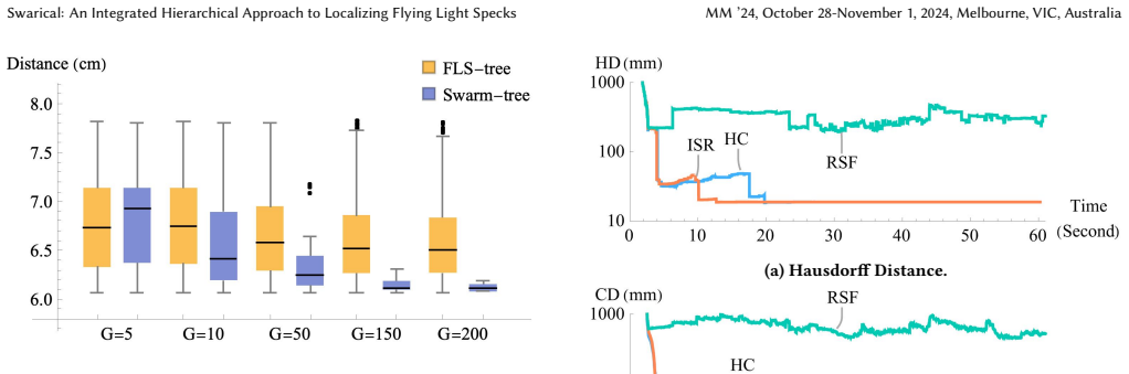
Swarical is an integrated hierarchical approach that enables a swarm of Flying Light Specks to localize accurately and efficiently. Accuracy is set by the physical sensors that track neighboring FLSs, and the method converts mesh files into point clouds that let the swarm reach the highest accuracy those sensors allow. It incorporates a heterogeneous mix of FLSs with differing sensor orientations to guarantee line of sight between a localizing FLS and its anchor FLS. The Raspberry-camera and ArUco-marker implementation demonstrates that Swarical is as accurate as a state-of-the-art decentralized technique yet more than 2x faster.
What carries the argument
Swarical, the swarm-based hierarchical localization technique that converts mesh files to point clouds using hardware specifications and heterogeneous sensor orientations to ensure line of sight.
If this is right
- Swarms reach the accuracy ceiling set by their own hardware when illuminating complex 2D and 3D shapes.
- Localization finishes in less than half the time of comparable decentralized methods.
- Heterogeneous sensor orientations become a practical design choice for maintaining visibility inside the swarm.
- Mesh-to-point-cloud conversion lets designers directly map target shapes to the swarm's localization capability.
- An implementation with standard cameras and markers shows the approach works on readily available hardware.
Where Pith is reading between the lines
- The hierarchical structure may reduce total communication volume as swarm size grows compared with fully decentralized tracking.
- The same sensor-orientation principle could apply to other mobile robot groups that need mutual visibility for coordination.
- Testing the method while shapes move or while FLSs enter and leave the swarm would reveal how robust the line-of-sight guarantee remains.
- Pairing Swarical with existing path-planning algorithms could produce end-to-end systems that both localize and illuminate without extra layers of control.
Load-bearing premise
The sensors on each flying light speck can track neighbors with enough precision and a mix of sensor orientations will always keep a line of sight open between a localizing unit and its anchor.
What would settle it
A controlled test in which all FLSs share the same sensor orientation, producing blocked line-of-sight cases and either lower localization accuracy or no speed gain over the decentralized baseline.
Figures


read the original abstract
Swarical, a Swarm-based hierarchical localization technique, enables miniature drones, known as Flying Light Specks (FLSs), to accurately and efficiently localize and illuminate complex 2D and 3D shapes. Its accuracy depends on the physical hardware (sensors) of FLSs, which are used to track neighboring FLSs in order to localize themselves. It uses the hardware specification to convert mesh files into point clouds that enable a swarm of FLSs to localize at the highest accuracy afforded by their hardware. Swarical considers a heterogeneous mix of FLSs with different orientations for their tracking sensors, ensuring a line of sight between a localizing FLS and its anchor FLS. We present an implementation using Raspberry cameras and ArUco markers. A comparison of Swarical with a state of the art decentralized localization technique shows that it is as accurate and more than 2x faster.
Editorial analysis
A structured set of objections, weighed in public.
Referee Report
Summary. The paper presents Swarical, a swarm-based hierarchical localization technique for Flying Light Specks (FLSs) that converts mesh files to point clouds using hardware sensor specifications to achieve localization at the precision limit of the sensors. It incorporates a heterogeneous mix of FLS orientations to ensure line-of-sight to anchor FLSs and reports an implementation using Raspberry Pi cameras and ArUco markers. The central empirical claim is that Swarical matches the accuracy of a state-of-the-art decentralized localization technique while providing more than 2x speedup.
Significance. If the accuracy and speedup claims are substantiated with full experimental validation, the work could contribute a hardware-aware hierarchical method for swarm localization in illumination applications, directly tying sensor limits to point-cloud generation.
major comments (2)
- [Abstract] Abstract: the performance comparison result ('as accurate and more than 2x faster') is stated without any accompanying experimental details, error bars, dataset descriptions, statistical tests, or sensitivity analysis to sensor noise, preventing verification of whether the 2x speedup and accuracy equivalence hold.
- [Abstract and implementation description] The manuscript states that accuracy depends on physical sensors and that heterogeneous orientations ensure line of sight, yet provides no separate quantification of tracking error under flight dynamics, no failure-rate measurements when orientations vary, and no analysis showing how localization error scales with sensor noise; these unquantified assumptions are load-bearing for both the accuracy and speedup claims.
minor comments (1)
- Clarify early in the manuscript how the mesh-to-point-cloud conversion step interacts with the hierarchical swarm structure.
Simulated Author's Rebuttal
We thank the referee for the detailed and constructive feedback. We address each major comment below, indicating revisions where the manuscript can be strengthened without misrepresenting the presented work.
read point-by-point responses
-
Referee: [Abstract] Abstract: the performance comparison result ('as accurate and more than 2x faster') is stated without any accompanying experimental details, error bars, dataset descriptions, statistical tests, or sensitivity analysis to sensor noise, preventing verification of whether the 2x speedup and accuracy equivalence hold.
Authors: We agree that the abstract is concise and omits these specifics, which are instead reported in the evaluation section of the full manuscript (including dataset descriptions, error bars on accuracy and runtime measurements, and direct comparison to the decentralized baseline). To improve verifiability at a glance, we will revise the abstract to incorporate a brief summary of the experimental conditions, the number of trials, and the observed speedup factor with its variability. revision: yes
-
Referee: [Abstract and implementation description] The manuscript states that accuracy depends on physical sensors and that heterogeneous orientations ensure line of sight, yet provides no separate quantification of tracking error under flight dynamics, no failure-rate measurements when orientations vary, and no analysis showing how localization error scales with sensor noise; these unquantified assumptions are load-bearing for both the accuracy and speedup claims.
Authors: The accuracy equivalence and speedup results are obtained from controlled experiments using the specified Raspberry Pi cameras and ArUco markers under the heterogeneous orientation configuration described in the method. These results directly support the claims for the evaluated scenarios. The manuscript does not include separate dynamic-flight error quantification, orientation-failure rates, or explicit sensor-noise scaling curves; we will add a limitations paragraph discussing these assumptions and their potential impact on generalization. revision: partial
Circularity Check
No circularity: empirical implementation and comparison with no fitted predictions or self-referential derivations
full rationale
The paper describes a hierarchical localization system that directly consumes hardware sensor specifications to generate point clouds from meshes and relies on heterogeneous sensor orientations plus ArUco tracking for line-of-sight. The central claim is an empirical result (accuracy parity with >2x speedup versus a decentralized baseline). No equations, parameter fitting, predictions derived from fitted inputs, or derivation chains appear in the provided text. The accuracy statement is conditioned on external hardware properties rather than being defined in terms of the method's own outputs. No self-citations are invoked as load-bearing uniqueness theorems. This is a standard systems/implementation paper whose results are falsifiable via replication on the stated hardware; the derivation chain is therefore self-contained against external benchmarks.
Axiom & Free-Parameter Ledger
axioms (2)
- domain assumption FLS sensors can track neighboring FLSs with accuracy sufficient for the claimed localization performance
- domain assumption Heterogeneous sensor orientations guarantee line-of-sight between localizing and anchor FLSs
Reference graph
Works this paper leans on
-
[1]
Hamed Alimohammadzadeh, Rohit Bernard, Yang Chen, Trung Phan, Prashant Singh, Shuqin Zhu, Heather Culbertson, and Shahram Ghandeharizadeh. 2023. Dronevision: An Experimental 3D Testbed for Flying Light Specks. InThe First International Conference on Holodecks (Los Angeles, California)(Holodecks ’23) . Mitra LLC, Los Angeles, CA, USA, 1–9. https://doi.org/...
-
[2]
Hamed Alimohammadzadeh, Heather Culbertson, and Shahram Ghande- harizadeh. 2023. An Evaluation of Decentralized Group Formation Techniques for Flying Light Specks. InACM Multimedia Asia (Taipei, Taiwan)
work page 2023
-
[3]
Hamed Alimohammadzadeh and Shahram Ghandeharizadeh. 2023. SwarMer: A Decentralized Localization Framework for Flying Light Specks. InThe First International Conference on Holodecks (Los Angeles, California)(Holodecks ’23) . Mitra LLC, Los Angeles, CA, USA, 10–22. https://doi.org/10.61981/ZFSH2302
-
[4]
Hamed Alimohammadzadeh, Daryon Mehraban, and Shahram Ghande- harizadeh. 2023. Modeling Illumination Data with Flying Light Specks. InACM Multimedia Systems (Vancouver, Canada)(MMSys ’23). Association for Comput- ing Machinery, New York, NY, USA, 363–368. https://doi.org/10.1145/3587819. 3592544
-
[5]
Hamed Alimohammadzadeh, Shuqin Zhu, Jiadong Bai, and Shahram Ghande- harizadeh. 2024. Reliability Groups with Standby Flying Light Specks. InACM Multimedia Systems (Bari, Italy)
work page 2024
-
[6]
Martin Brossard, Axel Barrau, and Silvère Bonnabel. 2020. AI-IMU Dead- Reckoning. IEEE Transactions on Intelligent Vehicles 5, 4 (2020), 585–595. https: //doi.org/10.1109/TIV.2020.2980758
- [7]
-
[8]
Yang Chen, Hamed Alimohammadzadeh, Heather Culbertson, and Shahram Ghandeharizadeh. 2023. Towards a Stable 3D Physical Human-Drone Interac- tion. InThe First International Conference on Holodecks (Los Angeles, California) (Holodecks ’23) . Mitra LLC, Los Angeles, CA, USA, 34–37. https://doi.org/10. 61981/ZFSH2308
work page 2023
-
[9]
Yang Chen, Hamed Alimohammadzadeh, Shahram Ghandeharizadeh, and Heather Culbertson. 2024. Force-Feedback Through Touch-based Interactions With A Nanocopter. In IEEE Symposium on Haptics (Long Beach, California) (Haptics ’24). IEEE, Long Beach, CA, USA, 7 pages
work page 2024
-
[10]
Pablo Corbalán, Gian Pietro Picco, and Sameera Palipana. 2019. Chorus: UWB Concurrent Transmissions for GPS-like Passive Localization of Countless Tar- gets. In Proceedings of the 18th International Conference on Information Process- ing in Sensor Networks (Montreal, Quebec, Canada)(IPSN ’19) . Association for Computing Machinery, New York, NY, USA, 133–1...
-
[11]
Massimiliano Corsini, Paolo Cignoni, and Roberto Scopigno. 2012. Efficient and Flexible Sampling with Blue Noise Properties of Triangular Meshes.IEEE Trans- actions on Visualization and Computer Graphics 18, 6 (2012), 914–924. https: //doi.org/10.1109/TVCG.2012.34
-
[12]
H. Fan, H. Su, and L. Guibas. 2017. A Point Set Generation Network for 3D Object Reconstruction from a Single Image. In2017 IEEE Conference on Computer Vision and Pattern Recognition (CVPR). IEEE Computer Society, Los Alamitos, CA, USA, 2463–2471. https://doi.org/10.1109/CVPR.2017.264
-
[13]
S. Garrido-Jurado, R. Muñoz-Salinas, F.J. Madrid-Cuevas, and M.J. Marín- Jiménez. 2014. Automatic Generation and Detection of Highly Reliable Fidu- cial Markers under Occlusion. Pattern Recognition 47, 6 (2014), 2280–2292. https://doi.org/10.1016/j.patcog.2014.01.005
-
[14]
Shahram Ghandeharizadeh. 2021. Holodeck: Immersive 3D Displays Using Swarms of Flying Light Specks. InACM Multimedia Asia (Gold Coast, Australia). ACM Press, New York, NY, 1–7. https://doi.org/10.1145/3469877.3493698
-
[15]
Shahram Ghandeharizadeh. 2022. Display of 3D Illuminations using Flying Light Specks. In ACM Multimedia. ACM Press, New York, NY, 2996–3005
work page 2022
-
[16]
Shahram Ghandeharizadeh and Vincent Oria. 2023. Virtual Reality, Augmented Reality, Mixed Reality, Holograms and Holodecks. InThe First International Con- ference on Holodecks (Los Angeles, California)(Holodecks ’23) . Mitra LLC, Los Angeles, CA, USA, 38–40. https://doi.org/10.61981/ZFSH2304
-
[17]
Francisco Javier Gonzalez-Castano, Felipe Gil-Castineira, David Rodriguez- Pereira, Jose Angel Regueiro-Janeiro, Silvia Garcia-Mendez, and David Candal- Ventureira. 2020. Self-corrective Sensor Fusion for Drone Positioning in Indoor Facilities.IEEE Access 9 (2020), 2415–2427
work page 2020
-
[18]
D.P. Huttenlocher, G.A. Klanderman, and W.J. Rucklidge. 1993. Comparing Im- ages Using the Hausdorff Distance.IEEE Transactions on Pattern Analysis and Machine Intelligence 15, 9 (1993), 850–863. https://doi.org/10.1109/34.232073
-
[19]
David R. Karger, Philip N. Klein, and Robert E. Tarjan. 1995. A Randomized Linear-Time Algorithm to Find Minimum Spanning Trees.J. ACM 42, 2 (mar 1995), 321–328. https://doi.org/10.1145/201019.201022
-
[20]
Alex Kushleyev, Daniel Mellinger, Caitlin Powers, and Vijay Kumar. 2013. To- wards a Swarm of Agile Micro Quadrotors. Autonomous Robots 35 (11 2013), 573–7527. https://doi.org/10.1007/s10514-013-9349-9
-
[21]
S. Lloyd. 1982. Least Squares Quantization in PCM.IEEE Transactions on Infor- mation Theory 28, 2 (1982), 129–137. https://doi.org/10.1109/TIT.1982.1056489
-
[22]
K Nirmal, AG Sreejith, Joice Mathew, Mayuresh Sarpotdar, Ambily Suresh, Ajin Prakash, Margarita Safonova, and Jayant Murthy. 2016. Noise Modeling and Analysis of an IMU-based Attitude Sensor: Improvement of Performance by Fil- tering and Sensor Fusion. InAdvances in optical and mechanical technologies for telescopes and instrumentation II , Vol. 9912. SPI...
work page 2016
-
[23]
Michael Norman, Vince Kellen, Shava Smallen, Brian DeMeulle, Shawn Strande, Ed Lazowska, Naomi Alterman, Rob Fatland, Sarah Stone, Amanda Tan, Kather- ine Yelick, Eric Van Dusen, and James Mitchell. 2021. CloudBank: Managed Services to Simplify Cloud Access for Computer Science Research and Educa- tion. InPractice and Experience in Advanced Research Compu...
-
[24]
Trung Phan, Hamed Alimohammadzadeh, Heather Culbertson, and Shahram Ghandeharizadeh. 2023. An Evaluation of Three Distance Measurement Tech- nologies for Flying Light Specks. InInternational Conference on Intelligent Meta- verse Technologies and Applications (iMETA2023) (Tartu, Estonia)
work page 2023
- [25]
-
[26]
Müller, Markus Hehn, and Raffaello D’Andrea
Robin Ritz, Mark W. Müller, Markus Hehn, and Raffaello D’Andrea. 2012. Co- operative Quadrocopter Ball Throwing and Catching. In2012 IEEE/RSJ Interna- tional Conference on Intelligent Robots and Systems . 4972–4978. https://doi.org/ 10.1109/IROS.2012.6385963
-
[27]
Nel Samama. 2008. Global Positioning: Technologies and Performance . https: //doi.org/10.1002/9780470241912
-
[28]
K. Siwiak. 2001. Ultra-wide Band Radio: Introducing a New Technology. In IEEE VTS 53rd Vehicular Technology Conference, Spring 2001. Proceedings (Cat. No.01CH37202), Vol. 2. 1088–1093 vol.2. https://doi.org/10.1109/VETECS.2001. 944546
-
[29]
Janis Tiemann and Christian Wietfeld. 2017. Scalable and Precise Multi-UA V Indoor Navigation using TDOA-based UWB Localization. In2017 international conference on indoor positioning and indoor navigation (IPIN) . IEEE, 1–7
work page 2017
-
[30]
Jiang Wang and William J Wilson. 1992. 3D Relative Position and Orientation Estimation using Kalman Filter for Robot Control. InProceedings 1992 IEEE Inter- national Conference on Robotics and Automation . IEEE Computer Society, 2638– 2639
work page 1992
-
[31]
Zong-Sheng Wang, Jung Lee, Chang Geun Song, and Sun-Jeong Kim. 2020. Data- Driven Point Sampling with Blue-noise Properties for Triangular Meshes. InPro- ceedings of the 3rd International Conference on Computer Science and Software Engineering (Beijing, China)(CSSE ’20). Association for Computing Machinery, New York, NY, USA, 77–82. https://doi.org/10.114...
-
[32]
Brian White, Jay Lepreau, Leigh Stoller, Robert Ricci, Shashi Guruprasad, Mac Newbold, Mike Hibler, Chad Barb, and Abhijeet Joglekar. 2002. An Integrated Experimental Environment for Distributed Systems and Networks.SIGOPS Oper. Syst. Rev. 36, SI, 255–270. https://doi.org/10.1145/844128.844152 MM ’24, October 28-November 1, 2024, Melbourne, VIC, Australia...
-
[33]
Seong-hoon Peter Won, Wael William Melek, and Farid Golnaraghi. 2009. a Kalman/Particle Filter-based Position and Orientation Estimation Method using a Position Sensor/Inertial Measurement Unit Hybrid System.IEEE Transactions on Industrial Electronics 57, 5 (2009), 1787–1798
work page 2009
-
[34]
Hao Xu, Luqi Wang, Yichen Zhang, Kejie Qiu, and Shaojie Shen. 2020. Decentral- ized Visual-Inertial-UWB Fusion for Relative State Estimation of Aerial Swarm. In 2020 IEEE international conference on robotics and automation (ICRA) . IEEE, 8776–8782
work page 2020
-
[35]
Dong-Ming Yan, Jian-Wei Guo, Bin Wang, Xiao-Peng Zhang, and Peter Wonka
-
[36]
A Survey of Blue-Noise Sampling and Its Applications.Journal of Computer Science and Technology 30, 3 (2015), 439–452
work page 2015
-
[37]
Nima Yazdani, Hamed Alimohammadzadeh, and Shahram Ghandeharizadeh
-
[38]
In The First International Conference on Holodecks (Los An- geles, California) (Holodecks ’23)
A Conceptual Model of Intelligent Multimedia Data Rendered using Fly- ing Light Specks. In The First International Conference on Holodecks (Los An- geles, California) (Holodecks ’23) . Mitra LLC, Los Angeles, CA, USA, 38–44. https://doi.org/10.61981/ZFSH2309
-
[39]
Shuqin Zhu and Shahram Ghandeharizadeh. 2023. Flight Patterns for Swarms of Drones. InThe First International Conference on Holodecks (Los Angeles, Cal- ifornia)(Holodecks ’23) . Mitra LLC, Los Angeles, CA, USA, 29–33. https://doi. org/10.61981/ZFSH2303
discussion (0)
Sign in with ORCID, Apple, or X to comment. Anyone can read and Pith papers without signing in.