Biomazon: A Multimodal Dataset for 3D Forest Structure and Biomass Modeling in the Amazon Basin
Pith reviewed 2026-06-28 06:00 UTC · model grok-4.3
The pith
Biomazon supplies a 20 m multimodal benchmark that pairs full GEDI RH profiles and AGBD with multi-sensor inputs for joint forest-structure modeling in the Amazon.
A machine-rendered reading of the paper's core claim, the machinery that carries it, and where it could break.
Core claim
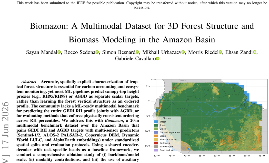
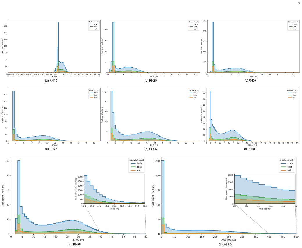
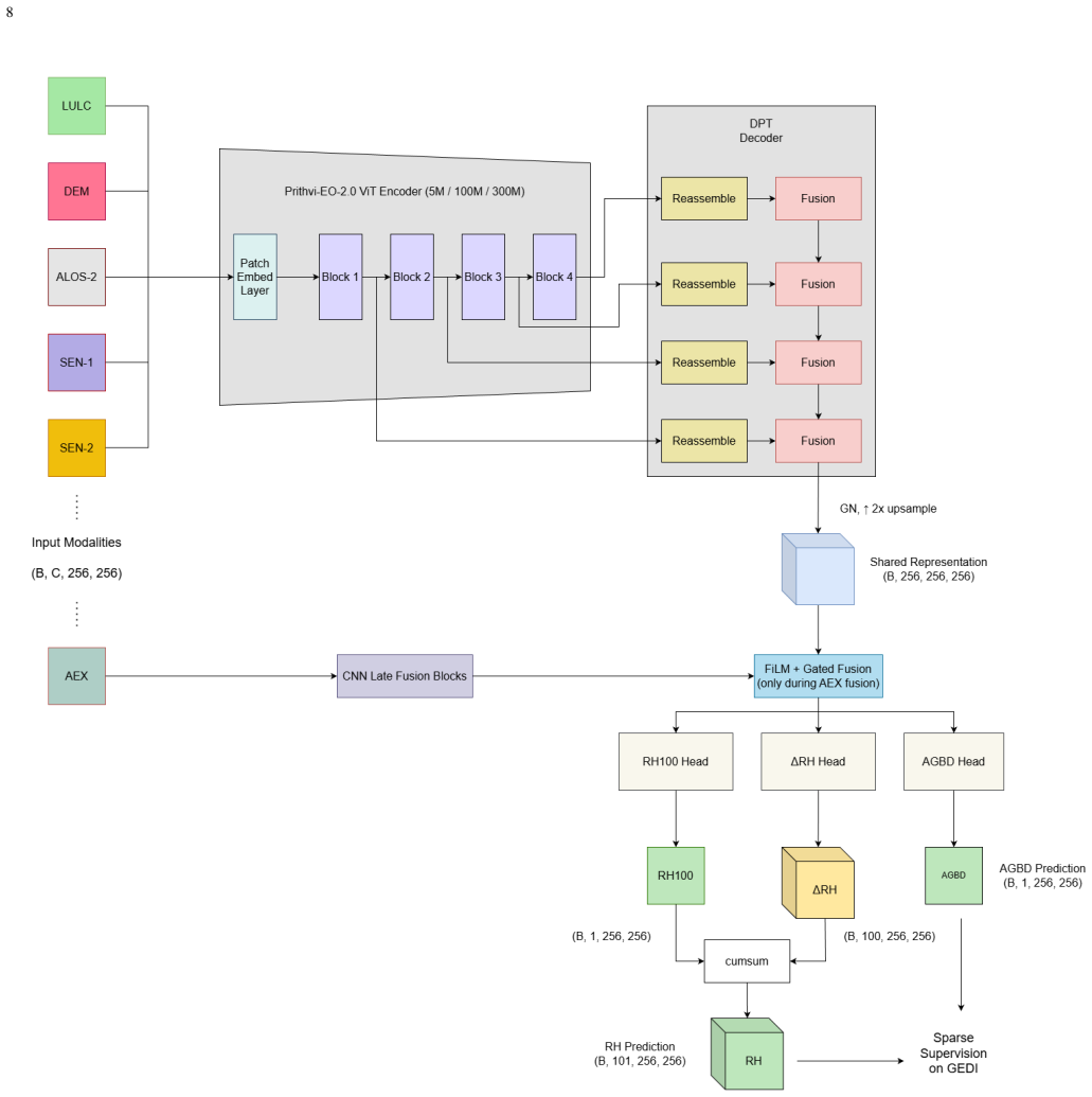
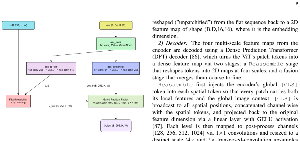
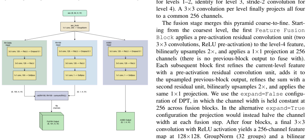
Biomazon is a 20 m multimodal benchmark dataset over the Amazon Basin that pairs GEDI RH and AGBD targets with multi-sensor predictors including Sentinel-1/2, ALOS-2 PALSAR-2, Copernicus DEM, Dynamic World LULC, and AlphaEarth embeddings, under standardized spatial splits and evaluation protocols, enabling joint prediction of the entire RH profile with AGBD.
What carries the argument
The Biomazon dataset with its GEDI targets and multi-sensor inputs under fixed splits, used as the central benchmark for evaluating joint RH-profile and AGBD prediction methods.
If this is right
- Allows comprehensive ablation of model scale, modality contributions, and auxiliary embeddings in standalone and fusion settings.
- Reports single-target and joint-target results under a unified training protocol to quantify tradeoffs.
- Provides regionally aligned comparisons against existing GEDI L4D RH10-RH98 and AGBD products at matching temporal scale.
- Establishes a reference benchmark for future work on structurally consistent RH-profile prediction and structure-biomass modeling in tropical forests.
Where Pith is reading between the lines
- Joint modeling of the full profile may reduce biomass estimation errors by enforcing physically consistent ordering across RH percentiles.
- The dataset could support extensions to other tropical regions once similar GEDI pairings become available.
- Standardized protocols may allow direct comparison of new methods against the reported baselines without re-implementing splits.
Load-bearing premise
The chosen multi-sensor predictors and standardized spatial splits produce an ML-ready benchmark without leakage or regional bias.
What would settle it
A demonstration that models trained on Biomazon show large performance drops on held-out regions or no gain over models trained on prior datasets without the full multimodal stack would falsify its value as a robust benchmark.
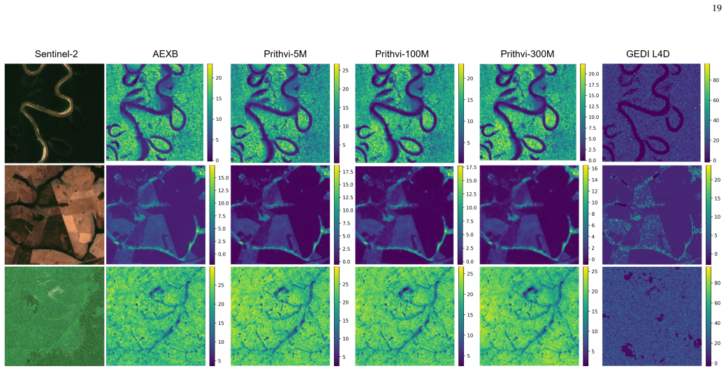
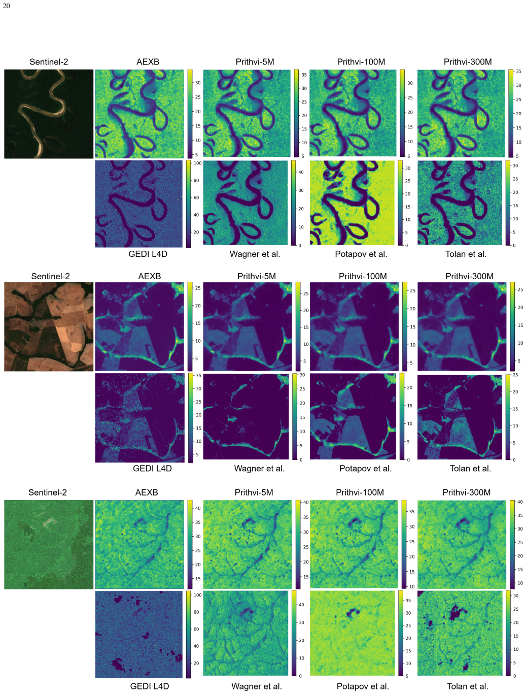
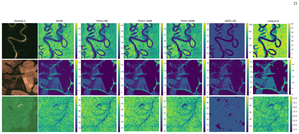
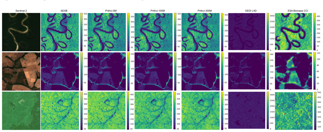
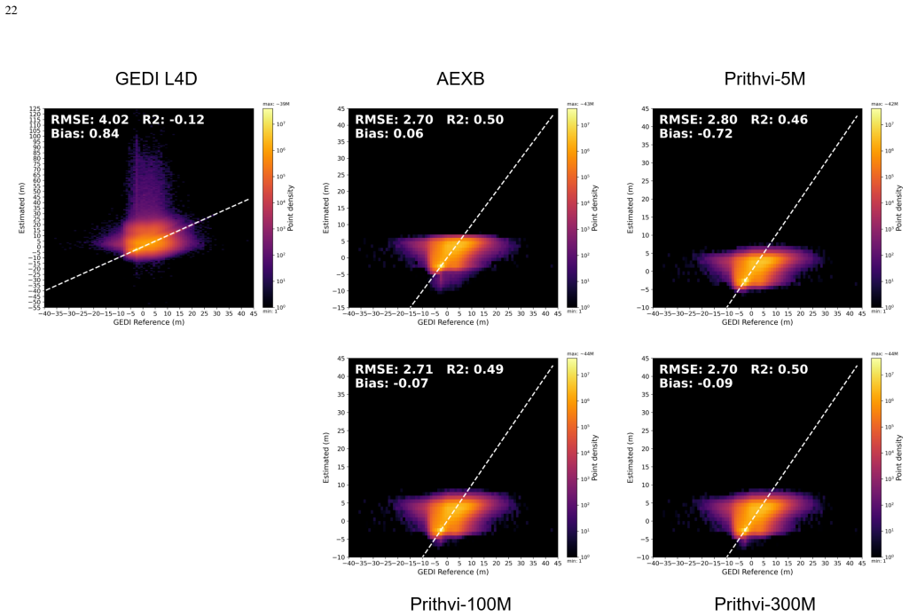
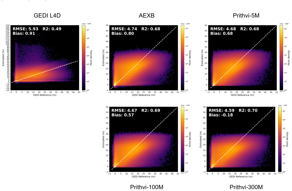
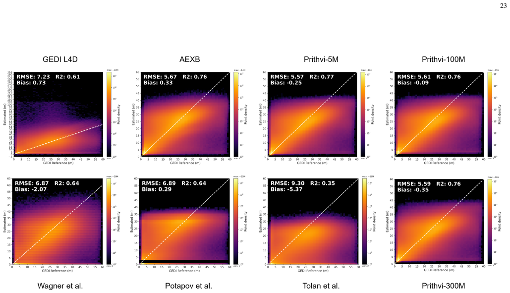
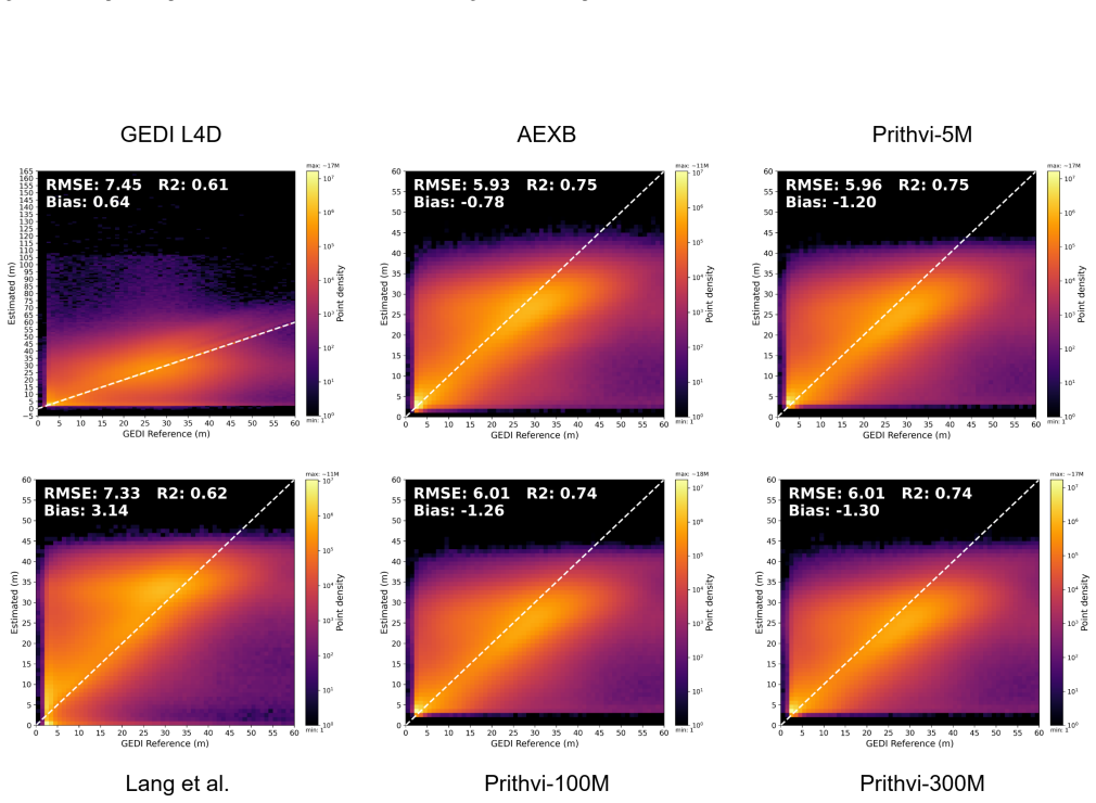
Figures
read the original abstract
Accurate, spatially explicit characterization of tropical forest structure is essential for carbon accounting and ecosystem monitoring, yet most ML pipelines predict canopy-top height proxies (e.g., RH95/RH98) or AGBD as separate scalar targets, rather than learning the forest vertical structure as an ordered profile. The community lacks a ML-ready multimodal benchmark for predicting the entire GEDI RH profile jointly with AGBD, or for evaluating methods that enforce physically consistent ordering across RH percentiles. We address this with Biomazon, a 20 m multimodal benchmark dataset over the Amazon Basin that pairs GEDI RH and AGBD targets with multi-sensor predictors (Sentinel-1/2, ALOS-2 PALSAR-2, Copernicus DEM, Dynamic World LULC, and AlphaEarth embeddings) under standardized spatial splits and evaluation protocols. Using a shared encoder-decoder with task-specific heads as a baseline framework, we conduct a comprehensive ablation study of (i) backbone/model scale, (ii) modality contributions, and (iii) the use of auxiliary embeddings under standalone and fusion settings, and we report both single-target and joint-target results to quantify tradeoffs under a unified training protocol. Finally, we contextualize baseline performance through regionally aligned comparisons against existing gridded products, including GEDI L4D RH10-RH98 and AGBD, at matching temporal scale. Biomazon, together with the accompanying protocols and baseline results, establishes a reference benchmark for future work on structurally consistent RH-profile prediction and structure-biomass modeling in tropical forests.
Editorial analysis
A structured set of objections, weighed in public.
Referee Report
Summary. The manuscript introduces Biomazon, a 20 m resolution multimodal dataset over the Amazon Basin that pairs GEDI RH profiles and AGBD targets with multi-sensor predictors (Sentinel-1/2, ALOS-2 PALSAR-2, Copernicus DEM, Dynamic World LULC, AlphaEarth embeddings). It supplies standardized spatial splits and evaluation protocols, together with baseline encoder-decoder experiments that ablate backbone scale, modality contributions, auxiliary embeddings, and single- versus joint-target training, plus comparisons to existing gridded GEDI L4D products.
Significance. If the spatial splits demonstrably eliminate leakage, Biomazon would supply a needed public benchmark for methods that predict ordered RH profiles jointly with AGBD while enforcing physical consistency, moving the field beyond separate scalar height or biomass regressions.
major comments (1)
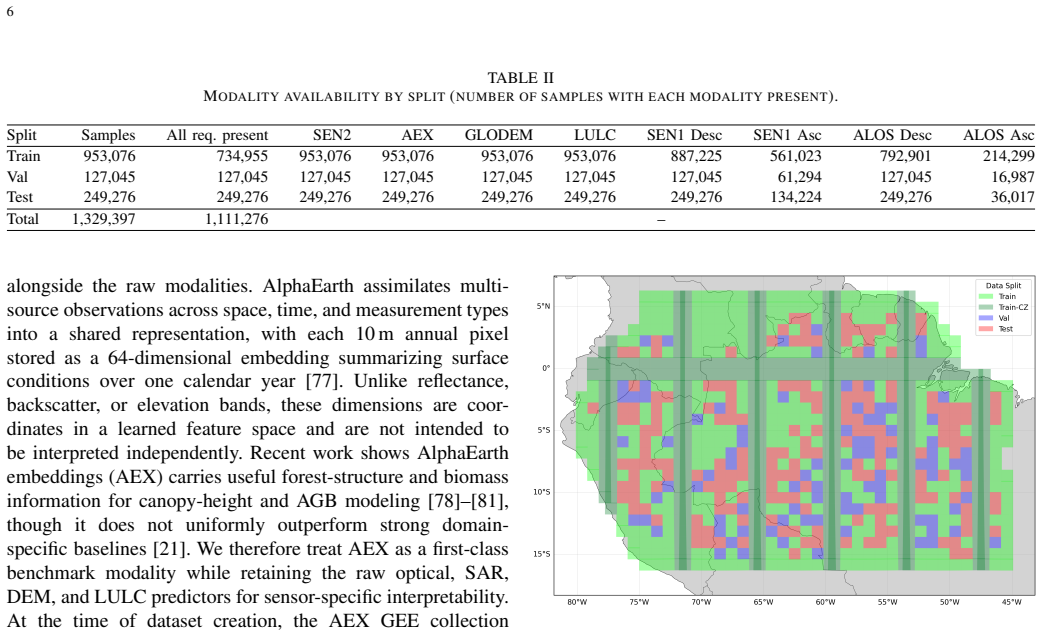
- [Methods] Methods (spatial split description): the manuscript states that standardized spatial splits are provided but supplies no block size, minimum separation distance, or stratification method. In the Amazon, where forest structure and Sentinel/ALOS signatures exhibit autocorrelation lengths of several km, splits that are merely “spatial” rather than explicitly block-cross-validated at scales exceeding predictor correlation length leave the central claim of an ML-ready, leakage-free benchmark unsubstantiated.
Simulated Author's Rebuttal
We thank the referee for the constructive feedback emphasizing the need for explicit details on spatial splitting to substantiate the leakage-free benchmark claim. We agree this aspect requires clarification and will revise the manuscript to address it directly.
read point-by-point responses
-
Referee: [Methods] Methods (spatial split description): the manuscript states that standardized spatial splits are provided but supplies no block size, minimum separation distance, or stratification method. In the Amazon, where forest structure and Sentinel/ALOS signatures exhibit autocorrelation lengths of several km, splits that are merely “spatial” rather than explicitly block-cross-validated at scales exceeding predictor correlation length leave the central claim of an ML-ready, leakage-free benchmark unsubstantiated.
Authors: We acknowledge that the manuscript currently lacks explicit details on block size, minimum separation distance, and stratification method for the spatial splits. This omission weakens the substantiation of the leakage-free claim, particularly given the autocorrelation scales of several km for forest structure and multi-sensor predictors in the Amazon. In the revised manuscript, we will expand the Methods section (and associated data documentation) to specify: (i) the block size selected to exceed typical predictor correlation lengths, (ii) the minimum separation distance enforced between training and test blocks, and (iii) the stratification approach (e.g., by ecoregion or canopy cover). We will also release the exact splitting code and metadata to enable independent verification. These additions will directly support the central claim of an ML-ready benchmark. revision: yes
Circularity Check
Dataset release with baselines; no derivation chain present
full rationale
The paper releases a multimodal dataset (Biomazon) pairing GEDI targets with predictors under spatial splits and reports baseline ML experiments. No equations, fitted parameters, or first-principles derivations are claimed or present in the provided text. The central contribution is data curation and empirical benchmarking rather than any prediction that reduces to its inputs by construction. Self-citations, if any, are not load-bearing for a derivation. This matches the default non-circular case for dataset papers.
Axiom & Free-Parameter Ledger
Reference graph
Works this paper leans on
-
[1]
3d-abc: A foundation model for global terrestrial 3d above and below ground carbon stock mapping,
G. Grosse, J. Hashemi, L. van Delden, T. L ¨ubker, I. Nitze, J. Strauss, S. Kruse, U. Herzschuh, P. Ghamisi, P. Steinbach, G. Joshi, W. Yu, A. Rizaldy, R. Gloaguen, G. Cavallaro, E. Zandi, R. Sedona, S. Hashim, S. Mandal, M. Herold, Q. Song, S. Besnard, M. Urbazaev, M. Sips, A. Huth, I. Hajnsek, and M. Pardini, “3d-abc: A foundation model for global terre...
2025
-
[2]
J ¨ulich Supercomputing Centre, “JUWELS Cluster and Booster: Exascale Pathfinder with Modular Supercomputing Architecture at Juelich Supercomputing Centre,”Journal of large-scale research facilities, vol. 7, no. A183, 2021. [Online]. Available: http://dx.doi.org/ 10.17815/jlsrf-7-183
-
[3]
A large and persistent carbon sink in the world’s forests,
Y . Pan, R. A. Birdsey, J. Fang, R. Houghton, P. E. Kauppi, W. A. Kurz, O. L. Phillips, A. Shvidenko, S. L. Lewis, J. G. Canadell, P. Ciais, R. B. Jackson, S. W. Pacala, A. D. McGuire, S. Piao, A. Rautiainen, S. Sitch, and D. Hayes, “A large and persistent carbon sink in the world’s forests,”Science, vol. 333, no. 6045, pp. 988–993, 2011. [Online]. Availa...
-
[4]
Tropical forests are home to over half of the world’s vertebrate species,
R. Pillay, M. Venter, J. Aragon-Osejo, P. Gonz ´alez-del Pliego, A. J. Hansen, J. E. Watson, and O. Venter, “Tropical forests are home to over half of the world’s vertebrate species,”Frontiers in Ecology and the Environment, vol. 20, no. 1, pp. 10–15, 2022. [Online]. Available: https://esajournals.onlinelibrary.wiley.com/doi/abs/10.1002/fee.2420
-
[5]
Characterizing the structural complexity of the earth’s forests with spaceborne lidar,
T. de Conto, R. Dubayah, and J. Armston, “Characterizing the structural complexity of the earth’s forests with spaceborne lidar,” May 2024. [Online]. Available: http://dx.doi.org/10.21203/rs.3.rs-4445870/v1 27
-
[6]
Aboveground biomass density models for nasa’s global ecosystem dynamics investigation (gedi) lidar mission,
L. Duncanson, J. R. Kellner, J. Armston, R. Dubayah, D. M. Minor, S. Hancock, S. P. Healey, P. L. Patterson, S. Saarela, S. Marselis, C. E. Silva, J. Bruening, S. J. Goetz, H. Tang, M. Hofton, B. Blair, S. Luthcke, L. Fatoyinbo, K. Abernethy, A. Alonso, H.-E. Andersen, P. Aplin, T. R. Baker, N. Barbier, J. F. Bastin, P. Biber, P. Boeckx, J. Bogaert, L. Bo...
2022
-
[7]
Algorithm theoretical basis document for gedi footprint aboveground biomass density,
J. R. Kellner, J. Armston, and L. Duncanson, “Algorithm theoretical basis document for gedi footprint aboveground biomass density,” Earth and Space Science, vol. 10, no. 4, p. e2022EA002516, 2023, e2022EA002516 2022EA002516. [Online]. Available: https: //agupubs.onlinelibrary.wiley.com/doi/abs/10.1029/2022EA002516
-
[8]
The global ecosystem dynamics investigation: High-resolution laser ranging of the earth’s forests and topography,
R. Dubayah, J. B. Blair, S. Goetz, L. Fatoyinbo, M. Hansen, S. Healey, M. Hofton, G. Hurtt, J. Kellner, S. Luthcke, J. Armston, H. Tang, L. Duncanson, S. Hancock, P. Jantz, S. Marselis, P. L. Patterson, W. Qi, and C. Silva, “The global ecosystem dynamics investigation: High-resolution laser ranging of the earth’s forests and topography,” Science of Remote...
2020
-
[9]
A high- resolution canopy height model of the earth,
N. Lang, W. Jetz, K. Schindler, and J. D. Wegner, “A high- resolution canopy height model of the earth,”Nature Ecology & Evolution, vol. 7, no. 11, p. 1778–1789, 2023. [Online]. Available: http://dx.doi.org/10.1038/s41559-023-02206-6
-
[10]
Mapping global forest canopy height through integration of gedi and landsat data,
P. Potapov, X. Li, A. Hernandez-Serna, A. Tyukavina, M. C. Hansen, A. Kommareddy, A. Pickens, S. Turubanova, H. Tang, C. E. Silva, J. Armston, R. Dubayah, J. B. Blair, and M. Hofton, “Mapping global forest canopy height through integration of gedi and landsat data,”Remote Sensing of Environment, vol. 253, p. 112165, 2021. [Online]. Available: https://www....
2021
-
[11]
Dynamic world, near real-time global 10 m land use land cover mapping,
C. F. Brown, S. P. Brumby, B. Guzder-Williams, T. Birch, S. B. Hyde, J. Mazzariello, W. Czerwinski, V . J. Pasquarella, R. Haertel, S. Ilyushchenko, K. Schwehr, M. Weisse, F. Stolle, C. Hanson, O. Guinan, R. Moore, and A. M. Tait, “Dynamic world, near real-time global 10 m land use land cover mapping,” Scientific Data, vol. 9, no. 1, 2022. [Online]. Avail...
-
[12]
Species level mapping of forest canopy height in nepal using gedi with sentinel-1 and sentinel-2,
A. Nazir, N. P. Hanan, H. Gilani, and H. L. Shrestha, “Species level mapping of forest canopy height in nepal using gedi with sentinel-1 and sentinel-2,”Frontiers in Remote Sensing, vol. V olume 7 - 2026, 2026. [Online]. Available: https://www.frontiersin.org/journals/ remote-sensing/articles/10.3389/frsen.2026.1725509
-
[13]
Canopy height mapping in the western himalayas, pakistan: A deep learning approach using gedi and sentinel-2 fusion,
A. Ahmad, S. Sastry, A. Dhakal, S. Khanal, A. Levering, H. Gilani, and N. Jacobs, “Canopy height mapping in the western himalayas, pakistan: A deep learning approach using gedi and sentinel-2 fusion,”International Journal of Applied Earth Observation and Geoinformation, vol. 146, p. 105030, 2026. [Online]. Available: https://www.sciencedirect.com/science/...
2026
-
[14]
Satellite-based mapping of annual canopy height and aboveground biomass in african dense forests,
L. Wan, P. Ciais, A. de Truchis, E. Sean, F. J. Fischer, D. Purnell, G. Belouze, I. Fayad, M. Schwartz, Y . Xu, Y . Su, M. R ´ejou-M´echain, N. Barbier, P. Tresson, J.-F. Bastin, J. Bogaert, A. Vander Linden, A. Plumacker, B. Angoboy Ilondea, D.-M. Assumani, T. de Haulleville, L. B. Sagang, L. Durieux, Y . Ryu, T. Yang, C. V . Obame, T. Bossy, F. Frappart...
-
[15]
Mapping vegetation height and identifying the northern forest limit across canada using icesat-2, landsat time series and topographic data,
H. Travers-Smith, N. Coops, C. Mulverhill, M. Wulder, D. Ignace, and T. Lantz, “Mapping vegetation height and identifying the northern forest limit across canada using icesat-2, landsat time series and topographic data,”Remote Sensing of Environment, vol. 305, p. 114097, 2024. [Online]. Available: https://www.sciencedirect.com/science/article/pii/ S003442...
2024
-
[16]
Very high resolution canopy height maps from rgb imagery using self-supervised vision transformer and convolutional decoder trained on aerial lidar,
J. Tolan, H.-I. Yang, B. Nosarzewski, G. Couairon, H. V . V o, J. Brandt, J. Spore, S. Majumdar, D. Haziza, J. Vamaraju, T. Moutakanni, P. Bojanowski, T. Johns, B. White, T. Tiecke, and C. Couprie, “Very high resolution canopy height maps from rgb imagery using self-supervised vision transformer and convolutional decoder trained on aerial lidar,”Remote Se...
2024
-
[17]
F. H. Wagner, R. Dalagnol, G. Carter, M. C. M. Hirye, S. Gill, L. B. S. Takougoum, S. Favrichon, M. Keller, J. P. H. B. Ometto, L. Alves, C. Creze, S. P. George-Chacon, S. Li, Z. Liu, A. Mullissa, Y . Yang, E. G. Santos, S. R. Worden, M. Brandt, P. Ciais, S. C. Hagen, and S. Saatchi, “Wall-to-wall amazon forest height mapping with planet nicfi, aerial lid...
-
[18]
Gedi l2a elevation and height metrics data global footprint level v002,
R. Dubayah, M. Hofton, J. Blair, J. Armston, H. Tang, and S. Luthcke, “Gedi l2a elevation and height metrics data global footprint level v002,” 2021. [Online]. Available: https://www.earthdata.nasa.gov/data/ catalog/lpcloud-gedi02-a-002
2021
-
[19]
C. F. Brown, M. R. Kazmierski, V . J. Pasquarella, W. J. Rucklidge, M. Samsikova, C. Zhang, E. Shelhamer, E. Lahera, O. Wiles, S. Ilyushchenko, N. Gorelick, L. L. Zhang, S. Alj, E. Schechter, S. Askay, O. Guinan, R. Moore, A. Boukouvalas, and P. Kohli, “Alphaearth foundations: An embedding field model for accurate and efficient global mapping from sparse ...
Pith/arXiv arXiv 2025
-
[20]
Tessera: Temporal embeddings of surface spectra for earth representation and analysis,
Z. Feng, C. Atzberger, S. Jaffer, J. Knezevic, S. Sormunen, R. Young, M. C. Lisaius, M. Immitzer, T. Jackson, J. Ball, D. A. Coomes, A. Madhavapeddy, A. Blake, and S. Keshav, “Tessera: Temporal embeddings of surface spectra for earth representation and analysis,”
-
[21]
Available: https://arxiv.org/abs/2506.20380
[Online]. Available: https://arxiv.org/abs/2506.20380
-
[22]
Spectral indices outperform alphaearth foundation embeddings for aboveground biomass estimation in a regenerating tropical andean forest,
J. Rojas-Lucero, Y . Solano-Correa, N. Kolarik, J. Brandt, and T. Caughlin, “Spectral indices outperform alphaearth foundation embeddings for aboveground biomass estimation in a regenerating tropical andean forest,”Remote Sensing Applications: Society and Environment, vol. 42, p. 102113, 2026. [Online]. Available: https: //www.sciencedirect.com/science/ar...
2026
-
[23]
Open-canopy: Towards very high resolution forest monitor- ing,
F. Fogel, Y . Perron, N. Besic, L. Saint-Andr ´e, A. Pellissier-Tanon, M. Schwartz, T. Boudras, I. Fayad, A. d’Aspremont, L. Landrieu, and P. Ciais, “Open-canopy: Towards very high resolution forest monitor- ing,” in2025 IEEE/CVF Conference on Computer Vision and Pattern Recognition (CVPR), 2025, pp. 1395–1406
2025
-
[24]
H. Debary, M. Fiaz, and L. Klein, “Preditree: A multi-temporal sub-meter dataset of multi-spectral imagery aligned with canopy height maps,” 2025. [Online]. Available: https://arxiv.org/abs/2509.01202
arXiv 2025
-
[25]
Biomassters: A benchmark dataset for forest biomass estimation using multi-modal satellite time-series,
A. Nascetti, R. Yadav, K. Brodt, Q. Qu, H. Fan, Y . Shendryk, I. Shah, and C. Chung, “Biomassters: A benchmark dataset for forest biomass estimation using multi-modal satellite time-series,” inAdvances in Neural Information Processing Systems, A. Oh, T. Naumann, A. Globerson, K. Saenko, M. Hardt, and S. Levine, Eds., vol. 36. Curran Associates, Inc., 2023...
2023
-
[26]
Agbd: A global-scale biomass dataset,
G. Sialelli, T. Peters, J. D. Wegner, and K. Schindler, “Agbd: A global-scale biomass dataset,”ISPRS Annals of the Photogrammetry, Remote Sensing and Spatial Information Sciences, vol. X-G-2025, pp. 829–838, 2025. [Online]. Available: https://isprs-annals.copernicus.org/ articles/X-G-2025/829/2025/
2025
-
[27]
Gedi l4d imputed waveforms, version 2,
E. Seo, S. Healey, Z. Yang, R. Dubayah, T. De Conto, and J. Armston, “Gedi l4d imputed waveforms, version 2,” 2025, accessed: 2026-02-19. [Online]. Available: https://www.earthdata.nasa.gov/data/ catalog/ornl-cloud-gedi-l4d-imputed-waveforms-2455-2
2025
-
[28]
Santoro and O
M. Santoro and O. Cartus, “Esa biomass climate change initiative (biomass cci): Global datasets of forest above-ground biomass for the years 2007, 2010, 2015, 2016, 2017, 2018, 2019, 2020, 2021 and 2022, v6.0,” 2025. [Online]. Available: https://catalogue.ceda.ac. uk/uuid/95913ffb6467447ca72c4e9d8cf30501 28
2007
-
[29]
K. Ekaterina, H. Florian, M. St ´ephane, M. Florian, and P. Milena, “Super-resolved canopy height mapping from sentinel-2 time series using lidar hd reference data across metropolitan france,” 2025. [Online]. Available: http://dx.doi.org/10.2139/ssrn.5917615
-
[30]
Sera-h: Beyond native sentinel spatial limits for high-resolution canopy height mapping,
T. Boudras, M. Schwartz, R. Fensholt, M. Brandt, I. Fayad, J.-P. Wigneron, G. Belouze, F. Fogel, and P. Ciais, “Sera-h: Beyond native sentinel spatial limits for high-resolution canopy height mapping,”
-
[31]
Available: https://arxiv.org/abs/2512.18128
[Online]. Available: https://arxiv.org/abs/2512.18128
-
[32]
Assessment and improvement of gedi canopy height estimation in tropical and temperate forests,
M.-S. Cho, D. P. Roy, H. B. Kashongwe, L. Yan, and M. Shen, “Assessment and improvement of gedi canopy height estimation in tropical and temperate forests,”Science of Remote Sensing, vol. 11, p. 100221, 2025. [Online]. Available: https://www.sciencedirect.com/ science/article/pii/S2666017225000276
2025
-
[33]
W. Dong, E. T. A. Mitchard, H. Yu, S. Hancock, and C. M. Ryan, “Forest aboveground biomass estimation using gedi and earth observation data through attention-based deep learning,” 2023. [Online]. Available: https://arxiv.org/abs/2311.03067
arXiv 2023
-
[34]
Interpolation of gedi biomass estimates with calibrated uncertainty quantification,
R. Young and S. Keshav, “Interpolation of gedi biomass estimates with calibrated uncertainty quantification,” 2026. [Online]. Available: https://arxiv.org/abs/2601.16834
arXiv 2026
-
[35]
Remotely sensed l-band sar data for tropical forest biomass estimation,
H. Omar, H. Khali, and A. R. Kassim, “Remotely sensed l-band sar data for tropical forest biomass estimation,”Journal of Tropical Forest Science, vol. 23, pp. 318–327, 07 2011
2011
-
[36]
The use of alos/palsar backscatter to estimate above-ground forest biomass: A case study in western siberia,
A. Peregon and Y . Yamagata, “The use of alos/palsar backscatter to estimate above-ground forest biomass: A case study in western siberia,”Remote Sensing of Environment, vol. 137, pp. 139–146, 2013. [Online]. Available: https://www.sciencedirect.com/science/article/pii/ S0034425713002058
2013
-
[37]
Estimating and mapping aboveground biomass of vegetation in typical lake flooding wetland based on modis and landsat images fusion,
X. Li, Y . Lin, Z. Lv, Y . Song, and X. Huang, “Estimating and mapping aboveground biomass of vegetation in typical lake flooding wetland based on modis and landsat images fusion,” Remote Sensing, vol. 17, no. 22, 2025. [Online]. Available: https: //www.mdpi.com/2072-4292/17/22/3754
2025
-
[38]
A 30 m canopy height map in china created by fusion of multiple relative height metrics,
Y . Xiao, Q. Wang, H. Xi, and X. Tong, “A 30 m canopy height map in china created by fusion of multiple relative height metrics,”IEEE Transactions on Geoscience and Remote Sensing, vol. 63, pp. 1–16, 2025
2025
-
[39]
G. A. Fricker, L. H. Crampton, E. M. Gallerani, J. M. Hite, R. Inman, and T. W. Gillespie, “Application of lidar for critical endangered bird species conservation on the island of kauai, hawaii,” Ecosphere, vol. 12, no. 6, p. e03554, 2021. [Online]. Available: https://esajournals.onlinelibrary.wiley.com/doi/abs/10.1002/ecs2.3554
-
[40]
Multitemporal sentinel and gedi data integration for overstory and understory fuel type classification,
P. Mohammadpour, D. X. Viegas, A. Pereira, and E. Chuvieco, “Multitemporal sentinel and gedi data integration for overstory and understory fuel type classification,”International Journal of Applied Earth Observation and Geoinformation, vol. 139, p. 104455, 2025. [Online]. Available: https://www.sciencedirect.com/science/article/pii/ S1569843225001025
2025
-
[41]
DUNIA: Pixel- sized embeddings via cross-modal alignment for earth observation applications,
I. Fayad, M. Zimmer, M. Schwartz, F. Gieseke, P. CIAIS, G. Belouze, S. Brood, A. de Truchis, and A. d’Aspremont, “DUNIA: Pixel- sized embeddings via cross-modal alignment for earth observation applications,” inForty-second International Conference on Machine Learning, 2025. [Online]. Available: https://openreview.net/forum?id= JXCiQteuOv
2025
-
[42]
V . Marsocci, Y . Jia, G. L. Bellier, D. Kerekes, L. Zeng, S. Hafner, S. Gerard, E. Brune, R. Yadav, A. Shibli, H. Fang, Y . Ban, M. Vergauwen, N. Audebert, and A. Nascetti, “Pangaea: Assessing geospatial foundation models capabilities through a global and inclusive benchmark,”IEEE Geoscience and Remote Sensing Magazine, vol. 14, no. 1, p. 245–285, Feb. 2...
-
[43]
Geo-bench: Toward foundation models for earth monitoring,
A. Lacoste, N. Lehmann, P. Rodriguez, E. Sherwin, H. Kerner, B. L ¨utjens, J. Irvin, D. Dao, H. Alemohammad, A. Drouin, M. Gunturkun, G. Huang, D. Vazquez, D. Newman, Y . Bengio, S. Ermon, and X. Zhu, “Geo-bench: Toward foundation models for earth monitoring,” inAdvances in Neural Information Processing Systems, A. Oh, T. Naumann, A. Globerson, K. Saenko,...
2023
-
[44]
Unified deep learning model for global prediction of aboveground biomass, canopy height, and cover from high-resolution, multi-sensor satellite imagery,
M. Weber, C. Beneke, and C. Wheeler, “Unified deep learning model for global prediction of aboveground biomass, canopy height, and cover from high-resolution, multi-sensor satellite imagery,” Remote Sensing, vol. 17, no. 9, 2025. [Online]. Available: https: //www.mdpi.com/2072-4292/17/9/1594
2025
-
[45]
Monotonic networks,
J. Sill, “Monotonic networks,” inAdvances in Neural Information Pro- cessing Systems, M. Jordan, M. Kearns, and S. Solla, Eds., vol. 10. MIT Press, 1997. [Online]. Available: https://proceedings.neurips.cc/paper files/paper/1997/file/83adc9225e4deb67d7ce42d58fe5157c-Paper.pdf
1997
-
[46]
Non-crossing quantile regression for deep reinforcement learning,
F. Zhou, J. Wang, and X. Feng, “Non-crossing quantile regression for deep reinforcement learning,” inProceedings of the 34th International Conference on Neural Information Processing Systems, ser. NIPS ’20. Red Hook, NY , USA: Curran Associates Inc., 2020
2020
-
[47]
F. Zhou, Z. Zhu, Q. Kuang, and L. Zhang, “Non-decreasing quantile function network with efficient exploration for distributional reinforcement learning,” inProceedings of the Thirtieth International Joint Conference on Artificial Intelligence, IJCAI-21, Z.-H. Zhou, Ed. International Joint Conferences on Artificial Intelligence Organization, 8 2021, pp. 34...
-
[48]
Distributional reinforcement learning with monotonic splines,
Y . Luo, G. Liu, H. Duan, O. Schulte, and P. Poupart, “Distributional reinforcement learning with monotonic splines,” inInternational Conference on Learning Representations, 2022. [Online]. Available: https://openreview.net/forum?id=C8Ltz08PtBp
2022
-
[49]
Impact of amazonian deforestation on precipitation reverses between seasons,
Y . Qin, D. Wang, A. D. Ziegler, B. Fu, and Z. Zeng, “Impact of amazonian deforestation on precipitation reverses between seasons,” Nature, vol. 639, no. 8053, p. 102–108, Mar. 2025. [Online]. Available: http://dx.doi.org/10.1038/s41586-024-08570-y
-
[50]
His- torical deforestation drives strong rainfall decline across the southern amazon basin,
J. Cui, S. Piao, C. Huntingford, T. Wang, and D. V . Spracklen, “His- torical deforestation drives strong rainfall decline across the southern amazon basin,”Nature Communications, vol. 17, no. 1, Jan. 2026. [Online]. Available: http://dx.doi.org/10.1038/s41467-026-68361-z
-
[51]
The drivers and impacts of amazon forest degradation,
D. M. Lapola, P. Pinho, J. Barlow, L. E. O. C. Arag ˜ao, E. Berenguer, R. Carmenta, H. M. Liddy, H. Seixas, C. V . J. Silva, C. H. L. Silva- Junior, A. A. C. Alencar, L. O. Anderson, D. Armenteras, V . Brovkin, K. Calders, J. Chambers, L. Chini, M. H. Costa, B. L. Faria, P. M. Fearnside, J. Ferreira, L. Gatti, V . H. Gutierrez-Velez, Z. Han, K. Hibbard, C...
-
[52]
Critical transitions in the amazon forest system,
B. M. Flores, E. Montoya, B. Sakschewski, N. Nascimento, A. Staal, R. A. Betts, C. Levis, D. M. Lapola, A. Esqu ´ıvel-Muelbert, C. Jakovac, C. A. Nobre, R. S. Oliveira, L. S. Borma, D. Nian, N. Boers, S. B. Hecht, H. ter Steege, J. Arieira, I. L. Lucas, E. Berenguer, J. A. Marengo, L. V . Gatti, C. R. C. Mattos, and M. Hirota, “Critical transitions in the...
-
[53]
Google earth engine: Planetary-scale geospatial analysis for everyone,
N. Gorelick, M. Hancher, M. Dixon, S. Ilyushchenko, D. Thau, and R. Moore, “Google earth engine: Planetary-scale geospatial analysis for everyone,”Remote Sensing of Environment, vol. 202, pp. 18–27, 2017, big Remotely Sensed Data: tools, applications and experiences. [Online]. Available: https://www.sciencedirect.com/science/article/pii/ S0034425717302900
2017
-
[54]
S. Besnard, F. Dombrowski, and A. Holcomb, “gedidb: A toolbox for processing and providing global ecosystem dynamics investigation (gedi) l2a-b and l4a-c data,”Journal of Open Source Software, vol. 10, no. 113, p. 8593, 2025. [Online]. Available: https://doi.org/10.21105/joss.08593
-
[55]
Copernicus Sentinel-2 (processed by ESA), 2021, MSI Level-2A BOA Reflectance Product. Collection 1,
European Space Agency, “Copernicus Sentinel-2 (processed by ESA), 2021, MSI Level-2A BOA Reflectance Product. Collection 1,” 2021. [Online]. Available: https://doi.org/10.5270/S2 -znk9xsj
work page doi:10.5270/s2 2021
-
[56]
D. Ginting, K. Setiawan, N. Anggraini, A. Suardana, M. Nandika, A. Ulfa, K. Aziz, and R. Dewanti, “Comparison between top and bottom of atmosphere sentinel-2 image for mangrove mapping in balikpapan bay, east kalimantan,”BIO Web of Conferences, vol. 89, p. 07003, 2024. [Online]. Available: http://dx.doi.org/10.1051/bioconf/20248907003
-
[57]
Comparison of sentinel-2 and landsat 8 imagery for forest variable prediction in boreal region,
H. Astola, T. H ¨ame, L. Sirro, M. Molinier, and J. Kilpi, “Comparison of sentinel-2 and landsat 8 imagery for forest variable prediction in boreal region,”Remote Sensing of Environment, vol. 223, pp. 257–273, 2019. [Online]. Available: https://www.sciencedirect.com/ science/article/pii/S0034425719300252
2019
-
[58]
Comparison of sentinel-2 and landsat 8 in the estimation of boreal forest canopy cover and leaf area index,
L. Korhonen, Hadi, P. Packalen, and M. Rautiainen, “Comparison of sentinel-2 and landsat 8 in the estimation of boreal forest canopy cover and leaf area index,”Remote Sensing of Environment, vol. 195, pp. 259–274, 2017. [Online]. Available: https://www.sciencedirect.com/ science/article/pii/S0034425717301256
2017
-
[59]
Evaluating the capabilities of sentinel-2 for quantitative estimation of biophysical variables in vegetation,
W. J. Frampton, J. Dash, G. Watmough, and E. J. Milton, “Evaluating the capabilities of sentinel-2 for quantitative estimation of biophysical variables in vegetation,”ISPRS Journal of Photogrammetry and 29 Remote Sensing, vol. 82, pp. 83–92, 2013. [Online]. Available: https://www.sciencedirect.com/science/article/pii/S092427161300107X
2013
-
[60]
Evaluation of sentinel-2 red-edge bands for empirical estimation of green lai and chlorophyll content,
J. Delegido, J. Verrelst, L. Alonso, and J. Moreno, “Evaluation of sentinel-2 red-edge bands for empirical estimation of green lai and chlorophyll content,”Sensors, vol. 11, no. 7, pp. 7063–7081, 2011. [Online]. Available: https://www.mdpi.com/1424-8220/11/7/7063
2011
-
[61]
Multi-model estimation of forest canopy closure by using red edge bands based on sentinel-2 images,
Y . Hua and X. Zhao, “Multi-model estimation of forest canopy closure by using red edge bands based on sentinel-2 images,”Forests, vol. 12, no. 12, 2021. [Online]. Available: https://www.mdpi.com/1999-4907/ 12/12/1768
2021
-
[62]
State-wide forest canopy height and aboveground biomass map for new york with 10 m resolution, integrating gedi, sentinel-1, and sentinel-2 data,
H. Tamiminia, B. Salehi, M. Mahdianpari, and T. Goulden, “State-wide forest canopy height and aboveground biomass map for new york with 10 m resolution, integrating gedi, sentinel-1, and sentinel-2 data,” Ecological Informatics, vol. 79, p. 102404, 2024. [Online]. Available: https://www.sciencedirect.com/science/article/pii/S1574954123004338
2024
-
[63]
Harmonized Sentinel-2 MSI: Mul- tiSpectral Instrument, Level-2A (SR),
Google Earth Engine Data Catalog, “Harmonized Sentinel-2 MSI: Mul- tiSpectral Instrument, Level-2A (SR),” https://developers.google.com/ earth-engine/datasets/catalog/COPERNICUS S2 SR HARMONIZED, [Accessed 20-10-2025]
2025
-
[64]
Cloud Score+ S2 HARMONIZED V1,
Google Earth Engine Data Catalog, “Cloud Score+ S2 HARMONIZED V1,” https://developers.google.com/earth-engine/datasets/catalog/ GOOGLE CLOUD SCORE PLUS V1 S2 HARMONIZED, [Accessed 20-10-2025]
2025
-
[65]
Comprehensive quality assessment of optical satellite imagery using weakly supervised video learning,
V . J. Pasquarella, C. F. Brown, W. Czerwinski, and W. J. Rucklidge, “Comprehensive quality assessment of optical satellite imagery using weakly supervised video learning,” in2023 IEEE/CVF Conference on Computer Vision and Pattern Recognition Workshops (CVPRW), 2023, pp. 2125–2135
2023
-
[66]
Sentinel-1 SAR GRD: C- band Synthetic Aperture Radar Ground Range Detected, log scaling,
Google Earth Engine Data Catalog, “Sentinel-1 SAR GRD: C- band Synthetic Aperture Radar Ground Range Detected, log scaling,” https://developers.google.com/earth-engine/datasets/catalog/ COPERNICUS S1 GRD, [Accessed 07-10-2025]
2025
-
[67]
Sentinel-1 Algorithms,
Google Earth Engine Data Catalog, “Sentinel-1 Algorithms,” https:// developers.google.com/earth-engine/guides/sentinel1, [Accessed 07-10- 2025]
2025
-
[68]
Review of remote sensing-based methods for forest aboveground biomass estimation: Progress, challenges, and prospects,
L. Tian, X. Wu, Y . Tao, M. Li, C. Qian, L. Liao, and W. Fu, “Review of remote sensing-based methods for forest aboveground biomass estimation: Progress, challenges, and prospects,”Forests, vol. 14, no. 6,
-
[69]
Available: https://www.mdpi.com/1999-4907/14/6/1086
[Online]. Available: https://www.mdpi.com/1999-4907/14/6/1086
1999
-
[70]
Using long-term sar backscatter data to monitor post-fire vegetation recovery in tundra environment,
Z. Zhou, L. Liu, L. Jiang, W. Feng, and S. V . Samsonov, “Using long-term sar backscatter data to monitor post-fire vegetation recovery in tundra environment,”Remote Sensing, vol. 11, no. 19, 2019. [Online]. Available: https://www.mdpi.com/2072-4292/11/19/2230
2019
-
[71]
M. Musthafa and G. Singh, “Improving forest above-ground biomass retrieval using multi-sensor l- and c- band sar data and multi-temporal spaceborne lidar data,”Frontiers in Forests and Global Change, vol. V olume 5 - 2022, 2022. [Online]. Available: https://www.frontiersin.org/ journals/forests-and-global-change/articles/10.3389/ffgc.2022.822704
-
[72]
Assessment of forest above ground biomass estimation using multi-temporal c-band sentinel- 1 and polarimetric l-band palsar-2 data,
X. Huang, B. Ziniti, N. Torbick, and M. J. Ducey, “Assessment of forest above ground biomass estimation using multi-temporal c-band sentinel- 1 and polarimetric l-band palsar-2 data,”Remote Sensing, vol. 10, no. 9,
-
[73]
Available: https://www.mdpi.com/2072-4292/10/9/1424
[Online]. Available: https://www.mdpi.com/2072-4292/10/9/1424
2072
-
[74]
Fusing sentinel-1 and -2 to model gedi-derived vegetation structure characteristics in gee for the paraguayan chaco,
P. Kacic, A. Hirner, and E. Da Ponte, “Fusing sentinel-1 and -2 to model gedi-derived vegetation structure characteristics in gee for the paraguayan chaco,”Remote Sensing, vol. 13, no. 24, 2021. [Online]. Available: https://www.mdpi.com/2072-4292/13/24/5105
2021
-
[75]
High- resolution canopy height map in the landes forest (france) based on gedi, sentinel-1, and sentinel-2 data with a deep learning approach,
M. Schwartz, P. Ciais, C. Ottl ´e, A. De Truchis, C. Vega, I. Fayad, M. Brandt, R. Fensholt, N. Baghdadi, F. Morneau, D. Morin, D. Guyon, S. Dayau, and J.-P. Wigneron, “High- resolution canopy height map in the landes forest (france) based on gedi, sentinel-1, and sentinel-2 data with a deep learning approach,”International Journal of Applied Earth Observ...
2024
-
[76]
PALSAR-2 ScanSAR Level 2.2,
Google Earth Engine Data Catalog, “PALSAR-2 ScanSAR Level 2.2,” https://developers.google.com/earth-engine/datasets/catalog/JAXA ALOS PALSAR-2 Level2 2 ScanSAR, [Accessed 06-10-2025]
2025
-
[77]
Quantifying the sensitivity of l-band sar to a decade of vegetation structure changes in savannas,
K. Wessels, X. Li, A. Bouvet, R. Mathieu, R. Main, L. Naidoo, B. Erasmus, and G. P. Asner, “Quantifying the sensitivity of l-band sar to a decade of vegetation structure changes in savannas,”Remote Sensing of Environment, vol. 284, p. 113369, 2023. [Online]. Available: https://www.sciencedirect.com/science/article/pii/S0034425722004758
2023
-
[78]
Copernicus DEM GLO-30: Global 30m Digital Elevation Model,
Google Earth Engine Data Catalog, “Copernicus DEM GLO-30: Global 30m Digital Elevation Model,” https://developers.google.com/ earth-engine/datasets/catalog/COPERNICUS DEM GLO30, [Accessed 06-10-2025]
2025
-
[79]
Dynamic World V1,
Google Earth Engine Data Catalog, “Dynamic World V1,” https://developers.google.com/earth-engine/datasets/catalog/GOOGLE DYNAMICWORLD V1, [Accessed 04-10-2025]
2025
-
[80]
Capabilities and limitations of landsat and land cover data for aboveground woody biomass estimation of uganda,
V . Avitabile, A. Baccini, M. A. Friedl, and C. Schmullius, “Capabilities and limitations of landsat and land cover data for aboveground woody biomass estimation of uganda,”Remote Sensing of Environment, vol. 117, pp. 366–380, 2012, remote Sensing of Urban Environments. [Online]. Available: https://www.sciencedirect.com/science/article/pii/ S0034425711003609
2012
discussion (0)
Sign in with ORCID, Apple, or X to comment. Anyone can read and Pith papers without signing in.