REVIEW 2 major objections 2 minor 49 references
Explore From Sketch: Accelerating UAV Exploration in Large-scale Environments with Prior Maps
T0 review · 2 major / 2 minor · reviewed 2026-06-27 · grok-4.3
Pith's one-line read UAVs align imprecise 2D prior maps with LiDAR scans to plan more efficient exploration paths in large environments.
desk verdict The paper builds a registration pipeline (GeoContext + multi-frame + Scale-ICP) that feeds multiple hypotheses into a risk-aware MCTS planner to use flawed 2D priors for faster UAV exploration, but the gains rest on unquantified registration reliability. read the letter →
The pith
A machine-rendered reading of the paper's core claim, the machinery that carries it, and where it could break.
The reading
What carries the argument
The 2D-3D registration pipeline that produces multiple alignment hypotheses combined with risk-aware hierarchical viewpoint planning that selects sequences under localization uncertainty.
What would settle it
Run the system on a large indoor structure whose 2D floor plan omits several major walls and compare total flight time against a no-prior baseline; if the prior-guided version shows no reduction or increases collisions, the claim does not hold.
Extended reading notes
Core claim
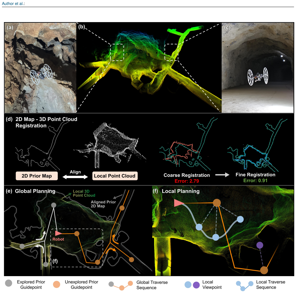
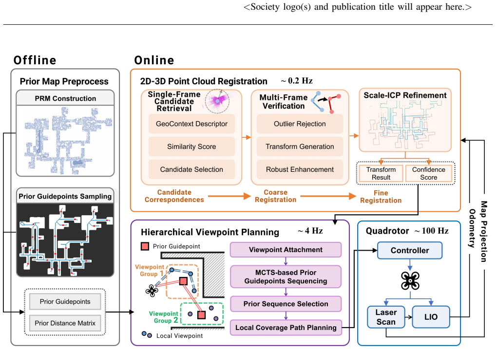
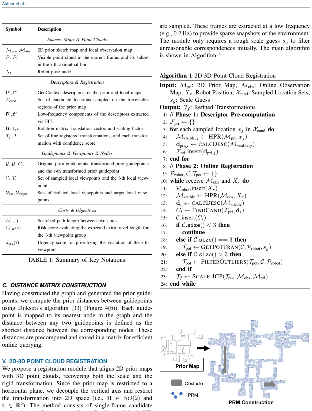
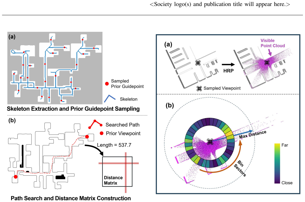
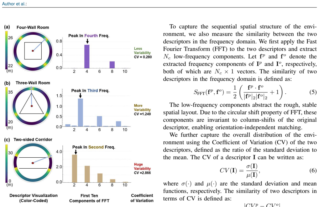
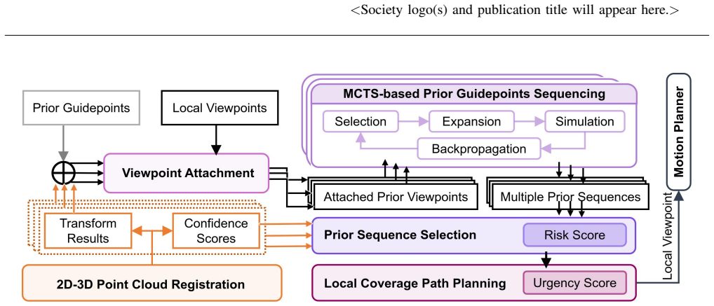
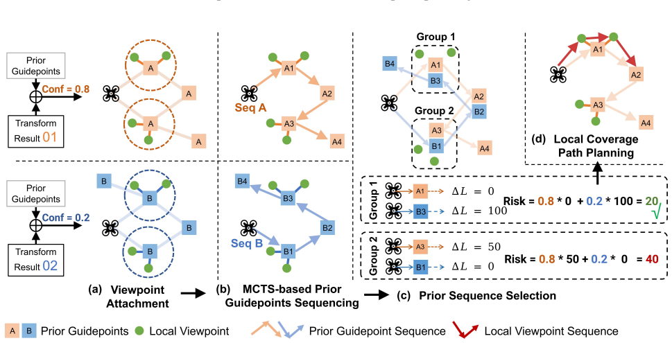
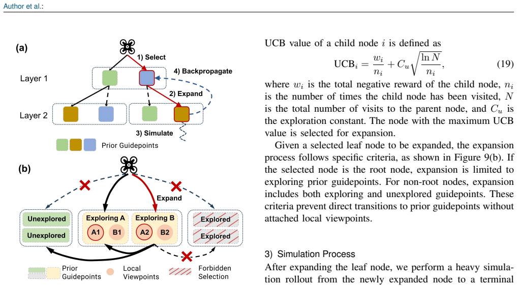
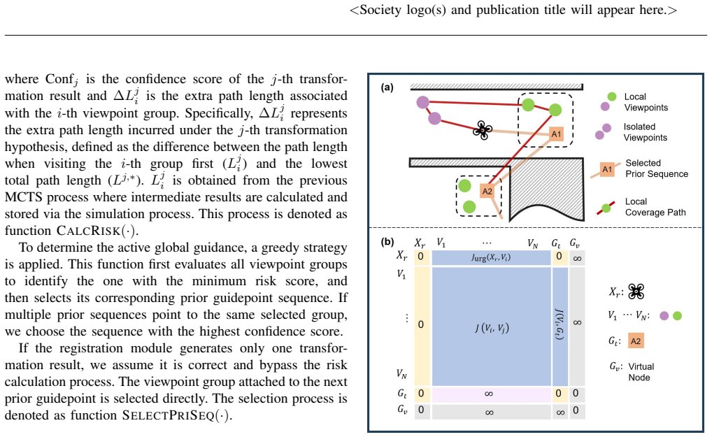
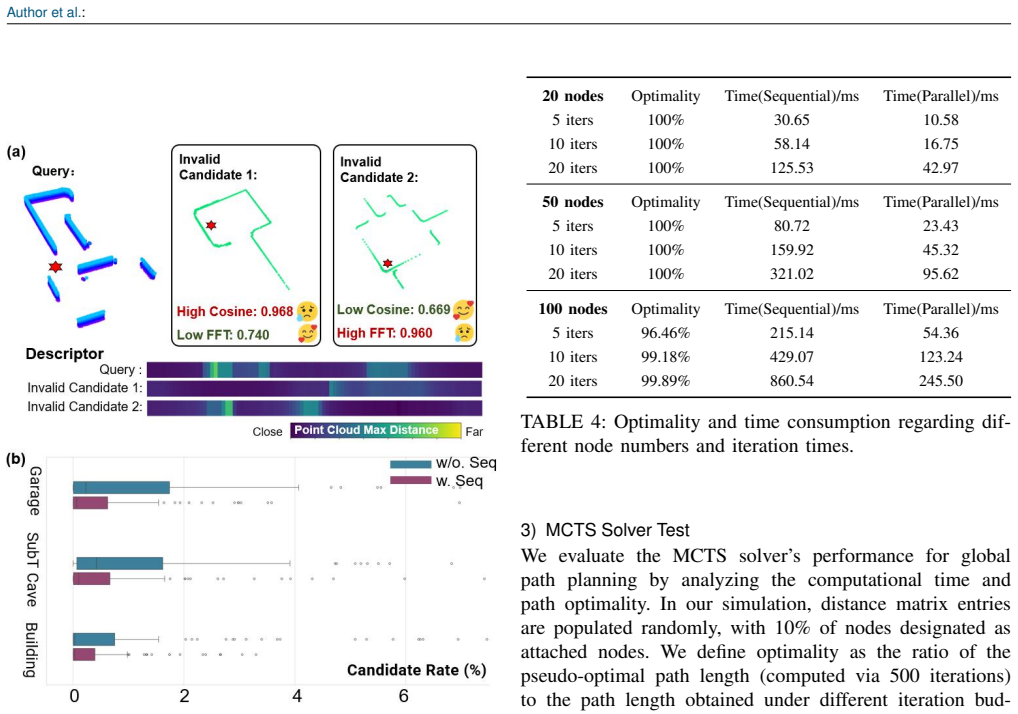
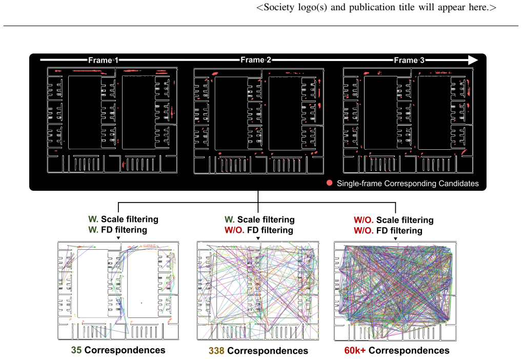
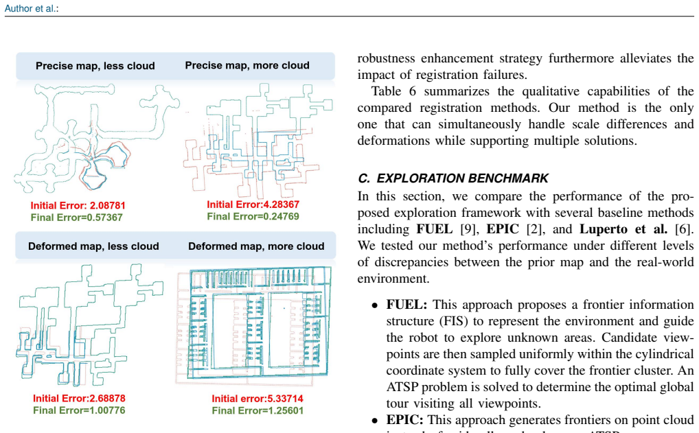
The framework registers LiDAR observations to 2D prior maps through a GeoContext descriptor for single-frame retrieval, multi-frame verification with outlier rejection for coarse transformation, and Scale-ICP for refinement, then applies hierarchical viewpoint planning that attaches local viewpoints to prior guidepoints, solves traversal order via Monte Carlo Tree Search under each hypothesis, selects the sequence by confidence-weighted risk, and solves a fixed-endpoint traveling salesman problem for local coverage.
Load-bearing premise
The registration pipeline can still produce usable alignment hypotheses when prior maps contain discrepancies, incompleteness, and geometric ambiguities.
Editorial extensions
If this is right
- Exploration efficiency improves by up to 34.2 percent over state-of-the-art methods without priors.
- Total flight distance drops by up to 37.9 percent while maintaining coverage.
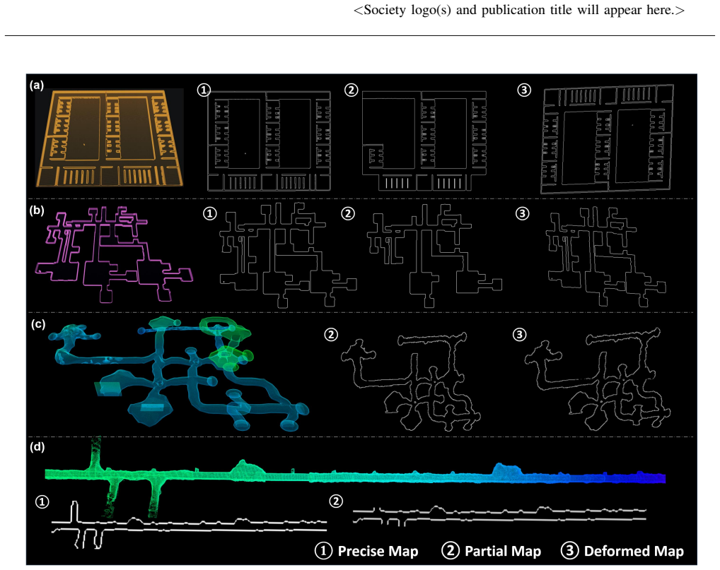
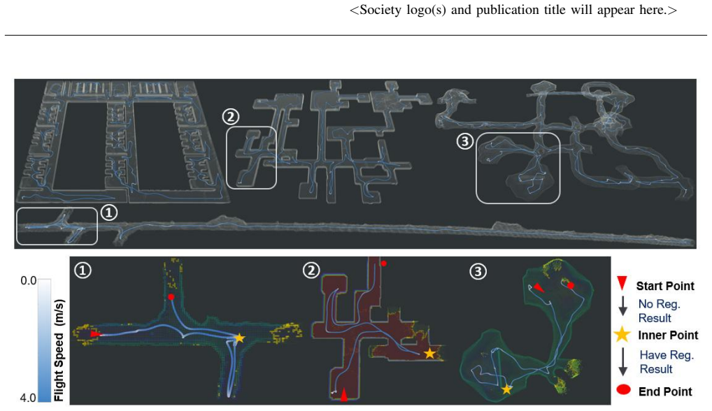
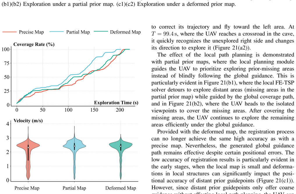
- The system continues to function when prior maps are incomplete or geometrically deformed.
- Multiple registration hypotheses allow the planner to manage cases with geometric ambiguity.
Reading between the lines
- The same registration-plus-risk-selection pattern could be applied to ground robots that carry 2D sketches of warehouses or outdoor sites.
- Adding semantic labels to the prior maps would let the risk selector further bias paths toward high-value regions.
- Online re-registration during flight could extend the method to environments that change after the initial map was drawn.
Editorial analysis
A structured set of objections, weighed in public.
Referee Report
Summary. The paper proposes a framework for accelerating LiDAR-based UAV exploration in large-scale environments by leveraging sparse, unaligned, and discrepant 2D prior maps. It introduces a 2D-3D registration pipeline (GeoContext descriptor for candidate retrieval, multi-frame verification with outlier rejection, and Scale-ICP refinement) that outputs multiple alignment hypotheses, followed by a hierarchical viewpoint planner that attaches local viewpoints to prior guidepoints, uses MCTS to sequence traversals under each hypothesis, applies a risk-aware selector with confidence-weighted travel risk, and solves a fixed-endpoint TSP for local coverage paths. Benchmark results claim up to 34.2% improvement in exploration efficiency and 37.9% reduction in flight distance versus state-of-the-art methods, with additional simulations and field experiments showing robustness to map incompleteness and deformations.
Significance. If the registration pipeline reliably produces usable hypotheses under realistic map imperfections, the work could meaningfully advance UAV exploration by turning readily available but flawed priors into global guidance, reducing detours in topologically complex spaces. The multi-hypothesis MCTS plus risk-aware selection mechanism is a constructive approach to localization uncertainty. The inclusion of both simulation benchmarks and field experiments is a positive feature; however, the absence of quantitative registration metrics (success rates, RMSE, failure modes) on the exact deformation regimes used for the planning benchmarks prevents full attribution of the headline gains to the proposed components.
major comments (2)
- [Registration pipeline] Registration pipeline (described in the methods following the abstract): the central efficiency claims (34.2% exploration improvement, 37.9% distance reduction) rest on the assumption that the GeoContext + multi-frame verification + Scale-ICP pipeline produces usable alignment hypotheses even under the map incompleteness, scale errors, and deformations tested in the later benchmarks. No quantitative registration metrics—success rate, RMSE, or failure-mode breakdown—are supplied for those specific regimes, so it is impossible to confirm that the hierarchical planner is actually exercised rather than falling back to unguided search.
- [Results / benchmark evaluations] Results section (benchmark evaluations): the reported gains are presented as direct comparisons to SOTA methods, yet the manuscript supplies neither error bars, statistical significance tests, nor ablation isolating the contribution of the registration hypotheses versus the risk-aware selector. This makes it difficult to assess whether the improvements are robust or sensitive to post-hoc parameter choices in the MCTS or TSP stages.
minor comments (2)
- [Abstract] The abstract states performance numbers without accompanying equations, dataset sizes, or parameter counts; moving a concise summary of the registration objective or risk metric into the abstract would improve readability.
- [Hierarchical planning] Notation for the confidence-weighted travel risk and the fixed-endpoint TSP formulation is introduced without an explicit equation reference or pseudocode block, complicating direct implementation.
Simulated Author's Rebuttal
We thank the referee for the constructive feedback. The comments correctly identify gaps in quantitative support for the registration pipeline and in the statistical robustness of the results. We will revise the manuscript to address both points.
read point-by-point responses
-
Referee: [Registration pipeline] Registration pipeline (described in the methods following the abstract): the central efficiency claims (34.2% exploration improvement, 37.9% distance reduction) rest on the assumption that the GeoContext + multi-frame verification + Scale-ICP pipeline produces usable alignment hypotheses even under the map incompleteness, scale errors, and deformations tested in the later benchmarks. No quantitative registration metrics—success rate, RMSE, or failure-mode breakdown—are supplied for those specific regimes, so it is impossible to confirm that the hierarchical planner is actually exercised rather than falling back to unguided search.
Authors: We agree that the absence of quantitative registration metrics for the exact benchmark regimes is a limitation. The current manuscript relies on the downstream exploration gains to imply successful registration but does not directly report success rates, RMSE, or failure modes under the tested incompleteness and deformation conditions. In the revised version we will add a new table and accompanying text providing these metrics for the registration pipeline on the same map conditions used in the planning benchmarks, allowing direct verification that the hierarchical planner operates on valid hypotheses rather than defaulting to unguided search. revision: yes
-
Referee: [Results / benchmark evaluations] Results section (benchmark evaluations): the reported gains are presented as direct comparisons to SOTA methods, yet the manuscript supplies neither error bars, statistical significance tests, nor ablation isolating the contribution of the registration hypotheses versus the risk-aware selector. This makes it difficult to assess whether the improvements are robust or sensitive to post-hoc parameter choices in the MCTS or TSP stages.
Authors: We acknowledge that the results section lacks error bars, statistical significance tests, and component ablations. While the reported gains are consistent across the described simulation and field experiments, the manuscript does not quantify variability or isolate the registration hypotheses from the risk-aware selector. In revision we will add error bars to all quantitative plots, include statistical significance tests (e.g., paired t-tests) on the efficiency and distance metrics, and provide an ablation study that compares the full system against variants without multi-hypothesis registration and without the risk-aware selector. These additions will clarify robustness and the source of the observed improvements. revision: yes
Circularity Check
No circularity in derivation chain; claims rest on empirical benchmarks
full rationale
The paper describes a 2D-3D registration pipeline (GeoContext + multi-frame verification + Scale-ICP) and a hierarchical MCTS-based planner with risk-aware selection, but supplies no equations, fitted parameters, or first-principles derivations. The headline efficiency gains (34.2 % / 37.9 %) are presented strictly as outcomes of benchmark comparisons against external baselines, not as quantities predicted or derived from the method itself. No self-citations, uniqueness theorems, or ansatzes are invoked in the provided text to close any loop. The derivation chain is therefore self-contained against external benchmarks and receives the default non-circularity finding.
Assumptions & free parameters
Cite this review
Pith. "Pith review of Explore From Sketch: Accelerating UAV Exploration in Large-scale Environments with Prior Maps." pith.science (2026). https://pith.science/paper/KEBNYU62
@misc{pith2026260611708,
  author       = {Pith},
  title        = {Pith review of: Explore From Sketch: Accelerating UAV Exploration in Large-scale Environments with Prior Maps},
  year         = {2026},
  howpublished = {\url{https://pith.science/paper/KEBNYU62}},
  note         = {Machine review of arXiv:2606.11708}
}
read the original abstract
Autonomous exploration with UAVs in large-scale, topologically complex environments often suffers from low efficiency due to suboptimal scheduling and detours. Prior maps (e.g., construction drawings), although usually imprecise and flawed, are readily available in many scenarios and have the potential to provide global structural guidance. This paper presents a novel exploration framework that leverages sparse, unaligned, and even discrepant 2D prior maps for LiDAR-based UAV exploration. First, a robust 2D-3D point cloud registration pipeline is proposed to align LiDAR observations with prior maps. The registration pipeline combines a GeoContext descriptor for single-frame candidate retrieval, a multi-frame verification mechanism for coarse transformation estimation with outlier rejection, and a Scale-ICP algorithm for refinement. The registration module can handle map discrepancies and provide multiple hypotheses when geometric ambiguities arise. To effectively utilize the registration results for exploration planning, we further develop a hierarchical viewpoint planning strategy under localization uncertainties. The hierarchical strategy first spatially attaches local viewpoints to prior guidepoints and adopts a Monte Carlo Tree Search solver to determine their traversal sequence under each registration hypothesis. To mitigate registration uncertainty, a risk-aware selector evaluates prior sequences using confidence-weighted travel risk, and a fixed-endpoint traveling salesman problem is formulated to generate an efficient local coverage path under the selected prior guidance. Benchmark evaluations reveal up to 34.2% improvement in exploration efficiency and 37.9% reduction in flight distance compared to state-of-the-art methods, while extensive simulations and field experiments further demonstrate robustness to prior map incompleteness and deformations.
Figures
Figures from the paper (18 more)
Reference graph
Works this paper leans on
-
[1]
Falcon: Fast autonomous aerial exploration using coverage path guidance,
Y . Zhang, X. Chen, C. Feng, B. Zhou, and S. Shen, “Falcon: Fast autonomous aerial exploration using coverage path guidance,”IEEE Transactions on Robotics, 2024
2024
-
[2]
Epic: A lightweight lidar-based uav exploration framework for large-scale scenarios,
S. Geng, Z. Ning, F. Zhang, and B. Zhou, “Epic: A lightweight lidar-based uav exploration framework for large-scale scenarios,”IEEE Robotics and Automation Letters, 2025
2025
-
[3]
Receding horizon
A. Bircher, M. Kamel, K. Alexis, H. Oleynikova, and R. Siegwart, “Receding horizon” next-best-view” planner for 3d exploration,” in 2016 IEEE international conference on robotics and automation (ICRA). IEEE, 2016, pp. 1462–1468
2016
-
[4]
Fc-planner: A skeleton-guided planning framework for fast aerial coverage of complex 3d scenes,
C. Feng, H. Li, M. Zhang, X. Chen, B. Zhou, and S. Shen, “Fc-planner: A skeleton-guided planning framework for fast aerial coverage of complex 3d scenes,” in2024 IEEE International Conference on Robotics and Automation (ICRA). IEEE, 2024, pp. 8686–8692
2024
-
[5]
Graph-based slam-aware exploration with prior topo-metric information,
R. Bai, H. Guo, W.-Y . Yau, and L. Xie, “Graph-based slam-aware exploration with prior topo-metric information,”IEEE Robotics and Automation Letters, vol. 9, no. 9, pp. 7597–7604, 2024
2024
-
[6]
Robot exploration of indoor environments using incomplete and inaccurate prior knowledge,
M. Luperto, M. Antonazzi, F. Amigoni, and N. A. Borghese, “Robot exploration of indoor environments using incomplete and inaccurate prior knowledge,”Robotics and Autonomous Systems, vol. 133, p. 103622, 2020
2020
-
[7]
A frontier-based approach for autonomous exploration,
B. Yamauchi, “A frontier-based approach for autonomous exploration,” inProceedings 1997 IEEE International Symposium on Computational Intelligence in Robotics and Automation CIRA’97. ’Towards New Com- putational Principles for Robotics and Automation’. IEEE, 1997, pp. 146–151
1997
-
[8]
Tdle: 2-d lidar exploration with hierarchical planning using regional division,
X. Zhao, C. Yu, E. Xu, and Y . Liu, “Tdle: 2-d lidar exploration with hierarchical planning using regional division,” in2023 IEEE 19th International Conference on Automation Science and Engineering (CASE). IEEE, 2023, pp. 1–6
2023
Show all 49 references
-
[9]
Fuel: Fast uav exploration using incremental frontier structure and hierarchical planning,
B. Zhou, Y . Zhang, X. Chen, and S. Shen, “Fuel: Fast uav exploration using incremental frontier structure and hierarchical planning,”IEEE Robotics and Automation Letters, vol. 6, no. 2, pp. 779–786, 2021
2021
-
[10]
Decen- tralised multi-robot exploration using monte carlo tree search,
S. Bone, L. Bartolomei, F. Kennel-Maushart, and M. Chli, “Decen- tralised multi-robot exploration using monte carlo tree search,” in2023 IEEE/RSJ International Conference on Intelligent Robots and Systems (IROS). IEEE, 2023, pp. 7354–7361
2023
-
[11]
Autonomous exploration with terrestrial-aerial bimodal vehicles,
Y . Gao, R. Zhang, T. Lai, Y . Cao, C. Xu, and F. Gao, “Autonomous exploration with terrestrial-aerial bimodal vehicles,”IEEE Robotics and Automation Letters, vol. 10, no. 10, pp. 9987–9994, 2025
2025
-
[12]
Graph-based subterranean exploration path planning using aerial and legged robots,
T. Dang, M. Tranzatto, S. Khattak, F. Mascarich, K. Alexis, and M. Hutter, “Graph-based subterranean exploration path planning using aerial and legged robots,”Journal of Field Robotics, vol. 37, no. 8, pp. 1363–1388, 2020
2020
-
[13]
A multi-resolution frontier-based planner for autonomous 3d explo- ration,
A. Batinovic, T. Petrovic, A. Ivanovic, F. Petric, and S. Bogdan, “A multi-resolution frontier-based planner for autonomous 3d explo- ration,”IEEE Robotics and Automation Letters, vol. 6, no. 3, pp. 4528– 4535, 2021
2021
-
[14]
Graph-based topological exploration planning in large-scale 3d environments,
F. Yang, D.-H. Lee, J. Keller, and S. Scherer, “Graph-based topological exploration planning in large-scale 3d environments,” in2021 IEEE international conference on robotics and automation (ICRA). IEEE, 2021, pp. 12 730–12 736
2021
-
[15]
Meeting-merging-mission: A multi-robot coordi- nate framework for large-scale communication-limited exploration,
Y . Gao, Y . Wang, X. Zhong, T. Yang, M. Wang, Z. Xu, Y . Wang, Y . Lin, C. Xu, and F. Gao, “Meeting-merging-mission: A multi-robot coordi- nate framework for large-scale communication-limited exploration,” in2022 IEEE/RSJ International Conference on Intelligent Robots and Sys...
2022
-
[16]
Autonomous quadrotor 3d mapping and exploration using exact occupancy probabilities,
E. Kaufman, K. Takami, Z. Ai, and T. Lee, “Autonomous quadrotor 3d mapping and exploration using exact occupancy probabilities,” in 2018 Second IEEE International Conference on Robotic Computing (IRC). IEEE, 2018, pp. 49–55
2018
-
[17]
Motion primitives-based path planning for fast and agile exploration using aerial robots,
M. Dharmadhikari, T. Dang, L. Solanka, J. Loje, H. Nguyen, N. Khedekar, and K. Alexis, “Motion primitives-based path planning for fast and agile exploration using aerial robots,” in2020 IEEE 24 VOLUME , <Society logo(s) and publication title will appear here.> International Co...
2020
-
[18]
Tare: A hierarchical framework for efficiently exploring complex 3d environments
C. Cao, H. Zhu, H. Choset, and J. Zhang, “Tare: A hierarchical framework for efficiently exploring complex 3d environments.” in Robotics: Science and Systems, vol. 5, 2021, p. 2
2021
-
[19]
Outdoor visual localization with a hand- drawn line drawing map using fastslam with pso-based mapping,
K. Matsuo and J. Miura, “Outdoor visual localization with a hand- drawn line drawing map using fastslam with pso-based mapping,” in 2012 IEEE/RSJ International Conference on Intelligent Robots and Systems. IEEE, 2012, pp. 202–207
2012
-
[20]
Robot nav- igation in hand-drawn sketched maps,
F. Boniardi, B. Behzadian, W. Burgard, and G. D. Tipaldi, “Robot nav- igation in hand-drawn sketched maps,” in2015 European conference on mobile robots (ECMR). IEEE, 2015, pp. 1–6
2015
-
[21]
Indoor robot localization in hand- drawn maps by using convolutional neural networks and monte carlo method,
F. Foroughi, J. Wang, and Z. Chen, “Indoor robot localization in hand- drawn maps by using convolutional neural networks and monte carlo method,” inProceedings of the 2019 4th International Conference on Automation, Control and Robotics Engineering, 2019, pp. 1–7
2019
-
[22]
Robot navigation in unseen envi- ronments using coarse maps,
C. Xu, C. Amato, and L. L. Wong, “Robot navigation in unseen envi- ronments using coarse maps,” in2024 IEEE International Conference on Robotics and Automation (ICRA). IEEE, 2024, pp. 2932–2938
2024
-
[23]
Localizing against drawn maps via spline-based registration,
K. Chen, M. V ´azquez, and S. Savarese, “Localizing against drawn maps via spline-based registration,” in2020 IEEE/RSJ International Conference on Intelligent Robots and Systems (IROS). IEEE, 2020, pp. 8521–8526
2020
-
[24]
A robust qualitative planner for mobile robot navigation using human-provided maps,
D. C. Shah and M. E. Campbell, “A robust qualitative planner for mobile robot navigation using human-provided maps,” in2011 IEEE International Conference on Robotics and Automation. IEEE, 2011, pp. 2580–2585
2011
-
[25]
A qualitative path planner for robot navigation using human- provided maps,
——, “A qualitative path planner for robot navigation using human- provided maps,”The International Journal of Robotics Research, vol. 32, no. 13, pp. 1517–1535, 2013
2013
-
[26]
Speak the same language: Global lidar registration on bim using pose hough transform,
Z. Qiao, H. Huang, C. Liu, Z. Yu, S. Shen, F. Zhang, and H. Yin, “Speak the same language: Global lidar registration on bim using pose hough transform,”IEEE Transactions on Automation Science and Engineering, 2025
2025
-
[27]
Su- perglue: Learning feature matching with graph neural networks,
P.-E. Sarlin, D. DeTone, T. Malisiewicz, and A. Rabinovich, “Su- perglue: Learning feature matching with graph neural networks,” in Proceedings of the IEEE/CVF conference on computer vision and pattern recognition, 2020, pp. 4938–4947
2020
-
[28]
Xoftr: Cross-modal feature matching transformer,
¨O. Tuzcuo ˘glu, A. K ¨oksal, B. Sofu, S. Kalkan, and A. A. Alatan, “Xoftr: Cross-modal feature matching transformer,” inProceedings of the IEEE/CVF conference on computer vision and pattern recognition, 2024, pp. 4275–4286
2024
-
[29]
Shape-former: Bridging cnn and transformer via shapeconv for multimodal image matching,
J. Chen, X. Chen, S. Chen, Y . Liu, Y . Rao, Y . Yang, H. Wang, and D. Wu, “Shape-former: Bridging cnn and transformer via shapeconv for multimodal image matching,”Information Fusion, vol. 91, pp. 445– 457, 2023
2023
-
[30]
Analysis of probabilistic roadmaps for path planning,
L. E. Kavraki, M. N. Kolountzakis, and J.-C. Latombe, “Analysis of probabilistic roadmaps for path planning,”IEEE Transactions on Robotics and automation, vol. 14, no. 1, pp. 166–171, 1998
1998
-
[31]
scikit-image: image processing in python,
S. Van der Walt, J. L. Sch ¨onberger, J. Nunez-Iglesias, F. Boulogne, J. D. Warner, N. Yager, E. Gouillart, and T. Yu, “scikit-image: image processing in python,”PeerJ, vol. 2, p. e453, 2014
2014
-
[32]
A fast parallel algorithm for thinning digital patterns,
T. Y . Zhang and C. Y . Suen, “A fast parallel algorithm for thinning digital patterns,”Communications of the ACM, vol. 27, no. 3, pp. 236– 239, 1984
1984
-
[33]
A method for the shortest path search by extended dijkstra algorithm,
M. Noto and H. Sato, “A method for the shortest path search by extended dijkstra algorithm,” inSmc 2000 conference proceedings. 2000 ieee international conference on systems, man and cybernetics. ’cybernetics evolving to systems, humans, organizations, and their complex intera...
2000
-
[34]
Scan context: Egocentric spatial descriptor for place recognition within 3d point cloud map,
G. Kim and A. Kim, “Scan context: Egocentric spatial descriptor for place recognition within 3d point cloud map,” in2018 IEEE/RSJ International Conference on Intelligent Robots and Systems (IROS). IEEE, 2018, pp. 4802–4809
2018
-
[35]
Generating large convex polytopes directly on point clouds,
X. Zhong, Y . Wu, D. Wang, Q. Wang, C. Xu, and F. Gao, “Generating large convex polytopes directly on point clouds,”arXiv preprint arXiv:2010.08744, 2020
2010
-
[36]
dbscan: Fast density- based clustering with r,
M. Hahsler, M. Piekenbrock, and D. Doran, “dbscan: Fast density- based clustering with r,”Journal of Statistical Software, vol. 91, pp. 1–30, 2019
2019
-
[37]
A scale stretch method based on icp for 3d data registration,
S. Ying, J. Peng, S. Du, and H. Qiao, “A scale stretch method based on icp for 3d data registration,”IEEE Transactions on automation science and engineering, vol. 6, no. 3, pp. 559–565, 2009
2009
-
[38]
A survey of monte carlo tree search methods,
C. B. Browne, E. Powley, D. Whitehouse, S. M. Lucas, P. I. Cowling, P. Rohlfshagen, S. Tavener, D. Perez, S. Samothrakis, and S. Colton, “A survey of monte carlo tree search methods,”IEEE Transactions on Computational Intelligence and AI in games, vol. 4, no. 1, pp. 1–43, 2012
2012
-
[39]
General k-opt submoves for the lin–kernighan tsp heuristic,
K. Helsgaun, “General k-opt submoves for the lin–kernighan tsp heuristic,”Mathematical Programming Computation, vol. 1, no. 2, pp. 119–163, 2009
2009
-
[40]
Geometric a- star algorithm: An improved a-star algorithm for agv path planning in a port environment,
G. Tang, C. Tang, C. Claramunt, X. Hu, and P. Zhou, “Geometric a- star algorithm: An improved a-star algorithm for agv path planning in a port environment,”IEEE access, vol. 9, pp. 59 196–59 210, 2021
2021
-
[41]
Geometrically constrained tra- jectory optimization for multicopters,
Z. Wang, X. Zhou, C. Xu, and F. Gao, “Geometrically constrained tra- jectory optimization for multicopters,”IEEE Transactions on Robotics, vol. 38, no. 5, pp. 3259–3278, 2022
2022
-
[42]
Fast iterative region inflation for computing large 2-d/3-d convex regions of obstacle-free space,
Q. Wang, Z. Wang, M. Wang, J. Ji, Z. Han, T. Wu, R. Jin, Y . Gao, C. Xu, and F. Gao, “Fast iterative region inflation for computing large 2-d/3-d convex regions of obstacle-free space,”IEEE Transactions on Robotics, 2025
2025
-
[43]
A subterranean virtual cave world for gazebo based on the darpa subt challenge,
A. Koval, C. Kanellakis, E. Vidmark, J. Haluska, and G. Nikolakopou- los, “A subterranean virtual cave world for gazebo based on the darpa subt challenge,”arXiv preprint arXiv:2004.08452, 2020
2004
-
[44]
Superpoint: Self- supervised interest point detection and description,
D. DeTone, T. Malisiewicz, and A. Rabinovich, “Superpoint: Self- supervised interest point detection and description,” inProceedings of the IEEE conference on computer vision and pattern recognition workshops, 2018, pp. 224–236
2018
-
[45]
Locally optimized ransac,
O. Chum, J. Matas, and J. Kittler, “Locally optimized ransac,” inJoint pattern recognition symposium. Springer, 2003, pp. 236–243
2003
-
[46]
Marsim: A light-weight point-realistic simulator for lidar- based uavs,
F. Kong, X. Liu, B. Tang, J. Lin, Y . Ren, Y . Cai, F. Zhu, N. Chen, and F. Zhang, “Marsim: A light-weight point-realistic simulator for lidar- based uavs,”IEEE Robotics and Automation Letters, vol. 8, no. 5, pp. 2954–2961, 2023
2023
-
[47]
Fast-lio2: Fast direct lidar- inertial odometry,
W. Xu, Y . Cai, D. He, J. Lin, and F. Zhang, “Fast-lio2: Fast direct lidar- inertial odometry,”IEEE Transactions on Robotics, vol. 38, no. 4, pp. 2053–2073, 2022
-
[48]
Nonlinear control of vtol uavs incorporating flapping dynamics,
S. Omari, M.-D. Hua, G. Ducard, and T. Hamel, “Nonlinear control of vtol uavs incorporating flapping dynamics,” in2013 IEEE/RSJ international conference on intelligent robots and systems. IEEE, 2013, pp. 2419–2425
2013
-
[49]
Robust trajectory planning for spatial- temporal multi-drone coordination in large scenes,
Z. Wang, C. Xu, and F. Gao, “Robust trajectory planning for spatial- temporal multi-drone coordination in large scenes,” in2022 IEEE/RSJ International Conference on Intelligent Robots and Systems (IROS). IEEE, 2022, pp. 12 182–12 188. VOLUME , 25
2022
Reviewed June 27, 2026 · model on record in the stance chip above.
Discussion (0). Sign in to comment.