REVIEW 2 major objections 36 references
LOGOS: LiDAR-Only Gaussian Elevation Splatting for Unified Tiny Obstacle Segmentation
T0 review · 2 major / 0 minor · reviewed 2026-06-26 · grok-4.3
Pith's one-line read LiDAR-only Gaussian splatting segments tiny obstacles by modeling roads as 2D Gaussian mixtures and computing signed elevations without backpropagation or RGB data.
desk verdict LOGOS adds a backprop-free LiDAR Gaussian splatting pipeline for tiny obstacles, but the smoothness pruning step looks like the part that needs the most checking. read the letter →
The pith
A machine-rendered reading of the paper's core claim, the machinery that carries it, and where it could break.
The reading
What carries the argument
The normal-aware elevation splatting function that computes pointwise signed distances from a mixture of 2D Gaussian primitives representing the road surface after freespace-aware initialization and smoothness-constrained pruning of non-road elements.
What would settle it
A collection of LiDAR frames from sloped off-road terrain containing both natural undulations and tiny obstacles, acquired under heavy point degradation, where the pruned Gaussian mixture produces signed distances that systematically misclassify undulations as obstacles or miss actual obstacles.
Extended reading notes
Core claim
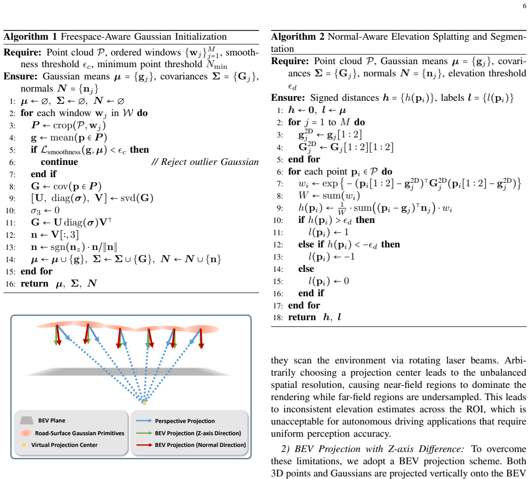
LOGOS models the road surface as a continuous mixture of 2D Gaussian primitives and distinguishes tiny obstacles via high-precision elevation estimation. It is a backpropagation-free LiDAR-only approach that directly estimates Gaussian parameters via a freespace-aware initialization by incrementally pruning non-road primitives using smoothness constraints. Subsequently, pointwise signed distances are computed via a novel normal-aware elevation splatting function, ensuring robustness to both flat and sloped terrains.
Load-bearing premise
The road surface can be modeled as a continuous mixture of 2D Gaussian primitives, with incremental pruning of non-road primitives using smoothness constraints correctly distinguishing road from obstacles even under terrain variations and point cloud degradation.
Editorial extensions
If this is right
- LOGOS achieves higher segmentation accuracy than existing methods on both urban mobility and mining haulage off-road scenes.
- Performance remains strong in degraded point cloud regions where prior approaches deteriorate.
- The system maintains real-time efficiency across heterogeneous datasets with varying point densities and obstacle types.
- A single unified pipeline works for different LiDAR sensors without requiring RGB input or iterative training.
Reading between the lines
- The elevation estimates could serve as input priors for sensor fusion pipelines that combine LiDAR with cameras or radar in low-visibility settings.
- Periodic re-initialization of the Gaussian primitives from new scans might support adaptation to slowly changing surfaces such as accumulating gravel.
- The pruning mechanism could be tested on airborne or handheld LiDAR collections to check whether the same smoothness constraints hold outside ground-vehicle geometries.
Signed reviews
Editorial analysis
A structured set of objections, weighed in public.
Referee Report
Summary. The paper proposes LOGOS, a LiDAR-only system for unified tiny obstacle segmentation that models the road surface as a continuous mixture of 2D Gaussian primitives. It uses freespace-aware initialization followed by incremental pruning of non-road primitives via smoothness constraints, then applies normal-aware elevation splatting to compute pointwise signed distances for obstacle distinction. The method is presented as backpropagation-free and is evaluated on heterogeneous point cloud data from urban and off-road mining environments with varying densities, terrain roughness, and obstacle types, claiming significant outperformance over SOTA methods especially in degraded regions while maintaining real-time efficiency.
Significance. If the pruning and splatting components prove reliable, the work could meaningfully advance LiDAR-based perception for robotics by addressing tiny obstacles (curbs, gravel, potholes) and data degradation in both structured and unstructured terrains without relying on RGB or iterative optimization. The heterogeneous benchmark spanning different sensors and environments is a positive aspect for practical relevance.
major comments (2)
- [Abstract] Abstract: The central performance claim (significant outperformance in degraded point cloud regions and off-road scenarios) is presented without any quantitative metrics, error bars, dataset sizes, or ablation results. This makes it impossible to assess whether the smoothness-constrained pruning reliably preserves road primitives while removing obstacles under the claimed variations in density and terrain.
- [Abstract] Abstract (pruning step): The incremental pruning of non-road primitives using smoothness constraints is load-bearing for the robustness claims, yet no characterization is given of pruning error rates, failure cases on locally violated smoothness (e.g., gravel, potholes, slopes), or controlled degradation tests. Without this, the distinction between road undulations and tiny obstacles cannot be verified.
Simulated Author's Rebuttal
We thank the referee for the constructive feedback on the abstract. We address each major comment below and will incorporate revisions to strengthen the presentation of our claims.
read point-by-point responses
-
Referee: [Abstract] Abstract: The central performance claim (significant outperformance in degraded point cloud regions and off-road scenarios) is presented without any quantitative metrics, error bars, dataset sizes, or ablation results. This makes it impossible to assess whether the smoothness-constrained pruning reliably preserves road primitives while removing obstacles under the claimed variations in density and terrain.
Authors: We agree that the abstract would benefit from including key quantitative results. In the revised version, we will add specific metrics such as mIoU improvements on degraded regions and off-road scenarios, along with dataset sizes and references to the ablation studies and error bars presented in the experiments section. This will better support evaluation of the pruning reliability under varying densities and terrains. revision: yes
-
Referee: [Abstract] Abstract (pruning step): The incremental pruning of non-road primitives using smoothness constraints is load-bearing for the robustness claims, yet no characterization is given of pruning error rates, failure cases on locally violated smoothness (e.g., gravel, potholes, slopes), or controlled degradation tests. Without this, the distinction between road undulations and tiny obstacles cannot be verified.
Authors: We acknowledge that additional characterization of the pruning step would strengthen the robustness claims. We will add a new analysis subsection (or appendix) detailing pruning error rates, failure cases on terrains with locally violated smoothness such as gravel, potholes, and slopes, and results from controlled degradation tests. This will help verify the distinction between road undulations and tiny obstacles. revision: yes
Circularity Check
No circularity: derivation is self-contained algorithmic construction
full rationale
The paper defines an explicit pipeline (freespace-aware seeding of 2D Gaussians, incremental smoothness-constrained pruning of non-road primitives, normal-aware elevation splatting) whose steps are stated as direct computations from input point clouds. No equations reduce a claimed prediction to a fitted parameter by construction, no self-citations supply load-bearing uniqueness results, and no ansatz is smuggled via prior work. Performance claims rest on external heterogeneous benchmarks rather than internal consistency alone.
Assumptions & free parameters
Cite this review
Pith. "Pith review of LOGOS: LiDAR-Only Gaussian Elevation Splatting for Unified Tiny Obstacle Segmentation." pith.science (2026). https://pith.science/paper/M4QTWQYS
@misc{pith2026260621527,
  author       = {Pith},
  title        = {Pith review of: LOGOS: LiDAR-Only Gaussian Elevation Splatting for Unified Tiny Obstacle Segmentation},
  year         = {2026},
  howpublished = {\url{https://pith.science/paper/M4QTWQYS}},
  note         = {Machine review of arXiv:2606.21527}
}
read the original abstract
Robust obstacle segmentation is essential for the safety of intelligent robots, where LiDAR-based perception systems play a fundamental role in the robot-environment interaction. While extensive LiDAR-based approaches have demonstrated high performance on common obstacles in urban scenarios, their results on tiny obstacles such as curbs, gravel, and potholes remain unsatisfactory due to the significant similarity between tiny obstacles and inherent road undulations. Moreover, their segmentation accuracy even deteriorates sharply when the LiDAR scans suffer from degradation in challenging off-road scenes. To overcome these bottlenecks, we propose LOGOS, a LiDAR-only unified tiny obstacle segmentation system, which models the road surface as a continuous mixture of 2D Gaussian primitives and distinguishes tiny obstacles via high-presicion elevation estimation. Unlike existing Gaussian splatting methods that rely on iterative RGB training, LOGOS is a backpropagation-free LiDAR-only approach. It directly estimates Gaussian parameters via a freespace-aware initialization by incrementally pruning non-road primitives using smoothness constraints. Subsequently, pointwise signed distances are computed via a novel normal-aware elevation splatting function, ensuring robustness to both flat and sloped terrains. We evaluate LOGOS on a highly heterogeneous benchmark of point cloud frames collected from urban mobility scenarios and mining haulage off-road environments. These data are practically acquired using different LiDAR sensors and exhibit large variations in point density, terrain roughness, and obstacle types. Experiments on the road and off-road scenes demonstrate that LOGOS significantly outperforms other state-of-the-art methods, particularly in degraded point cloud regions and challenging off-road scenarios, while maintaining real-time efficiency.
Figures


Figures from the paper (1 more)

Reference graph
Works this paper leans on
-
[1]
Positive and negative obstacle detection using the hld classifier,
R. D. Morton and E. Olson, “Positive and negative obstacle detection using the hld classifier,” inIEEE/RSJ International Conference on Intelligent Robots and Systems (IROS). IEEE, 2011, pp. 1579–1584
2011
-
[2]
Are we hungry for 3d lidar data for semantic segmentation? a survey of datasets and methods,
B. Gao, Y . Pan, C. Li, S. Geng, and H. Zhao, “Are we hungry for 3d lidar data for semantic segmentation? a survey of datasets and methods,” IEEE Transactions on Intelligent Transportation Systems, vol. 23, no. 7, pp. 6063–6081, 2021
2021
-
[3]
Lidar guided small obstacle segmentation,
A. Singh, A. Kamireddypalli, V . Gandhi, and K. M. Krishna, “Lidar guided small obstacle segmentation,” inIEEE/RSJ International Con- ference on Intelligent Robots and Systems (IROS). IEEE, 2020, pp. 8513–8520
2020
-
[4]
Design of robot vehicle undercarriage with ability to operate in broken terrain,
R. Surovec, A. Gmiterko, M. Vackova, I. Virgala, E. Prada, and T. Pipik, “Design of robot vehicle undercarriage with ability to operate in broken terrain,”Procedia Engineering, vol. 48, pp. 650–655, 2012
2012
-
[5]
Inconseg: Residual-guided fusion with inconsistent multi-modal data for negative and positive road obstacles segmentation,
Z. Feng, Y . Guo, D. Navarro-Alarcon, Y . Lyu, and Y . Sun, “Inconseg: Residual-guided fusion with inconsistent multi-modal data for negative and positive road obstacles segmentation,”IEEE Robotics and Automa- tion Letters, vol. 8, no. 8, pp. 4871–4878, 2023
2023
-
[6]
3d gaussian splatting for real-time radiance field rendering
B. Kerbl, G. Kopanas, T. Leimk ¨uhler, G. Drettakis,et al., “3d gaussian splatting for real-time radiance field rendering.”ACM Trans. Graph., vol. 42, no. 4, pp. 139–1, 2023
2023
-
[7]
2d gaussian splatting for geometrically accurate radiance fields,
B. Huang, Z. Yu, A. Chen, A. Geiger, and S. Gao, “2d gaussian splatting for geometrically accurate radiance fields,” inACM SIGGRAPH 2024 conference papers, 2024, pp. 1–11
2024
-
[8]
Automated segmentation of gravel particles from depth images of gravel-soil mixtures,
H. Rahmani, C. Scanlan, U. Nadeem, M. Bennamoun, and R. Bowles, “Automated segmentation of gravel particles from depth images of gravel-soil mixtures,”Computers & geosciences, vol. 128, pp. 1–10, 2019
2019
Show all 36 references
-
[9]
Computer vision for road imaging and pothole detection: a state-of-the-art review of systems and algorithms,
N. Ma, J. Fan, W. Wang, J. Wu, Y . Jiang, L. Xie, and R. Fan, “Computer vision for road imaging and pothole detection: a state-of-the-art review of systems and algorithms,”Transportation safety and Environment, vol. 4, no. 4, pp. 1–16, 2022
2022
-
[10]
A progressive morphological filter for removing nonground measure- ments from airborne lidar data,
K. Zhang, S.-C. Chen, D. Whitman, M.-L. Shyu, J. Yan, and C. Zhang, “A progressive morphological filter for removing nonground measure- ments from airborne lidar data,”IEEE Transactions on Geoscience and Remote Sensing, vol. 41, no. 4, pp. 872–882, 2003
2003
-
[11]
Rangenet++: Fast and accurate lidar semantic segmentation,
A. Milioto, I. Vizzo, J. Behley, and C. Stachniss, “Rangenet++: Fast and accurate lidar semantic segmentation,” inIEEE/RSJ International Conference on Intelligent Robots and Systems (IROS). IEEE, 2019, pp. 4213–4220
2019
-
[12]
2dpass: 2d priors assisted semantic segmentation on lidar point clouds,
X. Yan, J. Gao, C. Zheng, C. Zheng, R. Zhang, S. Cui, and Z. Li, “2dpass: 2d priors assisted semantic segmentation on lidar point clouds,” inEuropean Conference on Computer Vision. Springer, 2022, pp. 677– 695
2022
-
[13]
Point-to-voxel knowledge distillation for lidar semantic segmentation,
Y . Hou, X. Zhu, Y . Ma, C. C. Loy, and Y . Li, “Point-to-voxel knowledge distillation for lidar semantic segmentation,” inProceedings of the IEEE/CVF Conference on Computer Vision and Pattern Recognition, 2022, pp. 8479–8488
2022
-
[14]
Spherical transformer for lidar- based 3d recognition,
X. Lai, Y . Chen, F. Lu, J. Liu, and J. Jia, “Spherical transformer for lidar- based 3d recognition,” inProceedings of the IEEE/CVF Conference on Computer Vision and Pattern Recognition, 2023, pp. 17 545–17 555
2023
-
[15]
Transrvnet: Lidar semantic segmenta- tion with transformer,
H. Cheng, X. Han, and G. Xiao, “Transrvnet: Lidar semantic segmenta- tion with transformer,”IEEE Transactions on Intelligent Transportation Systems, vol. 24, no. 6, pp. 5895–5907, 2023
2023
-
[16]
Tfnet: Exploiting temporal cues for fast and accurate lidar semantic segmentation,
R. Li, S. Li, X. Chen, T. Ma, J. Gall, and J. Liang, “Tfnet: Exploiting temporal cues for fast and accurate lidar semantic segmentation,” in Proceedings of the IEEE/CVF Conference on Computer Vision and Pattern Recognition, 2024, pp. 4547–4556
2024
-
[17]
Taseg: Temporal aggregation network for lidar semantic segmentation,
X. Wu, Y . Hou, X. Huang, B. Lin, T. He, X. Zhu, Y . Ma, B. Wu, H. Liu, D. Cai,et al., “Taseg: Temporal aggregation network for lidar semantic segmentation,” inProceedings of the IEEE/CVF Conference on Computer Vision and Pattern Recognition, 2024, pp. 15 311–15 320
2024
-
[18]
Road surface distress detection in disparity space,
A. Dhiman, H.-J. Chien, and R. Klette, “Road surface distress detection in disparity space,” inInternational Conference on Image and Vision Computing New Zealand (IVCNZ). IEEE, 2017, pp. 1–6
2017
-
[19]
Overview of the ransac algorithm,
K. G. Derpanis, “Overview of the ransac algorithm,”Image Rochester NY, vol. 4, no. 1, pp. 2–3, 2010
2010
-
[20]
Scale-adaptive pothole detection and tracking from 3-d road point clouds,
R. Wu, J. Fan, L. Guo, L. Qiao, M. U. M. Bhutta, B. Hosking, S. Vityazev, and R. Fan, “Scale-adaptive pothole detection and tracking from 3-d road point clouds,” in2021 IEEE International Conference on Imaging Systems and Techniques (IST). IEEE, 2021, pp. 1–5
2021
-
[21]
Patchwork: Concentric zone-based region-wise ground segmentation with ground likelihood estimation using a 3d lidar sensor,
H. Lim, M. Oh, and H. Myung, “Patchwork: Concentric zone-based region-wise ground segmentation with ground likelihood estimation using a 3d lidar sensor,”IEEE Robotics and Automation Letters, vol. 6, no. 4, pp. 6458–6465, 2021
2021
-
[22]
Patchwork++: Fast and robust ground segmentation solving partial under-segmentation using 3d point cloud,
S. Lee, H. Lim, and H. Myung, “Patchwork++: Fast and robust ground segmentation solving partial under-segmentation using 3d point cloud,” inIEEE/RSJ International Conference on Intelligent Robots and Systems (IROS). IEEE, 2022, pp. 13 276–13 283
2022
-
[23]
Dipg-seg: Fast and accurate double image-based pixel-wise ground segmentation,
H. Wen, S. Liu, Y . Liu, and C. Liu, “Dipg-seg: Fast and accurate double image-based pixel-wise ground segmentation,”IEEE Transactions on Intelligent Transportation Systems, pp. 1–12, 2023
2023
-
[24]
Ta-tos: Terrain- aware tiny obstacle segmentation based on mrf road modeling using 3-d lidar scans,
N. Ming, Y . Qian, C. Feng, C. Wang, and M. Yang, “Ta-tos: Terrain- aware tiny obstacle segmentation based on mrf road modeling using 3-d lidar scans,”IEEE Transactions on Intelligent Transportation Systems, vol. 26, no. 10, pp. 15 985–16 000, 2025
2025
-
[25]
Gndnet: Fast ground plane estimation and point cloud segmentation for au- tonomous vehicles,
A. Paigwar, ¨O. Erkent, D. Sierra-Gonzalez, and C. Laugier, “Gndnet: Fast ground plane estimation and point cloud segmentation for au- tonomous vehicles,” inIEEE/RSJ International Conference on Intelligent Robots and Systems (IROS). IEEE, 2020, pp. 2150–2156
2020
-
[26]
Shape- up: Shaping discrete geometry with projections,
S. Bouaziz, M. Deuss, Y . Schwartzburg, T. Weise, and M. Pauly, “Shape- up: Shaping discrete geometry with projections,” inComputer Graphics Forum (CGF), vol. 31, no. 5. Wiley Online Library, 2012, pp. 1657– 1667
2012
-
[27]
As-rigid-as-possible surface modeling,
O. Sorkine and M. Alexa, “As-rigid-as-possible surface modeling,” in Symposium on Geometry Processing (SGP), vol. 4, 2007, pp. 109–116
2007
-
[28]
Squeezeseg: Convolutional neural nets with recurrent crf for real-time road-object segmentation from 3d lidar point cloud,
B. Wu, A. Wan, X. Yue, and K. Keutzer, “Squeezeseg: Convolutional neural nets with recurrent crf for real-time road-object segmentation from 3d lidar point cloud,” inIEEE International Conference on Robotics and Automation (ICRA). IEEE, 2018, pp. 1887–1893
2018
-
[29]
Semantic graph based place recognition for 3d point clouds,
X. Kong, X. Yang, G. Zhai, X. Zhao, X. Zeng, M. Wang, Y . Liu, W. Li, and F. Wen, “Semantic graph based place recognition for 3d point clouds,” inIEEE/RSJ International Conference on Intelligent Robots and Systems (IROS). IEEE, 2020, pp. 8216–8223
2020
-
[30]
Deepsdf: Learning continuous signed distance functions for shape rep- resentation,
J. J. Park, P. Florence, J. Straub, R. Newcombe, and S. Lovegrove, “Deepsdf: Learning continuous signed distance functions for shape rep- resentation,” inProceedings of the IEEE/CVF Conference on Computer Vision and Pattern Recognition (CVPR), 2019, pp. 165–174
2019
-
[31]
Nerf: Representing scenes as neural radiance fields for view synthesis,
B. Mildenhall, P. P. Srinivasan, M. Tancik, J. T. Barron, R. Ramamoorthi, and R. Ng, “Nerf: Representing scenes as neural radiance fields for view synthesis,”Communications of the ACM, vol. 65, no. 1, pp. 99–106, 2021
2021
-
[32]
Neus2: Fast learning of neural implicit surfaces for multi- view reconstruction,
Y . Wang, Q. Han, M. Habermann, K. Daniilidis, C. Theobalt, and L. Liu, “Neus2: Fast learning of neural implicit surfaces for multi- view reconstruction,” inProceedings of the IEEE/CVF International Conference on Computer Vision (ICCV), 2023, pp. 3295–3306
2023
-
[33]
Instant neural graphics primitives with a multiresolution hash encoding,
T. M ¨uller, A. Evans, C. Schied, and A. Keller, “Instant neural graphics primitives with a multiresolution hash encoding,”ACM Transactions on Graphics, vol. 41, no. 4, pp. 1–15, 2022
2022
-
[34]
Event-3dgs: Event-based 3d recon- struction using 3d gaussian splatting,
H. Han, J. Li, H. Wei, and X. Ji, “Event-3dgs: Event-based 3d recon- struction using 3d gaussian splatting,”Advances in Neural Information Processing Systems (NeurIPS), vol. 37, pp. 128 139–128 159, 2024
2024
-
[35]
Pothole detection based on disparity transformation and road surface modeling,
R. Fan, U. Ozgunalp, B. Hosking, M. Liu, and I. Pitas, “Pothole detection based on disparity transformation and road surface modeling,” IEEE Transactions on Image Processing, vol. 29, pp. 897–908, 2019
2019
-
[36]
The pascal visual object classes challenge: A retrospective,
M. Everingham, S. A. Eslami, L. Van Gool, C. K. Williams, J. Winn, and A. Zisserman, “The pascal visual object classes challenge: A retrospective,”International Journal of Computer Vision, vol. 111, pp. 98–136, 2015
2015
Reviewed June 26, 2026 · model on record in the stance chip above.
Discussion (0). Continue with ORCID to comment.