REVIEW 2 major objections 5 minor 59 references
CityLLM: A framework for natural-language querying of semantic 3D city models
T0 review · 2 major / 5 minor · reviewed 2026-08-02 · deepseek-v4-flash
Pith's one-line read CityLLM turns plain-language questions into accurate queries over 3D city models, with a perfect score on a 54-question test.
desk verdict CityLLM is a clean two-backend LLM-query system for CityJSON, with the cross-database chaining genuinely new and the evaluation too self-contained to trust the headline percentages. read the letter →
The pith
A machine-rendered reading of the paper's core claim, the machinery that carries it, and where it could break.
The reading
What carries the argument
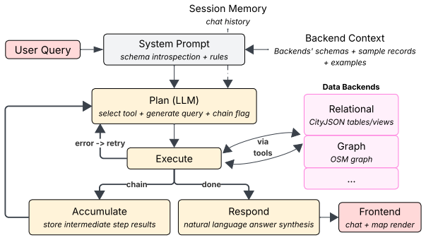
The load-bearing component is the combination of a purpose-built relational schema for the city model (object attributes separated from geometries, with precomputed derived properties and a simplified per-object view) and a graph schema for street networks and amenities, plus the LLM agent's constrained workflow: explicit tool selection, structured query generation, iterative error-fed retries, and cross-database chaining. This machinery does the work of turning natural language into reliable database queries.
What would settle it
Run the same pipeline on a different city's CityJSON dataset with a new set of, say, 100 natural-language questions written by independent users, and measure answer correctness; if accuracy falls well below the reported 85–100% range, or the open-source model no longer leads, the central claim fails.
Extended reading notes
Core claim
The central claim is that strong conversational querying of semantic 3D city models can be achieved through a modular architecture that maps CityJSON geometry and attributes into a compact relational schema, stores street-network and amenity data in a graph database, and lets an LLM agent choose the backend, generate SQL or the graph query language, chain results across backends when needed, and repair failed queries by feeding database errors back into the model. The authors demonstrate this with a 54-query evaluation on a Rotterdam CityJSON dataset, reporting 100% query success across all models, answer correctness of 100%, 94.4%, and 85.2% for three LLMs, and visualization correctness of
Load-bearing premise
The reported accuracy rests on the authors' own manual judgment of 54 self-curated queries against expected answers, so the results are only as representative and unbiased as that question set and those judgments.
Editorial extensions
If this is right
- Non-expert users can interrogate 3D city models conversationally without learning SQL, graph query languages, or GIS software.
- Cross-database questions that combine building data with street networks and amenities can be answered through chained queries.
- Iterative query refinement with database error feedback reliably produces executable queries, even when initial attempts fail.
- Smaller, open-source LLMs can match or exceed larger proprietary models when given structured schema context and clear tool boundaries.
- The architecture is modular, so adding new data backends (e.g., sensor data, regulatory documents) is a natural extension.
Reading between the lines
- The evaluation is small and self-curated; transferring the framework to other cities and larger, user-generated question sets would test whether the reported accuracy generalizes.
- The finding that schema design and prompt constraints may matter more than raw model capability could shift how practitioners build LLM-based data interfaces.
- A testable extension is to apply the same framework to other semantic 3D formats (e.g., CityGML or IFC) and see if the compact-schema approach holds up.
- Reducing the large system prompt via dynamic context retrieval, as the authors note, could make the framework lighter and cheaper without losing accuracy.
Editorial analysis
A structured set of objections, weighed in public.
Referee Report
Summary. This paper presents CityLLM, an LLM-based agent framework for querying semantic 3D city models. CityJSON data are stored in PostgreSQL/PostGIS using a compact relational schema, while OpenStreetMap street networks and amenities are stored in a Neo4j graph database. An LLM agent translates natural-language queries into SQL or Cypher, supports iterative retry on execution errors, and chains across databases when needed; results are returned conversationally and visualized on an interactive map. The authors evaluate the framework on a Rotterdam CityJSON dataset (853 LoD2 buildings) using 54 self-curated queries grouped into spatial, graph, cross-database, and conversational scenarios, with GPT-OSS (120B), Gemini 3.1, and GPT-5.4. Reported results are high: answer correctness 85.2–100%, visualization correctness 92.9–100%, 100% query success, and few retries. The paper includes worked examples of generated SQL/Cypher and documented failure cases.
Significance. If the evaluation were independently reproducible, CityLLM would be a useful and pragmatic contribution to lowering the barrier for non-expert querying of semantic 3D city models. The architecture is clearly described, and Tables 3–5 provide valuable concrete examples of the generated SQL/Cypher and cross-database chaining. The paper's candor in reporting failure cases and in re-evaluating them with model variants is a strength. However, the quantitative claims currently rest on an internal, non-released evaluation protocol: 54 author-curated queries, author-defined expected answers, and author-performed manual scoring, with no inter-annotator agreement, no repeated runs, and no release of the benchmark artifacts. This is a serious reproducibility and validity concern that should be addressed before the headline accuracy figures can be taken as robust evidence for the framework's performance.
major comments (2)
- [§4, Tables 1–2] The headline quantitative claims (answer correctness 85.2–100%, visualization correctness 92.9–100%) are supported only by the §4 protocol: 54 queries curated by the authors, expected answers defined by the authors, and all criteria 'checked manually by the authors' against those expected answers. No query list, expected answers, rubric, transcripts, or code are released; no inter-annotator agreement is reported; and each query was run once. This design leaves substantial room for selection and judgment bias, so the reported percentages are not reproducible. I recommend releasing the full benchmark (queries, expected answers, raw outputs, and generated SQL/Cypher), running each query multiple times, and obtaining independent human annotations with agreement statistics (e.g., Cohen's κ). At minimum, the results should be presented as a pilot study rather than as definitive comparative acc
- [§3.2, §5] The paper attributes the strong results to the framework's components — schema introspection, iterative retry, and cross-database chaining — but provides no ablation or comparison against a direct LLM baseline (e.g., a single-prompt, no-retry, no-schema-context setting). Because 'query success' is defined as successful execution within the retry limit, that metric is saturated by construction and carries little discriminative power; the meaningful metric is answer correctness. Without a baseline, it is unclear whether the orchestration adds value beyond the raw LLM's native ability to generate SQL/Cypher from a prompt. I recommend adding an ablation study that removes each framework component, or at least one no-framework baseline, to substantiate the contribution.
minor comments (5)
- [Table 4] Table 4 is very hard to parse. The caption says '-' denotes a correct response, but the cell alignment in the rendered table is ambiguous: for example, the PostGIS Q1 row appears to show 'Building -[Failed to return distinct types.]' in the GPT-OSS column, which conflicts with GPT-OSS's perfect score in Table 2. Please restructure the table (e.g., separate sub-tables per model, color-coding, or explicit cell rows) so that each failure description is clearly attributable to the correct model.
- [Throughout] Model naming is inconsistent: 'GPT-OSS (120B)' in Table 1 vs 'GPT-OSS' in the text; 'Gemini 3.1' vs 'Gemini 3.1 (Flash Lite)' in §5; 'GPT-5.x' in §3.2 vs 'GPT-5.4' elsewhere. Please harmonize the model names and versions.
- [§4] The statement 'Conversational queries (5 interactions; N=17)' is unclear. Please specify whether N counts individual user turns across the five interactions, and how multi-turn sequences are scored in the per-query metrics (e.g., whether each turn is an independent query or whether the sequence is scored holistically).
- [§3.2 / §5] No data or code availability statement is provided. Given the paper's emphasis on reproducibility and the current non-release of the benchmark, a clear statement on artifact availability (even if 'available upon request') should be added.
- [Table 3] Example responses such as 'Found 10 results. Showing first 5: [list]' suggest a truncation policy. If the system limits the number of displayed results, please explain how the framework decides what to show and whether truncation affects answer correctness when a user asks for a specific number of items.
Circularity Check
No circular derivation: CityLLM is an empirical systems evaluation; the central claim rests on an internal benchmark whose labels are author-scored, which is a reproducibility/validity concern, not a circularity of derivation.
full rationale
CityLLM does not claim to derive a result from first principles; it presents an architecture and measures query success on 54 hand-curated queries. There is no fitted parameter that is later renamed as a prediction, no uniqueness theorem imported from the authors' prior work, and no ansatz smuggled in via self-citation. The only potentially self-referential element is the evaluation protocol in §4: 'All three criteria were checked manually by the authors, comparing each response and visualization against the expected result for that query.' This makes the benchmark internal and raises reproducibility threats (no released rubric, no inter-annotator agreement, single run per query), but correctness is not defined in terms of the system's own outputs; the expected answers are independent facts about the Rotterdam CityJSON/OSM data. Such a protocol is a measurement-quality concern, not a case where an equation or prediction reduces to its input by construction. Self-citations (Lamsal and Zlatanova 2026; Lamsal et al. 2026) appear only in future-work suggestions and are not load-bearing. Therefore no circularity is established; score 0.
Assumptions & free parameters
free parameters (2)
- iteration_limit =
3
- chain_limit =
3
assumptions (5)
- domain assumption The Rotterdam CityJSON dataset (853 LoD2 buildings) is a representative semantic 3D city model.
- domain assumption Authors' manual scoring of answer and visualization correctness is reliable ground truth.
- domain assumption A single execution per query reflects typical LLM performance.
- domain assumption The 54 curated queries cover the relevant space of user intents.
- domain assumption OSM extraction and linking of amenities to junctions are correct.
Cite this review
Pith. "Pith review of CityLLM: A framework for natural-language querying of semantic 3D city models." pith.science (2026). https://pith.science/paper/7WPSCQWQ
@misc{pith2026260714542,
  author       = {Pith},
  title        = {Pith review of: CityLLM: A framework for natural-language querying of semantic 3D city models},
  year         = {2026},
  howpublished = {\url{https://pith.science/paper/7WPSCQWQ}},
  note         = {Machine review of arXiv:2607.14542}
}
read the original abstract
Semantic 3D city models provide rich geometric and semantic information, but remain challenging for non-experts and interdisciplinary researchers to access and query due to their complex structures and specialized data formats. To address this issue, we present CityLLM, a framework for natural-language querying of semantic 3D city models alongside complementary urban datasets. The framework combines spatial and graph databases within an LLM-based workflow that supports iterative query refinement and cross-database chaining. We evaluate CityLLM on a CityJSON dataset of Rotterdam (853 LoD2 buildings) using GPT-OSS, Gemini 3.1, and GPT-5.4, along with selected variants, across multiple metrics: answer correctness, visualization correctness, query success, and retry attempts. A total of 54 natural-language queries are curated across four scenarios: spatial, graph, cross-database, and conversational. Results show strong overall performance, with answer correctness ranging from 85.2% to 100%, visualization correctness from 92.9% to 100%, a 100% query success rate, and fewer than three retries across all 54 queries. Overall, the findings suggest that CityLLM provides a lightweight and extensible approach for conversational access to semantic 3D city data.
Figures


Figures from the paper (2 more)


Reference graph
Works this paper leans on
-
[1]
The International Archives of the Photogrammetry, Remote Sensing and Spatial Information Sciences , volume=
KCitychatBot: A knowledge graph based chatbot system for large-scale CityGML dataset , author=. The International Archives of the Photogrammetry, Remote Sensing and Spatial Information Sciences , volume=
-
[2]
ISPRS Annals of the Photogrammetry, Remote Sensing and Spatial Information Sciences , volume=
Automatic Enrichment of Semantic 3D City Models using Large Language Models , author=. ISPRS Annals of the Photogrammetry, Remote Sensing and Spatial Information Sciences , volume=
-
[3]
12th International Conference on Geographic Information Science (GIScience 2023) , pages=
Geoqamap-geographic question answering with maps leveraging LLM and open knowledge base (short paper) , author=. 12th International Conference on Geographic Information Science (GIScience 2023) , pages=. 2023 , organization=
2023
-
[4]
SPRS Geospatial Week (GSW) 2025 , year=
Advanced User Interaction with Urban Digital Twins using Large Language Models , author=. SPRS Geospatial Week (GSW) 2025 , year=
2025
-
[5]
IEEE Transactions on Knowledge and Data Engineering , year=
NALSpatial: A Natural Language Interface for Spatial Databases , author=. IEEE Transactions on Knowledge and Data Engineering , year=
-
[6]
3D geo-information sciences , pages=
Representing and exchanging 3D city models with CityGML , author=. 3D geo-information sciences , pages=. 2009 , publisher=
2009
-
[7]
Open Geospatial Data, Software and Standards , volume=
CityJSON: A compact and easy-to-use encoding of the CityGML data model , author=. Open Geospatial Data, Software and Standards , volume=. 2019 , publisher=
2019
-
[8]
ISPRS Journal of Photogrammetry and Remote Sensing , volume=
CityGML--Interoperable semantic 3D city models , author=. ISPRS Journal of Photogrammetry and Remote Sensing , volume=. 2012 , publisher=
2012
Show all 59 references
-
[9]
IEEE Transactions on Geoscience and Remote Sensing , volume=
Hierarchical attention feature fusion-based network for land cover change detection with homogeneous and heterogeneous remote sensing images , author=. IEEE Transactions on Geoscience and Remote Sensing , volume=. 2023 , publisher=
2023
-
[10]
ISPRS International Journal of Geo-Information , volume=
Mapping geospatial AI flood risk in national road networks , author=. ISPRS International Journal of Geo-Information , volume=. 2024 , publisher=
2024
-
[11]
International Journal of Digital Earth , volume=
Autonomous GIS: the next-generation AI-powered GIS , author=. International Journal of Digital Earth , volume=. 2023 , publisher=
2023
-
[12]
Proceedings of the 31st ACM International Conference on Advances in Geographic Information Systems , pages=
An automatic approach to finding geographic name changes on historical maps , author=. Proceedings of the 31st ACM International Conference on Advances in Geographic Information Systems , pages=
-
[13]
Nature Communications , volume=
Geospatial mapping of distribution grid with machine learning and publicly-accessible multi-modal data , author=. Nature Communications , volume=. 2023 , publisher=
2023
-
[14]
International Journal of Applied Earth Observation and Geoinformation , volume=
Towards the next generation of Geospatial Artificial Intelligence , author=. International Journal of Applied Earth Observation and Geoinformation , volume=. 2025 , publisher=
2025
-
[15]
arXiv preprint arXiv:2503.14251 , year=
Towards a Barrier-free GeoQA Portal: Natural Language Interaction with Geospatial Data Using Multi-Agent LLMs and Semantic Search , author=. arXiv preprint arXiv:2503.14251 , year=
-
[16]
International Journal of Applied Earth Observation and Geoinformation , volume=
LLM-enhanced disaster geolocalization using implicit geoinformation from multimodal data: A case study of Hurricane Harvey , author=. International Journal of Applied Earth Observation and Geoinformation , volume=. 2025 , publisher=
2025
-
[17]
International Journal of Applied Earth Observation and Geoinformation , volume=
GeoGraphRAG: A graph-based retrieval-augmented generation approach for empowering large language models in automated geospatial modeling , author=. International Journal of Applied Earth Observation and Geoinformation , volume=. 2025 , publisher=
2025
-
[20]
Electronics , volume=
Artificial intelligence-enabled metaverse for sustainable smart cities: Technologies, applications, challenges, and future directions , author=. Electronics , volume=. 2024 , publisher=
2024
-
[21]
IET Smart Cities , volume=
Question answering system for smart cities and urban planning with The World Avatar , author=. IET Smart Cities , volume=. 2025 , publisher=
2025
-
[22]
Data-Centric Engineering , volume=
Universal digital twin-a dynamic knowledge graph , author=. Data-Centric Engineering , volume=. 2021 , publisher=
2021
-
[23]
2012 , publisher=
R2RML: RDB to RDF mapping language , author=. 2012 , publisher=
2012
-
[24]
The International Archives of the Photogrammetry, Remote Sensing and Spatial Information Sciences , volume=
OGC-AI: A Retrieval-Augmented Large Language Model Interface for Open Geospatial Consortium Web Services , author=. The International Archives of the Photogrammetry, Remote Sensing and Spatial Information Sciences , volume=. 2025 , publisher=
2025
-
[25]
International Journal of Geographical Information Science , volume=
GeoAI: spatially explicit artificial intelligence techniques for geographic knowledge discovery and beyond , author=. International Journal of Geographical Information Science , volume=. 2020 , publisher=
2020
-
[26]
Computational intelligence and neuroscience , volume=
Deep learning for computer vision: A brief review , author=. Computational intelligence and neuroscience , volume=. 2018 , publisher=
2018
-
[27]
Science , volume=
Advances in natural language processing , author=. Science , volume=. 2015 , publisher=
2015
-
[28]
2010 , publisher=
Manual of geospatial science and technology , author=. 2010 , publisher=
2010
-
[29]
Environmental Health , volume=
Emerging trends in geospatial artificial intelligence (geoAI): potential applications for environmental epidemiology , author=. Environmental Health , volume=. 2018 , publisher=
2018
-
[30]
International Journal of Geographical Information Science , volume=
A review of location encoding for GeoAI: methods and applications , author=. International Journal of Geographical Information Science , volume=. 2022 , publisher=
2022
-
[31]
arXiv preprint arXiv:2302.13971 , year=
Llama: Open and efficient foundation language models , author=. arXiv preprint arXiv:2302.13971 , year=
-
[33]
Student thesis series INES , year=
Linked geodata: CityGML represented as a virtual knowledge graph , author=. Student thesis series INES , year=
-
[34]
Geographical Analysis , volume=
Modeling and analyzing urban networks and amenities with OSMnx , author=. Geographical Analysis , volume=. 2025 , publisher=
2025
-
[36]
Automation in Construction , volume=
Text-based automatic knowledge graph construction for road infrastructure operations management , author=. Automation in Construction , volume=. 2026 , publisher=
2026
-
[37]
ISPRS Annals of the Photogrammetry, Remote Sensing and Spatial Information Sciences , volume =
Lamsal, Rabindra and Zlatanova, Sisi , title =. ISPRS Annals of the Photogrammetry, Remote Sensing and Spatial Information Sciences , volume =. 2026 , pages =
2026
-
[38]
Automation in Construction , volume=
LLM-enabled multi-agent framework for natural language interaction with graph-based digital twins , author=. Automation in Construction , volume=. 2026 , publisher=
2026
-
[39]
3D City Database: The Open Source CityGML Database
3dcitydb Contributors , 2025 . 3D City Database: The Open Source CityGML Database . https://github.com/3dcitydb/3dcitydb
2025
-
[40]
L., Almeida, D., Altenschmidt, J., Altman, S., Anadkat, S
Achiam, J., Adler, S., Agarwal, S., Ahmad, L., Akkaya, I., Aleman, F. L., Almeida, D., Altenschmidt, J., Altman, S., Anadkat, S. et al., 2023. Gpt-4 technical report. arXiv preprint arXiv:2303.08774
2023 arXiv
-
[41]
Universal digital twin-a dynamic knowledge graph
Akroyd, J., Mosbach, S., Bhave, A., Kraft, M., 2021. Universal digital twin-a dynamic knowledge graph. Data-Centric Engineering , 2, e14
2021
-
[42]
Modeling and analyzing urban networks and amenities with OSMnx
Boeing, G., 2025. Modeling and analyzing urban networks and amenities with OSMnx. Geographical Analysis , 57(4), 567--577
2025
-
[43]
Consortium, W. W. W. et al., 2012. R2RML: RDB to RDF mapping language
2012
-
[44]
Y., Ang, W., Phua, S
Deng, X., Tsai, Y.-K., Ganguly, S., Tran, D., Quek, H. Y., Ang, W., Phua, S. Z., Mosbach, S., Akroyd, J., Kraft, M., 2025. Question answering system for smart cities and urban planning with The World Avatar. IET Smart Cities , 7(1), e70009
2025
-
[45]
Geoqamap-geographic question answering with maps leveraging llm and open knowledge base (short paper)
Feng, Y., Ding, L., Xiao, G., 2023. Geoqamap-geographic question answering with maps leveraging llm and open knowledge base (short paper). 12th International Conference on Geographic Information Science (GIScience 2023), Schloss Dagstuhl--Leibniz-Zentrum f \"u r Informatik, 28--1
2023
-
[46]
o ger, G., Pl \
Gr \"o ger, G., Pl \"u mer, L., 2012. CityGML--Interoperable semantic 3D city models. ISPRS Journal of Photogrammetry and Remote Sensing , 71, 12--33
2012
-
[47]
Linked geodata: CityGML represented as a virtual knowledge graph
Hansson, F., 2024. Linked geodata: CityGML represented as a virtual knowledge graph. Student thesis series INES
2024
-
[48]
H., 2025a
Kanna, K., Kolbe, T. H., 2025a. Advanced user interaction with urban digital twins using large language models. SPRS Geospatial Week (GSW) 2025
2025
-
[49]
H., 2025b
Kanna, K., Kolbe, T. H., 2025b. Automatic enrichment of semantic 3d city models using large language models. ISPRS Annals of the Photogrammetry, Remote Sensing and Spatial Information Sciences, 10, 105--112
-
[50]
H., 2009
Kolbe, T. H., 2009. Representing and exchanging 3d city models with citygml. 3D geo-information sciences, Springer, 15--31
2009
-
[51]
Query2property: Semantic retrieval of ifc properties for natural language bim queries
Lamsal, R., Zlatanova, S., 2026. Query2property: Semantic retrieval of ifc properties for natural language bim queries. ISPRS Annals of the Photogrammetry, Remote Sensing and Spatial Information Sciences, XI-4-2026, 323--330
2026
-
[52]
X., 2026
Lamsal, R., Zlatanova, S., Xu, H., Sun, Y., Shen, J. X., 2026. IfcLLM: Natural Language Querying of IFC Models through Complementary Relational and Graph Representations. arXiv preprint arXiv:2605.13236
2026 arXiv
-
[53]
CityJSON: A compact and easy-to-use encoding of the CityGML data model
Ledoux, H., Arroyo Ohori, K., Kumar, K., Dukai, B., Labetski, A., Vitalis, S., 2019. CityJSON: A compact and easy-to-use encoding of the CityGML data model. Open Geospatial Data, Software and Standards , 4(1), 1--12
2019
-
[54]
GeoGraphRAG: A graph-based retrieval-augmented generation approach for empowering large language models in automated geospatial modeling
Liang, J., Hou, S., Jiao, H., Qing, Y., Zhao, A., Shen, Z., Xiang, L., Wu, H., 2025. GeoGraphRAG: A graph-based retrieval-augmented generation approach for empowering large language models in automated geospatial modeling. International Journal of Applied Earth Observation and...
2025
-
[55]
Artificial intelligence-enabled metaverse for sustainable smart cities: Technologies, applications, challenges, and future directions
Lifelo, Z., Ding, J., Ning, H., Dhelim, S., 2024. Artificial intelligence-enabled metaverse for sustainable smart cities: Technologies, applications, challenges, and future directions. Electronics , 13(24), 4874
2024
-
[56]
Kcitychatbot: A knowledge graph based chatbot system for large-scale citygml dataset
Liu, S.-q., Wang, C., 2025. Kcitychatbot: A knowledge graph based chatbot system for large-scale citygml dataset. The International Archives of the Photogrammetry, Remote Sensing and Spatial Information Sciences, 48, 99--105
2025
-
[57]
LLM-enabled multi-agent framework for natural language interaction with graph-based digital twins
Pan, Y., Wang, M., Lu, L., Lamsal, R., P \"a rn, E., Zlatanova, S., Brilakis, I., 2026. LLM-enabled multi-agent framework for natural language interaction with graph-based digital twins. Automation in Construction , 183, 106791
2026
-
[58]
OGC-AI: A Retrieval-Augmented Large Language Model Interface for Open Geospatial Consortium Web Services
Santhanavanich, T., Coors, V., 2025. OGC-AI: A Retrieval-Augmented Large Language Model Interface for Open Geospatial Consortium Web Services. The International Archives of the Photogrammetry, Remote Sensing and Spatial Information Sciences , 48, 157--163
2025
-
[59]
Text-based automatic knowledge graph construction for road infrastructure operations management
Sun, Y., Shen, X., Zlatanova, S., Barati, K., Linke, J., 2026. Text-based automatic knowledge graph construction for road infrastructure operations management. Automation in Construction , 182, 106733
2026
-
[60]
Wikidata Query Service
Wikidata , 2025 . Wikidata Query Service . https://query.wikidata.org/
2025
-
[61]
Urban generative intelligence (ugi): A foundational platform for agents in embodied city environment
Xu, F., Zhang, J., Gao, C., Feng, J., Li, Y., 2023. Urban generative intelligence (ugi): A foundational platform for agents in embodied city environment. arXiv preprint arXiv:2312.11813
2023 arXiv
-
[62]
LLM-enhanced disaster geolocalization using implicit geoinformation from multimodal data: A case study of Hurricane Harvey
Yin, W., Xue, Y., Liu, Z., Li, H., Werner, M., 2025. LLM-enhanced disaster geolocalization using implicit geoinformation from multimodal data: A case study of Hurricane Harvey. International Journal of Applied Earth Observation and Geoinformation , 137, 104423
2025
-
[63]
Towards urban general intelligence: A review and outlook of urban foundation models
Zhang, W., Han, J., Xu, Z., Ni, H., Liu, H., Xiong, H., 2024. Towards urban general intelligence: A review and outlook of urban foundation models. arXiv preprint arXiv:2402.01749
2024
Reviewed August 2, 2026 · model on record in the stance chip above.
Discussion (0). Sign in to comment.