REVIEW 5 major objections 6 minor 55 references
PRISM: Multimodal Terrain Mapping for Rover Navigation in Unstructured Environments
T0 review · 5 major / 6 minor · reviewed 2026-08-01 · deepseek-v4-flash
Pith's one-line read PRISM claims that a rover can fuse RGB, depth, and thermal imagery onboard into traversability maps strong enough to drive autonomously for 124 m through unstructured terrain, with thermal cues doing the decisive work of telling visually si
desk verdict PRISM is a real, reproducible system contribution with public datasets and field runs, but the claim that thermal fusion is 'essential' is unsupported by any ablation and needs verification before it can be believed. read the letter →
The pith
A machine-rendered reading of the paper's core claim, the machinery that carries it, and where it could break.
The reading
What carries the argument
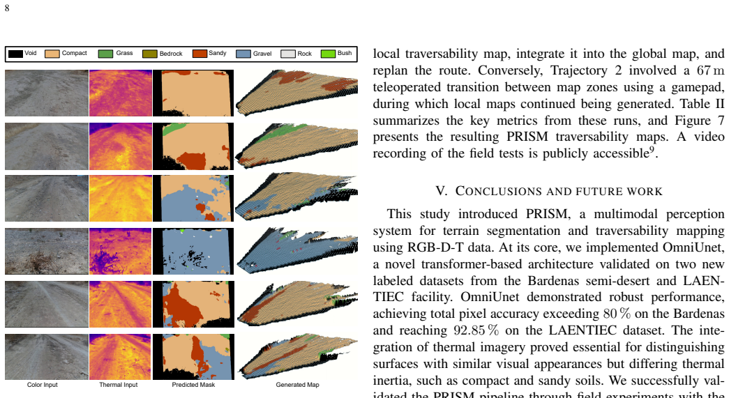
The load-bearing object is OmniUnet, a neural network that fuses RGB, depth, and thermal channels in a single architecture: a vision-transformer backbone with shifted-window attention extracts features across modalities, and a U-Net-style decoder produces per-pixel terrain classes. Around it sit two supporting mechanisms: (1) the image aligner, which back-projects each depth pixel into 3D via the depth camera's intrinsics, transforms to the thermal camera's frame via fixed extrinsics, and re-projects with thermal intrinsics, producing a spatially aligned thermal channel; and (2) the map processor, which converts the class mask and depth-derived elevation into a traversability cost map. The c
What would settle it
Run the same field trajectories with an RGB-D-only segmenter (drop the thermal channel) under identical conditions: if the traversability maps and autonomous completion metrics stay within noise of the RGB-D-T run, the central claim that thermal is essential falls. Also measure reprojection error between depth and thermal edges at known targets; if misalignment exceeds a few pixels, the fused inputs are not in the assumed correspondence.
Extended reading notes
Core claim
The paper's central claim is that a single perception system can fuse RGB, depth, and thermal streams into a traversability cost map on the rover itself, and that this map is sufficient input for autonomous navigation through unstructured terrain. On its own terms: PRISM takes time-synchronized images from a stereo RGB-D camera and a thermal camera, reprojects every depth pixel into the thermal frame using the pinhole model with fixed extrinsics, feeds the aligned five-channel image into OmniUnet — a vision-transformer segmenter with shifted-window attention and U-Net-style decoding — and uses the resulting class mask together with elevation data to build a multilayered digital elevation map
Load-bearing premise
The conclusion that thermal imagery is 'essential' rests on the unmeasured assumption that the fixed-extrinsic pinhole alignment preserves the thermal signal's class-discriminating content and that the hand-labeled Bardenas and LAENTIEC training sets represent the terrain the rover actually meets; no ablation or alignment-error measurement supports it.
Editorial extensions
If this is right
- Autonomous traversal over 124 m in three field trajectories shows the generated maps can be fed directly to a rover's GNC planner; the system replanned every 5 m and completed the autonomous segments without a reported failure.
- An embedded GPU computes the segmentation in about 673 ms per frame and a full map cycle in about 20 s at 0.1 m resolution with a 10 m lookahead — numbers that fit power-constrained rover missions.
- Two public labeled RGB-D-T datasets become available, letting other groups train and compare multimodal terrain segmenters without collecting new field data.
- The finding that compact and sandy soils can be separated by thermal inertia suggests the approach can transfer to environments where optical appearance is ambiguous, including planetary surfaces with strong thermal contrasts.
- The design of the traversability cost function — unknown objects default to obstacles, known classes priced by elevation and surface type — offers a reusable template for other rover navigation stacks.
Reading between the lines
- The paper's conclusion that thermal 'proved essential' (Section V) is not directly demonstrated: there is no ablation that drops the thermal channel. A side-by-side run of the same trajectories with RGB-D only would isolate whether thermal, or the extra alignment and cost machinery, explains the success.
- Because rock detection reaches only 18.40% on the Bardenas dataset (Table I), the safety of the system likely depends more on the elevation/DEM layer and the 'unknown equals obstacle' default than on semantic rock recognition; that division of labor could be tested by removing the elevation check.
- The alignment method assumes fixed extrinsics and uses a thermal resolution lower than the depth resolution; if misalignment degrades class boundaries, segmentation accuracy will fall. A sensitivity test that deliberately introduces alignment error would map how much precision PRISM actually needs.
- On Mars, low atmospheric pressure amplifies thermal contrasts and even supports slip estimation, so the PRISM pipeline — if its terrestrial training transfers — could deliver larger benefits than in the tested Earth environment; that transfer remains untested.
Signed reviews
Editorial analysis
A structured set of objections, weighed in public.
Referee Report
Summary. The paper presents PRISM, a multimodal perception system that fuses RGB, depth, and thermal (RGB-D-T) imagery for semantic terrain segmentation and traversability mapping on an autonomous rover. The pipeline consists of a timestamp-based image merger, a depth-assisted pinhole image aligner, an OmniUnet vision-transformer-based terrain segmenter, and a map processor that builds DEMs and traversability maps. The authors contribute a manually labeled subset of the existing BASEPROD dataset and a new LAENTIEC dataset, train OmniUnet on both (with an RUGD RGB baseline), and validate the full system in field trials at LAENTIEC using the RAT rover, reporting 124 m of autonomous traversal, 0.1 m map resolution, and total pixel accuracy above 80% on both multimodal datasets. The paper concludes that thermal imagery was essential for distinguishing surfaces with similar visual appearance but different thermal inertia, such as compact and sandy soils.
Significance. If the thermal-essentiality claim were established, PRISM would be a valuable public demonstration of a complete RGB-D-T terrain-mapping stack, with two released datasets, open-source ROS2 code, and real field experiments on embedded hardware. The system-level feasibility evidence is credible and useful: 124 m of autonomous driving, deployment on a Jetson Orin Nano, and end-to-end operation with replanning every 5 m are concrete strengths. However, the key causal claim about thermal input is not tested, and the low per-class accuracy on safety-critical classes means the current evidence supports feasibility rather than superiority of thermal fusion. With a controlled ablation, alignment validation, and cross-dataset evaluation, the paper could make a much stronger contribution.
major comments (5)
- [Section V; Table I] The conclusion that 'the integration of thermal imagery proved essential' is unsupported by the reported experiments. Table I contains only RGB-D-T results; there is no RGB-only or RGB-D baseline trained under identical conditions, so the claim that thermal cues distinguish compact and sandy soils is untested. Please add a modality ablation (RGB vs RGB-D vs RGB-D-T) on both datasets, or substantially weaken the conclusion to a claim about the PRISM system as a whole.
- [Section III-B] The thermal-to-depth aligner relies on fixed extrinsic/intrinsic pinhole projection, but the paper reports no calibration procedure, reprojection error, or alignment-quality metric, and no distortion correction for the thermal camera is mentioned. If the fixed transforms are inaccurate, the thermal channel can inject spatially shifted features and degrade segmentation; this is especially relevant because the 'thermal essential' claim assumes the thermal signal is properly co-registered. Please report calibration residuals and, ideally, evaluate segmentation sensitivity to alignment error.
- [Table I] The per-class results for safety-relevant terrain are very low: rock 18.40%, bedrock 28.30%, sandy 26.57% on Bardenas, and gravel 27.04% on LAENTIEC. Since the map processor treats unrecognized objects as obstacles, low recall on these classes can make the traversability map either over-conservative (bloating obstacles) or unsafe (missing rocks), and the paper does not discuss this tradeoff. Please add per-class IoU, confusion analysis, error bars over training runs, and a discussion of the operational consequences.
- [Section IV-B/IV-C; Table I] The field tests used model weights trained on Bardenas ('we selected model weights trained on the Bardenas dataset'), but Table I's LAENTIEC numbers are for the model fine-tuned on LAENTIEC images. No cross-dataset evaluation of the Bardenas-trained model on LAENTIEC is provided, so the segmentation quality actually available during the field runs is unknown. Please report the Bardenas-trained model's accuracy on LAENTIEC (or on the field-run images) and any domain-shift mitigation.
- [Table II] Table II reports distance, number of generated maps, stops, and timing, but no metric that compares navigation with and without thermal input or against a baseline planner. The field trials demonstrate that the system can run end-to-end, but they do not quantify whether the thermal modality changed route choices or improved safety. At minimum, report replanning decisions caused by thermal-based terrain classes, path-length/energy differences, or compare against RGB-D-only maps.
minor comments (6)
- [Abstract; Section I] The abstract calls OmniUnet a 'novel vision transformer-based network' while Section I describes it as 'our previously introduced architecture [34]'. Please clarify the novel contribution of PRISM relative to OmniUnet.
- [Section III-B] 'Pinhole Camera Model (PMC)' should be 'Pinhole Camera Model (PCM)' or rephrase. Also, the arrows in Figure 3a marked 'Direct Intrinsics' and 'Inverse Intrinsics' are confusing because both back-projection and projection are shown.
- [Section IV-B] The RUGD baseline is RGB-only and therefore not directly comparable to the RGB-D-T multimodal results; state its role as a sanity check rather than a multimodal benchmark.
- [Section IV-B; Table I] The text says RUGD contains 'approximately 7,500' images while Table I gives 7,435 total images; align these numbers.
- [Section IV-B] No inter-annotator agreement or labeling protocol is reported for the manually labeled Bardenas subset. Since the labels are a contribution, a brief annotation guideline or agreement metric would help.
- [Section IV-C] The paper reports a full map generation cycle of approximately 20 s and 673 ms for segmentation alone; clarify whether the 20 s includes alignment and map processing and how this relates to the 5 m replan interval.
Circularity Check
No substantive circularity; the central system is grounded in new labeled datasets and field trials, with only a minor non-load-bearing self-citation of the OmniUnet backbone.
full rationale
PRISM's claimed contribution is an end-to-end multimodal mapping pipeline. The core segmentation component is OmniUnet, which is cited to the authors' own prior work [34]; this is a genuine self-citation, and the architecture is central to the paper. However, the paper does not merely re-present that result: it retrains and evaluates OmniUnet on newly labeled Bardenas and LAENTIEC splits (Table I) and demonstrates the full PRISM pipeline in physical field trials (Table II). Those external evaluations provide independent support, so the self-citation is not load-bearing in a circular sense. The thermal-alignment step is a standard pinhole projection using intrinsics and extrinsics; no fitted parameter is renamed as a prediction. The traversability costs are explicit rules applied to segmentation and elevation, not quantities derived from the same data they are used to predict. The conclusion that 'the integration of thermal imagery proved essential' is not backed by an RGB/RGB-D ablation or by alignment-error measurements, and rock detection accuracy is low (18.40% on Bardenas). This is an evidentiary weakness or overclaim about causal contribution, but it is not a circular derivation: the claim is not forced by construction, by self-citation, or by fitting. No uniqueness theorem, imported ansatz, or renaming of a known result is used to make the argument. Therefore the paper is not materially circular; the few self-citations and unproven assertions affect robustness and rigor, not the circularity of the derivation chain.
Assumptions & free parameters
free parameters (8)
- Learning rate =
2e-5
- Batch size =
16
- Training epochs =
50 pre-train / 20 fine-tune
- Train/validation split =
80/20
- Frozen layers during fine-tuning =
first two layers
- Map resolution =
0.1 m
- Replanning interval =
5 m
- Traversability cost values =
not specified
assumptions (6)
- domain assumption Granular sandy soils heat more than compact soils under solar load, providing a traversability-relevant thermal cue.
- domain assumption A pinhole model with fixed intrinsics/extrinsics and no distortion model accurately maps depth pixels to thermal pixels.
- domain assumption Manual semantic labels of the 1,140 Bardenas and 310 LAENTIEC images are correct and representative.
- domain assumption The previously introduced OmniUnet architecture [34] is an appropriate RGB-D-T segmentation backbone.
- domain assumption Weights trained on Bardenas generalize to LAENTIEC summer field conditions.
- domain assumption Completion of autonomous trajectories with scheduled stops demonstrates safe navigation.
Cite this review
Pith. "Pith review of PRISM: Multimodal Terrain Mapping for Rover Navigation in Unstructured Environments." pith.science (2026). https://pith.science/paper/YJETI5M3
@misc{pith2026260716366,
  author       = {Pith},
  title        = {Pith review of: PRISM: Multimodal Terrain Mapping for Rover Navigation in Unstructured Environments},
  year         = {2026},
  howpublished = {\url{https://pith.science/paper/YJETI5M3}},
  note         = {Machine review of arXiv:2607.16366}
}
read the original abstract
Robotic navigation in unstructured environments requires robust situational awareness to safely traverse hazards such as steep slopes and rocky terrain. To address this challenge, perception systems increasingly rely on multimodal sensor fusion. Specifically, integrating thermal imagery with standard optical and depth sensors enhances terrain differentiation, directly improving the reliability of mapping algorithms. This paper presents PRISM, a multimodal perception system for terrain mapping in unstructured settings. PRISM leverages a custom sensor suite to capture aligned RGB, depth, and thermal (RGB-D-T) imagery. At its core is OmniUnet, a novel vision transformer-based network specifically designed for multimodal semantic terrain segmentation. We validated the proposed system using two newly annotated datasets (BASEPROD and LAENTIEC) and demonstrate its real-world applicability through physical field experiments. Deployed on a resource-constrained embedded computer, PRISM efficiently generates traversability maps that directly enable autonomous navigation via a rover's Guidance, Navigation, and Control (GNC) subsystem.
Figures


Figures from the paper (4 more)


Reference graph
Works this paper leans on
-
[1]
Guid- ance, navigation, and control technology assessment for future planetary science missions,
M. B. Quadrelli, L. J. Wood, J. E. Riedel, M. C. McHenry, M. Aung, L. A. Cangahuala, R. A. V olpe, P. M. Beauchamp, and J. A. Cutts, “Guid- ance, navigation, and control technology assessment for future planetary science missions,”Journal of Guidance, Control, and Dynamics, vol. 38, no. 7, pp. 1165–1186, 2015
2015
-
[2]
Challenges and solutions for autonomous ground robot scene understanding and navigation in unstructured outdoor environments: A review,
L. Wijayathunga, A. Rassau, and D. Chai, “Challenges and solutions for autonomous ground robot scene understanding and navigation in unstructured outdoor environments: A review,”Applied Sciences, vol. 13, no. 17, 2023
2023
-
[3]
Slippage estimation and compensation for planetary exploration rovers. State of the art and future challenges,
R. Gonzalez and K. Iagnemma, “Slippage estimation and compensation for planetary exploration rovers. State of the art and future challenges,” Journal of Field Robotics, vol. 35, no. 4, pp. 564–577, 2018
2018
-
[4]
A survey on terrain traversability analysis for autonomous ground vehicles: Methods, sensors, and challenges,
P. Borges, T. Peynot, S. Liang, B. Arain, M. Wildie, M. Minareci, S. Lichman, G. Samvedi, I. Sa, N. Hudsonet al., “A survey on terrain traversability analysis for autonomous ground vehicles: Methods, sensors, and challenges,”Field Robot, vol. 2, no. 1, pp. 1567–1627, 2022
2022
-
[5]
U-net: Convolutional networks for biomedical image segmentation,
O. Ronneberger, P. Fischer, and T. Brox, “U-net: Convolutional networks for biomedical image segmentation,” inMedical Image Computing and Computer-Assisted Intervention, 2015, pp. 234–241
2015
-
[6]
Mask r-cnn,
K. He, G. Gkioxari, P. Doll ´ar, and R. Girshick, “Mask r-cnn,” inIEEE international conference on computer vision, 2017, pp. 2961–2969
2017
-
[7]
Object detection using yolo: Challenges, architectural successors, datasets and applications,
T. Diwan, G. Anirudh, and J. V . Tembhurne, “Object detection using yolo: Challenges, architectural successors, datasets and applications,” multimedia Tools and Applications, vol. 82, no. 6, pp. 9243–9275, 2023. 9https://youtu.be/6vFK4U6ZmFI 9
2023
-
[8]
An image is worth 16x16 words: Transformers for image recognition at scale,
A. Kolesnikov, A. Dosovitskiy, D. Weissenborn, G. Heigold, J. Uszkoreit, L. Beyer, M. Minderer, M. Dehghani, N. Houlsby, S. Gelly, T. Un- terthiner, and X. Zhai, “An image is worth 16x16 words: Transformers for image recognition at scale,” inInternational Conference on Computer Vision (ICCV), 2021
2021
Show all 55 references
-
[9]
Swin-unet: Unet-like pure transformer for medical image segmenta- tion,
H. Cao, Y . Wang, J. Chen, D. Jiang, X. Zhang, Q. Tian, and M. Wang, “Swin-unet: Unet-like pure transformer for medical image segmenta- tion,” inEuropean conference on computer vision, 2022, pp. 205–218
2022
-
[10]
A survey of visual transformers,
Y . Liu, Y . Zhang, Y . Wang, F. Hou, J. Yuan, J. Tian, Y . Zhang, Z. Shi, J. Fan, and Z. He, “A survey of visual transformers,”IEEE Transactions on Neural Networks and Learning Systems, 2023
2023
-
[11]
Unetformer: A unet-like transformer for efficient semantic segmentation of remote sensing urban scene imagery,
L. Wang, R. Li, C. Zhang, S. Fang, C. Duan, X. Meng, and P. M. Atkinson, “Unetformer: A unet-like transformer for efficient semantic segmentation of remote sensing urban scene imagery,”ISPRS Journal of Photogrammetry and Remote Sensing, vol. 190, pp. 196–214, 2022
2022
-
[12]
Mapping for planetary rovers from terramechanics perspective,
R. Zhou, L. Ding, H. Gao, W. Feng, Z. Deng, and N. Li, “Mapping for planetary rovers from terramechanics perspective,” in2019 IEEE/RSJ International Conference on Intelligent Robots and Systems (IROS), 2019, pp. 1869–1874
2019
-
[13]
Maars: Machine learning- based analytics for automated rover systems,
M. Ono, B. Rothrock, K. Otsu, S. Higa, Y . Iwashita, A. Didier, T. Islam, C. Laporte, V . Sun, K. Stacket al., “Maars: Machine learning- based analytics for automated rover systems,” in2020 IEEE aerospace conference, 2020, pp. 1–17
2020
-
[14]
Self-reliant rovers for increased mission productivity,
D. Gaines, G. Doran, M. Paton, B. Rothrock, J. Russino, R. Mackey, R. Anderson, R. Francis, C. Joswig, H. Justiceet al., “Self-reliant rovers for increased mission productivity,”Journal of Field Robotics, vol. 37, no. 7, pp. 1171–1196, 2020
2020
-
[15]
Mergenet: A deep net architecture for small obstacle discovery,
K. Gupta, S. A. Javed, V . Gandhi, and K. M. Krishna, “Mergenet: A deep net architecture for small obstacle discovery,” in2018 IEEE International Conference on Robotics and Automation (ICRA), 2018, pp. 5856–5862
2018
-
[16]
Small obstacle avoidance based on RGB- D semantic segmentation,
M. Hua, Y . Nan, and S. Lian, “Small obstacle avoidance based on RGB- D semantic segmentation,” inProceedings of the IEEE/CVF interna- tional conference on computer vision workshops, 2019, pp. 1–9
2019
-
[17]
Real-time fusion network for RGB-D semantic segmentation incorporating unexpected obstacle detection for road-driving images,
L. Sun, K. Yang, X. Hu, W. Hu, and K. Wang, “Real-time fusion network for RGB-D semantic segmentation incorporating unexpected obstacle detection for road-driving images,”IEEE robotics and automation letters, vol. 5, no. 4, pp. 5558–5565, 2020
2020
-
[18]
Cross-modal attention fusion network for RGB-D semantic segmentation,
Q. Zhao, Y . Wan, J. Xu, and L. Fang, “Cross-modal attention fusion network for RGB-D semantic segmentation,”Neurocomputing, vol. 548, p. 126389, 2023
2023
-
[19]
Heatnet: Bridging the day-night domain gap in semantic segmentation with thermal images,
J. Vertens, J. Z ¨urn, and W. Burgard, “Heatnet: Bridging the day-night domain gap in semantic segmentation with thermal images,” inIEEE/RSJ International Conference on Intelligent Robots and Systems (IROS), 2020, pp. 8461–8468
2020
-
[20]
DaCFN: divide-and-conquer fusion network for RGB-T object detection,
B. Wang, H. Zhao, and Y . Zhuang, “DaCFN: divide-and-conquer fusion network for RGB-T object detection,”International Journal of Machine Learning and Cybernetics, pp. 1–14, 2023
2023
-
[21]
CMX: Cross-modal fusion for RGB-X semantic segmentation with transformers,
J. Zhang, H. Liu, K. Yang, X. Hu, R. Liu, and R. Stiefelhagen, “CMX: Cross-modal fusion for RGB-X semantic segmentation with transformers,”IEEE Transactions on Intelligent Transportation Systems, 2023
2023
-
[22]
URTSegNet: A real-time segmentation network of unstructured road at night based on thermal infrared images for autonomous robot system,
X. Liu, J. Wang, and J. Li, “URTSegNet: A real-time segmentation network of unstructured road at night based on thermal infrared images for autonomous robot system,”Control Engineering Practice, vol. 137, p. 105560, 2023
2023
-
[23]
Perception and sensing for autonomous vehicles under adverse weather conditions: A survey,
Y . Zhang, A. Carballo, H. Yang, and K. Takeda, “Perception and sensing for autonomous vehicles under adverse weather conditions: A survey,” ISPRS Journal of Photogrammetry and Remote Sensing, vol. 196, pp. 146–177, 2023
2023
-
[24]
First results of the ROBEX analogue mission campaign: Robotic deployment of seismic networks for future lunar missions,
A. Wedler, M. Vayugundla, H. Lehner, P. Lehner, M. J. Schuster, S. G. Brunner, W. St¨urzl, A. D ¨omel, H. Gmeiner, B. V odermayeret al., “First results of the ROBEX analogue mission campaign: Robotic deployment of seismic networks for future lunar missions,” inInternational As...
2017
-
[25]
Mars Science Laboratory mission and science investigation,
J. P. Grotzinger, J. Crisp, A. R. Vasavada, R. C. Anderson, C. J. Baker, R. Barry, D. F. Blake, P. Conrad, K. S. Edgett, B. Ferdowskiet al., “Mars Science Laboratory mission and science investigation,”Space science reviews, vol. 170, pp. 5–56, 2012
2012
-
[26]
The Mars 2020 Perseverance rover mast camera zoom (Mastcam-Z) multispectral, stereoscopic imaging investigation,
J. Bell, J. Maki, G. Mehall, M. Ravine, M. Caplinger, Z. Bailey, S. Brylow, J. Schaffner, K. Kinch, M. Madsenet al., “The Mars 2020 Perseverance rover mast camera zoom (Mastcam-Z) multispectral, stereoscopic imaging investigation,”Space science reviews, vol. 217, pp. 1–40, 2021
2020
-
[27]
Hybrid terrain traversabil- ity analysis in off-road environments,
T. H. Y . Leung, D. Ignatyev, and A. Zolotas, “Hybrid terrain traversabil- ity analysis in off-road environments,” in2022 8th International Con- ference on Automation, Robotics and Applications (ICARA), 2022, pp. 50–56
2022
-
[28]
Off-road drivable area detection: A learning-based approach exploiting lidar reflection texture information,
C. Zhong, B. Li, and T. Wu, “Off-road drivable area detection: A learning-based approach exploiting lidar reflection texture information,” Remote Sensing, vol. 15, no. 1, p. 27, 2022
2022
-
[29]
Ufo: Uncertainty aware lidar-image fusion for off-road semantic terrain map estimation,
O. Kim, J. Seo, S. Ahn, and C. H. Kim, “Ufo: Uncertainty aware lidar-image fusion for off-road semantic terrain map estimation,”arXiv preprint arXiv:2403.02642, 2024
2024 arXiv
-
[30]
Thermal vision, moisture content, and vegetation in the context of off-road mobile robots,
R. Gonzalez, A. Lopez, and K. Iagnemma, “Thermal vision, moisture content, and vegetation in the context of off-road mobile robots,”Journal of Terramechanics, vol. 70, pp. 35–48, 2017
2017
-
[31]
Virtual IR sensing for planetary rovers: Improved terrain classification and thermal inertia estimation,
Y . Iwashita, K. Nakashima, J. Gatto, S. Higa, A. Stoica, N. Khoo, and R. Kurazume, “Virtual IR sensing for planetary rovers: Improved terrain classification and thermal inertia estimation,”IEEE Robotics and Automation Letters, vol. 5, no. 4, pp. 6302–6309, 2020
2020
-
[32]
Improving slip prediction on Mars using thermal inertia measurements,
C. Cunningham, I. A. Nesnas, and W. L. Whittaker, “Improving slip prediction on Mars using thermal inertia measurements,”Autonomous Robots, vol. 43, pp. 503–521, 2019
2019
-
[33]
Thermal imagery for rover soil assessment using a multipurpose environmental chamber under simulated Mars conditions,
R. Castilla-Arquillo, A. Mandow, C. J. P ´erez-del Pulgar, C. ´Alvarez- Llamas, J. M. Vadillo, and J. Laserna, “Thermal imagery for rover soil assessment using a multipurpose environmental chamber under simulated Mars conditions,”IEEE Transactions on Instrumentation and Measur...
2024
-
[34]
OmniUnet: A multimodal network for unstructured terrain segmentation on planetary rovers using RGB, depth, and thermal imagery,
R. Castilla-Arquillo, C. J. P ´erez-Del-Pulgar, L. Gerdes, A. Garcia- Cerezo, and M. Olivares-Mendez, “OmniUnet: A multimodal network for unstructured terrain segmentation on planetary rovers using RGB, depth, and thermal imagery,” in2025 International Conference on Space Robo...
2025
-
[35]
A RUGD dataset for autonomous navigation and visual perception in unstructured outdoor environments,
M. Wigness, S. Eum, J. G. Rogers, D. Han, and H. Kwon, “A RUGD dataset for autonomous navigation and visual perception in unstructured outdoor environments,” in2019 IEEE/RSJ International Conference on Intelligent Robots and Systems (IROS), 2019, pp. 5000–5007
2019
-
[36]
Rellis-3d dataset: Data, benchmarks and analysis,
P. Jiang, P. Osteen, M. Wigness, and S. Saripalli, “Rellis-3d dataset: Data, benchmarks and analysis,” in2021 IEEE international conference on robotics and automation (ICRA), 2021, pp. 1110–1116
2021
-
[37]
Cat: Cavs traversability dataset for off-road autonomous driving,
S. Sharma, L. Dabbiru, T. Hannis, G. Mason, D. W. Carruth, M. Doude, C. Goodin, C. Hudson, S. Ozier, J. E. Ballet al., “Cat: Cavs traversability dataset for off-road autonomous driving,”IEEE Access, vol. 10, pp. 24 759–24 768, 2022
2022
-
[38]
BASEPROD: The Bardenas semi-desert planetary rover dataset,
L. Gerdes, T. Wiese, R. Castilla Arquillo, L. Bielenberg, M. Azkarate, H. Leblond, F. Wilting, J. Ortega Cort ´es, A. Bernal, S. Palancoet al., “BASEPROD: The Bardenas semi-desert planetary rover dataset,”Sci- entific Data, vol. 11, no. 1, p. 1054, 2024
2024
-
[39]
Design, Testing, and Evolution of Mars Rover Testbeds: European Space Agency Planetary Exploration,
M. Azkarate, L. Gerdes, T. Wiese, M. Zwick, M. Pagnamenta, J. Hidalgo-Carrio, P. Poulakis, and C. J. Perez-del Pulgar, “Design, Testing, and Evolution of Mars Rover Testbeds: European Space Agency Planetary Exploration,”IEEE Robotics and Automation Magazine, vol. 29, no. 3, pp...
2022
-
[40]
Improving autonomous rover guidance in round-trip missions using a dynamic cost map,
G. J. Paz-Delgado, M. Azkarate, J. R. S ´anchez-Ib´a˜nez, C. J. P ´erez-del Pulgar, L. Gerdes, and A. J. Garc ´ıa-Cerezo, “Improving autonomous rover guidance in round-trip missions using a dynamic cost map,” in 2020 IEEE/RSJ International Conference on Intelligent Robots and ...
2020
-
[41]
Advancements in autonomous mobility of planetary wheeled mobile robots: A review,
M. Zarei and R. Chhabra, “Advancements in autonomous mobility of planetary wheeled mobile robots: A review,”Frontiers in Space Technologies, vol. 3, p. 1080291, 2022
2022
-
[42]
Simultaneous localization and mapping,
C. Stachniss, J. J. Leonard, and S. Thrun, “Simultaneous localization and mapping,” inSpringer handbook of robotics, 2016, pp. 1153–1176
2016
-
[43]
Path planning for autonomous mobile robots: A review,
J. R. S ´anchez-Ib´a˜nez, C. J. P´erez-del Pulgar, and A. Garc´ıa-Cerezo, “Path planning for autonomous mobile robots: A review,”Sensors, vol. 21, no. 23, p. 7898, 2021
2021
-
[44]
Dynamic path planning for reconfigurable rovers using a multi-layered grid,
J. R. S ´anchez-Ib´anez, C. J. Perez-del Pulgar, M. Azkarate, L. Gerdes, and A. Garc´ıa-Cerezo, “Dynamic path planning for reconfigurable rovers using a multi-layered grid,”Engineering Applications of Artificial Intel- ligence, vol. 86, pp. 32–42, 2019
2019
-
[45]
First results in robot road-following
R. S. Wallace, A. Stentz, C. E. Thorpe, H. P. Moravec, W. Whittaker, T. Kanadeet al., “First results in robot road-following.” inIJCAI, vol. 2, 1985, pp. 1089–1095
1985
-
[46]
Efficient autonomous navigation for planetary rovers with limited resources,
L. Gerdes, M. Azkarate, J. S ´anchez-Ib´a˜nez, L. Joudrier, and C. Perez- del Pulgar, “Efficient autonomous navigation for planetary rovers with limited resources,”Journal of Field Robotics, vol. 37, no. 7, pp. 1153– 1170, 2020
2020
-
[47]
A kinematic-based rough terrain control for traction and energy saving of an exploration rover,
J. Kim and J. Lee, “A kinematic-based rough terrain control for traction and energy saving of an exploration rover,” in2016 IEEE/RSJ Interna- tional Conference on Intelligent Robots and Systems (IROS). IEEE, 2016, pp. 3595–3600. 10
2016
-
[48]
Model predictive control of a novel wheeled–legged planetary rover for trajectory tracking,
J. He, Y . Sun, L. Yang, and F. Gao, “Model predictive control of a novel wheeled–legged planetary rover for trajectory tracking,”Sensors, vol. 22, no. 11, p. 4164, 2022
2022
-
[49]
Omnivore: A single model for many visual modalities,
R. Girdhar, M. Singh, N. Ravi, L. van der Maaten, A. Joulin, and I. Misra, “Omnivore: A single model for many visual modalities,” in IEEE/CVF Conference on Computer Vision and Pattern Recognition, 2022, pp. 16 102–16 112
2022
-
[50]
Design and realization of a rover autonomy testbed,
A. Medina, L. Mollinedo, K. Kapellos, C. Crespo, and P. Poulakis, “Design and realization of a rover autonomy testbed,” inESA Workshop on Advanced Space Technologies for Robotics and Automation (ASTRA), 2015
2015
-
[51]
The marathon 2: A navigation system,
S. Macenski, F. Martin, R. White, and J. Gin ´es Clavero, “The marathon 2: A navigation system,” in2020 IEEE/RSJ International Conference on Intelligent Robots and Systems (IROS), 2020
2020
-
[52]
Dynamic path planning for reconfigurable rovers using a multi-layered grid,
J. S ´anchez-Ib´anez, C. P ´erez-del Pulgar, M. Azkarate, L. Gerdes, and A. Garc ´ıa-Cerezo, “Dynamic path planning for reconfigurable rovers using a multi-layered grid,”Engineering Applications of Artificial In- telligence, vol. 86, pp. 32–42, 2019
2019
-
[53]
Fusion of Color, Depth, and Thermal Modalities for Rover Navigation in Unstructured Environments,
R. Castilla Arquillo, C. J. del Pulgar Mancebo, L. Gerdes, A. Garc ´ıa- Cerezo, and A. Mart´ınez Petersen, “Fusion of Color, Depth, and Thermal Modalities for Rover Navigation in Unstructured Environments,” may
-
[54]
RGBDT dataset LAENTIEC experimental area,
I. Naranjo-Ortega, R. Castilla-Arquillo, and C. J. P. del Pulgar-Mancebo, “RGBDT dataset LAENTIEC experimental area,” May 2023. [Online]. Available: https://doi.org/10.5281/zenodo.8032971
2023 doi
-
[2025]
Available: https://doi.org/10.5281/zenodo.15496884
[Online]. Available: https://doi.org/10.5281/zenodo.15496884
Reviewed August 1, 2026 · model on record in the stance chip above.
Discussion (0). Continue with ORCID to comment.