REVIEW 2 major objections 4 minor 2 references
Earth as an Exoplanet: A Two-dimensional Alien Map
T0 review · 2 major / 4 minor · reviewed 2026-08-14 · deepseek-v4-flash
Pith's one-line read The authors show the first two-dimensional map of a cloudy Earth-like planet reconstructed from single-point light curves by inverting the second principal component of disk-integrated reflectance.
desk verdict First 2D surface map of Earth from single-point light curves is a genuine advance, but the regularization is tuned to known geography and a PC1 null control is missing. read the letter →
The pith
A machine-rendered reading of the paper's core claim, the machinery that carries it, and where it could break.
The reading
What carries the argument
The load-bearing object is the second principal component (PC2) of the scaled, disk-integrated ten-channel reflectance time series. Because both the channel scaling and the singular value decomposition are linear, the disk-averaged PC2 at each time step can be written as a weighted sum of per-pixel PC2 values, with weights proportional to the product of the cosines of the solar and spacecraft zenith angles and zero outside the sunlit hemisphere (Equations 2 and 3). Solving this linear system with an L2-regularization penalty and HEALPix pixelation converts the PC2 time series into the surface map shown in Figure 4a, while the companion GBRT analysis establishes that PC2, not PC1, is the component tied to the land fraction.
What would settle it
Take the same ~10,000 DSCOVR/EPIC frames and build synthetic light curves from a known surface albedo map plus observed cloud fields with surface-correlated clouds removed; if the same SVD-plus-inversion pipeline no longer recovers the input continents with $r^2\approx0.91$ against land fraction, the PC2 surface signal is partly a cloud artifact rather than a clean surface measurement.
Extended reading notes
Core claim
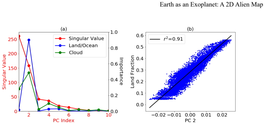
The central discovery is that when Earth's multiwavelength images are collapsed to point-source light curves and each channel is normalized to zero mean and unit variance, the second principal component carries surface structure instead of cloud noise. Its time series tracks the sunlit land fraction with $r^2=0.91$, and a regularized linear inversion of this component, assuming only Lambertian reflection and known observing geometry, recovers all major continents. The paper therefore demonstrates the first two-dimensional surface map of a cloudy, Earth-like planet reconstructed entirely from single-point light curves, with no assumed surface spectral features.
Load-bearing premise
The reconstruction assumes each surface pixel reflects like a Lambertian disk lit by uniform, known sunlight, and that surface-correlated clouds do not systematically skew the second principal component; if either assumption fails, the recovered continents could be artifacts.
Editorial extensions
If this is right
- For an Earth-like exoplanet with similar cloud variability, the two leading principal components should carry the same split: an irregular cloud component and a periodic surface component that can be inverted into a map using estimated rotation period, obliquity, and solstice timing.
- The surface component is not specific to land and ocean; any two large-albedo-contrast surface types with non-uniform global distribution would occupy one principal component and become mappable.
- Because the retrieved map is insensitive to order-of-magnitude changes in the regularization parameter near the chosen value, the same reconstruction recipe can be transferred to other planets with adjusted pixel numbers and observation counts.
- Latitudes far from the equator will be harder to map for an observer near the planet's equatorial plane because the weighting terms favor low-latitude pixels, and the recovered map carries roughly 10% per-pixel uncertainty there.
Reading between the lines
- An explicit test is to synthesize light curves from a known albedo map overlaid with real cloud fields and run the same pipeline; if the recovered continents persist in cloud-free synthetic data, the PC2 signal is robust surface information rather than a cloud artifact.
- The paper's dependence on known viewing geometry is less restrictive than it appears: the same PC2 time series that yields the map can supply rotation period and solstice phase, so a future map could be produced from the light curve alone once obliquity is constrained.
- Applying the same linear inversion to PC1 instead of PC2 should produce a map of time-mean cloud distribution; comparing the two maps would separate cloud climatology from surface albedo and could diagnose how much surface-correlated cloudiness biases the continents.
Signed reviews
Editorial analysis
A structured set of objections, weighed in public.
Referee Report
Summary. The paper treats ~9,740 DSCOVR/EPIC disk-integrated, multi-wavelength reflectance measurements of Earth (2016-2017) as the light curves of a proxy exoplanet. After per-channel z-scoring, singular value decomposition (SVD) yields two dominant principal components (PCs) capturing 96.2% of the variance. The authors report that PC2 correlates strongly with the disk-averaged land fraction (r^2 = 0.91) and is assigned surface-related information, while PC1 primarily captures surface-independent clouds. Assuming known viewing geometry and Lambertian reflection, they formulate the map construction as a regularized linear inversion of the PC2 time series, solving X = (W^T W + lambda I)^-1 W^T V, and present the resulting two-dimensional surface map of Earth (Figure 4a) as the first such map reconstructed from single-point light curves without assuming surface spectral properties. The regularization parameter lambda = 10^-3 is chosen using the known Earth ground truth via synthetic-data tests, and the coastline is drawn at the median of the reconstructed PC2 field. An uncertainty estimate based on Gaussian observation noise is given in Appendix c.
Significance. If the result holds, this is a valuable proof-of-concept for exoplanet surface mapping: it demonstrates on real data that SVD of disk-integrated, spectrally resolved light curves can separate surface from cloud contributions without template surface spectra, and that a geometry-weighted linear inversion can recover continental-scale structure. The use of independent external labels (GSHHG land fraction and MODIS cloud fraction) for validation is a notable strength, as is the explicit synthetic-data test in Figure S2 showing that the inversion operator can recover continents from the true land-fraction time series. The paper is also transparent about its Lambertian assumption and about the ground-truth-based choice of lambda. However, the claim in the abstract is stronger than what is demonstrated: the map depends on a regularization parameter selected with knowledge of the answer, and the absence of a null control leaves open the possibility that the recovered continents are not unique to the surface-correlated content of PC2.
major comments (2)
- [Section 3 / Appendix b] The abstract and Section 3 claim that the 2D surface map is reconstructed 'without any assumptions of its spectral properties' and present it as a baseline for exoplanets. However, the regularization parameter lambda is explicitly selected using ground truth: Section 3 states 'We select the value of lambda based on the ground truth of Earth's surface map,' and Appendix b confirms that lambda = 10^-3 was chosen by comparing synthetic recovered maps with the known land/ocean map. This is a use of the answer to tune the inversion. Even though Figures S2-S3 show the map is not highly sensitive to lambda over an order of magnitude, the headline claim should be qualified: the map is not fully assumption-free, and for exoplanets where no ground truth exists the paper states that the choice of lambda 'becomes arbitrary.' A self-calibrating selection criterion (e.g., L-curve or cross-validation using only the observed light curves) would be needed to support the generalization claim.
- [Section 3 / Appendix b] The paper lacks a null control for the inversion pipeline. The identical regularized linear inversion is never applied to PC1, the component interpreted as surface-independent clouds, nor to a synthetic time series with the same periodic structure but no spatial surface signal. Without such a control, the recovery of continents in Figure 4a could in principle be an artifact of the geometry-weighted linear operator W and the L2 regularization applied to any sufficiently smooth or periodic time series, rather than evidence that PC2 specifically encodes surface geography. The synthetic test in Figure S2 is a useful validation of the linear operator, but it feeds the true land-fraction time series into the inversion and therefore does not discriminate between surface signal and other spatially structured or periodic signals. I request that the authors apply the same inversion to PC1 and to a null time series (e.g., a shuffled PC2 or a PC1 with matching periodicity) and show the resulting maps.
minor comments (4)
- [Section 4] The sentence 'the surface-independent clouds contribute 70.3% of the total variance of scaled light curves; the contribution of the surface is 25.9%' appears to equate the variance of PC1 with surface-independent clouds and the variance of PC2 with surface alone. This is inconsistent with the paper's own statement that PC2 also contains surface-correlated clouds and that PC2 has a substantial importance weight (0.49) for the cloud fraction. The 25.9% figure should be described as the variance carried by PC2, not purely by the surface, or the decomposition should be revised.
- [References] In Section 4, the in-text citation 'Fujii et al. (2017)' does not match the reference list, which lists 'Cowan N.B., & Fujii Y. 2017, Mapping Exoplanets.' Please correct the citation to Cowan & Fujii (2017) or add the appropriate Fujii et al. reference.
- [Appendix c] The uncertainty estimate in Equation (8) uses T-P as the degrees of freedom, but for ridge regression the effective degrees of freedom should be trace((W^T W + lambda I)^-1 W^T W), which is smaller than P for lambda > 0. The current formula may overestimate the noise variance; more importantly, the reported uncertainty accounts only for Gaussian observation noise and not for the dominant model errors from the Lambertian approximation and surface-correlated cloud contamination. The text should state that the ~10% uncertainty is a lower bound.
- [Section 3 / Figure 4] The choice of the median value of the PC2 field as the coastline is motivated by the assumption that the overall land fraction is unknown, but it means the reconstructed map always produces a 50% land fraction by construction. Since the true Earth is 29% land, this choice could bias the visual comparison with the ground truth in Figure 4b; a brief discussion of how the map would change if the land fraction were constrained would be helpful.
Circularity Check
No significant circularity: PC2 is derived from reflectance by SVD, validated against independent labels, and the map inversion is a disclosed linear identity with only a scalar regularization parameter calibrated on ground truth.
full rationale
The central claim is that disk-integrated, z-scored EPIC reflectance time series, when decomposed by SVD, yield a second principal component whose time series encodes surface geography, and that a regularized linear inversion of PC2 with known viewing geometry produces a 2D surface map. This chain is not circular. PC2 is computed directly from reflectance data; the identification of PC2 with surface features is validated against external labels (land fraction from GSHHG, cloud fraction from MODIS) rather than fitted from them. The map inversion in Appendix b is an exact linear identity: because scaling is affine and SVD projection is linear, PC2(t)=Σ_i c_i z_i(t)=Σ_p w_{t,p} x_p by construction, where x_p is a genuine per-pixel quantity; the inversion recovers a spatial map rather than renaming the input labels. The only point where ground truth enters is the scalar ridge parameter λ, which the paper explicitly says is selected using the known Earth map ("We select the value of λ based on the ground truth of Earth's surface map."). This is disclosed model calibration, not a fitted prediction, and it does not force the spatial structure of the recovered map, which remains determined by PC2. The Lambertian assumption, the known-geometry assumption, and the absence of a PC1 null control are real validation limitations but are not circularity. Self-citations (Jiang et al. 2018 for the DSCOVR dataset, Li et al. 2019 for glint) are data and support citations anchored in public observations, not load-bearing uniqueness claims. No step in the stated derivation reduces by definition to its own inputs.
Assumptions & free parameters
free parameters (2)
- Regularization parameter lambda =
10^-3
- GBRT hyperparameters =
250 trees, depth 5, max nodes 20, min node size 100
assumptions (5)
- domain assumption The surface of the proxy exoplanet acts as a Lambertian reflector with uniform, known solar flux.
- domain assumption The viewing geometry is known exactly from DSCOVR navigation data.
- ad hoc to paper The disk-integrated PC2 time series is a linear mixture of per-pixel PC2 values with weights determined purely by geometry.
- domain assumption Residual noise in the PC2 time series is Gaussian with covariance sigma squared times the identity.
- domain assumption Surface-correlated clouds and surface features are encoded in the same principal component and do not bias the map.
Cite this review
Pith. "Pith review of Earth as an Exoplanet: A Two-dimensional Alien Map." pith.science (2026). https://pith.science/paper/2U2GGJ7T
@misc{pith2026190804350,
  author       = {Pith},
  title        = {Pith review of: Earth as an Exoplanet: A Two-dimensional Alien Map},
  year         = {2026},
  howpublished = {\url{https://pith.science/paper/2U2GGJ7T}},
  note         = {Machine review of arXiv:1908.04350}
}
read the original abstract
Resolving spatially-varying exoplanet features from single-point light curves is essential for determining whether Earth-like worlds harbor geological features and/or climate systems that influence habitability. To evaluate the feasibility and requirements of this spatial feature resolving problem, we present an analysis of multi-wavelength single-point light curves of Earth, where it plays the role of a proxy exoplanet. Here, ~10,000 DSCOVR/EPIC frames collected over a two-year period were integrated over the Earth's disk to yield a spectrally-dependent point source and analyzed using singular value decomposition. We found that, between the two dominant principal components (PCs), the second PC contains surface-related features of the planet, while the first PC mainly includes cloud information. We present the first two-dimensional (2D) surface map of Earth reconstructed from light curve observations without any assumptions of its spectral properties. This study serves as a baseline for reconstructing the surface features of Earth-like exoplanets in the future.
Figures


Figures from the paper (1 more)

Reference graph
Works this paper leans on
-
[1]
Campbell, B., Walker, G. A. H., & Yang, S. 1988, ApJ, 331, 902 Cowan, N. B., Agol, E., Meadows, V . S., et al. 2009, ApJ, 700, 915 Cowan, N. B., & Strait, T. E. 2013, ApJ, 765, L17 Cowan, N. B., Robinson, T., Livengood, T. A., et al. 2011, ApJ, 731, 76 Cowan N.B., & Fujii Y . 2017, Mapping Exoplanets. In: Deeg H., Belmonte J. (eds) Handbook of Exoplanets....
1988
-
[2015]
MODIS Atmosphere L3 Daily Product. Earth as an Exoplanet: A 2D Alien Map 21 doi:10.5067/MODIS/MOD08_D3.006; doi:10.5067/MODIS/MYD08_D3.006 Sagan, C., Thompson, W. R., Carlson, R., et al. 1993, Nature, 365, 715 Schwartz, J. C., Sekowski, C., Haggard, H. M., et al. 2016, MNRAS, 457, 926 Wessel, P., & Smith, W. H. F. 1996, JGR, 101, 8741
Reviewed August 14, 2026 · model on record in the stance chip above.
Discussion (0). Continue with ORCID to comment.