REVIEW 3 major objections 5 minor 25 references
Robotics Under Construction: Challenges on Job Sites
T0 review · 3 major / 5 minor · reviewed 2026-08-06 · deepseek-v4-flash
Pith's one-line read The paper argues that an autonomous payload transport system built from off-the-shelf components on a Komatsu CD110R-3 crawler carrier is a viable first step toward fully unmanned construction sites, with terrain change, dust, and sensor…
desk verdict A candid, well-scoped field report from Earthbrain/Komatsu on autonomous crawler hauling; the construction-site lessons are useful, but the FMS safety case and missing quantitative results keep it from being a research contribution. read the letter →
The pith
A machine-rendered reading of the paper's core claim, the machinery that carries it, and where it could break.
The reading
What carries the argument
The central object is the FMS-ACS control loop. The fleet management system (FMS) defines operational zones, plans global paths with the Reeds-Shepp algorithm in two-dimensional space, approximates every moving object as a safety-margin circle, and issues pause commands when GNSS positions of machines or personnel intrude into protected zones; it also monitors heartbeats and triggers remote stops. The autonomous control system (ACS) executes the resulting missions: it fuses MEMS IMU data with RTK-GNSS for state estimation, uses the Pure Pursuit algorithm for lateral path following while keeping goal error below 50 cm, and a PID controller for upper-body rotation. Supporting perception experiments use GLIM for LiDAR-inertial SLAM mapping, PIDNet for camera segmentation, and Fast Segmentation or Point Transformer V3 for LiDAR ground segmentation.
What would settle it
A decisive field experiment would operate the full FMS-ACS loop on an active site while a person without a GNSS tag walks into a protected zone; if the vehicle does not receive a pause command in time to stop before contact, and relies instead on a manual remote stop, the paper's implicit safety claim fails.
Extended reading notes
Core claim
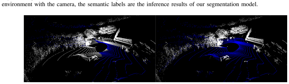
The paper's central claim is that automating the material-transport leg of construction work on a crawler carrier is a viable initial step toward fully unmanned job sites, and that the main obstacles are environmental rather than algorithmic. It shows an integration of existing components—RTK-GNSS and IMU for state estimation, Reeds-Shepp planning, Pure Pursuit control, and a fleet management system that pauses vehicles when GNSS-tracked objects enter protected zones—supported by simulation tests in a replica of a real site and by field experiments in SLAM mapping and semantic segmentation. From those experiments the authors identify three bottlenecks: navigation in terrain that changes faster than maps can refresh, perception under fugitive dust and transient objects such as cones and reshaped dirt piles, and sensor mounting that must balance blind spots, mud, occlusion by moving parts, and vibration.
Load-bearing premise
The safety case depends on every person and machine on the site carrying a functioning GNSS tag whose position reaches the fleet management system in time, so that an intrusion triggers a pause command before contact.
Editorial extensions
If this is right
- Transport tasks can be automated on construction sites with currently available autonomous-driving components, giving an early productivity gain and a stream of real operational data.
- Map freshness becomes a hard operational requirement: global maps must be updated frequently, possibly hourly, or local mapping must adapt, because the machines themselves reshape the ground.
- Perception systems must distinguish temporary features such as cones, survey equipment, dust clouds, and reshaped dirt piles from permanent obstacles, or navigation will be either unsafe or inefficient.
- Sensor placement is a first-class design problem: too high creates blind spots, too low collects mud, and intermediate heights are occluded by moving parts, so robust mounting and self-calibration are prerequisites.
- Existing off-road datasets are insufficient for construction sites because they lump all construction vehicles under 'heavy machinery' and omit dust and rapid terrain change; site-specific data collection is needed.
Reading between the lines
- Beyond the paper: if the GNSS-based fleet management safety model is accepted, construction sites may adopt autonomy faster than public roads because they are closed, permission-controlled spaces, but the same closedness creates GNSS-denied zones and occlusion, so a LiDAR-based local safety layer is a natural next addition.
- Beyond the paper: the terrain-change observations imply a testable service model in which drones or quadrupeds continuously re-map zones and feed the fleet management system; the open question is how refresh rate trades against local reactive obstacle avoidance.
- Beyond the paper: the false-positive segmentation results suggest that perception needs an explicit 'temporary versus permanent' object category; without it, benign items like cones or dust will trigger unnecessary stops and undermine the efficiency case.
- Beyond the paper: the sensor-selection comparison, which favored 360-degree field of view over point density, implies that localization robustness may matter more than perception resolution for this vehicle class; a multi-LiDAR arrangement that combines both is a concrete next experiment.
Editorial analysis
A structured set of objections, weighed in public.
Referee Report
Summary. Uchiito et al. present an autonomous payload transportation system based on the Komatsu CD110R-3 crawler carrier, integrating a fleet management system (FMS), an autonomous control system (ACS), RTK-GNSS/IMU localization, Reeds-Shepp global path planning, and Pure Pursuit trajectory tracking, with the stated goal of providing an initial step toward unmanned construction sites. The paper reports component-level field experiments: SLAM mapping using GLIM, semantic segmentation using PIDNet, and LiDAR ground segmentation using PTv3 and Fast Segmentation, all with qualitative results and no quantitative metrics. The authors draw on these experiences to list lessons learned and challenges, including evolving terrain, dust and occlusion, sensor placement, calibration, and dataset limitations. Future prospects include collaborative multi-agent mapping, AI-based site planning, and distributed autonomy.
Significance. The paper's main value is as a field report that enumerates practical challenges of deploying autonomous construction machinery. It candidly acknowledges that quantitative evaluation of the SLAM map is still ongoing and that the perception results are qualitative, which is appropriate for a preliminary workshop-style contribution. The strength of the paper is its use of real hardware and open-source components, making the system description concrete and partially reproducible. The identified challenges—particularly dust interference, map staleness due to terrain changes, and sensor placement trade-offs—are credible and worth communicating to the field. However, the paper's central claim of a 'viable initial step' is undercut by the absence of any integrated system evaluation and by the unvalidated GNSS-based safety mechanism. This limits the paper's scientific impact to that of a problem statement rather than a validated systems contribution.
major comments (3)
- [III-A] The safety architecture is load-bearing for the claim that the system is a viable initial step toward unmanned sites, yet its key mechanism—FMS intrusion detection via GNSS devices assigned to machines and personnel—is asserted without reliability analysis. The paper does not quantify pause-command latency against the CD110R-3's 10 km/h speed and stopping distance, nor does it address failure modes such as personnel without tags, GNSS outage near structures, RTK degradation, or communication dropout. The text itself notes that only 'most personnel' are equipped with remote stop buttons, leaving some workers unprotected. Please add a controlled test of the intrusion-detection mechanism (e.g., a tag-less entrant) and/or a quantitative safety-case analysis, or explicitly narrow the claim to a supervised technology demonstrator with human oversight.
- [III-E, IV] The paper claims 'field experiments' and 'preliminary results' but presents no quantitative evaluation of the integrated autonomous transport system. The SLAM results are explicitly stated to have quantitative evaluation 'still ongoing' (Section III-E.2), and the perception outputs are purely qualitative (Figs. 5 and 6). No measurements are reported for path-tracking error, goal error distribution, mission completion rate, or pause/stop reliability for the navigation and FMS pipeline in the field. Without at least basic metrics from an integrated run, the 'viable initial step' claim is unsupported. Please add a small quantitative evaluation of the full system on the test course, or revise the claim to focus on component feasibility and identified challenges.
- [III-C.2] The FMS interference detection approximates all moving objects as safety-margin-enclosed circles, but the margin derivation, the update rate of the GNSS position data, and the decision logic that issues pause commands are not specified. As this mechanism is the only layer of collision avoidance, the description is too vague to assess. Please provide the geometric trigger conditions, time-to-collision threshold, or communication latency assumptions, or explicitly defer this aspect to future work and list it as a limitation.
minor comments (5)
- [Throughout] There are many missing spaces and formatting errors, e.g., 'CD110R-3crawler' (abstract), 'the1960s', '6.85million', '5.86and', and '4.83million'. A thorough proofread is needed.
- [II] Reference [2] uses a tinyurl.com link for a Japan Times article; this is not robust. Please provide the full URL or a DOI.
- [III-E.2] Fig. 4 caption uses 'whirlwind with sand dust'; the intended term appears to be 'dust devil' or 'dust whirl'. Please clarify.
- [III-E.2] The merging of four logging sessions with GLIM is not described; please state the registration or optimization procedure used to combine sub-maps.
- [V-B] The phrase 'numerous, inter-dependencies' contains a stray comma; also, the abstract's 'fully unmanned' terminology conflicts with the human-in-the-loop roles described in Section III.
Circularity Check
No circularity: the paper is a qualitative field report whose conclusions rest on field observations and external open-source tools, with no fitted inputs renamed as predictions and no load-bearing self-citations.
full rationale
This workshop paper is a lessons-learned field report, not a derivational study, so the standard circularity chains (prediction identical to a fitted input, or a result equivalent to a self-cited premise by construction) have no purchase. The central claim — that an off-the-shelf autonomy stack (RTK-GNSS/IMU localization, Reeds-Shepp planning, Pure Pursuit control, FMS) on a CD110R-3 crawler carrier is a viable initial step toward unmanned construction sites, with bottlenecks in evolving-terrain navigation, dust/occlusion perception, and sensor placement — is supported by qualitative field observations (dust clouds and temporary objects appearing in GLIM maps, sensor mud-splashing, dirt piles reshaped by nearby vehicles) and by qualitative evaluations of external open-source tools (GLIM, PIDNet, PTv3, Fast Segmentation) and datasets (GOOSE, RELLIS-3D). No equation in the paper defines an output in terms of its own inputs, and no fitted parameter is relabeled as a prediction; the paper explicitly states that 'quantitative evaluation of the results is still ongoing' and openly lists limitations (no dynamic-environment adaptation yet, false positives in the obstacle class, PTv3 failing real-time on edge devices). The reference list contains no self-citations by the authors (EARTHBRAIN/Komatsu staff), so no load-bearing premise is imported from the authors' own prior work. The weakest point — the FMS safety mechanism that detects intrusions via GNSS tags assigned to personnel, with external sensor-based safety features deliberately omitted (Section III-A) — is an untested engineering assumption about tag availability, dropout, and latency; that is a correctness and evidence risk, not circularity, because the paper never derives a safety guarantee from the mechanism, it only reports the design. Per the review rules, unsupported assumptions belong to correctness risk rather than to circular reasoning, and the paper's qualitative conclusions are self-contained inferences from its own field data and third-party benchmarks. The score is therefore 0.
Assumptions & free parameters
assumptions (4)
- domain assumption RTK-GNSS provides sufficiently accurate and reliable absolute positioning on construction sites for both localization and geofencing.
- domain assumption Reeds-Shepp paths planned in 2D are executable by the CD110R-3 crawler carrier with sufficient tracking accuracy on rough terrain.
- domain assumption The Gazebo simulation with a drone-reconstructed mesh of the test site faithfully represents real-world vehicle dynamics and terrain for the tested scenarios.
- domain assumption Personnel on the job site carry the GNSS devices tracked by the FMS, and those devices provide positions accurate enough for intrusion detection.
Cite this review
Pith. "Pith review of Robotics Under Construction: Challenges on Job Sites." pith.science (2026). https://pith.science/paper/4ZMGYMON
@misc{pith2026250619597,
  author       = {Pith},
  title        = {Pith review of: Robotics Under Construction: Challenges on Job Sites},
  year         = {2026},
  howpublished = {\url{https://pith.science/paper/4ZMGYMON}},
  note         = {Machine review of arXiv:2506.19597}
}
read the original abstract
As labor shortages and productivity stagnation increasingly challenge the construction industry, automation has become essential for sustainable infrastructure development. This paper presents an autonomous payload transportation system as an initial step toward fully unmanned construction sites. Our system, based on the CD110R-3 crawler carrier, integrates autonomous navigation, fleet management, and GNSS-based localization to facilitate material transport in construction site environments. While the current system does not yet incorporate dynamic environment adaptation algorithms, we have begun fundamental investigations into external-sensor based perception and mapping system. Preliminary results highlight the potential challenges, including navigation in evolving terrain, environmental perception under construction-specific conditions, and sensor placement optimization for improving autonomy and efficiency. Looking forward, we envision a construction ecosystem where collaborative autonomous agents dynamically adapt to site conditions, optimizing workflow and reducing human intervention. This paper provides foundational insights into the future of robotics-driven construction automation and identifies critical areas for further technological development.
Figures


Figures from the paper (4 more)



Reference graph
Works this paper leans on
-
[1]
Transport statistics in japan,
Ministry of Land, Infrastructure, Transport and Tourism, “Transport statistics in japan,” Ministry of Land, Infrastructure, Transport and Tourism, Japan, Statistical Report, 2022. [Online]. Available: https://www.mlit.go.jp/en/statistics/content/001442571.pdf
-
[2]
Japanese construction industry faces severe labor shortage
The Japan Times. Japanese construction industry faces severe labor shortage. [Online]. Available: https://tinyurl.com/46c6sf9u
-
[3]
White Paper on Land, Infrastructure, Transport and Tourism in Japan,
Ministry of Land, Infrastructure, Transport and Tourism, “White Paper on Land, Infrastructure, Transport and Tourism in Japan,” Ministry of Land, Infrastructure, Transport and Tourism, Japan, Annual Report, 2020. [Online]. Available: https://www.mlit.go.jp/hakusyo/mlit/r01/hakusho/r02/pdf/English Summary.pdf
work page 2020
-
[4]
(2025) Productivity Statistics
Japan Productivity Center. (2025) Productivity Statistics. Japan Productivity Center. [Online]. Available: https://jpc.jpc- net.jp/eng/stats/index.html
work page 2025
-
[5]
Ministry of Land, Infrastructure, Transport and Tourism, “i- Construction 2.0 has been formulated: Improving productivity through automation at construction sites.” [Online]. Available: https://www.mlit.go.jp/report/press/kanbo08 hh 001085.html
-
[6]
J. S. Lee, Y . Ham, H. Park, and J. Kim, “Challenges, tasks, and opportunities in teleoperation of excavator toward human-in-the-loop construction automation,”Automation in Construction, vol. 135, p. 104119, 2022. [Online]. Available: https://www.sciencedirect.com/science/article/pii/S0926580521005707
work page 2022
-
[7]
K. K. Han and M. Golparvar-Fard,BIM-Assisted Structure- from-Motion for Analyzing and Visualizing Construction Progress Deviations through Daily Site Images and BIM. Computing in Civil Engineering, 2015, pp. 596–603. [Online]. Available: https://ascelibrary.org/doi/abs/10.1061/9780784479247.074
-
[8]
DRAGON: Drone and Ground Gaussian Splatting for 3D Building Reconstruction,
Y . Ham, M. Michalkiewicz, and G. Balakrishnan, “DRAGON: Drone and Ground Gaussian Splatting for 3D Building Reconstruction,”
Show all 25 references
-
[9]
3D Gaussian Splatting for Construction Sites,
S. R ¨uter, K. Waldow, N. Bartels, and A. Fuhrmann, “3D Gaussian Splatting for Construction Sites,” in24th International Conference on Construction Applications of Virtual Reality (CONVR 2024), 11 2024
2024
-
[10]
AES: Autonomous Excavator System for Real- World and Hazardous Environments,
J. Zhao, P. Long, L. Wang, L. Qian, F. Lu, X. Song, D. Manocha, and L. Zhang, “AES: Autonomous Excavator System for Real- World and Hazardous Environments,” 2020. [Online]. Available: https://arxiv.org/abs/2011.04848
2020 arXiv
-
[11]
ExACT: An End-to-End Autonomous Excavator System Using Action Chunking With Transformers,
L. Chen, S. Jin, H. Wang, and L. Zhang, “ExACT: An End-to-End Autonomous Excavator System Using Action Chunking With Transformers,” 2024. [Online]. Available: https://arxiv.org/abs/2405.05861
2024 arXiv
-
[12]
Kajima technical research - advanced construction solutions,
Kajima Corporation, “Kajima technical research - advanced construction solutions,” 2024, accessed: 2025-02-27. [Online]. Available: https://www.kajima.co.jp/english/tech/c a4csel/index.html
2024
-
[13]
Taisei news-august 3, 2022,
Taisei Corporation, “Taisei news-august 3, 2022,” 2022, accessed: 2025-02-27. [Online]. Available: https://www.taisei.co.jp/about us/wn/2022/220803 8896.html
2022
-
[14]
Autoware on board: Enabling autonomous vehicles with embedded systems,
S. Kato, S. Tokunaga, Y . Maruyama, S. Maeda, M. Hirabayashi, Y . Kitsukawa, A. Monrroy, T. Ando, Y . Fujii, and T. Azumi, “Autoware on board: Enabling autonomous vehicles with embedded systems,” in Proceedings of the 9th ACM/IEEE International Conference on Cyber- Physical Sy...
2018
-
[15]
Baidu, “Apollo,” Mar. 2025. [Online]. Available: https://github.com/ApolloAuto/apollo
2025
-
[16]
A Survey of Motion Planning and Control Techniques for Self-Driving Urban Vehicles,
B. Paden, M. ˇC´ap, S. Z. Yong, D. Yershov, and E. Frazzoli, “A Survey of Motion Planning and Control Techniques for Self-Driving Urban Vehicles,”IEEE Transactions on Intelligent Vehicles, vol. 1, no. 1, pp. 33–55, 2016
2016
-
[17]
GLIM: 3D range-inertial localization and mapping with GPU- accelerated scan matching factors,
K. Koide, M. Yokozuka, S. Oishi, and A. Banno, “GLIM: 3D range-inertial localization and mapping with GPU- accelerated scan matching factors,”Robotics and Autonomous Systems, vol. 179, p. 104750, 2024. [Online]. Available: https://www.sciencedirect.com/science/article/pii/S092...
2024
-
[18]
The GOOSE Dataset for Perception in Unstructured Environments,
P. Mortimer, R. Hagmanns, M. Granero, T. Luettel, J. Petereit, and H.-J. Wuensche, “The GOOSE Dataset for Perception in Unstructured Environments,” 2023. [Online]. Available: https://arxiv.org/abs/2310.16788
2023 arXiv
-
[19]
Excavating in the Wild: The GOOSE-Ex Dataset for Semantic Segmentation,
R. Hagmanns, P. Mortimer, M. Granero, T. Luettel, and J. Petereit, “Excavating in the Wild: The GOOSE-Ex Dataset for Semantic Segmentation,” 2024. [Online]. Available: https://arxiv.org/abs/2409.18788
2024
-
[20]
RELLIS-3D Dataset: Data, Benchmarks and Analysis,
P. Jiang, P. Osteen, M. Wigness, and S. Saripalli, “RELLIS-3D Dataset: Data, Benchmarks and Analysis,” 2022. [Online]. Available: https://arxiv.org/abs/2011.12954
2022 arXiv
-
[21]
PIDNet: A Real-time Semantic Segmentation Network Inspired from PID Controller,
J. Xu, Z. Xiong, and S. P. Bhattacharyya, “PIDNet: A Real-time Semantic Segmentation Network Inspired from PID Controller,” 2022
2022
-
[22]
Fast segmentation of 3D point clouds: A paradigm on LiDAR data for autonomous vehicle applications,
D. Zermas, I. Izzat, and N. Papanikolopoulos, “Fast segmentation of 3D point clouds: A paradigm on LiDAR data for autonomous vehicle applications,” in2017 IEEE International Conference on Robotics and Automation (ICRA), 2017, pp. 5067–5073
2017
-
[23]
Point Transformer V3: Simpler, Faster, Stronger,
X. Wu, L. Jiang, P.-S. Wang, Z. Liu, X. Liu, Y . Qiao, W. Ouyang, T. He, and H. Zhao, “Point Transformer V3: Simpler, Faster, Stronger,” inCVPR, 2024
2024
-
[24]
Study on the Level Concept of Au- tonomous Construction in Mechanized Construction,
H. Morikawa and T. Otsuki, “Study on the Level Concept of Au- tonomous Construction in Mechanized Construction,” inProceedings of the 37th International Symposium on Automation and Robotics in Construction (ISARC). Kitakyushu, Japan: International Association for Automation an...
2020
-
[2024]
Available: https://arxiv.org/abs/2407.01761
[Online]. Available: https://arxiv.org/abs/2407.01761
Reviewed August 6, 2026 · model on record in the stance chip above.
Discussion (0). Sign in to comment.