Flood Mapping from RGB imagery using a Vision Foundation Model
Pith reviewed 2026-06-26 01:47 UTC · model grok-4.3
The pith
A satellite-pretrained vision foundation model outperforms baselines when transferred to map floods from new RGB imagery in zero-shot and few-shot settings.
A machine-rendered reading of the paper's core claim, the machinery that carries it, and where it could break.
Core claim
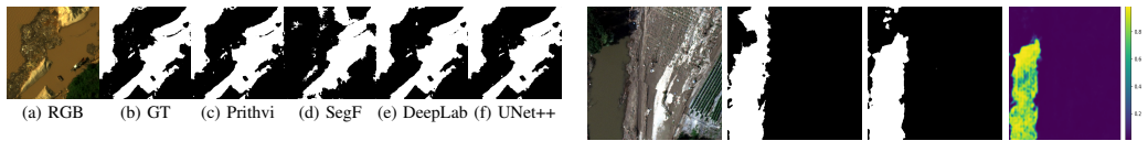
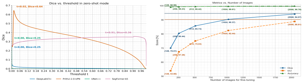
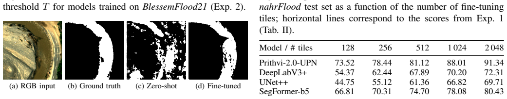
Fine-tuning Prithvi-2.0-UPN on the BlessemFlood21 and NeuenahrFlood RGB datasets produces state-of-the-art binary water segmentation. When trained only on BlessemFlood21, it outperforms baselines on NeuenahrFlood in zero-shot evaluation. With additional fine-tuning on small portions of NeuenahrFlood data, it improves more rapidly than the baselines and approaches the accuracy of full training on that dataset.
What carries the argument
Prithvi-2.0-UPN, formed by attaching a UPerNet decoder to the Prithvi-EO-2.0-600M Vision Transformer for pixel-level water classification after satellite pretraining.
If this is right
- A model trained on one flood event can be applied directly to another event and still produce usable flood maps without new labels.
- Adding only a small fraction of labels from a new event brings the model close to its best possible accuracy faster than competing models.
- Satellite-pretrained models can bridge the gap to centimeter-scale nadir RGB imagery for water segmentation tasks.
- Full training on either dataset alone yields segmentation accuracy at the level of current state-of-the-art methods.
Where Pith is reading between the lines
- Emergency mapping teams could maintain one base model and update it with minimal new labels when a different flood occurs.
- The same adaptation strategy may extend to other rapid-response tasks such as mapping landslides or burned areas from RGB imagery.
- Including more aerial RGB data during pretraining could reduce the amount of fine-tuning needed for future events.
Load-bearing premise
The two chosen flood datasets capture scenery and sensor differences that are representative enough for the transfer results to apply to other real-world flood events.
What would settle it
Running the same zero-shot and few-shot experiments on a third flood dataset with different terrain or imaging conditions and finding that baseline models match or exceed Prithvi-2.0-UPN performance would disprove the claimed transfer advantage.
Figures
read the original abstract
Timely, high-resolution maps of flood extent around settlements are essential for emergency response and damage assessment. We consider airborne RGB imagery for flood mapping as it can be collected rapidly at low cost. To produce flood maps, deep learning models for water segmentation are often used. CNN based and small vision transformer models are used. However, they need much data for adaptation to a change of scenery, i.e., another flooding event. Vision foundation models or large vision transformers are known to generalize across domains. Recently, foundation models for Earth observation became available. They are pretrained on satellite data, whose spatial resolution, viewing geometry, and radiometry differ from nadir RGB imagery. Thus, adaptation is required. We investigate how a satellite-pretrained Earth observation foundation model can be adapted to centimeter-scale floodwater mapping from RGB imagery. Specifically, we fine-tune a model we call Prithvi-2.0-UPN consisting of the Prithvi-EO-2.0-600M Vision Transformer combined with a UPerNet decoder for binary water segmentation on two RGB datasets (BlessemFlood21, NeuenahrFlood). In a first experiment we observe that Prithvi-2.0-UPN reaches state-of-the-art results on BlessemFlood21 and NeuenahrFlood, when trained on their datasets. In a second experiment we show that Prithvi-2.0-UPN performs better than state-of-the-art baseline models for transfer to a new flood event (trained on BlessemFlood21, tested on NeuenahrFlood) in a zero-shot setting. However, the performance indicates room for improvement. In this respect, we investigate in a third experiment how performance improves when further fine-tuning the models with small shares of NeuenahrFlood training data: Prithvi-2.0-UPN improves the fastest and reaches almost the performance level when fully trained on NeuenahrFlood, indicating transfer capabilities.
Editorial analysis
A structured set of objections, weighed in public.
Referee Report
Summary. The manuscript introduces Prithvi-2.0-UPN, formed by combining the Prithvi-EO-2.0-600M vision transformer (pretrained on satellite data) with a UPerNet decoder, and fine-tunes it for binary water segmentation on airborne RGB flood imagery. Experiments on the BlessemFlood21 and NeuenahrFlood datasets show that the model reaches state-of-the-art results when trained on each dataset individually, outperforms baseline models in zero-shot transfer from BlessemFlood21 to NeuenahrFlood, and exhibits the fastest performance gains when further fine-tuned with small fractions of the target-domain training data.
Significance. If the reported transfer results hold under scrutiny, the work provides evidence that satellite-pretrained Earth-observation foundation models can be adapted to centimeter-scale RGB flood mapping with limited target data. This could support faster model deployment for new flood events, though the practical value hinges on whether the observed advantages generalize beyond the two evaluated German datasets.
major comments (2)
- [Datasets and Experimental Setup] Datasets section: both BlessemFlood21 and NeuenahrFlood occurred in western Germany with comparable urban/rural mixes, vegetation, and nadir RGB acquisition geometry. The manuscript provides no quantitative comparison of domain shift (e.g., via image histograms, lighting statistics, or sensor response differences), which is load-bearing for the claim that superior zero-shot and few-shot transfer on this pair demonstrates advantage for arbitrary new flood events.
- [Results] Zero-shot and few-shot results paragraphs: the abstract and results claim state-of-the-art and fastest adaptation, yet the provided summary supplies no numerical metrics, error bars, dataset sizes, or implementation details; without these the magnitude and statistical significance of the reported improvements cannot be verified.
minor comments (2)
- [Abstract] Abstract: states performance improvements and faster adaptation but supplies no quantitative metrics, error bars, or implementation details.
- [Method] Model naming: the term Prithvi-2.0-UPN is introduced without an explicit statement of whether it denotes a novel architectural contribution or simply the combination of the existing Prithvi-EO-2.0-600M backbone with UPerNet.
Simulated Author's Rebuttal
We thank the referee for the constructive feedback, which highlights important aspects of our experimental design and presentation. We address each major comment below and commit to revisions that strengthen the manuscript without altering its core claims.
read point-by-point responses
-
Referee: [Datasets and Experimental Setup] Datasets section: both BlessemFlood21 and NeuenahrFlood occurred in western Germany with comparable urban/rural mixes, vegetation, and nadir RGB acquisition geometry. The manuscript provides no quantitative comparison of domain shift (e.g., via image histograms, lighting statistics, or sensor response differences), which is load-bearing for the claim that superior zero-shot and few-shot transfer on this pair demonstrates advantage for arbitrary new flood events.
Authors: We agree that the similarity in geographic location, land cover, and acquisition geometry between the two datasets represents a limitation for generalizing the transfer results to arbitrary new flood events. In the revised manuscript, we will add a dedicated subsection with quantitative domain-shift analysis, including color histogram comparisons, mean and standard deviation of pixel intensities per channel, and basic lighting statistics derived from the RGB images. This will better contextualize the observed zero-shot and few-shot performance. revision: yes
-
Referee: [Results] Zero-shot and few-shot results paragraphs: the abstract and results claim state-of-the-art and fastest adaptation, yet the provided summary supplies no numerical metrics, error bars, dataset sizes, or implementation details; without these the magnitude and statistical significance of the reported improvements cannot be verified.
Authors: The full manuscript includes tables reporting all numerical metrics (IoU, F1-score, precision, recall) for the in-domain, zero-shot, and few-shot experiments, along with dataset sizes for each split and training hyperparameters. Multiple runs with different random seeds provide standard deviations as error bars. We will revise the abstract to include the key numerical improvements and ensure the results section explicitly references these tables and implementation details for immediate verifiability. revision: yes
Circularity Check
No circularity: purely empirical results on held-out data
full rationale
The paper contains no equations, derivations, or parameter-fitting steps that could reduce to self-definition or fitted-input predictions. All claims rest on direct performance measurements (IoU, etc.) of models trained and evaluated on the two named flood datasets with explicit train/test splits. No self-citation is invoked to justify uniqueness or to close a logical loop; the central transfer results are falsifiable external benchmarks rather than internal redefinitions. This is the normal case of an empirical computer-vision study whose validity hinges on data representativeness, not on any circular reduction.
Axiom & Free-Parameter Ledger
axioms (1)
- domain assumption A satellite-pretrained Earth observation foundation model can be adapted via fine-tuning to centimeter-scale airborne RGB imagery for binary water segmentation.
Reference graph
Works this paper leans on
-
[1]
CRED Crunch Newsletter, Issue No. 74: Disaster Year In Review 2023,
C. for Research on the Epidemiology of Dis- asters, “CRED Crunch Newsletter, Issue No. 74: Disaster Year In Review 2023,” April
2023
-
[2]
Available: https://reliefweb.int/attachments/ 6e641ebe-8d01-4a26-82c4-7819fd968ed6/CredCrunch74.pdf
[Online]. Available: https://reliefweb.int/attachments/ 6e641ebe-8d01-4a26-82c4-7819fd968ed6/CredCrunch74.pdf
-
[3]
Report: Natural catastrophes in 2021: the floodgates are open,
L. Bevere, F. Remondi, N. Aellen, K. Dhore, G. Mussetti, and S. T. et al., “Report: Natural catastrophes in 2021: the floodgates are open,”International Insurance Society, 2022, https://www. segurostv.es/data/informes/Swiss_Re_sigma_report1_2022.pdf
2021
-
[4]
Natural Disasters,
H. Ritchie and M. Roser, “Natural Disasters,”Our World in Data, 2022, https://ourworldindata.org/natural-disasters Updated: 4 January 2024. [Online]. Available: https: //ourworldindata.org/natural-disasters
2022
-
[5]
Arias, N
P. Arias, N. Bellouin, E. Coppola, R. Jones, Krinner, Gerhard, and J. Marotzke et al., “2021: Technical Summary. In Climate Change 2021: The Physical Science Basis. Contribution of Working Group I to the Sixth Assessment Report of the Intergovernmental Panel on Climate Change,” IPPC, United Kingdom and New York, Tech. Rep., 2021, https://www.ipcc.ch/repor...
2021
-
[6]
Ai-based drone assisted human rescue in disaster environments: Challenges and opportunities,
N. Papyan, M. Kulhandjian, H. Kulhandjian, and L. Aslanyan, “Ai-based drone assisted human rescue in disaster environments: Challenges and opportunities,”Pattern Recognition and Image Analysis, vol. 34, no. 1, pp. 169–186, 2024
2024
-
[7]
Applications of drone in disaster management: A scoping review,
S. M. S. M. Daud, M. Y . P. M. Yusof, C. C. Heo, L. S. Khoo, M. K. C. Singh, M. S. Mahmood, and H. Nawawi, “Applications of drone in disaster management: A scoping review,”Science & Justice, vol. 62, no. 1, pp. 30–42, 2022
2022
-
[8]
Evaluation of sugarcane crop growth monitor- ing using vegetation indices derived from rgb-based uav images and machine learning models,
P. Ruwanpathirana, K. Sakai, G. Jayasinghe, T. Nakandakari, K. Yuge, W. Wijekoon, A. Priyankara, M. Samaraweera, and P. Madushanka, “Evaluation of sugarcane crop growth monitor- ing using vegetation indices derived from rgb-based uav images and machine learning models,”Agronomy, vol. 14, no. 9, p. 2059, 2024
2059
-
[9]
Evaluation of an unmanned aerial vehicle (uav) for measuring and monitoring natural disaster risk areas,
M. Reiss, T. Mendes, F. Pereira, M. de Andrade, R. Mendes, S. Simões, R. de Lara, and S. de Souza, “Evaluation of an unmanned aerial vehicle (uav) for measuring and monitoring natural disaster risk areas,”The International Archives of the Photogrammetry, Remote Sensing and Spatial Information Sci- ences, vol. 43, pp. 1077–1083, 2022
2022
-
[10]
Using uav data to improve the situational awareness for first responders in disaster management: The ex- ample of flooding in the ahr valley, germany,
M. Halbgewachs, L. Angermann, M. Wieland, U. Kippnich, and K. Lechner, “Using uav data to improve the situational awareness for first responders in disaster management: The ex- ample of flooding in the ahr valley, germany,” inIGARSS 2023 - 2023 IEEE International Geoscience and Remote Sensing Symposium, 2023, pp. 934–937
2023
-
[11]
Openstreetmap: User-generated street maps,
M. Haklay and P. Weber, “Openstreetmap: User-generated street maps,”IEEE Pervasive computing, vol. 7, no. 4, pp. 12–18, 2008
2008
-
[12]
A river flooding detection system based on deep learning and computer vision,
F. E. Fernandes Jr, L. G. Nonato, and J. Ueyama, “A river flooding detection system based on deep learning and computer vision,”Multimedia Tools and Applications, vol. 81, no. 28, pp. 40 231–40 251, 2022
2022
-
[13]
Urbansarfloods: Sentinel- 1 slc-based benchmark dataset for urban and open-area flood mapping,
J. Zhao, Z. Xiong, and X. X. Zhu, “Urbansarfloods: Sentinel- 1 slc-based benchmark dataset for urban and open-area flood mapping,” inProceedings of the IEEE/CVF Conference on Computer Vision and Pattern Recognition (CVPR) Workshops, June 2024, pp. 419–429
2024
-
[14]
Domain knowledge- aware remote sensing foundation model for flood detection in multi-spectral imagery,
Y . Li, B. Dang, F. Wei, J. Tan, and Y . Lin, “Domain knowledge- aware remote sensing foundation model for flood detection in multi-spectral imagery,” inIGARSS 2024-2024 IEEE Interna- tional Geoscience and Remote Sensing Symposium. IEEE, 2024, pp. 785–789
2024
-
[15]
Overcoming the uncertainty challenges in flood rapid mapping with multi- source optical data,
J. Li, H. Huang, W. He, H. Zhang, and L. Zhang, “Overcoming the uncertainty challenges in flood rapid mapping with multi- source optical data,” inIGARSS 2024-2024 IEEE International Geoscience and Remote Sensing Symposium. IEEE, 2024, pp. 780–784
2024
-
[16]
Fully convolutional network for automatic road extraction from satel- lite imagery,
A. Buslaev, S. Seferbekov, V . Iglovikov, and A. Shvets, “Fully convolutional network for automatic road extraction from satel- lite imagery,” inProceedings of the IEEE conference on com- puter vision and pattern recognition workshops, 2018, pp. 207– 210
2018
-
[17]
Segment anything model for road network graph extraction,
C. Hetang, H. Xue, C. Le, T. Yue, W. Wang, and Y . He, “Segment anything model for road network graph extraction,” in Proceedings of the IEEE/CVF Conference on Computer Vision and Pattern Recognition, 2024, pp. 2556–2566
2024
-
[18]
Stripunet: A method for dense road extraction from remote sensing images,
X. Ma, X. Zhang, D. Zhou, and Z. Chen, “Stripunet: A method for dense road extraction from remote sensing images,”IEEE Transactions on Intelligent Vehicles, 2024
2024
-
[19]
Encoder-decoder with atrous separable convolution for se- mantic image segmentation,
L.-C. Chen, Y . Zhu, G. Papandreou, F. Schroff, and H. Adam, “Encoder-decoder with atrous separable convolution for se- mantic image segmentation,” inProceedings of the European conference on computer vision (ECCV), 2018, pp. 801–818
2018
-
[20]
Unet++: A nested u-net architecture for medical image seg- mentation,
Z. Zhou, M. M. Rahman Siddiquee, N. Tajbakhsh, and J. Liang, “Unet++: A nested u-net architecture for medical image seg- mentation,” inDeep Learning in Medical Image Analysis and Multimodal Learning for Clinical Decision Support: 4th Inter- national Workshop, and 8th International Workshop, Held in Conjunction with MICCAI 2018, Proceedings 4. Springer, 20...
2018
-
[21]
SegFormer: Simple and efficient design for semantic segmentation with transformers,
E. Xie, W. Wang, Z. Yu, A. Anandkumar, J. M. Alvarez, and P. Luo, “SegFormer: Simple and efficient design for semantic segmentation with transformers,”Advances in Neural Informa- tion Processing Systems, vol. 34, pp. 12 077–12 090, 2021
2021
-
[22]
Uavs in disaster management: Application of integrated aerial imagery and convolutional neural network for flood detection,
H. S. Munawar, F. Ullah, S. Qayyum, S. I. Khan, and M. Mojta- hedi, “Uavs in disaster management: Application of integrated aerial imagery and convolutional neural network for flood detection,”Sustainability, vol. 13, no. 14, p. 7547, 2021
2021
-
[23]
Enhanced urban flood monitoring: Integrating advanced semantic segmentation and human facial feature and posture analysis,
B. B. Nair, P. Vallimeena, U. Gopalakrishnan, S. N. Rao, and S. Krishnamoorthy, “Enhanced urban flood monitoring: Integrating advanced semantic segmentation and human facial feature and posture analysis,”IEEE Access, 2024
2024
-
[24]
Spacenet 8-the de- tection of flooded roads and buildings,
R. Hänsch, J. Arndt, D. Lunga, M. Gibb, T. Pedelose, A. Boedi- hardjo, D. Petrie, and T. M. Bacastow, “Spacenet 8-the de- tection of flooded roads and buildings,” inProceedings of the IEEE/CVF Conference on Computer Vision and Pattern Recognition, 2022, pp. 1472–1480
2022
-
[25]
FloodNet: A High Resolution Aerial Imagery Dataset for Post Flood Scene Understanding,
M. Rahnemoonfar, T. Chowdhury, A. Sarkar, D. Varshney, M. Yari, and R. R. Murphy, “FloodNet: A High Resolution Aerial Imagery Dataset for Post Flood Scene Understanding,” IEEE Access, vol. 9, pp. 89 644–89 654, 2021
2021
-
[26]
Post flood damage assessment using aerial imagery,
T. Dixit and P. K. Singh, “Post flood damage assessment using aerial imagery,” in2023 IEEE International Conference on Computer Vision and Machine Intelligence (CVMI). IEEE, 2023, pp. 1–6
2023
-
[27]
Flood vulnerability assessment of urban buildings based on integrating high-resolution remote sensing and street view images,
Z. Xing, S. Yang, X. Zan, X. Dong, Y . Yao, Z. Liu, and X. Zhang, “Flood vulnerability assessment of urban buildings based on integrating high-resolution remote sensing and street view images,”Sustainable Cities and Society, vol. 92, p. 104467, 2023
2023
-
[28]
Road damage detection from post-disaster high-resolution remote sensing im- ages based on tld framework,
K. Zhao, J. Liu, Q. Wang, X. Wu, and J. Tu, “Road damage detection from post-disaster high-resolution remote sensing im- ages based on tld framework,”IEEE Access, vol. 10, pp. 43 552– 43 561, 2022
2022
-
[29]
Blessem- flood21: A high-resolution georeferenced dataset for advanced analysis of river flood scenarios,
V . Polushko, A. Jenal, J. Bongartz, I. Weber, D. Hatic, R. Roesch, T. März, M. Rauhut, and A. Weinmann, “Blessem- flood21: A high-resolution georeferenced dataset for advanced analysis of river flood scenarios,”IEEE Access, 2024
2024
-
[30]
Neuenahrflood dataset and an improved human-in-the-loop strategy for efficient flood water segmen- tation,
V . Polushko, T. Bucher, D. Hatic, R. Rösch, T. März, M. Rauhut, and A. Weinmann, “Neuenahrflood dataset and an improved human-in-the-loop strategy for efficient flood water segmen- tation,” inEarth Resources and Environmental Remote Sens- ing/GIS Applications XVI, vol. 13671. SPIE, 2025, pp. 405– 414
2025
-
[31]
Flooded road detection using deep learning and street map semantics for humanitarian aid support,
V . Polushko, D. Hatic, R. Rösch, T. März, M. Rauhut, and A. Weinmann, “Flooded road detection using deep learning and street map semantics for humanitarian aid support,” 08 2025, pp. 2923–2928
2025
-
[32]
Foundation models for generalist geospatial artificial intelligence,
J. Jakubik, S. Roy, C. Phillips, P. Fraccaro, D. Godwin, B. Zadrozny, D. Szwarcman, C. Gomes, G. Nyirjesy, B. Ed- wardset al., “Foundation models for generalist geospatial artificial intelligence,”arXiv preprint arXiv:2310.18660, 2023
arXiv 2023
-
[33]
Prithvi-eo-2.0: A versatile multi- temporal foundation model for earth observation applications,
D. Szwarcman, S. Roy, P. Fraccaro, Þ. E. Gíslason, B. Blu- menstiel, R. Ghosal, P. H. de Oliveira, J. L. d. S. Almeida, R. Sedona, Y . Kanget al., “Prithvi-eo-2.0: A versatile multi- temporal foundation model for earth observation applications,” arXiv preprint arXiv:2412.02732, 2024
arXiv 2024
-
[34]
Satmae: Pre-training transformers for temporal and multi-spectral satellite imagery,
Y . Cong, S. Khanna, C. Meng, P. Liu, E. Rozi, Y . He, M. Burke, D. Lobell, and S. Ermon, “Satmae: Pre-training transformers for temporal and multi-spectral satellite imagery,”Advances in Neural Information Processing Systems, vol. 35, pp. 197–211, 2022
2022
-
[35]
Geo-bench: Toward foundation models for earth monitoring,
A. Lacoste, N. Lehmann, P. Rodriguez, E. Sherwin, H. Kerner, B. Lütjens, J. Irvin, D. Dao, H. Alemohammad, A. Drouinet al., “Geo-bench: Toward foundation models for earth monitoring,” Advances in Neural Information Processing Systems, vol. 36, pp. 51 080–51 093, 2023
2023
-
[36]
Evaluating and benchmarking foundation models for earth observation and geospatial ai,
N. Dionelis, C. Fibaek, L. Camilleri, A. Luyts, J. Bosmans, and B. L. Saux, “Evaluating and benchmarking foundation models for earth observation and geospatial ai,”arXiv preprint arXiv:2406.18295, 2024
arXiv 2024
-
[37]
When geoscience meets foundation models: Toward a general geoscience artificial intelligence system,
H. Zhang, J.-J. Xu, H.-W. Cui, L. Li, Y . Yang, C.-S. Tang, and N. Boers, “When geoscience meets foundation models: Toward a general geoscience artificial intelligence system,” IEEE geoscience and remote sensing magazine, 2024
2024
-
[38]
As- sessment of a new geoai foundation model for flood inundation mapping,
W. Li, H. Lee, S. Wang, C.-Y . Hsu, and S. T. Arundel, “As- sessment of a new geoai foundation model for flood inundation mapping,” inProceedings of the 6th ACM SIGSPATIAL Inter- national workshop on AI for geographic knowledge discovery, 2023, pp. 102–109
2023
-
[39]
Earth observation foundation models for region-specific flood segmentation,
H. Tamura-Wicks, G. Dawson, A. Taylor, C. Dearden, A. Jones, and P. Fraccaro, “Earth observation foundation models for region-specific flood segmentation,” inInternational Conference on Learning Representations, 2025
2025
-
[40]
U- prithvi: Integrating a foundation model and u-net for enhanced flood inundation mapping,
V . Kostejn, Y . Essus, J. Abrahamson, and R. R. Vatsavai, “U- prithvi: Integrating a foundation model and u-net for enhanced flood inundation mapping,” in13th International Conference on Geographic Information Science (GIScience 2025). Schloss Dagstuhl–Leibniz-Zentrum für Informatik, 2025, pp. 18–1
2025
-
[41]
Rapid adapta- tion of earth observation foundation models for segmentation,
K. P. Selvam, R. Ramos-Pollan, and F. Kalaitzis, “Rapid adapta- tion of earth observation foundation models for segmentation,” arXiv preprint arXiv:2409.09907, 2024
arXiv 2024
-
[42]
Upernet with convnext for semantic segmentation,
R. Wang, H. Jiang, and Y . Li, “Upernet with convnext for semantic segmentation,” in2023 IEEE 3rd International Confer- ence on Electronic Technology, Communication and Information (ICETCI). IEEE, 2023, pp. 764–769
2023
-
[43]
Blessemflood21: Advancing flood analysis with a high-resolution georeferenced dataset for humanitarian aid support,
V . Polushko, A. Jenal, J. Bongartz, I. Weber, D. Hatic, R. Rösch, T. März, M. Rauhut, and A. Weinmann, “Blessemflood21: Advancing flood analysis with a high-resolution georeferenced dataset for humanitarian aid support,” inIEEE International Geoscience and Remote Sensing Symposium (IGARSS), 2024
2024
discussion (0)
Sign in with ORCID, Apple, or X to comment. Anyone can read and Pith papers without signing in.