REVIEW 4 major objections 5 minor 1 cited by
Reconfigurable Intelligent Surface aided Integrated-Navigation-and-Communication in Urban Canyons: A Satellite Selection Approach
T0 review · 4 major / 5 minor · reviewed 2026-08-06 · deepseek-v4-flash
Pith's one-line read The paper claims a single STAR-RIS can restore MEO satellite positioning in urban canyons by contributing one indirect link, and that indoor positioning cannot be achieved with one surface because all indirect measurements reduce to the…
desk verdict Indoor positioning is unobservable under the paper's own equations, and the abstract and body contradict each other; the outdoor urban-canyon idea is plausible but needs a refocused submission. read the letter →
The pith
A machine-rendered reading of the paper's core claim, the machinery that carries it, and where it could break.
The reading
What carries the argument
The key object is the STAR-RIS with two independent phase configurations, one reflection layer for outdoor users and one transmission layer for indoor users, together with the through-RIS pseudo-range equation $\rho_{cv} = r_{\tau,vR} + d_{Ru} + c\Delta t_r$, in which the user position enters only through the scalar distance $d_{Ru}$ to the surface. This equation feeds a least-squares geometry matrix $A$, and PDoP from $(A^TA)^{-1}$ guides the navigation-prioritized selection; the same surface's phase alignment, using the signal alignment technique, carries the communication-prioritized selection.
What would settle it
Simulate the least-squares position estimate for an indoor user with zero direct satellites and any number of satellites routed through one STAR-RIS, using the measurement model of Eq. (28). The matrix A from Eq. (38) will have identical first three columns for every via-RIS measurement, so $A^TA$ is singular; without an added prior or damping the estimated position error diverges. If the paper's finite indoor error is reproduced, it must come from an initialization or regularization step that should be identified in the model.
Extended reading notes
Core claim
The paper establishes, on its own terms, that a single STAR-RIS array mounted on a building can turn a blocked MEO satellite into an additional navigation constraint for a user in an urban canyon. Combined with three directly visible satellites, the indirect measurement yields a solvable four-equation least-squares system for position and clock offset, and the navigation-prioritized algorithm selects the blocked satellite that minimizes position dilution of precision. For communication, the communication-prioritized algorithm selects the satellite with the best aggregated channel gain and achieves higher ergodic rates in the CO-INAC power-allocation regime. The paper also reports that indoor users, who see no direct satellites, suffer positioning errors that depend mainly on the distance to the single STAR-RIS and cannot be reduced below about five meters by adding more satellites through the same surface.
Load-bearing premise
Every via-STAR-RIS pseudo-range contains the user's position only as the scalar distance from the user to the single RIS, so for a user with no direct satellite links all rows of the least-squares geometry matrix are spatially identical; 3D position is unobservable and the reported finite indoor errors rely on initialization or regularization not stated in the model.
Editorial extensions
If this is right
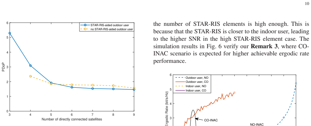
- An outdoor user with three visible satellites can obtain a complete positioning solution when the STAR-RIS adds one indirect satellite link; without the RIS, three satellites are insufficient and PDoP is undefined.
- Navigation-prioritized selection prefers satellites that improve geometric diversity rather than the nearest ones, while communication-prioritized selection prefers the nearest satellite, creating a concrete navigation-communication trade-off.
- Indoor users with zero direct links keep positioning errors dominated by the STAR-RIS-to-user distance even when many satellites are routed through the surface, so a single STAR-RIS cannot deliver indoor 3D positioning.
- CO-INAC mode lets achievable ergodic rate grow with the number of RIS elements and shows a rate ceiling in the high-SNR regime, while NO-INAC supports only low-rate applications.
Reading between the lines
- The rank argument implies that no number of satellites routed through one STAR-RIS can resolve an indoor user's 3D position, since all rows of the geometry matrix share the same spatial direction; fixing this would require multiple STAR-RISs at different locations, fusion with other sensors, or a regularized prior.
- A testable extension is joint satellite-and-surface selection over several distributed STAR-RISs: the paper's PDoP criterion suggests that angular separation between surfaces, not just the number of links, is what improves geometry.
- Because PDoP-based selection ignores received signal strength, a weighted PDoP or a joint rate-and-geometry objective would be a natural next step, since a geometrically favorable satellite may deliver too little power to be usable.
Editorial analysis
A structured set of objections, weighed in public.
Referee Report
Summary. This manuscript studies a STAR-RIS-aided MEO satellite integrated-navigation-and-communication (INAC) network that uses superposition coding and successive interference cancellation. It formulates pseudo-range equations for direct and STAR-RIS-relayed satellite links, computes position dilution of precision (PDoP), and proposes two satellite selection algorithms: NPA, which selects the relayed satellite minimizing PDoP, and CPA, which selects the satellite maximizing an achievable ergodic rate. Numerical results are presented for positioning error and achievable rate for both outdoor urban-canyon users and indoor users. The abstract states that a single STAR-RIS fails to serve indoor users, while the body and figures claim finite indoor positioning errors.
Significance. The topic is timely, and the architectural idea of using a STAR-RIS to create a virtual line-of-sight satellite link in an urban canyon is worth investigating. The paper also deserves credit for explicitly recording in Remark 1 and in the abstract that a single STAR-RIS provides only one virtual link, a limitation that the numerical section does not actually respect. If the stated model were correct, the demonstration that one relayed link plus three direct links suffices for outdoor positioning would be a useful example. However, the central navigation claim fails for the indoor scenario because the measurement model is structurally rank-deficient, and the rate analysis contains a summation error that invalidates the reported rate gains. No code or machine-checked derivations are provided, so all claims rest on the paper's own equations and figures.
major comments (4)
- [III-B, Eqs. (28), (38); V-A; Figs. 2 and 3] The indoor positioning result is contradicted by the paper's own equations. In Eq. (28), every through-RIS pseudo-range has the form r_tau,vR + d_Ru + c*Delta_t_r, where the user position appears only through the scalar distance d_Ru to the single STAR-RIS. Therefore, when several satellites are relayed through the same STAR-RIS, their rows in the geometry matrix A are identical in the spatial partial derivatives and have the same clock coefficient c. For an indoor user with zero direct satellites, as specified in Section V-A, every row of A is identical, so A^T A is singular, Eq. (35) is not invertible, and the PDoP in Eq. (43) is undefined. The finite indoor positioning errors plotted in Figs. 2 and 3 cannot be produced by the stated least-squares model in Eqs. (28)-(40) unless an unstated regularization, initialization, or pseudo-inverse is introduced. This is a structural observability failure, not a parameter-tuning issue: with one STAR-RIS, the relayed links carry only one scalar distance constraint on the user's position. The outdoor urban-canyon case with three direct satellites plus one relayed link may be full-rank and is not called into question by this specific defect, but the paper's headline claim explicitly covers both outdoor and indoor users, and the indoor component is unsupported as written. The manuscript itself concedes this in Remark 1 and in the abstract, yet Section V-A and Fig. 3 treat the indoor case as solvable.
- [IV-B, Eqs. (52)-(53), Figs. 4 and 6] The achievable ergodic rate expressions in Eqs. (52) and (53) are not correct summations over the N STAR-RIS elements. Both expressions sum over n but the summand in Eq. (52) is |beta_1,R g_R,1u h_R,i1 sqrt(L_Riu)| for every term, and Eq. (53) uses |beta_1,T g_T,1u h_R,i1 sqrt(L_Tiu)| for every term. If the index n is not present in the summand, the sum simply multiplies the first element's contribution by N; if the intent was to sum over elements, the summands should be beta_n,R g_R,nu h_R,in and beta_n,T g_T,nu h_R,in. As written, the expressions disregard all STAR-RIS elements except the first, which contradicts the phase-alignment design in Eqs. (48)-(51) and undermines the claims in Figs. 4 and 6 that adding STAR-RIS elements improves the achievable rate and reduces the required transmit power.
- [II-B, Eqs. (11)-(21), Figs. 6 and 7] The labels 'NO-INAC' and 'CO-INAC' appear to be reversed. Eq. (11) defines the NO-INAC case by omega_C > omega_N and states that the user first decodes the communication signal, treating the navigation signal as interference. That decoding order is communication-prioritized, not navigation-prioritized. The CO-INAC case in Section II-B.2 instead imposes omega_C < omega_N and decodes the navigation signal first, which is navigation-prioritized. This swap propagates through Eqs. (12)-(21), Remark 3, and the interpretations of Figs. 6 and 7. Since the power-allocation ordering determines which signal is decoded first under SIC, the reported rate comparisons cannot be interpreted as stated.
- [V-A, Remark 1, contribution list] The manuscript is internally inconsistent about the indoor case. The introduction's contribution list claims the proposed system provides 'revolutionary solutions in the urban canyon and indoor scenarios,' and Section V-A states that the STAR-RIS connects four satellites to the indoor user. However, Remark 1 states that a STAR-RIS array can only provide users with one virtual LoS link, and the abstract states that the single STAR-RIS fails to serve indoor users. These claims cannot all be true simultaneously. The contradiction is not merely editorial: the observability analysis in the first major comment shows that four relayed satellites through one STAR-RIS do not yield four independent positioning equations.
minor comments (5)
- [III-B, Eq. (29)] Eq. (29) defines r_tau,vR using the coordinates (x4, y4, z4), which is the fourth satellite, not the v-th satellite; the subscripts should be consistent with the index v used in Eq. (28).
- [II-A, Eqs. (6)-(7); V, parameter settings] The amplitude coefficient constraints are inconsistent. Eqs. (6)-(7) and the text state beta_n,R^2 + beta_n,T^2 = 1, but the simulations set both beta_n,R and beta_n,T to 0.5, which gives a squared sum of 0.5, a 3 dB energy inconsistency that should be corrected or explicitly justified.
- [Algorithm 1, Section IV-1] Algorithm 1 is not a well-defined pseudocode: it contains placeholder expressions such as 'F(bar_x) = bar_l' and 'x0 approximately = bar_x', and the objective in Eq. (45) uses the positioning error epsilon_u without specifying how it is computed from the measurement model. The algorithm should be replaced with a precise iterative least-squares description.
- [Remarks 2 and 4] Remarks 2 and 4 are presented as findings of the proposed algorithms, but they are essentially direct consequences of the geometry and path-loss expressions: PDoP improves with angular diversity, and the rate in Eqs. (52)-(53) decreases with distance through the large-scale fading factors. They should be stated as observations rather than as algorithm-derived results.
- [Fig. 8] The horizontal axis of Fig. 8 is labeled with numerical values followed by '107', which appears to be a typo for a scientific-notation multiplier; the axis label should be corrected.
Circularity Check
The PDoP-to-position-error relation in Eq. (43) is definitional, making Fig. 2's trend a construction rather than a prediction; the central outdoor positioning derivation remains independent.
-
self definitional
[Section III-C, Eq. (43), and Fig. 2]
"It is clear that the measurement error is amplified by the weight coefficient matrix F and becomes the positioning error. ... PDoP = sqrt(sigma_x^2 + sigma_y^2 + sigma_z^2) = sqrt(h11 + h22 + h33)."
By Eq. (42), Cov([epsilon_x epsilon_y epsilon_z epsilon_t]^T) = (A^T A)^{-1} sigma_URE^2 = F sigma_URE^2, and Eq. (43) defines PDoP as sqrt(h11+h22+h33). Therefore the RMS 3D positioning error equals sigma_URE * PDoP exactly by construction. Fig. 2's observation that positioning error increases with PDoP is not an independent numerical discovery but a restatement of this definitional scaling; the explanation that high PDoP indicates poorer geometry is the same identity. The outdoor full-rank A computation is still an independent geometric calculation, so only the presentation of the PDoP-versus-error curve as a predictive result is circular.
full rationale
The core derivation of the paper is not fitted to data. The pseudorange equations in (27)-(28), the least-squares geometry matrix A in (38), and the PDoP computation in (43) follow the standard satellite-positioning model, and the outdoor urban-canyon claim (three direct satellites plus one STAR-RIS-reflected satellite) is supported by a full-rank geometric construction that is independent of the paper's numerical choices. The STAR-RIS channel model and the NPA/CPA satellite-selection objectives are also stated as explicit models rather than as predictions drawn from the results. The main circular element is the PDoP-to-positioning-error relationship: positioning error is not predicted from PDoP but is, by Eq. (42)-(43), equal to sigma_URE times PDoP, so Fig. 2's monotonic curve is a tautological consequence of the definition. Other flagged aspects of the paper, such as the admitted failure of a single STAR-RIS for indoor scenarios and the rank-deficiency concern for zero-direct-satellite indoor users, are correctness or modeling-consistency issues rather than circularity: they do not reduce a claimed prediction to an input by construction. Self-citations, e.g., the phase-alignment reference [23], concern a standard technique and are not load-bearing in a way that forces the paper's conclusions. Overall, the central outdoor positioning derivation has independent content, but the definitional PDoP-error identity warrants a modest circularity score of 3.
Assumptions & free parameters
free parameters (4)
- Power allocation factors ω_N, ω_C =
ω_C=0.8, ω_N=0.2 (Fig. 6); ω_C=0.65, ω_N=0.35 (Fig. 4)
- Path loss exponents =
2, 2, 2.2 for satellite-RIS, satellite-user, RIS-user links
- Shadowed Rician fading parameters =
b=0.279, m=2, Ω=0.251
- STAR-RIS amplitude coefficients =
β_R=β_T=0.5
assumptions (5)
- domain assumption Pseudo-range measurement errors are independent zero-mean Gaussian with variance σ_URE^2.
- domain assumption Code division lets users separate satellite signals, so a single INAC satellite can represent the communication payload.
- ad hoc to paper Each STAR-RIS-relayed satellite contributes a distinct positioning equation of the form (28).
- domain assumption The STAR-RIS position and satellite positions are known exactly.
- domain assumption Shadowed Rician/Rician small-scale fading models describe the satellite-RIS and RIS-user links.
Cite this review
Pith. "Pith review of Reconfigurable Intelligent Surface aided Integrated-Navigation-and-Communication in Urban Canyons: A Satellite Selection Approach." pith.science (2026). https://pith.science/paper/6ANFBPLS
@misc{pith2026250701766,
  author       = {Pith},
  title        = {Pith review of: Reconfigurable Intelligent Surface aided Integrated-Navigation-and-Communication in Urban Canyons: A Satellite Selection Approach},
  year         = {2026},
  howpublished = {\url{https://pith.science/paper/6ANFBPLS}},
  note         = {Machine review of arXiv:2507.01766}
}
read the original abstract
This study investigates the application of a simultaneous transmitting and reflecting reconfigurable intelligent surface (STAR-RIS)-aided medium-Earth-orbit (MEO) satellite network for providing both global positioning services and communication services in the urban canyons, where the direct satellite-user links are obstructed. Superposition coding (SC) and successive interference cancellation (SIC) techniques are utilized for the integrated navigation and communication (INAC) networks, and the composed navigation and communication signals are reflected or transmitted to ground users or indoor users located in urban canyons. To meet diverse application needs, navigation-oriented (NO)-INAC and communication-oriented (CO)-INAC have been developed, each tailored according to distinct power allocation factors. We then proposed two algorithms, namely navigation-prioritized-algorithm (NPA) and communication-prioritized-algorithm (CPA), to improve the navigation or communication performance by selecting the satellite with the optimized position dilution of precision (PDoP) or with the best channel gain. The effectiveness of the proposed STAR-RIS-aided INAC network is quantified by analyzing the positioning error for navigation services and by evaluating communication performance through achievable ergodic rate metrics. Our satellite selection approach indicates that: the positioning services at the urban canyon users can be completed with the aid of STAR-RIS. 2) Additionally, it is observed that while a single STAR-RIS array can extend the navigational link, it fails to serve users in indoor scenarios, highlighting a limitation in the current system design.
Figures


Figures from the paper (4 more)



Forward citations
Cited by 1 Pith paper
-
Rethinking Satellite Networks: When Navigation Meets Communications
The paper reviews fundamental principles of satellite navigation, communication, and integrated systems, emphasizing 6G integration and conceptual transitions for improved functionality.
Reference graph
Works this paper leans on
-
[1]
Liability for GNSS signals and services,
N. Can, “Liability for GNSS signals and services,” in 2017 8th Interna- tional Conference on Recent Advances in Space Technologies (RAST), Jun. 2017, pp. 529–533
work page 2017
-
[2]
Infi eld Agricul- ture GNSS Assessment Showing EGNOS Benefits,
J. Bruzual, E. Lacarra, C. Post, and J. R. Gonz´ alez, “Infi eld Agricul- ture GNSS Assessment Showing EGNOS Benefits,” in 2020 European Navigation Conference (ENC) , 2020, pp. 1–10
work page 2020
-
[3]
Repeatability test method of GNSS for safe train localisat ion in real and simulated environments,
D. Lu, D. Spiegel, U. Becker, B. Cai, J. Wang, J. Liu, and X. Liu, “Repeatability test method of GNSS for safe train localisat ion in real and simulated environments,” in 2016 IEEE/ION Position, Location and Navigation Symposium (PLANS) , 2016, pp. 687–692
work page 2016
-
[4]
Backpack VLBI terminal with subcentimeter capability,
C. Counselman et al. , “Backpack VLBI terminal with subcentimeter capability,” NASA. Goddard Space Flight Center Radio Interferometry , no. 3, pp. 409–414, Jun. 1980
work page 1980
-
[5]
6G Wireless Communicati ons: Future Technologies and Research Challenges,
S. Elmeadawy and R. M. Shubair, “6G Wireless Communicati ons: Future Technologies and Research Challenges,” in 2019 International Conference on Electrical and Computing Technologies and Ap plications (ICECTA), 2019, pp. 1–5
work page 2019
-
[6]
G. Seco-Granados, J. L ´ opez-Salcedo, D. Jim´ enez-Ba˜ nos, and G. L ´ opez- Risue˜ no, “Challenges in Indoor Global Navigation Satelli te Systems: Unveiling its core features in signal processing,” IEEE Signal Processing Magazine, vol. 29, no. 2, pp. 108–131, Mar. 2012
work page 2012
-
[7]
Land Mobile Satellite Navigation-C haracteristics of the Multipath Channel,
A. L. A. Steingass, “Land Mobile Satellite Navigation-C haracteristics of the Multipath Channel,” in Proceedings of the 16th International Techni- cal Meeting of the Satellite Division of The Institute of Nav igation(ION GPS/GNSS 2003) , Portland, OR, Sept. 2003, pp. 1016–1022
work page 2003
-
[8]
E. Elezi, G. C ¸ ankaya, A. Boyacı, and S. Y arkan, “A detect ion and identification method based on signal power for different ty pes of Electronic Jamming attacks on GPS signals,” in 2019 IEEE 30th Annual International Symposium on Personal, Indoor and Mob ile Radio Communications (PIMRC) , 2019, pp. 1–5
work page 2019
Show all 41 references
-
[9]
INS-assisted high sensitivity GPS receivers for degraded signalnavigation
L. G. Gao GJ and Navstar, “INS-assisted high sensitivity GPS receivers for degraded signalnavigation.” Proceedings of the 19th International Technical Meeting of the Satellite Division of the Institut e of Navigation , 2006
2006
-
[10]
Navigation of vehicle in u rban canyon via two-satellite GNSS and map aiding,
R. S. Kulikov and A. I. Perov, “Navigation of vehicle in u rban canyon via two-satellite GNSS and map aiding,” in 2017 Dynamics of Systems, Mechanisms and Machines (Dynamics) , 2017, pp. 1–7
2017
-
[11]
Enhance d detection performance of indoor GNSS signals based on synthetic apert ure,
A. Broumandan, J. Nielsen, and G. Lachapelle, “Enhance d detection performance of indoor GNSS signals based on synthetic apert ure,” IEEE Trans. V eh. Tech., vol. 59, no. 6, pp. 2711–2724, Jul. 2010
2010
-
[12]
New modified urban canyon models for satellite signal propagation prediction,
H. Hadidianmoghadam and A. B. Kouki, “New modified urban canyon models for satellite signal propagation prediction,” IEEE Access, vol. 7, pp. 25298–25307, 2019
2019
-
[13]
Positioning perf ormance of LEO mega constellations in deep urban canyon environment s,
H. More, E. Cianca, and M. De Sanctis, “Positioning perf ormance of LEO mega constellations in deep urban canyon environment s,” in 2022 25th International Symposium on Wireless Personal Mul timedia Communications (WPMC) , 2022, pp. 256–260
2022
-
[14]
Reconfigurable Intelligent Surfaces for Wireless Communica- tions: Principles, Challenges, and Opportunities,
M. A. ElMossallamy, H. Zhang, L. Song, K. G. Seddik, Z. Ha n, and G. Y . Li, “Reconfigurable Intelligent Surfaces for Wireless Communica- tions: Principles, Challenges, and Opportunities,” IEEE Transactions on Cognitive Communications and Networking , vol. 6, no. 3, pp. 990–100...
2020
-
[15]
A New Wireless Communication Paradigm thr ough Software-Controlled Metasurfaces,
C. Liaskos, S. Nie, A. Tsioliaridou, A. Pitsillides, S. Ioannidis, and I. Akyildiz, “A New Wireless Communication Paradigm thr ough Software-Controlled Metasurfaces,” IEEE Communications Magazine , vol. 56, no. 9, pp. 162–169, Sept. 2018
2018
-
[16]
IRS-Enhanced Wid eband MU-MISO-OFDM Communication Systems,
H. Li, R. Liu, M. Liy, Q. Liu, and X. Li, “IRS-Enhanced Wid eband MU-MISO-OFDM Communication Systems,” in 2020 IEEE Wireless Communications and Networking Conference (WCNC) , 2020, pp. 1–6
2020
-
[17]
Intelligen t Reflecting Surface Enhanced Wideband MIMO-OFDM Communications: From Practical Model to Reflection Optimization,
H. Li, W. Cai, Y . Liu, M. Li, Q. Liu, and Q. Wu, “Intelligen t Reflecting Surface Enhanced Wideband MIMO-OFDM Communications: From Practical Model to Reflection Optimization,” IEEE Transactions on Communications, vol. 69, no. 7, pp. 4807–4820, Jul. 2021
2021
-
[18]
Weighted Sum-Rate Ma xi- mization for Multi-IRS Aided Cooperative Transmission,
Z. Li, M. Hua, Q. Wang, and Q. Song, “Weighted Sum-Rate Ma xi- mization for Multi-IRS Aided Cooperative Transmission,” IEEE Wireless Communications Letters , vol. 9, no. 10, pp. 1620–1624, Oct. 2020
2020
-
[19]
Intelligent R eflecting Surface Meets OFDM: Protocol Design and Rate Maximization,
Y . Y ang, B. Zheng, S. Zhang, and R. Zhang, “Intelligent R eflecting Surface Meets OFDM: Protocol Design and Rate Maximization, ” IEEE Transactions on Communications , vol. 68, no. 7, pp. 4522–4535, Jul. 2020
2020
-
[20]
Achievabl e Rate Max- imization by Passive Intelligent Mirrors,
C. Huang, A. Zappone, M. Debbah, and C. Y uen, “Achievabl e Rate Max- imization by Passive Intelligent Mirrors,” in 2018 IEEE International Conference on Acoustics, Speech and Signal Processing (ICA SSP), 2018, pp. 3714–3718
2018
-
[21]
Intelligent Reflecting Surface V ersus Decode-and-Forward: How Large Surfaces are Needed to Beat Relaying?
E. Bj¨ ornson, o. ¨Ozdogan, and E. G. Larsson, “Intelligent Reflecting Surface V ersus Decode-and-Forward: How Large Surfaces are Needed to Beat Relaying?” IEEE Wireless Communications Letters, vol. 9, no. 2, pp. 244–248, Feb. 2020
2020
-
[22]
Reconfigurable Intelligent Surfaces: Principles and Opportu- nities,
Y . Liu, X. Liu, X. Mu, T. Hou, J. Xu, M. Di Renzo, and N. Al- Dhahir, “Reconfigurable Intelligent Surfaces: Principles and Opportu- nities,” IEEE Communications Surveys Tutorials , vol. 23, no. 3, pp. 1546–1577, thirdquarter 2021
2021
-
[23]
Rec onfigurable Intelligent Surface Aided NOMA Networks,
T. Hou, Y . Liu, Z. Song, X. Sun, Y . Chen, and L. Hanzo, “Rec onfigurable Intelligent Surface Aided NOMA Networks,” IEEE Journal on Selected Areas in Communications , vol. 38, no. 11, pp. 2575–2588, Nov. 2020
2020
-
[24]
The Impact of 5G Channel Models on t he Per- formance of Intelligent Reflecting Surfaces and Decode-and -Forward Relaying,
I. Chatzigeorgiou, “The Impact of 5G Channel Models on t he Per- formance of Intelligent Reflecting Surfaces and Decode-and -Forward Relaying,” in 2020 IEEE 31st Annual International Symposium on Personal, Indoor and Mobile Radio Communications , 2020, pp. 1–4
2020
-
[25]
Hyb rid Beamforming for Reconfigurable Intelligent Surface based M ulti-User Communications: Achievable Rates With Limited Discrete Phase Shifts,
B. Di, H. Zhang, L. Song, Y . Li, Z. Han, and H. V . Poor, “Hyb rid Beamforming for Reconfigurable Intelligent Surface based M ulti-User Communications: Achievable Rates With Limited Discrete Phase Shifts,” IEEE Journal on Selected Areas in Communications , vol. 38, no. 8, pp. ...
2020
-
[26]
Global navigation satellite system (GNSS): A reconfigurable intelligent surf ace (RIS)-aided approach,
Q. Zhao, W. Gong, T. Hou, X. Sun, and E. Bodanese, “Global navigation satellite system (GNSS): A reconfigurable intelligent surf ace (RIS)-aided approach,” in GLOBECOM 2022 - 2022 IEEE Global Communications Conference, 2022, pp. 3162–3167. 12
2022
-
[27]
Deep reinforcement lear ning based joint 3D navigation and phase shift control for mobile inter net of vehicles assisted by RIS-equipped UA Vs,
M. Eskandari and A. V . Savkin, “Deep reinforcement lear ning based joint 3D navigation and phase shift control for mobile inter net of vehicles assisted by RIS-equipped UA Vs,” IEEE Internet of Things Journal , pp. 1–1, 2023
2023
-
[28]
Consensus-based autonomous navigation of a team of RIS-equipped UA Vs for LoS wireless co mmu- nication with mobile nodes in high-density areas,
M. Eskandari, A. V . Savkin, and W. Ni, “Consensus-based autonomous navigation of a team of RIS-equipped UA Vs for LoS wireless co mmu- nication with mobile nodes in high-density areas,” IEEE Transactions on Automation Science and Engineering , vol. 20, no. 2, pp. 923–935, 2023
2023
-
[29]
STAR: simultaneous transmission and reflection for 360° co verage by intelligent surfaces,
Y . Liu, X. Mu, J. Xu, R. Schober, Y . Hao, H. V . Poor, and L. H anzo, “STAR: simultaneous transmission and reflection for 360° co verage by intelligent surfaces,” IEEE Wireless Commun. , vol. 28, no. 6, pp. 102– 109, Dec. 2021
2021
-
[30]
STAR-RISs: Simulta neous transmitting and reflecting reconfigurable intelligent sur faces,
J. Xu, Y . Liu, X. Mu, and O. A. Dobre, “STAR-RISs: Simulta neous transmitting and reflecting reconfigurable intelligent sur faces,” IEEE Commun. Lett. , vol. 25, no. 9, pp. 3134–3138, Sep. 2021
2021
-
[31]
Simultaneo usly transmitting and reflecting (STAR) RIS aided wireless commu nications,
X. Mu, Y . Liu, L. Guo, J. Lin, and R. Schober, “Simultaneo usly transmitting and reflecting (STAR) RIS aided wireless commu nications,” IEEE Trans. Wireless Commun. , vol. 21, no. 5, pp. 3083–3098, May 2022
2022
-
[32]
Simultaneously tran smitting and reflecting (STAR)-RISs: Are they applicable to dual-sided i ncidence?
J. Xu, X. Mu, J. T. Zhou, and Y . Liu, “Simultaneously tran smitting and reflecting (STAR)-RISs: Are they applicable to dual-sided i ncidence?” IEEE Wireless Commun. Lett. , vol. 12, no. 1, pp. 129–133, Nov. 2023
2023
-
[33]
Wireless networks based on high-altitude platforms for the provisio n of integrated navigation/communication services,
D. Avagnina, F. Dovis, A. Ghiglione, and P . Mulassano, “ Wireless networks based on high-altitude platforms for the provisio n of integrated navigation/communication services,” IEEE Communications Magazine , vol. 40, no. 2, pp. 119–125, Feb. 2002
2002
-
[34]
Integrated Wireless Sensor Sy stems via Near-Space and Satellite Platforms: A Review,
W.-Q. Wang and D. Jiang, “Integrated Wireless Sensor Sy stems via Near-Space and Satellite Platforms: A Review,” IEEE Sensors Journal , vol. 14, no. 11, pp. 3903–3914, Nov. 2014
2014
-
[35]
A GNSS/5G Integrated Positio ning Methodology in D2D Communication Networks,
L. Yin, Q. Ni, and Z. Deng, “A GNSS/5G Integrated Positio ning Methodology in D2D Communication Networks,” IEEE Journal on Selected Areas in Communications , vol. 36, no. 2, pp. 351–362, Feb. 2018
2018
-
[36]
Relay-based positioning in TDMA networks,
K. Lee, H. Baek, and J. Lim, “Relay-based positioning in TDMA networks,” IEEE Systems Journal , vol. 12, no. 4, pp. 3849–3852, Dec. 2018
2018
-
[37]
Investigation on Evolving Single-Carrier NOMA Into Multi -Carrier NOMA in 5G,
J. Zeng, T. Lv, R. P . Liu, X. Su, M. Peng, C. Wang, and J. Mei , “Investigation on Evolving Single-Carrier NOMA Into Multi -Carrier NOMA in 5G,” IEEE Access , vol. 6, pp. 48268–48288, 2018
2018
-
[38]
Application of Non-Orthogonal Multiple Access in LT E and 5G Networks,
Z. Ding, Y . Liu, J. Choi, Q. Sun, M. Elkashlan, I. Chih-Li n, and H. V . Poor, “Application of Non-Orthogonal Multiple Access in LT E and 5G Networks,” IEEE Communications Magazine , vol. 55, no. 2, pp. 185– 191, Feb. 2017
2017
-
[39]
Impact of User Pairing on 5G Nonorthogonal Multiple-Access Downlink Transmissions,
Z. Ding, P . Fan, and H. V . Poor, “Impact of User Pairing on 5G Nonorthogonal Multiple-Access Downlink Transmissions,” IEEE Trans- actions on V ehicular Technology , vol. 65, no. 8, pp. 6010–6023, Aug. 2016
2016
-
[40]
Requirements And Technologies Towards Uam: Comm unica- tion, Navigation, And Surveillance,
M. Cenk Ert¨ urk, N. Hosseini, H. Jamal, A. S ¸ ahin, D. Mat olak, and J. Haque, “Requirements And Technologies Towards Uam: Comm unica- tion, Navigation, And Surveillance,” in 2020 Integrated Communications Navigation and Surveillance Conference (ICNS) , 2020, pp. 2C2–1–2C2– 15
2020
-
[41]
Performance analysis of NOMA-RIS aide d integrated navigation and communication (INAC) networks,
T. Hou and A. Li, “Performance analysis of NOMA-RIS aide d integrated navigation and communication (INAC) networks,” IEEE Trans. V eh. Tech., pp. 1–14, 2023
2023
Reviewed August 6, 2026 · model on record in the stance chip above.
Discussion (0). Sign in to comment.