REVIEW 3 major objections 3 minor 35 references
FlexCloud: Direct, Modular Georeferencing and Drift-Correction of Point Cloud Maps
T0 review · 3 major / 3 minor · reviewed 2026-08-09 · deepseek-v4-flash
Pith's one-line read SLAM point clouds georeferenced to 8 cm via rubber-sheet warping
desk verdict A clean, honest pipeline paper whose headline accuracy metric mostly measures the fit to the very GNSS data used to build the transformation; the real gap is no independent ground truth off the trajectory. read the letter →
The pith
A machine-rendered reading of the paper's core claim, the machinery that carries it, and where it could break.
The reading
What carries the argument
The load-bearing object is the 3D rubber-sheet transformation: a piecewise-linear map built from tetrahedra whose vertices are control points on the vehicle trajectory. Each tetrahedron $j$ gets a transformation matrix $T_j$ by solving the linear system $p_{g,i} = T_j p_{o,i}$ at its four corners, where $p_{o,i}$ are odometry positions and $p_{g,i}$ are their GNSS-interpolated counterparts; any point $x$ in the map is then sent to $x' = T_j x$ through whichever tetrahedron contains it. The tetrahedra come from a Delaunay triangulation of the control points, which guarantees a unique, angle-optimal mesh, and an enclosing cuboid anchors the deformation so that the map remains well-defined outside the path. This construction is what lets the method correct spatially varying drift while keeping the map continuous.
What would settle it
Collect a LiDAR/GNSS dataset on a site with surveyed ground-truth features (e.g., building corners or reflectors) located tens of meters from the vehicle path, run FlexCloud, and compare the georeferenced positions of those off-path features to their surveyed coordinates. If the off-path error grows with distance from the trajectory far beyond the 0.08 m trajectory error, the extrapolation assumption fails.
Extended reading notes
Core claim
The central discovery is that a trajectory-based rubber-sheet transformation, extended to three dimensions and fed by automatically selected GNSS-derived control points, can simultaneously georeference a SLAM point cloud map and absorb the spatially varying drift of the odometry. The paper shows that control points need not be surveyed or manually matched: they are generated by B-spline interpolation of the RTK-GNSS trajectory at the timestamps of odometry keyframes, then filtered by the reported GNSS standard deviation. A Delaunay tetrahedralization of these control points defines a piecewise-linear transformation that is applied to every point in the map, preserving continuity while correcting local distortions. The reported result is that the corrected trajectory follows the GNSS trajectory to sub-decimeter mean absolute error on well-conditioned data, with qualitative satellite-imagery checks indicating the map itself also aligns.
Load-bearing premise
The load-bearing premise is that the distortion measured along the vehicle's driven path also describes the distortion of map points lying far from that path, such as building facades and off-road terrain; the quantitative test only checks the trajectory itself, not those off-path points.
Editorial extensions
If this is right
- Georeferencing no longer requires surveyed control points: a mobile mapping vehicle with an RTK-GNSS receiver and any LiDAR SLAM front-end can produce globally referenced point cloud maps.
- When GNSS accuracy is good, the corrected map can reach the 10-20 cm accuracy expected of HD maps, because the point cloud inherits the accuracy of the GNSS trajectory.
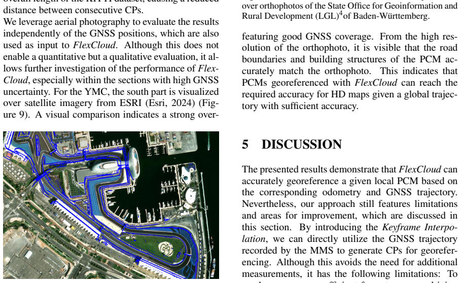
- Sections of the trajectory with unreliable GNSS can still be georeferenced, because interpolation and the enclosing tetrahedra carry the transformation across gaps; the paper shows such a section at YMC where the map still matches satellite imagery.
- The approach is modular: only the odometry trajectory and local map are consumed, so it can be dropped into different SLAM stacks without modifying them.
- Increasing the number of control points reduces the trajectory error monotonically in the tested ranges, from 1.71 m with 10 control points to 0.08 m with 200 control points at YMC.
Reading between the lines
- An extension the paper leaves implicit: the same trajectory-based rubber-sheet idea could be applied to aerial or handheld mapping, anywhere an odometry path plus absolute positioning is available, with the same caution about off-path extrapolation.
- Because GNSS standard deviation is used only as a hard threshold, a natural testable improvement is to weight control points by their inverse variance and allow the transformation to relax in low-confidence regions; the poor-GNSS section of KITTI would isolate whether that helps.
- The paper's quantitative proof is about trajectory alignment, so the claim that the whole map is accurately georeferenced currently rests on the satellite-overlay check; a stronger test would use surveyed off-path checkpoints to reveal how fast the deformation field degrades away from the road.
- The cuboid boundary shape is a likely source of residual deformation near map edges; replacing it with a polygon hull or adding far-field anchors could remove boundary artifacts for large maps.
Editorial analysis
A structured set of objections, weighed in public.
Referee Report
Summary. The paper presents FlexCloud, a modular pipeline for georeferencing and drift-correcting local point cloud maps (PCMs) generated by SLAM. The pipeline takes as input a local PCM, its odometry trajectory, and a GNSS trajectory; it interpolates GNSS positions at odometry keyframes, performs a rigid alignment via Umeyama's method, and then applies a 3D piecewise-linear rubber-sheet transformation built from control points on the trajectory. The method is evaluated on the Yas Marina Circuit dataset and KITTI sequence 00, reporting a mean absolute error between the transformed odometry trajectory and the interpolated GNSS trajectory of 0.08 m with 200 control points for the Yas Marina Circuit and 0.47 m for KITTI sequence 00. The paper also provides qualitative satellite-image overlays and makes the source code publicly available.
Significance. If the claimed accuracy extended to the full point cloud, FlexCloud would be a practically useful, modular contribution to HD-map generation, and the open-source ROS 2 implementation is a valuable asset for reproducibility. The interpolation-based automatic control-point selection and the 3D extension of rubber-sheeting are reasonable engineering ideas. However, the current evidence supports only that the transformed odometry trajectory closely tracks the GNSS trajectory at the control points; the paper does not provide an independent quantitative validation of the georeferencing accuracy of the actual point cloud, especially away from the vehicle trajectory. The significance of the central claim therefore remains unsubstantiated until such validation is added.
major comments (3)
- [Section 4, Equations (4)-(5)] The primary quantitative metric is circular. The evaluation computes the Euclidean deviation between the transformed odometry trajectory and the interpolated GNSS trajectory, but the same interpolated GNSS trajectory supplies the control points pg,i in Equation (4). Because Equation (4) is solved so that each odometry control point maps exactly to its GNSS control point, the error at every control point is zero by construction. The reported MAE of 0.08 m therefore measures piecewise-linear interpolation error between control points along the trajectory, not the georeferencing accuracy of the point cloud map. An independent ground-truth reference is needed to support the paper's accuracy claims.
- [Section 3.3, Equation (5)] The rubber-sheet deformation is inferred from control points lying on the vehicle trajectory (plus the eight enclosing-cuboid corners) and then applied to every point in the PCM via Equation (5). This assumes that the deformation field estimated along a one-dimensional path extrapolates correctly to the surrounding three-dimensional volume, including off-road areas and vertical structures. The paper does not validate this assumption. Moreover, the mapping of the enclosing-cuboid corners from the odometry frame to the global frame is never specified; for points outside the convex hull of the trajectory control points, the transformation depends entirely on this unspecified mapping, so the extrapolation is not well-defined as presented. The cuboid-corner correspondence should be stated explicitly, and off-trajectory accuracy should be validated with independent features (e.g., surveyed reflectors or building corners).
- [Section 5 and Figures 9-10] The qualitative satellite overlays do not substantiate the statement in Section 5 that 'FlexCloud can accurately georeference a given local PCM.' Figures 9 and 10 are not metric evaluations and cover only small excerpts of the maps; visual overlap can be misleading at the decimeter level claimed for HD maps. The KITTI result is likewise not compared with any external reference. A quantitative evaluation against an independent data source (e.g., surveyed control points, aerial orthophoto alignment error, or loop-closure constraints that were not used in the transformation) is required to support the central claim.
minor comments (3)
- [Section 3, paragraph on implementation] The text says the pipeline is implemented as a 'standalone ROS 23 package'; this appears to be a typo for 'ROS 2 package' (the footnote marker for the ROS reference seems to have been lost). Please correct.
- [Figure 6 caption] The caption 'using ncp = 10 CP on the YMC' should be written as 'using n_cp = 10 control points'; please also state the numerical values of the enclosing-cuboid offset parameters in the caption or in the main text, since these are user-configurable and affect the transformation outside the trajectory.
- [Section 4, KITTI discussion] The claim that the larger KITTI MAE 'follows from an overall worse quality of the GNSS positions' is plausible but not quantified; reporting the GNSS standard deviations along the trajectory would make this statement verifiable.
Circularity Check
The 0.08 m Yas Marina accuracy is the interpolation residual of a rubber-sheet fit computed from the same GNSS trajectory used as the evaluation target, so it does not independently validate georeferencing of the point cloud map.
-
fitted input called prediction
[Section 3.3 (Rubber-Sheet Transformation), Eq. (4)-(5); Section 4 (Results), quantitative evaluation]
"The input parameters for the Rubber-Sheet Transformation are the interpolated, global trajectory and the rigidly aligned odometry trajectory. CPs are automatically selected ... pg,i = Tj po,i i ∈ {k,l,m,q} ... Finally, the odometry trajectory and the PCM are transformed ... x′ = Tj x (5) ... In contrast to the Rubber-Sheet transformation, which only uses selected CPs, the evaluation is conducted on all trajectory points without excluding points with high standard deviation."
Equation (4) solves each tetrahedron's affine transformation T_j from the four control-point correspondences between the odometry and GNSS trajectories, so the selected odometry CPs are mapped exactly onto the GNSS CPs by construction. Section 4 then computes the deviation of the transformed odometry trajectory to the interpolated GNSS trajectory on all trajectory points, which is the same GNSS data from which the CPs were drawn. The reported MAE (0.08 m with 200 CPs at YMC) is thus a piecewise-linear interpolation error of a function whose values at the CPs are prescribed, not an independent georeferencing error, and it decreases as ncp increases for that reason. Applying the same T_j to all PCM points via Eq.
full rationale
The rubber-sheet method itself is a legitimate conflation technique: CPs are selected automatically, a Delaunay triangulation is built, and each tetrahedron receives an affine map from trajectory correspondences. This is not circular in the sense of being defined in terms of the output. The circularity is confined to the quantitative evaluation. The only metric in Section 4 is the deviation of the deformed odometry trajectory from the interpolated GNSS trajectory, and that GNSS trajectory is the source of the CPs used to fit Eq. (4); at the CPs the fit is exact by construction, so the reported 0.08 m MAE is essentially interpolation error along the path. The satellite and orthophoto overlays in Figures 9-10 are an independent external check, but they are qualitative and cover small map excerpts, so they cannot rescue the headline numeric claim as a map-accuracy measurement. The extrapolation of trajectory-fitted deformations to off-trajectory map points via Eq. (5) is a real correctness and validation gap, but it is not itself circularity; it is flagged here only as the reason the central PCM accuracy claim remains unsubstantiated by independent data. No load-bearing self-citation was found: the prior FlexMap Fusion paper is cited for the earlier 2D version, while the rubber-sheet concept is attributed to standard cartography references, so the score is 6 rather than higher.
Assumptions & free parameters
free parameters (4)
- Number of control points n_cp =
YMC: 200 (sweep 10/50/100/200); KITTI: 150 (sweep 10/50/150)
- GNSS standard deviation threshold for CP selection =
0.05 m (YMC), 0.25 m (KITTI)
- Minimum spatial distance threshold between GNSS frames for interpolation =
Not specified numerically
- Enclosing cuboid offset =
0.1 times x/y extent, 10 times z extent
assumptions (5)
- domain assumption The GNSS trajectory is an accurate global reference for both construction and evaluation of the transformation.
- ad hoc to paper The deformation of the entire point cloud can be modeled by a piecewise-linear rubber-sheet transformation defined from control points on the trajectory.
- domain assumption Time synchronization between GNSS and LiDAR is correct.
- standard math Umeyama's least-squares method gives the optimal rigid alignment.
- standard math Delaunay triangulation is unique and angle-optimal for a given point set.
Cite this review
Pith. "Pith review of FlexCloud: Direct, Modular Georeferencing and Drift-Correction of Point Cloud Maps." pith.science (2026). https://pith.science/paper/CGY25524
@misc{pith2026250200395,
  author       = {Pith},
  title        = {Pith review of: FlexCloud: Direct, Modular Georeferencing and Drift-Correction of Point Cloud Maps},
  year         = {2026},
  howpublished = {\url{https://pith.science/paper/CGY25524}},
  note         = {Machine review of arXiv:2502.00395}
}
read the original abstract
Current software stacks for real-world applications of autonomous driving leverage map information to ensure reliable localization, path planning, and motion prediction. An important field of research is the generation of point cloud maps, referring to the topic of simultaneous localization and mapping (SLAM). As most recent developments do not include global position data, the resulting point cloud maps suffer from internal distortion and missing georeferencing, preventing their use for map-based localization approaches. Therefore, we propose FlexCloud for an automatic georeferencing of point cloud maps created from SLAM. Our approach is designed to work modularly with different SLAM methods, utilizing only the generated local point cloud map and its odometry. Using the corresponding GNSS positions enables direct georeferencing without additional control points. By leveraging a 3D rubber-sheet transformation, we can correct distortions within the map caused by long-term drift while maintaining its structure. Our approach enables the creation of consistent, globally referenced point cloud maps from data collected by a mobile mapping system (MMS). The source code of our work is available at https://github.com/TUMFTM/FlexCloud.
Figures


Figures from the paper (6 more)


Reference graph
Works this paper leans on
-
[1]
Bao, Z., Hossain, S., Lang, H., and Lin, X. (2022). High- Definition Map Generation Technologies For Autonomous Driving . ArXiv , abs/2206.05400
arXiv 2022
-
[2]
Bao, Z., Hossain, S., Lang, H., and Lin, X. (2023). A review of high-definition map creation methods for autonomous driving. Engineering Applications of Artificial Intelligence , 122:106125
work page 2023
-
[3]
Chen, X., Milioto, A., Palazzolo, E., Giguere, P., Behley, J., and Stachniss, C. (2019). SuMa ++: Efficient LiDAR -based Semantic SLAM . In 2019 IEEE / RSJ International Conference on Intelligent Robots and Systems ( IROS ) . IEEE
work page 2019
-
[4]
Esri (2024). Arcgis world imagery. Available at: https://www.arcgis.com/apps/mapviewer/index.html?layers=10df2279f9684e4a9f6a7f08febac2a9 (accessed on 2024-11-29)
work page 2024
-
[5]
Geiger, A., Lenz, P., Stiller, C., and Urtasun, R. (2013). Vision meets robotics: The KITTI dataset. The International Journal of Robotics Research , 32(11):1231--1237. \_eprint: https://doi.org/10.1177/0278364913491297
-
[6]
Geiger, A., Lenz, P., and Urtasun, R. (2012). Are we ready for autonomous driving? The KITTI vision benchmark suite. In 2012 IEEE Conference on Computer Vision and Pattern Recognition , pages 3354--3361
work page 2012
-
[7]
Gillman, D. (1985). Triangulations for rubber-sheeting. In Proceedings of 7th International symposium on computer assisted cartography (AutoCarto 7) , volume 199
work page 1985
-
[8]
Groves, P. (2013). Principles of GNSS , Inertial , and Multisensor Integrated Navigation Systems , Second Edition . Artech
work page 2013
Show all 35 references
-
[9]
Hariz, F., Souifi, H., Leblanc, R., Bouslimani, Y., Ghribi, M., Langin, E., and Mccarthy, D. (2021). Direct Georeferencing 3D Points Cloud Map Based on SLAM and Robot Operating System . In 2021 IEEE International Symposium on Robotic and Sensors Environments ( ROSE ) , pages 1--6
2021
-
[10]
Hess, W., Kohler, D., Rapp, H., and Andor, D. (2016). Real-time loop closure in 2d lidar slam. In 2016 IEEE International Conference on Robotics and Automation (ICRA) , pages 1271--1278
2016
-
[11]
Jamin, C., Pion, S., and Teillaud, M. (2024). 3D triangulations. In CGAL User and Reference Manual . CGAL Editorial Board , 6.0.1 edition
2024
-
[12]
Y., Lee, H., Darweesh, H., and Sung, W
Jeong, J., Yoon, J. Y., Lee, H., Darweesh, H., and Sung, W. (2022). Tutorial on High - Definition Map Generation for Automated Driving in Urban Environments . Sensors , 22(18)
2022
-
[13]
K., Duberg, D., and Jensfelt, P
Khoche, A., Wozniak, M. K., Duberg, D., and Jensfelt, P. (2022). Semantic 3D Grid Maps for Autonomous Driving . 2022 IEEE 25th International Conference on Intelligent Transportation Systems (ITSC) , pages 2681--2688
2022
-
[14]
Koide, K., Miura, J., and Menegatti, E. (2019). A portable three-dimensional LIDAR -based system for long-term and wide-area people behavior measurement. International Journal of Advanced Robotic Systems , 16(2):1729881419841532. \_eprint: https://doi.org/10.1177/1729881419841532
2019 doi
-
[15]
Koide, K., Miura, J., Yokozuka, M., Oishi, S., and Banno, A. (2021). Interactive 3D Graph SLAM for Map Correction . IEEE Robotics and Automation Letters , 6(1):40--47
2021
-
[16]
Georeferencing of Mobile Mapping Data
Lasse Klingbeil (2023). Georeferencing of Mobile Mapping Data . PhD Thesis , Rheinische Friedrich-Wilhelms-Universität Bonn
2023
-
[17]
Leitenstern, M., Sauerbeck, F., Kulmer, D., and Betz, J. (2024). FlexMap Fusion : Georeferencing and Automated Conflation of HD Maps with OpenStreetMap . In 35th IEEE Intelligent Vehicles Symposium , IV 2024 , IEEE Intelligent Vehicles Symposium , Proceedings , pages 272--278....
2024
-
[18]
Liu, W., Li, Z., Sun, S., Du, H., and Sotelo, M. A. (2021). Georeferencing kinematic modeling and error correction of terrestrial laser scanner for 3D scene reconstruction. Automation in Construction , 126:103673
2021
-
[19]
White, J
Marvin S. White, J. and Griffin, P. (1985). Piecewise linear rubber-sheet map transformation. The American Cartographer , 12(2):123--131
1985
-
[20]
Oria-Aguilera, H., Alvarez-Perez, H., and Garcia-Garcia, D. (2018). Mobile LiDAR Scanner for the Generation of 3D Georeferenced Point Clouds . In 2018 IEEE International Conference on Automation / XXIII Congress of the Chilean Association of Automatic Control ( ICA - ACCA ) , ...
2018
-
[21]
Osada, E., Sośnica, K., Borkowski, A., Owczarek-Wesołowska, M., and Gromczak, A. (2017). A Direct Georeferencing Method for Terrestrial Laser Scanning Using GNSS Data and the Vertical Deflection from Global Earth Gravity Models . Sensors , 17(7)
2017
-
[22]
Paffenholz, J.-A. (2012). Direct geo-referencing of 3D point clouds with 3D positioning sensors . PhD Thesis , Leibniz-Universität Hannover
2012
-
[23]
Sauerbeck, F., Kulmer, D., Pielmeier, M., Leitenstern, M., Weiß, C., and Betz, J. (2023). Multi-lidar localization and mapping pipeline for urban autonomous driving. In 2023 IEEE SENSORS , pages 1--4
2023
-
[24]
and Boehm, J
Schuhmacher, S. and Boehm, J. (2005). Georeferencing of Terrestrial Laserscanner Data for Applications in Architectural Modelling . International Archives of Photogrammetry, Remote Sensing and Spatial Information Sciences , 36
2005
-
[25]
Seif, H. G. and Hu, X. (2016). Autonomous Driving in the iCity — HD Maps as a Key Challenge of the Automotive Industry . Engineering , 2(2):159--162
2016
-
[26]
and Englot, B
Shan, T. and Englot, B. (2018). LeGO - LOAM : Lightweight and Ground - Optimized Lidar Odometry and Mapping on Variable Terrain . In 2018 IEEE / RSJ International Conference on Intelligent Robots and Systems ( IROS ) , pages 4758--4765
2018
-
[27]
Shan, T., Englot, B., Meyers, D., Wang, W., Ratti, C., and Rus, D. (2020). LIO - SAM : Tightly -coupled Lidar Inertial Odometry via Smoothing and Mapping . \_eprint: 2007.00258
2020 arXiv
-
[28]
Srinara, S., Chiu, Y.-T., Chen, J.-A., Chiang, K.-W., Tsai, M.-L., and El-Sheimy, N. (2023). Strategy on High - Definition Point Cloud Map Creation for Autonomous Driving in Highway Environments . The International Archives of the Photogrammetry, Remote Sensing and Spatial Inf...
2023
-
[29]
Umeyama, S. (1991). Least-squares estimation of transformation parameters between two point patterns. IEEE Transactions on Pattern Analysis and Machine Intelligence , 13(4):376--380
1991
-
[30]
Vizzo, I., Guadagnino, T., Mersch, B., Wiesmann, L., Behley, J., and Stachniss, C. (2023). KISS - ICP : In Defense of Point -to- Point ICP Simple , Accurate , and Robust Registration If Done the Right Way . IEEE Robotics and Automation Letters , 8(2):1029--1036. Publisher: Ins...
2023
-
[31]
Wilkinson, B., Mohamed, A., and Dewitt, B. (2015). Dual- Antenna Terrestrial Laser Scanner Georeferencing Using Auxiliary Photogrammetric Observations . Remote Sensing , 7(9):11621--11638
2015
-
[32]
E., Mohamed, A
Wilkinson, B. E., Mohamed, A. H., Dewitt, B. A., and Seedahmed, G. H. (2010). A Novel Approach to Terrestrial Lidar Georeferencing . Photogrammetric Engineering & Remote Sensing , 76(6):683--690
2010
-
[33]
Xu, W., Cai, Y., He, D., Lin, J., and Zhang, F. (2021). FAST - LIO2 : Fast Direct LiDAR -inertial Odometry . \_eprint: 2107.06829
2021 arXiv
-
[34]
and Zhang, F
Xu, W. and Zhang, F. (2021). FAST - LIO : A Fast , Robust LiDAR -inertial Odometry Package by Tightly - Coupled Iterated Kalman Filter . \_eprint: 2010.08196
2021 arXiv
-
[35]
and Singh, S
Zhang, J. and Singh, S. (2014). LOAM : Lidar Odometry and Mapping in real-time. Robotics: Science and Systems Conference (RSS) , pages 109--111
2014
Reviewed August 9, 2026 · model on record in the stance chip above.
Discussion (0). Continue with ORCID to comment.