REVIEW 3 major objections 6 minor 31 references
Trees as Gaussians: Large-Scale Individual Tree Mapping
T0 review · 3 major / 6 minor · reviewed 2026-08-05 · deepseek-v4-flash
Pith's one-line read A single deep-learning model detects large individual trees in 3 m-resolution satellite images across the whole globe, trained on billions of automatically mined lidar points.
desk verdict Serious near-global tree detection effort with honest reporting; the honest numbers are good enough to publish, but the pseudo-label fidelity risk keeps it conditional. read the letter →
The pith
A machine-rendered reading of the paper's core claim, the machinery that carries it, and where it could break.
The reading
What carries the argument
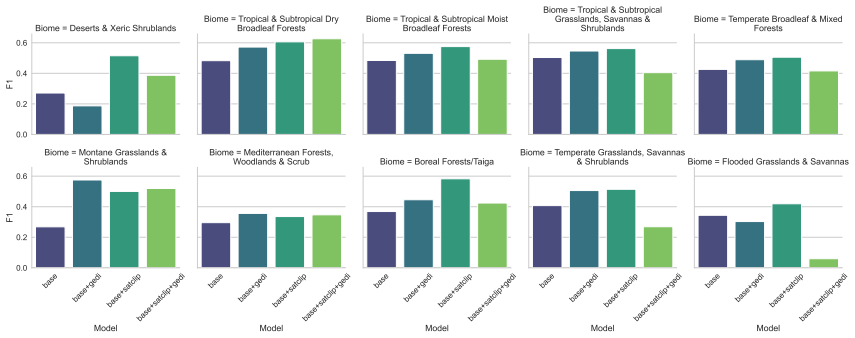
Tree-as-Gaussian heatmap target: every labeled tree center emits a Gaussian kernel with amplitude 1 and σ scaled by crown size; max-pooling forms the full-resolution target heatmap. The model learns this target with a UNet/ResNet50 with two heads: heatmap and spatial uncertainty. The uncertainty head resizes kernels online during training (loss L = MSE(h, y) + δ||s||²), letting the model tolerate crown-size differences and noisy point labels. Around this core sit the CHM local-maxima pseudo-label pipeline (12–14 parameters chosen by Bayesian optimization), SatCLIP location embeddings injected into the decoder features, and negative GEDI supervision on selected non-tree footprints. Peaks of t
What would settle it
A global model can be tested against georeferenced field plots with stem-mapped trees: match detections to stems within 5 m and compute per-biome F1. If closed-canopy or small-crown plots fall far below the reported balanced F1, the claim that the model detects trees with balanced performance across biomes is falsified.
Extended reading notes
Core claim
The paper's central claim: individual trees can be mapped globally from 3 m satellite imagery by treating each tree as a Gaussian blob in a learned heatmap. A UNet/ResNet50 predicts per-pixel heatmap (tree-center chance) and spatial uncertainty; kernels are drawn at labeled positions and resized by predicted uncertainty, absorbing crown-size variation and label noise. Supervision comes from ~14 billion points mined from submeter lidar canopy height models, with Bayesian optimization tuning 12–14 parameters. Best model reaches detection F1 = 0.51 and cover R² = 0.83 against aerial lidar, above compared 10 m products under a universal threshold. The authors present this as the first beyond-nat
Load-bearing premise
The load-bearing premise is that local maxima on submeter airborne-lidar canopy height models, after preprocessing, mark the centers of the individual trees that matter in 3 m imagery; if those pseudo-labels are systematically biased, every reported F1 and R² inherits that bias.
Editorial extensions
If this is right
- Global individual-tree counts become possible: trees both inside dense forests and scattered outside forests are located as points, not only aggregated into cover fractions.
- The same per-pixel heatmap can be thresholded into a 3 m tree-cover map that matches or beats 10 m global products against aerial lidar under a single universal threshold.
- The pretrained model is a reusable initialization: fine-tuning with modest manual labels outperforms training from ImageNet weights across biomes.
- The label-mining and modeling pipeline is not tied to PlanetScope resolution; the same pseudo-labels can supervise detection in future higher-resolution global imagery.
Reading between the lines
- Per-region threshold selection would likely lift detection F1 above the reported 0.51, since the paper shows heatmap confidence varies strongly by area—this is a product decision the paper leaves open.
- The lidar local-maxima label source trains the model on the dominant canopy layer; in dense stands, crown merging likely makes sub-canopy and small-crown trees systematically invisible, so stem-mapped field plots are the real test of the global claim.
- The spatial-uncertainty head could be repurposed as a quality layer in a counting product, telling users where tree counts are reliable and where new imagery or labels are needed.
- Because pseudo-labels come from submeter lidar, reusing the same pipeline on future 1 m-class satellite data should lower the detectable size threshold toward single small trees without new labels.
Editorial analysis
A structured set of objections, weighed in public.
Referee Report
Summary. The paper proposes an anchor-free deep learning system for detecting large individual trees in 3 m PlanetScope imagery at global scale. Tree centers are modeled as Gaussian heatmap targets, with a second head predicting spatial uncertainty to modulate kernel size during training. The model is a U-Net with a ResNet-50 encoder, trained on approximately 14 billion pseudo-labels automatically extracted from airborne lidar canopy height models via local-maxima detection, with optional SatCLIP geographic embeddings and negative GEDI supervision. Evaluation is performed for two tasks: individual tree detection against manual photointerpretation labels (best overall F1 = 0.51) and fractional tree cover mapping against aerial lidar CHMs (R2 = 0.83 with a universal threshold), compared with five existing cover/height products. The paper also demonstrates fine-tuning gains and analyzes hyperparameter sensitivity. The central claim is that this pipeline yields the first global-scale individual tree detection product and competitive cover mapping.
Significance. If the evaluation is trustworthy, the scalable pseudo-label mining and the demonstrated cross-biome generalization are significant contributions: they would provide a practical route to global individual-tree mapping and a strong pretraining scheme for local fine-tuning. The ablations (SatCLIP, GEDI) and the spatial-uncertainty mechanism are useful additions, and the authors are appropriately cautious about the absence of existing baselines at this scale. However, the headline detection and cover numbers rest on pseudo-label fidelity and evaluation protocols that are not yet independently validated; until those are tightened, the quantitative claims should be treated as upper bounds rather than established performance.
major comments (3)
- [Section 2.2 / Section 3.5] Pseudo-label fidelity is the load-bearing risk and is not independently established. The 12–14 CHM preprocessing and detection parameters are tuned against fewer than 5,000 manual labels per CHM collection, and those manual labels are drawn on the same CHM products, so they do not validate local maxima as true individual tree centers. The paper itself states that in dense coniferous forests trees are grouped into clusters (Section 3.5). Since training uses these pseudo-labels, the reported detection F1 conflates model skill with label bias: a model that accurately reproduces CHM local maxima could score well without identifying true individual trees. Please provide independent validation of pseudo-labels (e.g., against sub-meter imagery or field data), stratified by crown closure and canopy density, and quantify merging/omission rates.
- [Section 2.5.1 / Figure 4] The detection evaluation uses a 15 m (5-pixel) matching tolerance and manual labels collected primarily where individual trees can be unambiguously identified. At 3 m GSD this is generous: multiple true trees can fall within 15 m of a single prediction, and one-to-one matching will count only one hit. The reported F1 = 0.51 therefore does not establish that predicted points correspond to true tree centers at the stated resolution. Please report detection metrics under stricter matching criteria (e.g., 5 m and 10 m) and provide quantitative characterization of the label set's bias toward open-canopy vs closed-canopy conditions.
- [Section 2.5.2 / Table 1] The cover mapping comparison is partly a threshold-fitting exercise. Table 1 states that thresholds are selected on a holdout set, and Section 2.5.2 describes a parameter sweep for each product and country. If this sweep is performed on the same data used for the reported R2 values, the headline R2 = 0.83 is an optimistic in-sample estimate. The absence of error bars or significance tests further makes it difficult to distinguish Ours from Tolan et al. (0.78 universal / 0.80 specific) or Pauls et al. (0.78 / 0.90). Please use cross-validated or strictly separate threshold-tuning data and report per-site variance or confidence intervals.
minor comments (6)
- [Abstract / Table 1] The abstract reports fractional cover R2 = 0.81, while Table 1 reports 0.83 for Ours with a universal threshold. Please reconcile the numbers.
- [Section 3.0.1] The sentence 'adding GEDI supervision does improve results (overall F1 = 0.47...)' is ambiguous: it seems to refer to base+GEDI, but the preceding comparison involves base+satclip+gedi. Please clarify which model is being compared and consistently name the variants.
- [Throughout] Typos and grammatical errors: 'explicitely' (Abstract), 'sucesfully' (Introduction), 'transfereable' (Introduction), 'homegeneity' (Section 2.4.2), 'compensed' (Section 3.0.1). A copyedit is needed.
- [Equation (1)] The loss terms are clear, but please define the meaning of y more explicitly and state whether the spatial uncertainty head is trained jointly from the start or after a warm-up; the text says kernels are drawn with the same size initially because the head outputs zero, but the training dynamics should be specified.
- [Section 2.2] The dataset description 'approx. 14 billion trees' should distinguish between detected points, which may include non-tree objects, and verified individual trees; this connects to the pseudo-label validation concern.
- [Table 1] Several R2 values are strongly negative (e.g., Kenya -10.67). This is possible, but a brief explanation or note would help readers interpret product-specific failures in those sites.
Circularity Check
No circular derivation; empirical system with independent held-out evaluation; minor self-cited evaluation data not load-bearing.
full rationale
The paper is an empirical deep-learning system, not an analytic derivation. Training labels are pseudo-labels generated from CHM local maxima (Section 2.2), while detection evaluation uses independent manual photointerpretation labels on PlanetScope imagery (Section 2.5.1), and cover evaluation uses held-out CHMs (Section 2.5.2). The cover thresholds are explicitly fitted on a holdout set (Table 1 note), so the reported R2 is a calibration result rather than an uncorrected prediction, but this is disclosed and applied uniformly to baselines. The only notable self-citation is the detection evaluation dataset 'based on Brandt et al., (2024)' (Section 2.5.1), but this is a manual benchmark, not a fitted parameter or training signal, and thus is not load-bearing in a circular sense. No uniqueness theorem is imported from the authors, no ansatz is smuggled via citation, and no known result is merely renamed. The central claim—that a model trained on automatically mined lidar pseudo-labels can detect trees in 3 m imagery—remains an empirically testable claim with independent evaluation, even though pseudo-label fidelity is a genuine correctness risk.
Assumptions & free parameters
free parameters (5)
- sigma (minimal Gaussian kernel size) =
4.0 m
- delta (Gaussian resizing regularizer) =
0.2
- CHM preprocessing and detection parameters =
not reported; 12 to 14 parameters per lidar collection
- cover mapping thresholds =
global and country-specific values not reported
- detection threshold and minimum point distance =
biome-specific values not fully reported
assumptions (6)
- domain assumption Local maxima on preprocessed CHMs correspond to individual tree centers.
- domain assumption A Gaussian kernel at each tree center, max-pooled across trees, is a valid regression target for tree center detection.
- domain assumption Trees visible in 3 m PlanetScope imagery are a noisy but usable subset of trees detected in submeter lidar CHMs.
- domain assumption Manual photointerpretation of PlanetScope imagery provides valid ground truth for evaluating tree detection.
- domain assumption GEDI waveforms with one detected mode and RH98 below 2.5 m imply no tree is present.
- domain assumption SatCLIP location embeddings supply useful geographic priors for tree appearance.
Cite this review
Pith. "Pith review of Trees as Gaussians: Large-Scale Individual Tree Mapping." pith.science (2026). https://pith.science/paper/GGQO5LT7
@misc{pith2026250821437,
  author       = {Pith},
  title        = {Pith review of: Trees as Gaussians: Large-Scale Individual Tree Mapping},
  year         = {2026},
  howpublished = {\url{https://pith.science/paper/GGQO5LT7}},
  note         = {Machine review of arXiv:2508.21437}
}
abstract
Trees are key components of the terrestrial biosphere, playing vital roles in ecosystem function, climate regulation, and the bioeconomy. However, large-scale monitoring of individual trees remains limited by inadequate modelling. Available global products have focused on binary tree cover or canopy height, which do not explicitely identify trees at individual level. In this study, we present a deep learning approach for detecting large individual trees in 3-m resolution PlanetScope imagery at a global scale. We simulate tree crowns with Gaussian kernels of scalable size, allowing the extraction of crown centers and the generation of binary tree cover maps. Training is based on billions of points automatically extracted from airborne lidar data, enabling the model to successfully identify trees both inside and outside forests. We compare against existing tree cover maps and airborne lidar with state-of-the-art performance (fractional cover R$^2 = 0.81$ against aerial lidar), report balanced detection metrics across biomes, and demonstrate how detection can be further improved through fine-tuning with manual labels. Our method offers a scalable framework for global, high-resolution tree monitoring, and is adaptable to future satellite missions offering improved imagery.
Figures


Figures from the paper (8 more)


Reference graph
Works this paper leans on
-
[1]
Wang X, Hua F, Wang L, Wilcove DS, and Yu DW. The biodiversity benefit of native forests and mixed-species plantations over monoculture plantations. Diversity and Distributions 2019;25. eprint: https://onlinelibrary.wiley.com/doi/pdf/10.1111/ddi.12972:1721–35
-
[2]
A Planetary Health Perspective on Agroforestry in Sub-Saharan Africa
Rosenstock TS, Dawson IK, Aynekulu E, et al. A Planetary Health Perspective on Agroforestry in Sub-Saharan Africa. One Earth 2019;1:330–44
work page 2019
-
[3]
Mugabowindekwe M, Brandt M, Mukuralinda A, et al. Trees on smallholder farms and forest restoration are critical for Rwanda to achieve net zero emissions. Communications Earth & Environment 2024;5:113. 1https://rs-cph.projects.earthengine.app/view/treecover 15
work page 2024
-
[4]
High-Resolution Global Maps of 21st-Century Forest Cover Change
Hansen MC, Potapov PV, Moore R, et al. High-Resolution Global Maps of 21st-Century Forest Cover Change. Science 2013;342. eprint: https://www.science.org/doi/pdf/10.1126/science.1244693:850– 3
-
[5]
Wall-to-wall mapping of tree extent in the tropics with Sentinel-1 and Sentinel-2
Brandt J, Ertel J, Spore J, and Stolle F. Wall-to-wall mapping of tree extent in the tropics with Sentinel-1 and Sentinel-2. Remote Sensing of Environment 2023;292:113574
work page 2023
-
[6]
A high-resolution canopy height model of the Earth
Lang N, Jetz W, Schindler K, and Wegner JD. A high-resolution canopy height model of the Earth. Nature Ecology & Evolution 2023. Publisher: Nature Publishing Group UK London:1– 12
work page 2023
-
[7]
Tolan J, Yang HI, Nosarzewski B, et al. Very high resolution canopy height maps from RGB imagery using self-supervised vision transformer and convolutional decoder trained on aerial lidar. Remote Sensing of Environment 2024;300:113888
work page 2024
-
[8]
Estimating Canopy Height at Scale
Pauls J, Zimmer M, Kelly UM, et al. Estimating Canopy Height at Scale. In: Proceedings of the 41st International Conference on Machine Learning . Ed. by Salakhutdinov R, Kolter Z, Heller K, et al. Vol. 235. Proceedings of Machine Learning Research. PMLR, 2024:39972–88. url: https://proceedings.mlr.press/v235/pauls24a.html
work page 2024
Show all 31 references
-
[9]
Mapping tropical forest degradation with deep learning and Planet NICFI data
Dalagnol R, Wagner FH, Galv˜ ao LS, et al. Mapping tropical forest degradation with deep learning and Planet NICFI data. Remote Sensing of Environment 2023;298:113798
2023
-
[10]
An unexpectedly large count of trees in the West African Sahara and Sahel
Brandt M, Tucker CJ, Kariryaa A, et al. An unexpectedly large count of trees in the West African Sahara and Sahel. Nature 2020;587. Number: 7832 Publisher: Nature Publishing Group:78– 82
2020
-
[11]
More than one quarter of Africa’s tree cover is found outside areas previously classified as forest
Reiner F, Brandt M, Tong X, et al. More than one quarter of Africa’s tree cover is found outside areas previously classified as forest. Nature Communications 2023;14:2258
2023
-
[12]
Nation-wide mapping of tree-level aboveground carbon stocks in Rwanda
Mugabowindekwe M, Brandt M, Chave J, et al. Nation-wide mapping of tree-level aboveground carbon stocks in Rwanda. Nature Climate Change 2023;13. Number: 1 Publisher: Nature Pub- lishing Group:91–7
2023
-
[13]
Severe decline in large farmland trees in India over the past decade
Brandt M, Gominski D, Reiner F, et al. Severe decline in large farmland trees in India over the past decade. Nature Sustainability 2024
2024
-
[14]
A remote sensing derived data set of 100 million individual tree crowns for the National Ecological Observatory Network
Weinstein BG, Marconi S, Bohlman SA, et al. A remote sensing derived data set of 100 million individual tree crowns for the National Ecological Observatory Network. eLife 2021;10. Ed. by Schmid B, Schuman MC, and Schmid B. Publisher: eLife Sciences Publications, Ltd:e62922
2021
-
[15]
Braga JR, Peripato V, Dalagnol R, et al
G. Braga JR, Peripato V, Dalagnol R, et al. Tree Crown Delineation Algorithm Based on a Con- volutional Neural Network. Remote Sensing 2020;12. Number: 8 Publisher: Multidisciplinary Digital Publishing Institute:1288
2020
- [16]
-
[17]
CornerNet: Detecting Objects as Paired Keypoints
Law H and Deng J. CornerNet: Detecting Objects as Paired Keypoints. International Journal of Computer Vision 2020;128:642–56. 16
2020
-
[18]
Comparison of Tree Species Classifications at the Individual Tree Level by Combining ALS Data and RGB Images Using Different Algo- rithms
Deng S, Katoh M, Yu X, Hyypp¨ a J, and Gao T. Comparison of Tree Species Classifications at the Individual Tree Level by Combining ALS Data and RGB Images Using Different Algo- rithms. Remote Sensing 2016;8:1034
2016
-
[19]
U-Net: Convolutional Networks for Biomedical Image Segmentation
Ronneberger O, Fischer P, and Brox T. U-Net: Convolutional Networks for Biomedical Image Segmentation. In: Medical Image Computing and Computer-Assisted Intervention – MICCAI
-
[20]
Deep Residual Learning for Image Recognition
He K, Zhang X, Ren S, and Sun J. Deep Residual Learning for Image Recognition. In: 2016 IEEE Conference on Computer Vision and Pattern Recognition (CVPR) . 2016:770–8. doi: 10.1109/CVPR.2016.90
2016 doi
-
[21]
OmniSat: Self-supervised Modality Fusion for Earth Observation
Astruc G, Gonthier N, Mallet C, and Landrieu L. OmniSat: Self-supervised Modality Fusion for Earth Observation. In: Computer Vision – ECCV 2024 . Ed. by Leonardis A, Ricci E, Roth S, Russakovsky O, Sattler T, and Varol G. Cham: Springer Nature Switzerland, 2025:409–27
2024
-
[22]
GPS2Vec: Towards Generating Worldwide GPS Embeddings
Yin Y, Liu Z, Zhang Y, Wang S, Shah RR, and Zimmermann R. GPS2Vec: Towards Generating Worldwide GPS Embeddings. In: Proceedings of the 27th ACM SIGSPATIAL International Conference on Advances in Geographic Information Systems . SIGSPATIAL ’19. event-place: Chicago, IL, USA. Ne...
2019
-
[23]
SatCLIP: Global, General- Purpose Location Embeddings with Satellite Imagery
Klemmer K, Rolf E, Robinson C, Mackey L, and Rußwurm M. SatCLIP: Global, General- Purpose Location Embeddings with Satellite Imagery. eprint: 2311.17179. 2024. url: https: //arxiv.org/abs/2311.17179
2024 arXiv
-
[24]
Learning Transferable Visual Models From Natural Lan- guage Supervision
Radford A, Kim JW, Hallacy C, et al. Learning Transferable Visual Models From Natural Lan- guage Supervision. In: Proceedings of the 38th International Conference on Machine Learning . Ed. by Meila M and Zhang T. Vol. 139. Proceedings of Machine Learning Research. PMLR, 2021:8...
2021
-
[25]
ESA WorldCover 10 m 2020 v100
Zanaga D, Van De Kerchove R, De Keersmaecker W, et al. ESA WorldCover 10 m 2020 v100. Version v100. Zenodo, 2021. doi: 10.5281/zenodo.5571936 . url: https://doi.org/10. 5281/zenodo.5571936
2020 doi
-
[26]
Mapping global forest cover of the year 2020 to support the EU regulation on deforestation-free supply chains
Bourgoin C, Ameztoy I, Verhegghen A, et al. Mapping global forest cover of the year 2020 to support the EU regulation on deforestation-free supply chains. Publications Office of the European Union, 2024. doi: doi/10.2760/262532
2020 doi
-
[27]
Individual tree detection in large-scale urban envi- ronments using high-resolution multispectral imagery
Ventura J, Pawlak C, Honsberger M, et al. Individual tree detection in large-scale urban envi- ronments using high-resolution multispectral imagery. International Journal of Applied Earth Observation and Geoinformation 2024;130:103848
2024
-
[28]
Assessing the Sharpness of Satellite Images: Study of the Planetscope Constellation
Anger J, Franchis C de, and Facciolo G. Assessing the Sharpness of Satellite Images: Study of the Planetscope Constellation. In: IGARSS 2019 - 2019 IEEE International Geoscience and Remote Sensing Symposium . 2019:389–92. doi: 10.1109/IGARSS.2019.8900526
2019
-
[29]
Foundation Models for Generalist Geospatial Artificial Intelligence
Jakubik J, Roy S, Phillips CE, et al. Foundation Models for Generalist Geospatial Artificial Intelligence. Preprint Available on arxiv:2310.18660 2023. 17
2023 arXiv
-
[30]
MMEarth: Exploring multi-modal pretext tasks for geospatial representation learning
Nedungadi V, Kariryaa A, Oehmcke S, Belongie S, Igel C, and Lang N. MMEarth: Exploring multi-modal pretext tasks for geospatial representation learning. In: European Conference on Computer Vision . Springer, 2024:164–82. 18
2024
-
[2015]
by Navab N, Hornegger J, Wells WM, and Frangi AF
Ed. by Navab N, Hornegger J, Wells WM, and Frangi AF. Lecture Notes in Computer Science. Cham: Springer International Publishing, 2015:234–41
2015
Reviewed August 5, 2026 · model on record in the stance chip above.
Discussion (0). Sign in to comment.