Damage-TriageFormer: A Foundation-Model Framework for Typology-Based Building Damage Assessment from Mono-Temporal Imagery
Pith reviewed 2026-06-27 10:18 UTC · model grok-4.3
The pith
A single post-event image conditioned on building footprints can classify damage into five typology classes separating roof from structural damage and partial from total extent.
A machine-rendered reading of the paper's core claim, the machinery that carries it, and where it could break.
Core claim
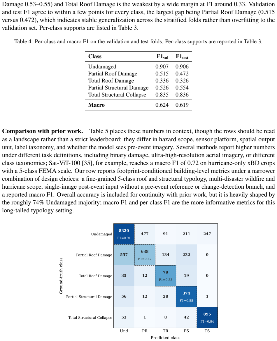
Damage-TriageFormer shows that mono-temporal post-event imagery, together with building footprint conditioning, can assign structures to one of five damage typology classes that distinguish roof damage from structural damage while further separating partial from total extent within each category. The model reaches macro F1 of 0.624 on validation and 0.619 on held-out test data, with per-class F1 of 0.91 on undamaged buildings and 0.84 on total structural collapse. These outcomes indicate that actionable damage typing for targeted emergency response is feasible without paired pre-event imagery.
What carries the argument
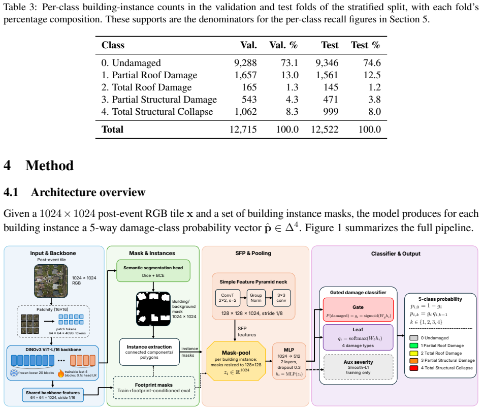
Damage-TriageFormer, a footprint-conditioned architecture built on a vision transformer backbone with a simple feature pyramid for higher-resolution instance pooling, a two-stage gated damage head, and an auxiliary severity-regression objective.
If this is right
- Targeted emergency response becomes feasible by flagging total structural collapse separately from roof-only damage.
- Resource allocation can proceed without waiting for pre-event reference imagery.
- The typology supplies more actionable granularity than standard severity scales for recovery planning.
- Strong performance holds on undamaged buildings and total collapse across the benchmark events.
- The approach works for both hurricane and wildfire imagery in the collected data.
Where Pith is reading between the lines
- The same single-image conditioning could be tested on damage to roads or power infrastructure using analogous footprint data.
- Additional labeled examples for the rare total-roof-damage class might reduce the current performance gap without changing the overall architecture.
- Output from the typology model could be combined with ground reports to resolve ambiguous cases in near-real time.
Load-bearing premise
The five typology classes have sufficiently consistent and visually distinguishable boundaries in mono-temporal imagery that a model can learn them reliably.
What would settle it
A new disaster dataset in which the model achieves F1 below 0.4 on the total-roof-damage class or shows no reliable separation between roof and structural categories would falsify the claim that the typology is learnable from single images.
Figures
read the original abstract
Decision-relevant building damage assessment is critical for prioritizing resources and recovery after a disaster, yet most automated methods either flatten damage into a single severity scale (no damage, minor, major, destroyed) or require paired pre- and post-event imagery that is often unavailable for emerging hazards. This paper presents Damage-TriageFormer, a single-image, post-event, footprint-conditioned model that produces a damage typology rather than a severity scale. We contribute: (1) DamageTriage-Bench, a new benchmark built from NOAA Emergency Response Imagery across Hurricane Michael (2018), Hurricane Helene (2024), and the 2025 Los Angeles wildfire complex, with five typology classes that distinguish roof damage from structural damage and, within each, partial from total extent; and (2) Damage-TriageFormer, which extends a DINOv3 ViT-L backbone with a Simple Feature Pyramid for higher-resolution instance pooling, a two-stage gated damage head, and an auxiliary severity-regression objective. Our model achieves macro F1 of 0.624 on validation and 0.619 on a held-out stratified test set, performing strongest where operational triage needs it most, with per-class F1 of 0.91 and 0.84 on undamaged buildings and total structural collapse, respectively. While the rare Total Roof Damage class remains difficult due to its limited examples and an inherently ambiguous label boundary, our results show that single-image post-event imagery can support actionable building damage typing, enabling targeted emergency response and resource allocation without a pre-event reference.
Editorial analysis
A structured set of objections, weighed in public.
Referee Report
Summary. The paper introduces DamageTriage-Bench, a new five-class damage typology benchmark (undamaged, partial/total roof damage, partial/total structural damage) constructed from NOAA post-event imagery across Hurricane Michael (2018), Hurricane Helene (2024), and the 2025 Los Angeles wildfire complex. It presents Damage-TriageFormer, which adapts a DINOv3 ViT-L backbone with a Simple Feature Pyramid, two-stage gated damage head, and auxiliary severity-regression loss, and reports macro F1 scores of 0.624 (validation) and 0.619 (stratified held-out test), with per-class F1 of 0.91 (undamaged) and 0.84 (total structural collapse). The central claim is that mono-temporal post-event imagery alone can support actionable building damage typing for emergency triage without pre-event references.
Significance. If label consistency and visual distinguishability hold, the work would be significant for operational disaster response by removing the pre/post pairing requirement that is frequently unavailable. The multi-event benchmark and strong performance on the two most triage-critical classes (undamaged and total collapse) are concrete strengths. The held-out stratified test set and reporting of both macro and per-class metrics provide a reproducible evaluation protocol that future work can build upon.
major comments (2)
- [Abstract] Abstract: The reported macro F1 of 0.619 on the held-out test set is presented without inter-annotator agreement, label-protocol documentation, or data-exclusion criteria for the five typology classes. This is load-bearing because the abstract itself flags an 'inherently ambiguous label boundary' and 'limited examples' for Total Roof Damage; without these quantifications it is unclear whether the F1 scores reflect stable visual cues in the imagery or annotation noise.
- [Abstract] Abstract: No ablation is shown for the auxiliary severity-regression loss weight or for the contribution of the Simple Feature Pyramid / gated head relative to the DINOv3 backbone alone. Because the central claim rests on the model's ability to learn the typology from mono-temporal imagery, the absence of these controls leaves open whether the 0.619 macro F1 is driven by the proposed architecture or by the pre-trained backbone.
minor comments (1)
- [Abstract] Abstract: Only two per-class F1 values are stated; reporting the full five-class breakdown (including partial roof and partial structural) on both validation and test sets would allow readers to assess whether the typology is uniformly actionable.
Simulated Author's Rebuttal
We thank the referee for the constructive feedback and for recognizing the operational relevance of the mono-temporal benchmark and the model's strength on the most triage-critical classes. We address each major comment below with concrete plans for revision where appropriate.
read point-by-point responses
-
Referee: [Abstract] Abstract: The reported macro F1 of 0.619 on the held-out test set is presented without inter-annotator agreement, label-protocol documentation, or data-exclusion criteria for the five typology classes. This is load-bearing because the abstract itself flags an 'inherently ambiguous label boundary' and 'limited examples' for Total Roof Damage; without these quantifications it is unclear whether the F1 scores reflect stable visual cues in the imagery or annotation noise.
Authors: We agree that explicit documentation of label quality is important. Section 3.2 of the manuscript already describes the annotation protocol (NOAA imagery interpreted by domain experts following standardized damage typology guidelines) and Section 3.3 details the data exclusion criteria (e.g., footprints with insufficient visible structure or heavy occlusion). Inter-annotator agreement was not computed because the annotations were produced by a single coordinated expert team using a fixed protocol rather than multiple independent annotators. We will revise the abstract to include a one-sentence reference to the label-protocol documentation and exclusion criteria in the main text, while retaining the existing acknowledgment of the ambiguous boundary and limited samples for Total Roof Damage. revision: partial
-
Referee: [Abstract] Abstract: No ablation is shown for the auxiliary severity-regression loss weight or for the contribution of the Simple Feature Pyramid / gated head relative to the DINOv3 backbone alone. Because the central claim rests on the model's ability to learn the typology from mono-temporal imagery, the absence of these controls leaves open whether the 0.619 macro F1 is driven by the proposed architecture or by the pre-trained backbone.
Authors: We concur that targeted ablations would better isolate the contribution of the proposed components. In the revised manuscript we will add a new ablation table (in Section 4.3) that reports macro F1 for (i) the plain DINOv3 ViT-L baseline, (ii) baseline + Simple Feature Pyramid, (iii) baseline + gated head, (iv) full model without auxiliary loss, and (v) full model with auxiliary loss at three different weights (0.1, 0.5, 1.0). This will directly quantify the incremental gains from each architectural choice and the auxiliary objective. revision: yes
Circularity Check
No significant circularity detected
full rationale
The paper introduces DamageTriage-Bench as a new dataset and reports model performance (macro F1 0.624/0.619) on a held-out stratified test set drawn from that benchmark. No equations, procedures, or self-citations are described that reduce the central performance claims to quantities defined by construction from the same fitted parameters, self-referential definitions, or load-bearing prior work by the same authors. Standard supervised evaluation on held-out data does not trigger any of the enumerated circularity patterns.
Axiom & Free-Parameter Ledger
free parameters (1)
- auxiliary severity-regression loss weight
axioms (2)
- domain assumption Building footprints are available and accurately aligned with the imagery to condition instance-level predictions.
- domain assumption The five typology classes possess visually learnable distinctions in post-event mono-temporal imagery.
Reference graph
Works this paper leans on
-
[1]
Developing a Framework for Rapid Collapsed Building Mapping Using Satellite Imagery and Deep Learning Models
Bruno Adriano, Hiroyuki Miura, Wen Liu, Masashi Matsuoka, and Shunichi Koshimura. Developing a Framework for Rapid Collapsed Building Mapping Using Satellite Imagery and Deep Learning Models. InIGARSS 2023 - 2023 IEEE International Geoscience and Remote Sensing Symposium, pages 1273–1276, Pasadena, CA, USA, July 2023. IEEE
2023
-
[2]
Generalizable Disaster Damage Assessment via Change Detection with Vision Foundation Model, January 2025
Kyeongjin Ahn, Sungwon Han, Sungwon Park, Jihee Kim, Sangyoon Park, and Meeyoung Cha. Generalizable Disaster Damage Assessment via Change Detection with Vision Foundation Model, January 2025
2025
-
[3]
DamageScope: An integrated pipeline for building damage segmentation, geospatial mapping, and interactive web-based visualization.Remote Sensing, 17(13):2267, 2025
Sami Al Shafian. DamageScope: An integrated pipeline for building damage segmentation, geospatial mapping, and interactive web-based visualization.Remote Sensing, 17(13):2267, 2025
2025
-
[4]
Integrating Machine Learning and Remote Sensing in Disaster Man- agement: A Decadal Review of Post-Disaster Building Damage Assessment.Buildings, 14(8):2344, August 2024
Sultan Al Shafian and Da Hu. Integrating Machine Learning and Remote Sensing in Disaster Man- agement: A Decadal Review of Post-Disaster Building Damage Assessment.Buildings, 14(8):2344, August 2024
2024
-
[5]
Irene Alisjahbana, Jiawei Li, Ben Strong, and Yue Zhang. DeepDamageNet: A two-step deep-learning model for multi-disaster building damage segmentation and classification using satellite imagery.arXiv preprint arXiv:2405.04800, 2024
arXiv 2024
-
[6]
Field manual: Safety evaluation of buildings after windstorms and floods (atc-45)
Applied Technology Council. Field manual: Safety evaluation of buildings after windstorms and floods (atc-45). Technical report, Applied Technology Council, Redwood City, CA, 2004
2004
-
[7]
Bay County, Florida GIS Open Data
Bay County, Florida. Bay County, Florida GIS Open Data. https://www.baycountyfl.gov/177/ Geographic-Information-Systems-GIS , 2019. County-level building footprints and parcels for the area most affected by Hurricane Michael. Accessed: 2026-05-20
2019
-
[8]
Braik and Maria Koliou
Abdullah M. Braik and Maria Koliou. Automated building damage assessment and large-scale mapping by integrating satellite imagery, GIS, and deep learning.Computer-Aided Civil and Infrastructure Engineering, 39(15):2389–2404, 2024. 14
2024
-
[9]
Chang, Ronald T
Michel Bruneau, Stephanie E. Chang, Ronald T. Eguchi, George C. Lee, Thomas D. O’Rourke, Andrei M. Reinhorn, Masanobu Shinozuka, Kathleen Tierney, William A. Wallace, and Detlof von Winterfeldt. A framework to quantitatively assess and enhance the seismic resilience of communities. Earthquake Spectra, 19(4):733–752, 2003
2003
-
[10]
HRTBDA: A network for post-disaster building damage assessment based on remote sensing images.International Journal of Digital Earth, 17(1):2418880, December 2024
Fang Chen, Yao Sun, Lei Wang, Ning Wang, Huichen Zhao, and Bo Yu. HRTBDA: A network for post-disaster building damage assessment based on remote sensing images.International Journal of Digital Earth, 17(1):2418880, December 2024
2024
-
[11]
ChangeMamba: Remote Sensing Change Detection With Spatiotemporal State Space Model, December 2024
Hongruixuan Chen, Jian Song, Chengxi Han, Junshi Xia, and Naoto Yokoya. ChangeMamba: Remote Sensing Change Detection With Spatiotemporal State Space Model, December 2024
2024
-
[12]
Reinhorn, and Michel Bruneau
Gian Paolo Cimellaro, Andrei M. Reinhorn, and Michel Bruneau. Framework for analytical quantifica- tion of disaster resilience.Engineering Structures, 32(11):3639–3649, 2010
2010
-
[13]
Lobell, and Stefano Ermon
Yezhen Cong, Samar Khanna, Chenlin Meng, Patrick Liu, Erik Rozi, Yutong He, Marshall Burke, David B. Lobell, and Stefano Ermon. SatMAE: Pre-training Transformers for Temporal and Multi- Spectral Satellite Imagery, January 2023
2023
-
[14]
Conditional Experts for Improved Building Damage Assessment Across Satellite Imagery View Angles
Philipe Dias, Jacob Arndt, Marie Urban, and Dalton Lunga. Conditional Experts for Improved Building Damage Assessment Across Satellite Imagery View Angles. InIGARSS 2024 - 2024 IEEE International Geoscience and Remote Sensing Symposium, pages 1741–1745, Athens, Greece, July 2024. IEEE
2024
-
[15]
Multi-hazard loss estimation methodology, hurricane model (hazus-mh 2.1): Technical manual
Federal Emergency Management Agency. Multi-hazard loss estimation methodology, hurricane model (hazus-mh 2.1): Technical manual. Technical report, Federal Emergency Management Agency, Wash- ington, DC, 2012
2012
-
[16]
Andrew Fricker
Marios Galanis, Krishna Rao, Xinle Yao, Yi-Lin Tsai, Jonathan Ventura, and G. Andrew Fricker. DamageMap: A post-wildfire damaged buildings classifier.International Journal of Disaster Risk Reduction, 65:102540, 2021
2021
-
[17]
Advances in Rapid Damage Identification Methods for Post-Disaster Regional Buildings Based on Remote Sensing Images: A Survey.Buildings, 14(4):898, March 2024
Jiancheng Gu, Zhengtao Xie, Jiandong Zhang, and Xinhao He. Advances in Rapid Damage Identification Methods for Post-Disaster Regional Buildings Based on Remote Sensing Images: A Survey.Buildings, 14(4):898, March 2024
2024
-
[18]
Creating xBD: A dataset for assessing building damage from satellite imagery
Ritwik Gupta, Bryce Goodman, Nirav Patel, Ricky Hosfelt, Sandra Sajeev, Eric Heim, Jigar Doshi, Keane Lucas, Howie Choset, and Matthew Gaston. Creating xBD: A dataset for assessing building damage from satellite imagery. InProceedings of the IEEE/CVF Conference on Computer Vision and Pattern Recognition (CVPR) Workshops, pages 10–17, 2019
2019
-
[19]
Ritwik Gupta, Richard Hosfelt, Sandra Sajeev, Nirav Patel, Bryce Goodman, Jigar Doshi, Eric Heim, Howie Choset, and Matthew Gaston. xBD: A dataset for assessing building damage from satellite imagery.arXiv preprint arXiv:1911.09296, 2019
arXiv 1911
-
[20]
Post-disaster building damage assessment: Multi-class object detection vs
Damjan Hati´c, Vladyslav Polushko, Markus Rauhut, and Hans Hagen. Post-disaster building damage assessment: Multi-class object detection vs. object localization and classification.Remote Sensing, 17(24), 2025
2025
-
[21]
Classification of building damage using a novel convolutional neural network based on post-disaster aerial images.Sensors, 22(15):5920, 2022
Zhonghua Hong, Hongzheng Zhong, Haiyan Pan, Jun Liu, Ruyan Zhou, Yun Zhang, Yanling Han, Jing Wang, Shuhu Yang, and Changyue Zhong. Classification of building damage using a novel convolutional neural network based on post-disaster aerial images.Sensors, 22(15):5920, 2022. 15
2022
-
[22]
Navjot Kaur, Cheng-Chun Lee, Ali Mostafavi, and Ali Mahdavi-Amiri. Large-scale building damage assessment using a novel hierarchical transformer architecture on satellite images.Computer-Aided Civil and Infrastructure Engineering, 38(15):2072–2091, October 2023
2072
-
[23]
Exploring Plain Vision Transformer Backbones for Object Detection, June 2022
Yanghao Li, Hanzi Mao, Ross Girshick, and Kaiming He. Exploring Plain Vision Transformer Backbones for Object Detection, June 2022
2022
-
[24]
2023 Buildings with DINS data (Palisades and Eaton Fires)
Los Angeles County Enterprise GIS. 2023 Buildings with DINS data (Palisades and Eaton Fires). https://data.lacounty.gov/datasets/lacounty::2023-buildings-with-dins-data- ,
2023
-
[25]
Accessed: 2026-05-20
Building footprints with CAL FIRE Damage Inspection (DINS) attributes as of 2025-01-27. Accessed: 2026-05-20
2025
-
[26]
Gerg, Chen Zhao, Russell Blue, Anthony Hoogs, Brian Clipp, and Philip Morrone
Dennis Melamed, Cameron Johnson, Isaac D. Gerg, Chen Zhao, Russell Blue, Anthony Hoogs, Brian Clipp, and Philip Morrone. Uncovering Bias in Building Damage Assessment from Satellite Imagery. In IGARSS 2024 - 2024 IEEE International Geoscience and Remote Sensing Symposium, pages 8095–8099, Athens, Greece, July 2024. IEEE
2024
-
[27]
Long-tail learning via logit adjustment, July 2021
Aditya Krishna Menon, Sadeep Jayasumana, Ankit Singh Rawat, Himanshu Jain, Andreas Veit, and Sanjiv Kumar. Long-tail learning via logit adjustment, July 2021
2021
-
[28]
Amir Mohammadian and Foad Ghaderi. SiamixFormer: A fully-transformer Siamese network with temporal Fusion for accurate building detection and change detection in bi-temporal remote sensing images.International Journal of Remote Sensing, 44(12):3660–3678, June 2023
2023
-
[29]
Community resilience planning guide for buildings and infrastructure systems
National Institute of Standards and Technology. Community resilience planning guide for buildings and infrastructure systems. NIST Special Publication 1190, National Institute of Standards and Technology, Gaithersburg, MD, 2016
2016
-
[30]
Emergency response imagery
NOAA National Geodetic Survey. Emergency response imagery. https://coast.noaa.gov/ digitalcoast/data/emergency.html. Accessed 2026-05-18
2026
-
[31]
NC Building Footprints
North Carolina Emergency Management and NC OneMap. NC Building Footprints. https: //www.nconemap.gov/datasets/NCEM-GIS::nc-buildings-footprints , 2024. Statewide build- ing footprints derived from QL1/QL2 LiDAR. Accessed: 2026-05-20
2024
-
[32]
Victor Oludare, Landry Kezebou, Obafemi Jinadu, Karen Panetta, and Sos S. Agaian. Attention-based two-stream high-resolution networks for building damage assessment from satellite imagery. In Sos S. Agaian, Sabah A. Jassim, Stephen P. DelMarco, and Vijayan K. Asari, editors,Multimodal Image Exploitation and Learning 2022, page 27, Orlando, United States, ...
2022
-
[33]
Scalable approach to create annotated disaster image database supporting AI-driven damage assessment.Natural Hazards, 120(13):11693–11712, October 2024
Sun Ho Ro and Jie Gong. Scalable approach to create annotated disaster image database supporting AI-driven damage assessment.Natural Hazards, 120(13):11693–11712, October 2024
2024
-
[34]
Yu Shen, Sijie Zhu, Taojiannan Yang, Chen Chen, Delu Pan, Jianyu Chen, Liang Xiao, and Qian Du. BDANet: Multiscale Convolutional Neural Network with Cross-directional Attention for Building Damage Assessment from Satellite Images.IEEE Transactions on Geoscience and Remote Sensing, 60:1–14, 2022
2022
-
[35]
Oriane Siméoni, Huy V . V o, Maximilian Seitzer, Federico Baldassarre, Maxime Oquab, Cijo Jose, Vasil Khalidov, Marc Szafraniec, Seungeun Yi, Michaël Ramamonjisoa, Francisco Massa, Daniel Haziza, Luca Wehrstedt, Jianyuan Wang, Timothée Darcet, Théo Moutakanni, Leonel Sentana, Claire Roberts, Andrea Vedaldi, Jamie Tolan, John Brandt, Camille Couprie, Julie...
2025
-
[36]
Post disaster damage assessment using ultra-high-resolution aerial imagery with semi-supervised transformers.Sensors, 23(19):8235, 2023
Deepank Kumar Singh and Vedhus Hoskere. Post disaster damage assessment using ultra-high-resolution aerial imagery with semi-supervised transformers.Sensors, 23(19):8235, 2023
2023
-
[37]
Smriti Siva and Jan Cross-Zamirski. Building damage detection using satellite images and patch-based transformer methods.arXiv preprint arXiv:2602.08117, 2026
arXiv 2026
-
[38]
Uhl and Stefan Leyk
Johannes H. Uhl and Stefan Leyk. MTBF-33: A multi-temporal building footprint dataset for 33 counties in the united states (1900–2015).Data in Brief, 43:108369, 2022
1900
-
[39]
Lili Wang, Jidong Wu, Youtian Yang, Rumei Tang, and Ru Ya. Deep Learning Models for Hazard- Damaged Building Detection Using Remote Sensing Datasets: A Comprehensive Review.IEEE Journal of Selected Topics in Applied Earth Observations and Remote Sensing, 17:15301–15318, 2024
2024
-
[40]
Building damage detection from satellite images after natural disasters on extremely imbalanced datasets.Automation in Construction, 140:104328, August 2022
Ying Wang, Alvin Wei Ze Chew, and Limao Zhang. Building damage detection from satellite images after natural disasters on extremely imbalanced datasets.Automation in Construction, 140:104328, August 2022
2022
-
[41]
Self-Supervised Learning for Building Damage Assessment from Large-scale xBD Satellite Imagery Benchmark Datasets, June 2022
Zaishuo Xia, Zelin Li, Yanbing Bai, Jinze Yu, and Bruno Adriano. Self-Supervised Learning for Building Damage Assessment from Large-scale xBD Satellite Imagery Benchmark Datasets, June 2022
2022
-
[42]
Yiming Xiao and Ali Mostafavi. DamageCAT: A deep learning transformer framework for typology- based post-disaster building damage categorization.arXiv preprint arXiv:2504.11637, 2025
arXiv 2025
-
[43]
Prevatt, Jennifer Bridge, Susu Xu, and Xilei Zhao
Zhuoqun Xue, Xiaojian Zhang, David O. Prevatt, Jennifer Bridge, Susu Xu, and Xilei Zhao. Post- hurricane building damage assessment using street-view imagery and structured data: A multi-modal deep learning approach, April 2024. 17
2024
discussion (0)
Sign in with ORCID, Apple, or X to comment. Anyone can read and Pith papers without signing in.