REVIEW 4 major objections 4 minor 40 references
LoRFT: Benchmarking Long-Range Vehicle Trajectory Reconstruction from Fixed Highway Cameras
T0 review · 4 major / 4 minor · reviewed 2026-08-01 · deepseek-v4-flash
Pith's one-line read A map-aware model reconstructs distant vehicle trajectories in fixed highway camera views, cutting final error by 15.4%, on a new public benchmark.
desk verdict LoRFT is a genuinely novel benchmark with a clean protocol; the reported gains are credible but sit close to an unquantified annotation-noise floor. read the letter →
The pith
A machine-rendered reading of the paper's core claim, the machinery that carries it, and where it could break.
The reading
What carries the argument
The key mechanism is the road-aligned state space: each trajectory point is expressed as a lateral fraction of local road width, a normalized vertical coordinate, scale terms, velocities, and geometry features (distance to left/right boundaries, heading difference from the road centerline). The decoder autoregressively predicts residual displacements in this normalized space, with a hard step limit and a boundary-loss regularizer. During decoding, 'dynamic geometry refresh' re-queries the scene road prior at each predicted position, keeping the reconstructed path aligned with the actual road shape and preventing error accumulation over long horizons.
What would settle it
Re-annotate a random subset of far-range trajectory frames with multiple annotators, compute per-point standard deviations, and compare them to the reported ADE (12.3 px) and FDE (21.7 px). If the annotation noise floor is a large share of those numbers (e.g., >30%), the benchmark cannot confidently distinguish Map-RSTNet from the best baseline; if it is small, the claims stand.
Extended reading notes
Core claim
The central claim is that road-geometry-aware reconstruction is a practical way to recover the distant segment of a vehicle trajectory from a reliable near-field tracklet within one fixed-camera view. LoRFT provides 6,601 manually verified trajectories, pairing reliable near-field observations with context-verified far-range references, along with road-geometry annotations, scene-level splits, and evaluation scripts. Map-RSTNet encodes trajectories in a road-aligned state space, uses relative residual decoding, and dynamically refreshes road geometry at every decoding step. On the benchmark, this yields consistent improvements over adapted forecasting and imputation baselines, with the large
Load-bearing premise
The manually verified far-range reference annotations are accurate enough that pixel errors of roughly 12–27 truly reflect model performance; if annotator localization noise is a substantial fraction of these errors, the benchmark's ability to rank methods—and the headline 10–15% gains—would be smaller than they appear.
Editorial extensions
If this is right
- Existing fixed highway camera infrastructure can provide longer trajectory records for safety analysis and traffic management without additional sensors.
- Road-aligned state representation reduces perspective-induced ambiguity, so models can better extrapolate motion in far-range image regions.
- LoRFT enables reproducible evaluation of far-range reconstruction, detection, and tracking in the image plane, with scene-level splits testing generalization to unseen views.
- The largest error reductions at 4–5 seconds suggest that geometry refresh mainly stabilizes long-horizon reconstruction.
Reading between the lines
- If the annotation-noise floor is small relative to reported errors, the same road-aligned approach could be transferred to other single-camera settings (urban intersections, toll plazas) where perspective compression fragments tracks.
- Because LoRFT provides original videos and identity-consistent boxes, it could serve as a testbed for self-supervised or semi-supervised far-range tracking, using reconstructed trajectories as pseudo-labels.
- The dynamic geometry refresh idea generalizes: any sequence model operating on road scenes could condition on locally refreshed map features rather than a single static encoding.
- Metric speed and acceleration analyses using reconstructed trajectories will require additional camera calibration; the dataset's image-space format bounds the claims to pixel-space accuracy.
Editorial analysis
A structured set of objections, weighed in public.
Referee Report
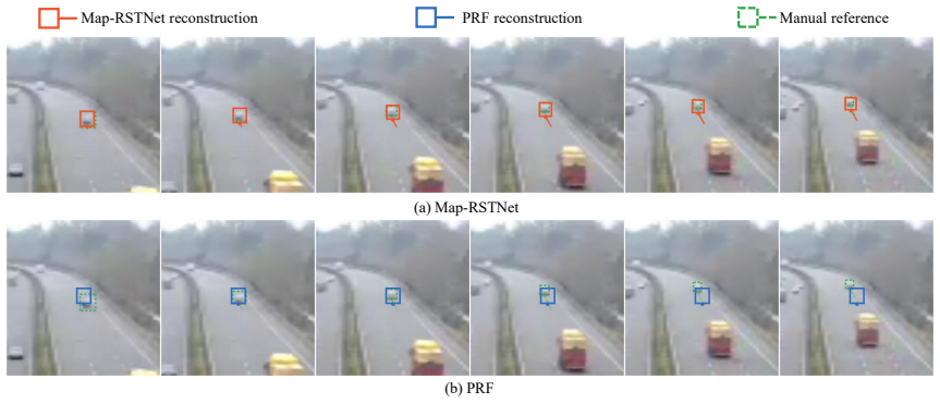
Summary. LoRFT is introduced as the first open benchmark for long-range vehicle trajectory reconstruction from fixed highway cameras, containing 22 expressway scenes, 366,109 frames, 6,601 manually verified trajectories, 2,694,889 bounding boxes, road-geometry annotations, scene-level splits, and evaluation scripts. The paper also proposes Map-RSTNet, a map-aware residual Seq2Seq LSTM that reconstructs a distant trajectory segment from a reliable near-field tracklet in a road-aligned state space with dynamic geometry refresh. The central claim is that Map-RSTNet reduces ADE, FDE, and RMSE@5s by 11.0%, 15.4%, and 10.5%, respectively, relative to the strongest baseline (PRF) on a held-out test set of 4 scenes.
Significance. The benchmark addresses a real gap: existing highway datasets are either overhead or do not supply manually verified far-range continuations of fragmented tracklets. The evaluation protocol is well designed—scene-level splits prevent leakage, labels are manually verified and independent of the proposed model, and the released code and evaluation scripts support reproducibility. The method is sensible, and the ablation is internally consistent with Table 2. The principal weakness is that the benchmark's resolution is not established: the reported improvements are a few pixels, and no label-quality analysis is provided to show that these differences exceed annotation noise. If that gap is closed, the paper would be a solid contribution.
major comments (4)
- [Sec. 3.2, Table 2] The central quantitative claim rests on small pixel differences: Map-RSTNet beats PRF by 1.53 px ADE (12.32 vs 13.85), 3.96 px FDE (21.71 vs 25.67), and 3.23 px RMSE@5s (27.47 vs 30.70). The paper provides no inter-annotator agreement, no localization-noise measurement, and no label-error analysis as a function of distance. Given that the paper itself states that distant vehicles are 'small or blurred in a single frame' (Sec. 2.2) and that identities are verified from motion continuity (Sec. 3.2), the reference labels could plausibly carry several pixels of noise. Without a label-quality study, the benchmark cannot be certified as a measurement instrument capable of resolving the reported differences, and the claimed margins might be within the noise floor. Please add re-annotation of a random subset by multiple annotators (reporting per-point standard deviation, box IoU, or similar), a
- [Sec. 5.1, Sec. 5.3] All results are reported from a single training run. The absolute differences are small (a few pixels), and deep sequence models can exhibit nontrivial variance across random seeds. Without multiple runs and error bars, or a paired statistical test across test trajectories, the 11–15% relative improvements are not established as beyond run-to-run variation. Please report mean ± standard deviation over at least three seeds and, ideally, a paired test (e.g., Wilcoxon signed-rank over trajectories) for the headline metrics.
- [Sec. 5.3] The evaluation protocol says the baselines are 'adapted' to LoRFT, but the manuscript does not specify the adaptation details: input/output representations, whether map information was provided to each baseline, training schedules, hyperparameter searches, or model capacities. If the baselines were not given comparable tuning, the comparison is not a fair test of Map-RSTNet's advantage. Provide complete configuration details or release the baseline code/configs so the comparison can be reproduced and audited.
- [Sec. 4.2, Eqs. (5)-(7)] The 10-dimensional state vector contains redundant geometry terms. From Eqs. (4)–(7), ℓL_t = u_t, ℓR_t = 1 − u_t, and f_lat_t = 2u_t − 1. This redundancy does not invalidate the method, but it should be acknowledged and justified (e.g., as an intentionally overcomplete representation) or the redundant terms should be removed for clarity and reproducibility.
minor comments (4)
- [Sec. 3.2] The split between observed and reference segments is defined by the reliability of the automatic tracklet, which in this implementation is produced by YOLOv11+ByteTrack. This couples the benchmark's task definition to a particular detector/tracker. Please discuss the potential impact on the benchmark's generality and consider releasing a tracklet-reliability score to allow alternative splits.
- [Fig. 5] The hyperparameter curves appear to be on validation data, but the caption says 'on the LoRFT benchmark.' Please clarify whether these are validation or test curves, and add error bars over seeds or state explicitly that they are single-run validation results.
- [Sec. 4.2] The notation ℓL_t and ℓR_t, while defined, may confuse readers because they duplicate u_t and 1−u_t. A brief note that these are included as explicit geometry features despite the algebraic redundancy would preempt confusion.
- [Sec. 1, Abstract] The claim of being 'the first open benchmark dedicated to long-range vehicle trajectory reconstruction from fixed highway cameras' is plausible but should be supported with a more explicit discussion of why existing datasets (e.g., UA-DETRAC, CHD, V2X-Seq) cannot be repurposed for this exact protocol, rather than only that they were not designed for it.
Circularity Check
No significant circularity: benchmark references, road geometry, and method evaluation are mutually independent by construction.
full rationale
The paper's central claims are not circular. LoRFT's ground-truth reference segments are manually verified image-space annotations derived from the videos (Sec. 3.2), independent of Map-RSTNet's predictions. The road-geometry prior M={B,C,Z} is a separately annotated scene-level input, not derived from the reference labels. Map-RSTNet is trained with the objective in Eq. 12 on observed/reference pairs from training scenes, with all hyperparameters selected on validation, and is evaluated on held-out test scenes (Sec. 5.1). Therefore the reported ADE/FDE/RMSE reductions in Table 2 are not fitted to the test labels by construction. The model's output is recovered via Eq. 15 and compared with the reference via Eq. 16; these are distinct quantities, not the same by definition. There is no load-bearing self-citation: the cited prior datasets and methods are background support, and no uniqueness or ansatz is imported solely from the authors' own prior work. The unquantified far-range annotation noise noted in the skeptic's take is a measurement-quality and benchmark-resolution concern, not a circularity, because it does not make any prediction equal its input or any fitted parameter the renamed target. Thus the derivation chain is self-contained and the circularity score is 0.
Assumptions & free parameters
free parameters (4)
- Loss weights (λpos=1200, λvel=10, λend=150, λbdry=40) =
1200 / 10 / 150 / 40
- Decoder step clamp δmax =
0.04
- Velocity scaling factor αv =
10
- Observation horizon; geometry refresh interval =
60 frames; 1 frame
assumptions (5)
- domain assumption Far-range vehicle identity can be resolved by annotators from motion continuity across neighboring frames, and the resulting boxes are accurate enough to serve as reconstruction ground truth.
- domain assumption The reliability boundary of the YOLOv11 + ByteTrack pipeline is a sensible, stable definition of where the observed segment ends and the reconstruction target begins.
- domain assumption Image-space road-geometry annotations (boundaries, centerlines, zone direction) are accurate in the distant region where reconstruction is evaluated.
- domain assumption Pixel-space error is an adequate evaluation metric despite the absence of scene-specific camera calibration.
- standard math Standard background is sound: LSTM Seq2Seq training, Rauch-Tung-Striebel smoothing, Adam optimization, and the L2/smooth-L1 losses behave as intended.
Cite this review
Pith. "Pith review of LoRFT: Benchmarking Long-Range Vehicle Trajectory Reconstruction from Fixed Highway Cameras." pith.science (2026). https://pith.science/paper/JS5ZEAM5
@misc{pith2026260719911,
  author       = {Pith},
  title        = {Pith review of: LoRFT: Benchmarking Long-Range Vehicle Trajectory Reconstruction from Fixed Highway Cameras},
  year         = {2026},
  howpublished = {\url{https://pith.science/paper/JS5ZEAM5}},
  note         = {Machine review of arXiv:2607.19911}
}
read the original abstract
Long-range vehicle trajectories provide important spatio-temporal evidence for traffic safety analysis, autonomous driving evaluation, and data-driven traffic management, yet continuously recovering them from fixed highway cameras remains difficult. As vehicles recede into distant road regions, perspective compression and scale decay often fragment or prematurely terminate automatic tracklets, even when their continuation remains identifiable from motion consistency across neighboring frames. We formulate this problem as recovering the far-range continuation of a vehicle trajectory from a reliable near-field tracklet. We introduce LoRFT, to our knowledge the first open benchmark dedicated to long-range vehicle trajectory reconstruction from fixed highway cameras. LoRFT comprises 22 expressway surveillance scenes, 366,109 video frames, 6,601 manually verified trajectories, 2,694,889 bounding boxes, road-geometry annotations, scene-level splits, and evaluation scripts. We further propose Map-RSTNet, a map-aware residual sequence-to-sequence model that reconstructs distant trajectories in a road-geometry-aligned state space and dynamically refreshes local road geometry during decoding. On LoRFT, Map-RSTNet reduces ADE, FDE, and 5-second RMSE by 11.0%, 15.4%, and 10.5%, respectively, relative to the strongest baseline. These results demonstrate that road-geometry-aware reconstruction can extend usable trajectory records from existing fixed-camera infrastructure. LoRFT provides a reproducible testbed for long-range vehicle trajectory reconstruction.
Figures


Figures from the paper (2 more)

Reference graph
Works this paper leans on
-
[1]
Itpnet: Towards instanta- neous trajectory prediction for autonomous driving,
R. Li, C. Li, Y. Li, H. Li, Y. Chen, Y. Yuan, and G. Wang, “Itpnet: Towards instanta- neous trajectory prediction for autonomous driving,” inProc. 30th ACM SIGKDD Conf. Knowledge Discovery and Data Mining (KDD), 2024, pp. 1643–1654. 14
2024
-
[2]
Trajectory-LLM: A language-based data generator for trajectory prediction in autonomous driving,
K. Yang, Z. Guo, G. Lin, H. Dong, Z. Huang, Y. Wu, D. Zuo, J. Peng, Z. Zhong, X. Wang, Q. Guo, X. Jia, J. Yan, and D. Lin, “Trajectory-LLM: A language-based data generator for trajectory prediction in autonomous driving,” inProc. International Conference on Learning Representations (ICLR), 2025
2025
-
[3]
A deep transfer learning approach for real-time traffic conflict prediction with trajectory data,
Q. Hou, Y. Yang, J. Liang, X. Huo, and J. Leng, “A deep transfer learning approach for real-time traffic conflict prediction with trajectory data,”Accident Analysis & Prevention, vol. 214, 2025, art. no. 107966
2025
-
[4]
Traffic state estimation from vehicle trajectories with anisotropic gaussian processes,
F. Wu, Z. Cheng, H. Chen, Z. Qiu, and L. Sun, “Traffic state estimation from vehicle trajectories with anisotropic gaussian processes,”Transportation Research Part C: Emerging Technologies, vol. 163, Jun. 2024, art. no. 104646
2024
-
[5]
Traffic light optimization with low penetration rate vehicle trajectory data,
X. Wang, Z. Jerome, Z. Wang, C. Zhang, S. Shen, V. V. Kumar, F. Bai, P. Krajewski, D. Deneau, A. Jawad, R. Jones, G. Piotrowicz, and H. X. Liu, “Traffic light optimization with low penetration rate vehicle trajectory data,”Nature Communications, vol. 15, no. 1, 2024, art. no. 1306
2024
-
[6]
HDSVT: High-density semantic vehicle trajectory dataset based on a cosmopolitan city bridge,
D. Wen, Y. Zhu, Z. Wu, Z. Wu, Q. Zheng, S. Wang, Y. Wang, and Z. He, “HDSVT: High-density semantic vehicle trajectory dataset based on a cosmopolitan city bridge,” Scientific Data, vol. 13, 2026, art. no. 5
2026
-
[7]
I-24 motion: An instrument for freeway traffic science,
D. Gloudemans, Y. Wang, J. Ji, G. Zach´ ar, W. Barbour, E. Hall, M. Cebelak, L. Smith, and D. B. Work, “I-24 motion: An instrument for freeway traffic science,”Transportation Research Part C: Emerging Technologies, vol. 155, Oct. 2023, art. no. 104311
2023
-
[8]
The highd dataset: A drone dataset of naturalistic vehicle trajectories on german highways for validation of highly automated driving systems,
R. Krajewski, J. Bock, L. Kloeker, and L. Eckstein, “The highd dataset: A drone dataset of naturalistic vehicle trajectories on german highways for validation of highly automated driving systems,” inProc. IEEE 21st Int. Conf. Intelligent Transportation Systems (ITSC), 2018, pp. 2118–2125
2018
Show all 40 references
-
[9]
The exid dataset: A real-world trajectory dataset of highly interactive highway scenarios in germany,
T. Moers, L. Vater, R. Krajewski, J. Bock, A. Zlocki, and L. Eckstein, “The exid dataset: A real-world trajectory dataset of highly interactive highway scenarios in germany,” inProc. IEEE Intelligent Vehicles Symposium (IV), 2022, pp. 958–964
2022
-
[10]
Transportation management center video recording and archiving best general practices,
S. Kuciemba and K. Swindler, “Transportation management center video recording and archiving best general practices,” Federal Highway Administration, Tech. Rep. FHW A- HOP-16-033, Mar. 2016
2016
-
[11]
Real-time full-stack traffic scene perception for autonomous driving with roadside cameras,
Z. Zou, R. Zhang, S. Shen, G. Pandey, P. Chakravarty, A. Parchami, and H. X. Liu, “Real-time full-stack traffic scene perception for autonomous driving with roadside cameras,” inProc. IEEE Int. Conf. Robotics and Automation (ICRA), 2022, pp. 890–896
2022
-
[12]
Real-time incremental segmentation and tracking of vehicles at low camera angles using stable features,
N. K. Kanhere and S. T. Birchfield, “Real-time incremental segmentation and tracking of vehicles at low camera angles using stable features,”IEEE Transactions on Intelligent Transportation Systems, vol. 9, no. 1, pp. 148–160, Mar. 2008
2008
-
[13]
Rope3d: The roadside perception dataset for autonomous driving and monocular 3d object detection task,
X. Ye, M. Shu, H. Li, Y. Shi, Y. Li, G. Wang, X. Tan, and E. Ding, “Rope3d: The roadside perception dataset for autonomous driving and monocular 3d object detection task,” in Proc. IEEE/CVF Conf. Computer Vision and Pattern Recognition (CVPR), 2022, pp. 21 341–21 350
2022
-
[14]
Ua- detrac: A new benchmark and protocol for multi-object detection and tracking,
L. Wen, D. Du, Z. Cai, Z. Lei, M.-C. Chang, H. Qi, J. Lim, M.-H. Yang, and S. Lyu, “Ua- detrac: A new benchmark and protocol for multi-object detection and tracking,”Computer Vision and Image Understanding, vol. 193, Apr. 2020, art. no. 102907. 15
2020
-
[15]
A pov-based highway vehicle trajectory dataset and prediction architecture,
V. Katariya, G. Alinezhad Noghre, A. Danesh Pazho, and H. Tabkhi, “A pov-based highway vehicle trajectory dataset and prediction architecture,”IEEE Transactions on Intelligent Transportation Systems, vol. 25, no. 10, pp. 13 136–13 146, Oct. 2024
2024
-
[16]
The next generation simulation program,
V. Alexiadis, J. Halkias, G. McHale, J. Colyar, and R. Hranac, “The next generation simulation program,”ITE Journal, vol. 74, no. 8, pp. 22–26, 2004
2004
-
[17]
V2x-seq: A large-scale sequential dataset for vehicle- infrastructure cooperative perception and forecasting,
H. Yu, W. Yang, H. Ruan, Z. Yang, Y. Tang, X. Gao, X. Hao, Y. Shi, Y. Pan, N. Sun, J. Song, J. Yuan, P. Luo, and Z. Nie, “V2x-seq: A large-scale sequential dataset for vehicle- infrastructure cooperative perception and forecasting,” inProc. IEEE/CVF Conf. Computer Vision and P...
2023
-
[18]
The ind dataset: A drone dataset of naturalistic road user trajectories at german intersections,
J. Bock, R. Krajewski, T. Moers, S. Runde, L. Vater, and L. Eckstein, “The ind dataset: A drone dataset of naturalistic road user trajectories at german intersections,” inProc. IEEE Intelligent Vehicles Symposium (IV), 2020, pp. 1929–1934
2020
-
[19]
The round dataset: A drone dataset of road user trajectories at roundabouts in germany,
R. Krajewski, T. Moers, J. Bock, L. Vater, and L. Eckstein, “The round dataset: A drone dataset of road user trajectories at roundabouts in germany,” inProc. IEEE 23rd Int. Conf. Intelligent Transportation Systems (ITSC), 2020, pp. 1–6
2020
-
[20]
opendd: A large-scale roundabout drone dataset,
A. Breuer, J.-A. Termoehlen, S. Homoceanu, and T. Fingscheidt, “opendd: A large-scale roundabout drone dataset,” inProc. IEEE 23rd Int. Conf. Intelligent Transportation Systems (ITSC), 2020, pp. 1–6
2020
-
[21]
On the new era of urban traffic monitoring with massive drone data: The pneuma large-scale field experiment,
E. Barmpounakis and N. Geroliminis, “On the new era of urban traffic monitoring with massive drone data: The pneuma large-scale field experiment,”Transportation Research Part C: Emerging Technologies, vol. 111, pp. 50–71, Feb. 2020
2020
-
[22]
Vehicle trajectory prediction based on motion model and maneuver recognition,
A. Houenou, P. Bonnifait, V. Cherfaoui, and W. Yao, “Vehicle trajectory prediction based on motion model and maneuver recognition,” inProc. IEEE/RSJ Int. Conf. Intelligent Robots and Systems (IROS), 2013, pp. 4363–4369
2013
-
[23]
Driving intention recognition and behaviour prediction based on a double-layer hidden markov model,
L. He, C. Zong, and C. Wang, “Driving intention recognition and behaviour prediction based on a double-layer hidden markov model,”Journal of Zhejiang University-SCIENCE C, vol. 13, no. 3, pp. 208–217, Mar. 2012
2012
-
[24]
An integrated approach to maneuver-based trajectory prediction and criticality assessment in arbitrary road environments,
M. Schreier, V. Willert, and J. Adamy, “An integrated approach to maneuver-based trajectory prediction and criticality assessment in arbitrary road environments,”IEEE Transactions on Intelligent Transportation Systems, vol. 17, no. 10, pp. 2751–2766, Oct. 2016
2016
-
[25]
Machine learning for autonomous vehicle’s trajectory pre- diction: A comprehensive survey, challenges, and future research directions,
V. Bharilya and N. Kumar, “Machine learning for autonomous vehicle’s trajectory pre- diction: A comprehensive survey, challenges, and future research directions,”Vehicular Communications, vol. 46, Apr. 2024, art. no. 100733
2024
-
[26]
Convolutional social pooling for vehicle trajectory prediction,
N. Deo and M. M. Trivedi, “Convolutional social pooling for vehicle trajectory prediction,” inProc. IEEE/CVF Conf. Computer Vision and Pattern Recognition Workshops (CVPR W), 2018, pp. 1468–1476
2018
-
[27]
Deeptrack: Lightweight deep learning for vehicle trajectory prediction in highways,
V. Katariya, M. Baharani, N. Morris, O. Shoghli, and H. Tabkhi, “Deeptrack: Lightweight deep learning for vehicle trajectory prediction in highways,”IEEE Transactions on Intelligent Transportation Systems, vol. 23, no. 10, pp. 18 927–18 936, Oct. 2022
2022
-
[28]
Grip++: Enhanced graph-based interaction-aware trajectory prediction for autonomous driving,
X. Li, X. Ying, and M. C. Chuah, “Grip++: Enhanced graph-based interaction-aware trajectory prediction for autonomous driving,” arXiv preprint arXiv:1907.07792, 2020. 16
1907 arXiv
-
[29]
Scale-net: Scalable vehicle trajectory prediction network under random number of interacting vehicles via edge-enhanced graph convolutional neural network,
H. Jeon, J. Choi, and D. Kum, “Scale-net: Scalable vehicle trajectory prediction network under random number of interacting vehicles via edge-enhanced graph convolutional neural network,” inProc. IEEE/RSJ Int. Conf. Intelligent Robots and Systems (IROS), 2020, pp. 2095–2102
2020
-
[30]
Densetnt: End-to-end trajectory prediction from dense goal sets,
J. Gu, C. Sun, and H. Zhao, “Densetnt: End-to-end trajectory prediction from dense goal sets,” inProc. IEEE/CVF Int. Conf. Computer Vision (ICCV), 2021, pp. 15 283–15 292
2021
-
[31]
Learning lane graph representations for motion forecasting,
M. Liang, B. Yang, R. Hu, Y. Chen, R. Liao, S. Feng, and R. Urtasun, “Learning lane graph representations for motion forecasting,” inComputer Vision – ECCV 2020, ser. Lecture Notes in Computer Science. Cham, Switzerland: Springer, 2020, vol. 12347, pp. 541–556
2020
-
[32]
Vectornet: Encoding hd maps and agent dynamics from vectorized representation,
J. Gao, C. Sun, H. Zhao, Y. Shen, D. Anguelov, C. Li, and C. Schmid, “Vectornet: Encoding hd maps and agent dynamics from vectorized representation,” inProc. IEEE/CVF Conf. Computer Vision and Pattern Recognition (CVPR), 2020, pp. 11 525–11 533
2020
-
[33]
Mixnet: Physics constrained deep neural motion prediction for autonomous racing,
P. Karle, F. Toeroek, M. Geisslinger, and M. Lienkamp, “Mixnet: Physics constrained deep neural motion prediction for autonomous racing,”IEEE Access, vol. 11, pp. 85 914–85 926, 2023
2023
-
[34]
Goal- based neural physics vehicle trajectory prediction model,
R. Gan, H. Shi, P. Li, K. Wu, B. An, J. You, L. Li, J. Ma, C. Ma, and B. Ran, “Goal- based neural physics vehicle trajectory prediction model,”Transportation Research Part C: Emerging Technologies, vol. 179, Oct. 2025, art. no. 105283
2025
-
[35]
Uncovering the missing pattern: Unified framework towards trajectory imputation and prediction,
Y. Xu, A. Bazarjani, H. Chi, C. Choi, and Y. Fu, “Uncovering the missing pattern: Unified framework towards trajectory imputation and prediction,” inProc. IEEE/CVF Conf. Computer Vision and Pattern Recognition (CVPR), 2023, pp. 9632–9643
2023
-
[36]
Automatic vehicle trajectory data reconstruction at scale,
Y. Wang, D. Gloudemans, J. Ji, Z. N. Teoh, L. Liu, G. Zach´ ar, W. Barbour, and D. Work, “Automatic vehicle trajectory data reconstruction at scale,”Transportation Research Part C: Emerging Technologies, vol. 160, Mar. 2024, art. no. 104520
2024
-
[37]
Trajrecovery: An efficient vehicle trajectory recovery framework based on urban-scale traffic camera records,
D. Wu, Z. Fang, Q. Sun, L. Chen, H. Hu, F. Wang, and Y. Gao, “Trajrecovery: An efficient vehicle trajectory recovery framework based on urban-scale traffic camera records,” in Proc. 30th ACM SIGKDD Conf. Knowledge Discovery and Data Mining (KDD), 2024, pp. 5979–5990
2024
-
[38]
A data-driven and kinematics- aware approach to reconstruct full-sample vehicle trajectories from low-quality roadside perception data,
Z. Zeng, C. Zhao, S. Wang, Y. Ji, C. Wang, and Y. Du, “A data-driven and kinematics- aware approach to reconstruct full-sample vehicle trajectories from low-quality roadside perception data,”IEEE Transactions on Intelligent Transportation Systems, vol. 26, no. 10, pp. 15 041–1...
2025
-
[39]
Bytetrack: Multi-object tracking by associating every detection box,
Y. Zhang, P. Sun, Y. Jiang, D. Yu, Z. Yuan, P. Luo, W. Liu, and X. Wang, “Bytetrack: Multi-object tracking by associating every detection box,” inComputer Vision – ECCV 2022, ser. Lecture Notes in Computer Science. Cham, Switzerland: Springer, 2022, vol. 13682, pp. 1–21
2022
-
[40]
Recover to Predict: Progressive retrospective learning for variable-length trajectory prediction,
H. Zhou, L. Qi, X. Li, J. Zhang, Y. Liu, X. Yang, M. Fan, and F. Luo, “Recover to Predict: Progressive retrospective learning for variable-length trajectory prediction,” in Proc. IEEE/CVF Conf. Comput. Vis. Pattern Recogn. (CVPR), Jun. 2026, pp. 17 863– 17 873. 17
2026
Reviewed August 1, 2026 · model on record in the stance chip above.
Discussion (0). Continue with ORCID to comment.